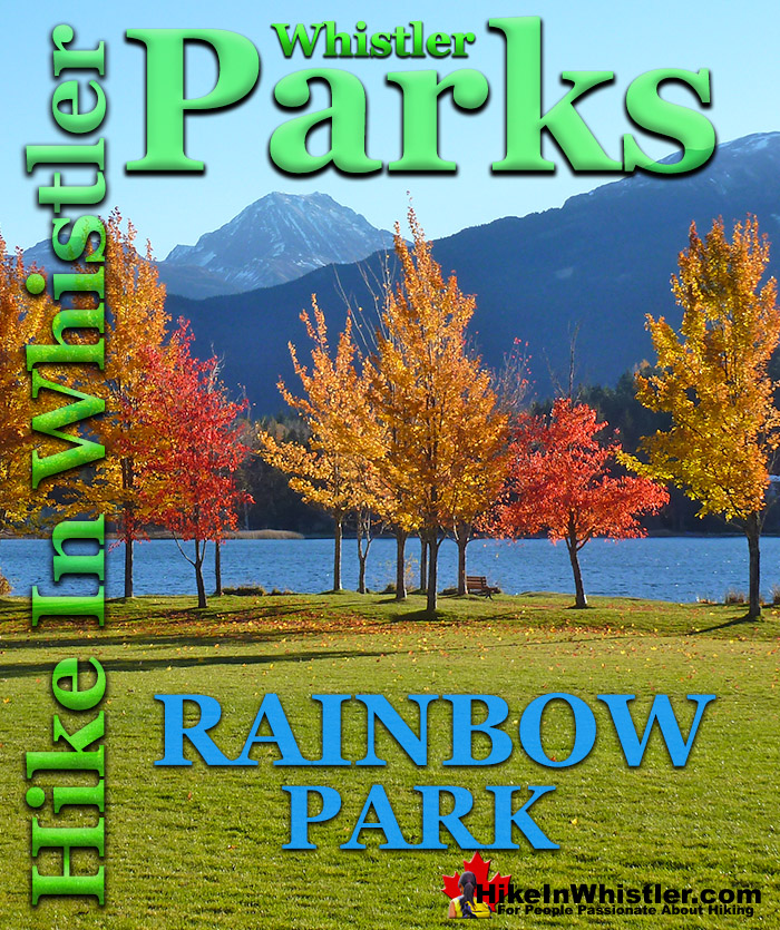
![]() Rainbow Park is one of Whistler's most popular sightseeing, picnicking, dog walking, relaxing and swimming beaches and for good reason. The beach is south facing so every morning the sun rises from behind Wedge Mountain and the whole park seems to glow. From the dazzling reflecting from the snow off of Wedge Mountain, Blackcomb Mountain and Whistler Mountain, to the amazing blue glow from Alta Lake. **Closed due to construction until June 2024.
Rainbow Park is one of Whistler's most popular sightseeing, picnicking, dog walking, relaxing and swimming beaches and for good reason. The beach is south facing so every morning the sun rises from behind Wedge Mountain and the whole park seems to glow. From the dazzling reflecting from the snow off of Wedge Mountain, Blackcomb Mountain and Whistler Mountain, to the amazing blue glow from Alta Lake. **Closed due to construction until June 2024.
Whistler & Garibaldi Hiking
![]() Alexander Falls
Alexander Falls ![]() Ancient Cedars
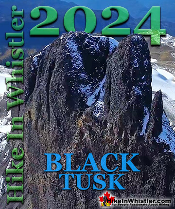
Ancient Cedars ![]() Black Tusk
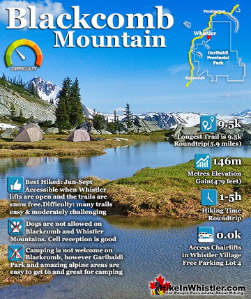
Black Tusk ![]() Blackcomb Mountain
Blackcomb Mountain ![]() Brandywine Falls
Brandywine Falls ![]() Brandywine Meadows
Brandywine Meadows ![]() Brew Lake
Brew Lake ![]() Callaghan Lake
Callaghan Lake ![]() Cheakamus Lake
Cheakamus Lake ![]() Cheakamus River
Cheakamus River ![]() Cirque Lake
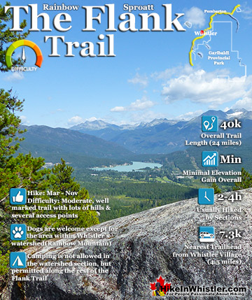
Cirque Lake ![]() Flank Trail
Flank Trail ![]() Garibaldi Lake
Garibaldi Lake ![]() Garibaldi Park
Garibaldi Park ![]() Helm Creek
Helm Creek ![]() Jane Lakes
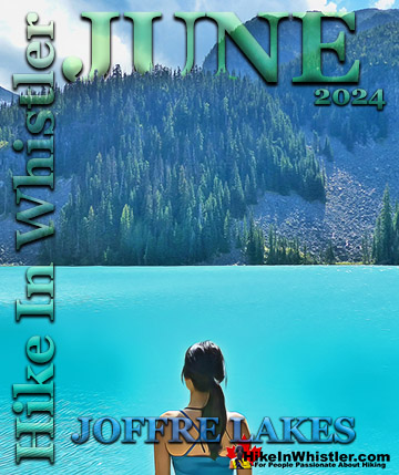
Jane Lakes ![]() Joffre Lakes
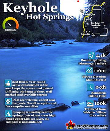
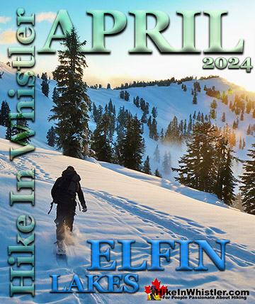
Joffre Lakes ![]() Keyhole Hot Springs
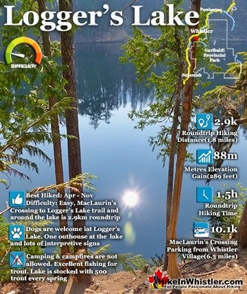
Keyhole Hot Springs ![]() Logger’s Lake
Logger’s Lake ![]() Madeley Lake
Madeley Lake ![]() Meager Hot Springs
Meager Hot Springs ![]() Nairn Falls
Nairn Falls ![]() Newt Lake
Newt Lake ![]() Panorama Ridge
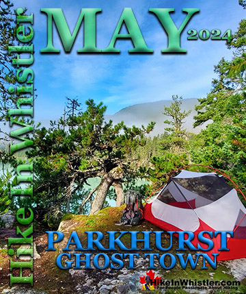
Panorama Ridge ![]() Parkhurst Ghost Town
Parkhurst Ghost Town ![]() Rainbow Falls
Rainbow Falls ![]() Rainbow Lake
Rainbow Lake ![]() Ring Lake
Ring Lake ![]() Russet Lake
Russet Lake ![]() Sea to Sky Trail
Sea to Sky Trail ![]() Skookumchuck Hot Springs
Skookumchuck Hot Springs ![]() Sloquet Hot Springs
Sloquet Hot Springs ![]() Sproatt East
Sproatt East ![]() Sproatt West
Sproatt West ![]() Taylor Meadows
Taylor Meadows ![]() Train Wreck
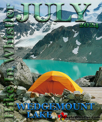
Train Wreck ![]() Wedgemount Lake
Wedgemount Lake ![]() Whistler Mountain
Whistler Mountain
Whistler Parks & Lakes
![]() Alpha Lake Park
Alpha Lake Park ![]() Alta Lake Park
Alta Lake Park ![]() Blueberry Park
Blueberry Park ![]() Green Lake Park
Green Lake Park ![]() Lakeside Park
Lakeside Park ![]() Lost Lake Park
Lost Lake Park ![]() Meadow Park
Meadow Park ![]() Nita Lake Park
Nita Lake Park ![]() Rainbow Park
Rainbow Park ![]() Wayside Park
Wayside Park
All this framed in the dazzling green of the forest all around. Though there are many great places to watch the sun rise in Whistler, Rainbow Park is one of the best. Rainbow Park gets its name from Rainbow Lodge, a popular stop along the train line from 1914 to 1974. It was a fishing and relaxing destination and easily accessible from Vancouver via the train route that still runs through the park. Run by Myrtle and Alex Philip, the original lodge burned down in 1977. Some of the remaining log houses have been restored into the outdoor museum of sorts you see there today. Interpretive panels with photos and descriptions of life in the area almost a century ago. These houses go mostly unnoticed as the main interpretive area is just off of the main beach across the Bridge of Sighs. Named by Alex Philip, the current bridge is a reconstruction of the original. There is a photo and description of the original that you can compare with the reconstruction. You will notice as you read the various panels how everything in Whistler now seems to be named after the people that once lived in and around the Rainbow Lodge community. Rainbow Park has a beautiful and very long pier that stretches far out on Alta Lake. Beyond the pier there are two swimming(island) platforms. Volleyball nets, a concession stand and washrooms sit further back from the beach. There is a large area of beach set aside as a dog park and several picnic tables. The popularity of Rainbow Park is largely due to the incredible setting. Wedge Mountain, Blackcomb Mountain and Whistler Mountain look incredible across the lake. Sunset over the lake lights up the mountains in a brilliant gold colour that is spectacular. In the morning the sun rises over Wedge Mountain casting shade over Alta Lake leaving the mountains and lake in a haunting darkness while the sky is a powerfully bright, deep blue colour.


Wedge Mountain, the highest mountain in Garibaldi Provincial Park to the left of Blackcomb looks both enormous and definitely wedge shaped. Every direction you look you are captivated by the surroundings. Out on the pier you look left and right along the huge valley that contains Alta Lake and at the far end you trace Whistler Mountain from the water to the sky. You can see where the Peak Chair, or at least the alpine rock and snow where it sits on top of high up above the treeline. The Cloudraker Skybridge is visible just to the right of the Peak Chair, also at the summit of Whistler Mountain. Lower down the mountain the Peak 2 Peak Gondola stretches across, connecting Whistler Mountain and Blackcomb Mountain. Rainbow Park sits on the far side of Alta Lake. From Whistler Village it is just over 3 kilometres and the entire route is scenic.

From the Village the Valley Trail passes underneath the Sea to Sky Highway and at the Whistler Golf Course clubhouse it branches in two directions. Left takes you around the golf course and to Alta Lake's near shore and past Blueberry Park, Lakeside Park and Wayside Park before rounding the south end of the lake and on to Alta Lake Road to Rainbow Park. The map below shows the more direct route, which turns right at the clubhouse and follows the Valley Trail along the golf course and through the beautiful, old-growth cedar forest at its top end. The Valley Trail then veers away from the golf course and runs along Lorimer Road briefly before branching left and following the River of Golden Dreams to Alta Lake and Rainbow Park.

The 1 kilometre section of Valley Trail between Lorimer Road and Rainbow Park is very nice. There are a few good places to stop along the River of Golden Dreams. A great viewpoint over Alta Lake, a small rocky beach where two creeks meet and a boat portage area with a deck on the river next to a fish weir. All of this section of trail is within a deep and beautiful forest with gaps in the forest revealing different mountains at every bend in the trail. If you want to walk, bike or run past Rainbow Park and continue around Alta Lake you just have to go along Alta Lake Road for 1.3 kilometres until it rejoins the Valley Trail again. There is a shortcut to Alta Lake Road from Rainbow Park. Immediately after you cross the train tracks take the unmarked trail on your left. It zig-zags once through the trees and comes to Alta Lake Road. Turn left onto Alta Lake Road and then after 1.3 kilometres look to your left for the Valley Trail. Whistler's beautiful Valley Trail system has excellent and clear signs at every junction on the trail and takes you past one gorgeous park after another.

If you start walking from Whistler Village, starting between Buffalo Bills and the Conference Centre you will come to Whistler Way and see this underpass under the Sea to Sky Highway. This is where the Valley Trail exits the Village heading either north or south. Walking, biking or jogging under the underpass you will come to the Whistler Golf Course parking lot and clubhouse with the Valley Trail branching both right and left(north and south). Here you will find a nice mapboard showing the Valley Trail and the Sea to Sky Trail. The Sea to Sky Trail follows on top of the Valley Trail through this section and much of Whistler). You can get to Rainbow Park by turning right and following the edge of Whistler Golf Course(on your left). The route is fairly straight forward and you will find signs at every fork in the trail.

Though getting to Rainbow Park on foot or by bike is half the fun due to how scenic and convenient the Valley Trail system is in Whistler, driving is also a nice alternative. Rainbow Park is located on Alta Lake's far shore and is accessed by Alta Lake Road. Alta Lake Road is a a scenic and winding road that runs along the opposite side of the valley to the Sea to Sky Highway. This winding road is often concealed in deep forest, but there are some nice viewpoints along the way to Rainbow Park. The most direct route from Whistler Village is to head north on the Sea to Sky Highway, (aka 99). Just under 4 kilometres from Whistler Village, turn left into Alpine via Alpine Way. At the stop sign turn left at Rainbow Drive and in 3 kilometres look for the entrance on your left to Rainbow Park. (Rainbow Drive becomes Alta Lake Road after 1 kilometre).
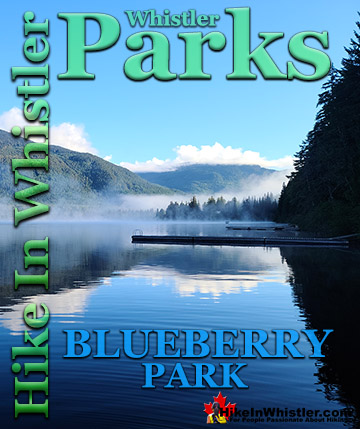
Rainbow Park is definitely one of the most dog friendly parks in Whistler with its dedicated dog park/beach area located next to the large pier at the end of the main beach. The Valley Trail in general is a popular dog walking trail in Whistler and Rainbow Park via the short trail at Lorimer Road is particularly popular. The dead end of Lorimer Road in Whistler Cay, is just a two minute drive from Whistler Village and there is plenty of street parking available. Parking at the end of Lorimer Road puts you at a nice junction on the Valley Trail. It extends off in four directions just steps from your car. Rainbow Park is 1k one way and Meadow Park is 2k another way. Whistler Village is 2k or 3k depending on which way you go around the Whistler Golf Course. Or more directly, just 1.3k if you walk along the Valley Trail adjacent to Lorimer Road. Alpha Lake Park also has a dedicated dog park area attached to it, while Blueberry Park is more or less, entirely a dog park due to its remote feeling, wilderness setting. For a list of Whistler's best hiking trails that are dog friendly try here..

There are excellent washrooms at Rainbow Park located next to the parking lot. These are reliably open during daylight hours year-round. If you are travelling by the Valley Trail the next washrooms are quite far away. There is an outhouse located along the Valley Trail, by the portage area at the edge of the River of Golden Dreams. On the map below, the portage area is halfway between Rainbow Park and Lorimer Road, just past where the Valley Trail crosses the River of Golden Dreams. At the top end of Whistler Golf Course there is are public washrooms at the small food and drink area for golfers. Look for the sign on the Valley Trail during daylight hours in the months that the golf course is open. Rainbow Park is a park and of course camping is not permitted. However, it is such a remote feeling park after dusk that it is not unusual to spot a tent nestled against the trees at the edge of the beach. Just like so many other places around Whistler, if you aren't in anyone's face about what you do, you won't be bothered. Therefore, the occasional tent will almost always go unnoticed. With the fantastically beautiful sunsets and sunrises at the park, the draw is obvious. If you are after a more orthodox and legal place to put up your tent, you don't have to look far.

A River Runs Through It
If you look closely at one of the parking lots in Rainbow Park, you will see a small trail sign for the wonderful trail that takes you through this secluded forest, all the way to Emerald Forest. A River Runs Through It is an insanely winding trail that follows a dizzying route through this captivating forest with Twentyone Mile Creek running through it. A popular, though brutally challenging bike trail, A River Runs Through It has numerous, elaborate ramps, small bridges, and one large bridge that spans Twentyone Mile Creek.

A River Runs Through It has a couple shortcut trails that cut a couple kilometres off of it to make it a more manageable and enjoyable hiking trail. If you add in another two connecting trails, you can turn A River Runs Through It into a beautiful 6 kilometre circle route. You can start this circle route from a couple spots on Alta Lake Road, or at Rainbow Park, or at the end of Lorimer Road. The end of Lorimer Road starting point has the advantage of being very close to Whistler Village. You can drive to this starting point from Whistler Village in 3 minutes, or bike there in 8 minutes, or walk there in 22 minutes. From the end of Lorimer Road you get on the Valley Trail, cross the bridge over the River of Golden Dreams, then cross the train tracks and enter Emerald Forest on your left. Climbing up the trail that skirts the gravel pit leads you to the top of the gravel pit and you then enter the deep, dark, emerald coloured forest. From here A River Runs Through It continues its wildly meandering course through the forest.

This is a nice 2.4 kilometre walk in the woods that takes you through this very scenic forest to a bunch of nice creek views. If you prefer to take another shortcut, you will see, just after the bridge crossing, the Rainbow Express trail cut through the forest in a fairly direct 300 metre route to reconnect to A River Runs Through It South. This last section of A River Runs Through It is just 0.8 kilometres long and emerges at Rainbow Park. Rainbow Park is one of Whistler's countless gorgeous lakeside parks and here you will find washrooms, a sandy beach, a huge wharf, and one of Whistler's best views of Wedge, Blackcomb and Whistler mountains. The Valley Trail disappears into the forest along Alta Lake and emerges at Lorimer Road in just 1.5 kilometres, completing the 6 kilometre circle route.

The Rainbow-Sproatt Flank Trail
The Flank Trail (Rainbow-Sproatt Flank Trail) runs along the edge Mount Sproatt directly behind you if you are facing Alta Lake in Rainbow Park. There is a parking area just a couple hundred metres from Rainbow Park's parking lot. Exit onto Alta Lake Road heading right and look for sign on your left for the Rainbow Trail. If you follow the Rainbow Trail for about 20 minutes you will see the on your left. The Flank Trail runs the length of Whistler Valley, opposite Whistler Mountain and Blackcomb Mountain, and connects Rainbow Mountain and Mount Sproatt with dozens of hiking and biking trails. Mount Sproatt and Rainbow Mountain dominate the view across the valley from Whistler Village and the Flank Trail traces a 40 kilometre route along the flank of these two mountains. One end is high up in the Callaghan Valley near Whistler Olympic Park and the other is near Ancient Cedars & Showh Lakes! At various places along the trail there are access points. The Rainbow Trail trailhead is a popular access point for the Flank Trail as it enters the trail at roughly its midpoint. Another good access is in Function Junction that can be found behind 1200 Alpha Lake Road at the old trailhead to Whistler Train Wreck. Over the years the Flank Trail has been trimmed a bit. With the building of Whistler Olympic Park for the 2010 Olympics the trailhead was pushed across the valley toward Northair Mine. Much of this section of trail was, and still is old logging roads, so it doesn’t look or feel like a trail until it bends toward Whistler a few kilometres south of Northair Mine. Previous to the Olympics the Callaghan Valley trailhead was just a stones throw north of Alexander Falls at the bridge that takes you to Callaghan Lake and Madeley Lake. Now the trailhead is not marked at that end and is assumed to be north of Northair Mine at the edge of Whistler Olympic Park or at Northair Mine itself.

More Whistler Parks!

Whistler's Best Hiking Trails!
Whistler & Garibaldi Park Best Hiking by Month!

Explore BC Hiking Destinations!
Whistler Hiking Trails
Squamish Hiking Trails
Vancouver Hiking Trails

Clayoquot Hiking Trails
Victoria Hiking Trails
The West Coast Trail
