![]() Neal Carter’s third expedition into the Tantalus Range was with Charles Townsend and Hazen Nunn. This time the trio of expert mountaineers set out to finally reach the summit of Tantalus. They battled through brutally steep, difficult and dangerous terrain over glaciers and terrifying ridges.
Neal Carter’s third expedition into the Tantalus Range was with Charles Townsend and Hazen Nunn. This time the trio of expert mountaineers set out to finally reach the summit of Tantalus. They battled through brutally steep, difficult and dangerous terrain over glaciers and terrifying ridges.
Neal Carter Mountaineer
- Neal Carter Mountaineering Highlights
- First Ascents by Neal Carter
- 1920: Black Tusk North Pinnacle
- 1922: Second Ascent of The Table
- 1923: Carter/Townsend Expedition
- 1932: Mount Meager Expedition
- 1933: To the Cradle of Toba River!
- 1934: Mount Waddington Tragedy
With just a couple hundred metres from the summit the knife edge, snow covered ridge gave way to a deep chasm, too dangerous to cross. Despite the unsuccessful attempt, the expedition was later written about by Carter in a thrilling article in the Vancouver Sunday Province, along with some amazing photos taken along the way. Carter also created a wonderful photo album of the expedition which now resides in the MONOVA Museum in Vancouver.
Tantalus Range as we now know it was barely explored when Neal Carter set his eyes on it just two years earlier in the spring of 1923. All the colorful names we use today were not yet created. The range was dubbed Tantalus Range in the years previously and the tallest, most prominent peak became Mt. Tantalus. Another prominent peak climbed in 1914 was named Alpha by Basil Darling. Omega, Pelops, Niobe, Serratus, and many more were still unnamed peaks. Carter summarized the brief history of early exploration of the range:
Two of the lower summits of the eastern end of the range were ascended in 1910 by a party led by Mr. G.B. Warren. The first account of a mountaineering trip to this range is found in the 1912 Canadian Alpine Club Journal, in which Mr. B.S. Darling of the B.C. Mountaineering Club, relates his exciting experiences in leading a party on the first ascent of Mt. Tantalus in July, 1911. Mr. Darling revisited the region in July, 1914, making the first ascent of Mt. Alpha (7700 feet), which was again climbed in August, 1916, by Mr. Tom Fyles, present director of the B. C, Mountaineering Club, in company with his brother. The latter party also made the first ascent of the lower of the two peaks of Mt. Tantalus.
“Fighting Way to Mt. Tantalus’ Unconquered Peak”
On Sunday, May 24th, 1925 the Vancouver Sunday Province had a feature article titled, “Fighting Way to Mt. Tantalus’ Unconquered Peak”. The article was written by Neal Carter just a few days after his third expedition into the Tantalus Range. Three years in a row in springtime he ventured into the challenging and fairly unknown mountain range. This third expedition by Carter, he was joined by Chas Townsend and Hazen Nunn. Townsend was with Carter on his first expedition in 1923 and later that year he and Carter went on their incredible expedition into the unknown mountains around what is now Whistler. Hazen Nunn accompanied Carter on his second expedition into the Tantalus Range in 1924. The highly skilled trio were very motivated and had the ability to reach their goal as Nunn later wrote:
The Tantalus Range runs in a general North-West direction from Howe Sound and can be seen to advantage on the way to Squamish. Although not so extensive as the neighbouring Garibaldi group, it is much more rugged and precipitous. The peaks rise abruptly from the valleys to imposing heights. Mt. Tantalus, the highest peak, overlooking Garibaldi itself. The object of this year’s expedition was to climb Mt. Tantalus which lies in the northern part of the range.
Their 1925 expedition to conquer Mt. Tantalus was unsuccessful, however the expedition was wildly successful in an unexpected way. The photos they took and the articles they wrote bring the historic adventure to life in a beautiful way. It is extraordinary to see a photo of an alpine summit taken a century ago. Photos back then were rare enough, but from a snowy summit after a brutal trek. Extraordinary. The following is the account of the Tantalus expedition in the spring of 1925, mostly taken from Neal Carter's Vancouver Sunday Province article and Hazen Nunn's BC Mountaineer article, both written in 1925.

Day 1: Vancouver to Squamish River Camp
The first day was spent travelling from Vancouver to their first nights camp along Squamish River. From Vancouver to Squamish they travelled by boat ferry. From the boat dock in Squamish they then travelled 30 kilometres by “auto stage” to Chee Kye, a small settlement along Cheakamus River just upstream of the point where it joins Squamish River. They next had to get across Cheakamus River which Carter described, “..by employing “Indian Jim” to take a dugout canoe up the Squamish from Chee Kye, we could cross at the advantageous place used two years previously.” They then made their way to their first camp Hazen Nunn referred to as “Barber's abandoned lumber camp on the south bank.” This camp was in an ideal location leading to what Carter described as “a prominent ridge which led right to the heart of the highest part of the range.”
Day 2: Difficult Hike to Alpine Camp
The next morning, they began the difficult hike up the ridge through dense underbrush and swamp and which Carter described as an “African jungle”. After an hour of difficult bushwhacking, they emerged to more open terrain along the ridge which ascends steeply in a series of bluffs. Carter estimated, “..progress was made at the rate of 1500 feet elevation per hour in places.” Several hours later they reached their second nights camp. Carter wrote, “Towards the end of the day, however, the exertion began to tell, and packs were dropped with much relief at a suitable spot just below the summit. The depth of the snow was estimated at fifteen to twenty feet, and much difficulty was experienced with camp fires, which persisted in eating their way down to a considerable depth, when a fresh one would have to be built. All water was laboriously obtained by melting snow.”
Neal Carter and Hazen Nunn Tantalus Camp - April 1925

Day 3: Attempt on Mt. Tantalus
The third day of the expedition they woke early to climb Mt. Tantalus. Carter detailed the challenging day in detail.
The weather was splendid for an early start the next morning to Mt. Tantalus. The hard snow experienced along the connecting ridge gave way to the soft dry powdery variety when the head of the glacier to the right was reached, however, and it was soon realized that the peak would never be climbed that day. But by plugging along as far as possible, a trail could be made which would enable the ascent to be completed the following day. This was done, therefore, and proved quite dangerous. The party had to rope together, for the glacier is notoriously steep and broken in summer, which means that in spring a light covering of snow hides innumerable hidden crevasses. Many of the larger crevasses were already open, and occasioned much trouble in choosing a route.
Neal Carter, Hazen Nunn, Alpha & Serratus Mountains - April 1925

Hazen Nunn continues the story.
Leaving the ridge, we traversed below a series of cliffs and roped up on the margin of the glacier. A peculiar feature of Tantalus Glacier is a nunatak rising some 200 feet above the ice. This rocky pinnacle, which, owing to its shape, we called the Horn, is situated below the peak, and our course was directed towards it. At 2:30 we reached it and found the altitude to be 7,300 feet. As the peak was known to be at least 1,000 feet higher, we decided, in view of the exhausting trail breaking, to renew the attempt the next day.
Nunn, Townsend & Carter "Flashlight of the 1925 Party"

Day 4: Second Attempt on Tantalus
On day 4 they set out on their second attempt to reach the summit of Mt. Tantalus. Carter described the day.
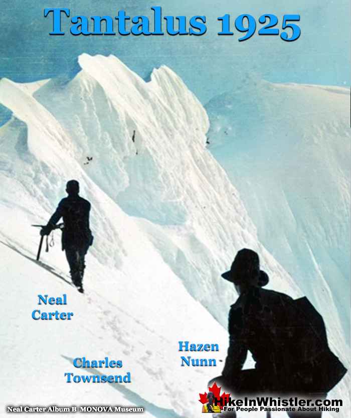
With greater hope of success, a fresh attempt was commenced the following morning and splendid time made over the already broken trail. In places, wind-drifted snow had filled it overnight, but the "Horn" at 7000 feet was reached over two hours earlier than before. From here the ascent lay up a tremendous steep slope of soft snow to a pass just below the peak; but many hours were spent battling with the crevasse stretched completely across between cliffs of the peak on one side and a rocky inaccessible ridge on the other. It looked as if progress was barred but, fortunately, a narrow ridge of snow at an angle of 45 degrees was left unmelted, and over this the party crossed with much misgiving. Once over the top of the pass a wonderful view was obtained of the country to the south between the head of Jervis Inlet and Howe Sound. The peak could be seen rising some 500 feet higher to the left, and since there seemed to be no immediate difficulty, our hopes of success were high.
Neal Carter & Hazen Nunn Approach Tantalus Summit - April 1925

Half an hour later, however, it was discovered that a narrow ridge of overhanging snow lay just in front of us, separating the summit by some 200 feet linear distance. It was deemed imprudent to attempt to cross this, for if it gave way during the process, a 6000-foot drop to the Clowholm Lakes on one hand and a 1000-foot drop to the head of the Rumbling Glacier on the other would have been sure to have put our aneroid out of order. Hence one of the most galling events had to be endured; that of stopping short of the summit. Our elevation was 8800 feet and the summit about seventy-five feet higher.
Hazen Nunn wrote about the beautiful view from the summit ridge.
From the summit ridge a wonderful panorama was enjoyed in all directions. Almost directly below us lay Clowholm Lake and Narrows Arm. This locality was once proposed as the site of a summer camp, but we could see that the peaks are not as imposing as was thought at that time. To the north lay the vast dissected coast peneplain reaching far up into the Lillooet country. The whole length of the Squamish valley could be seen, and the river followed from its headwaters down its winding course to the sea. We had a very fine view looking down on the Garibaldi range, and various features in the 1924 summer camp district were recognized.
Charles Townsend & Hazen Nunn Tantalus Summit Ridge - April 1925

Tantalus Summit Ridge Panorama - April 1925

1932: Mount Meager Expedition
