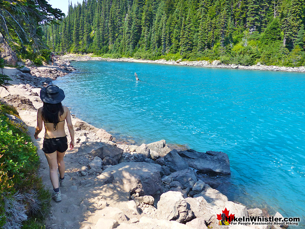
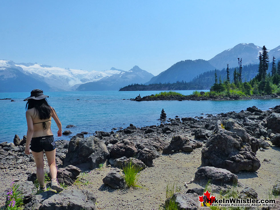
![]() Garibaldi Lake is the centre and base for much of the hiking in Garibaldi Provincial Park. The Garibaldi Lake campsite is located on the amazing, turquoise shores of this massive and mostly still wild mountain lake. There are no trails around the edge of the lake except the small section leading to the campsites, so your view is an impossibly coloured lake edged by swaths of forest and a magnificent glacier towering in the distance.
Garibaldi Lake is the centre and base for much of the hiking in Garibaldi Provincial Park. The Garibaldi Lake campsite is located on the amazing, turquoise shores of this massive and mostly still wild mountain lake. There are no trails around the edge of the lake except the small section leading to the campsites, so your view is an impossibly coloured lake edged by swaths of forest and a magnificent glacier towering in the distance.
 Huge alpine lake in a pristine forest
- Extraordinary, turquoise coloured water
- Campsites are well laid out next to the shore
- Great for swimming, but very cold
- Huge glacier is visible across the lake
- Black Tusk & Panorama Ridge are near
- Fishing is pretty good
- Hike past The The Barrier on the way to the lake
 Some find the first 6 kilometres exhausting
- Campsites are crowded together & busy
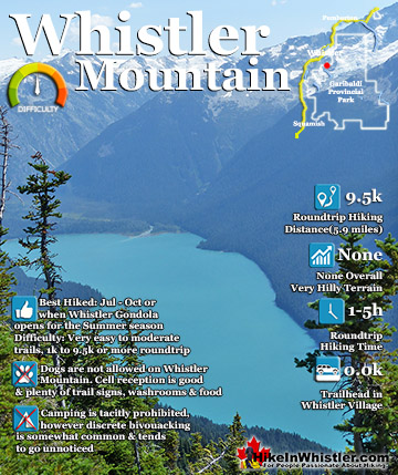
Whistler & Garibaldi Hiking
![]() Alexander Falls
Alexander Falls ![]() Ancient Cedars
Ancient Cedars ![]() Black Tusk
Black Tusk ![]() Blackcomb Mountain
Blackcomb Mountain ![]() Brandywine Falls
Brandywine Falls ![]() Brandywine Meadows
Brandywine Meadows ![]() Brew Lake
Brew Lake ![]() Callaghan Lake
Callaghan Lake ![]() Cheakamus Lake
Cheakamus Lake ![]() Cheakamus River
Cheakamus River ![]() Cirque Lake
Cirque Lake ![]() Flank Trail
Flank Trail ![]() Garibaldi Lake
Garibaldi Lake ![]() Garibaldi Park
Garibaldi Park ![]() Helm Creek
Helm Creek ![]() Jane Lakes
Jane Lakes ![]() Joffre Lakes
Joffre Lakes ![]() Keyhole Hot Springs
Keyhole Hot Springs ![]() Logger’s Lake
Logger’s Lake ![]() Madeley Lake
Madeley Lake ![]() Meager Hot Springs
Meager Hot Springs ![]() Nairn Falls
Nairn Falls ![]() Newt Lake
Newt Lake ![]() Panorama Ridge
Panorama Ridge ![]() Parkhurst Ghost Town
Parkhurst Ghost Town ![]() Rainbow Falls
Rainbow Falls ![]() Rainbow Lake
Rainbow Lake ![]() Ring Lake
Ring Lake ![]() Russet Lake
Russet Lake ![]() Sea to Sky Trail
Sea to Sky Trail ![]() Skookumchuck Hot Springs
Skookumchuck Hot Springs ![]() Sloquet Hot Springs
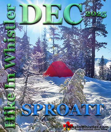
Sloquet Hot Springs ![]() Sproatt East
Sproatt East ![]() Sproatt West
Sproatt West ![]() Taylor Meadows
Taylor Meadows ![]() Train Wreck
Train Wreck ![]() Wedgemount Lake
Wedgemount Lake ![]() Whistler Mountain
Whistler Mountain
![]() January
January ![]() February
February ![]() March
March ![]() April
April ![]() May
May ![]() June
June ![]() July
July ![]() August
August ![]() September
September ![]() October
October ![]() November
November ![]() December
December
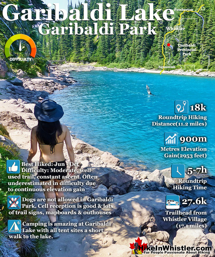
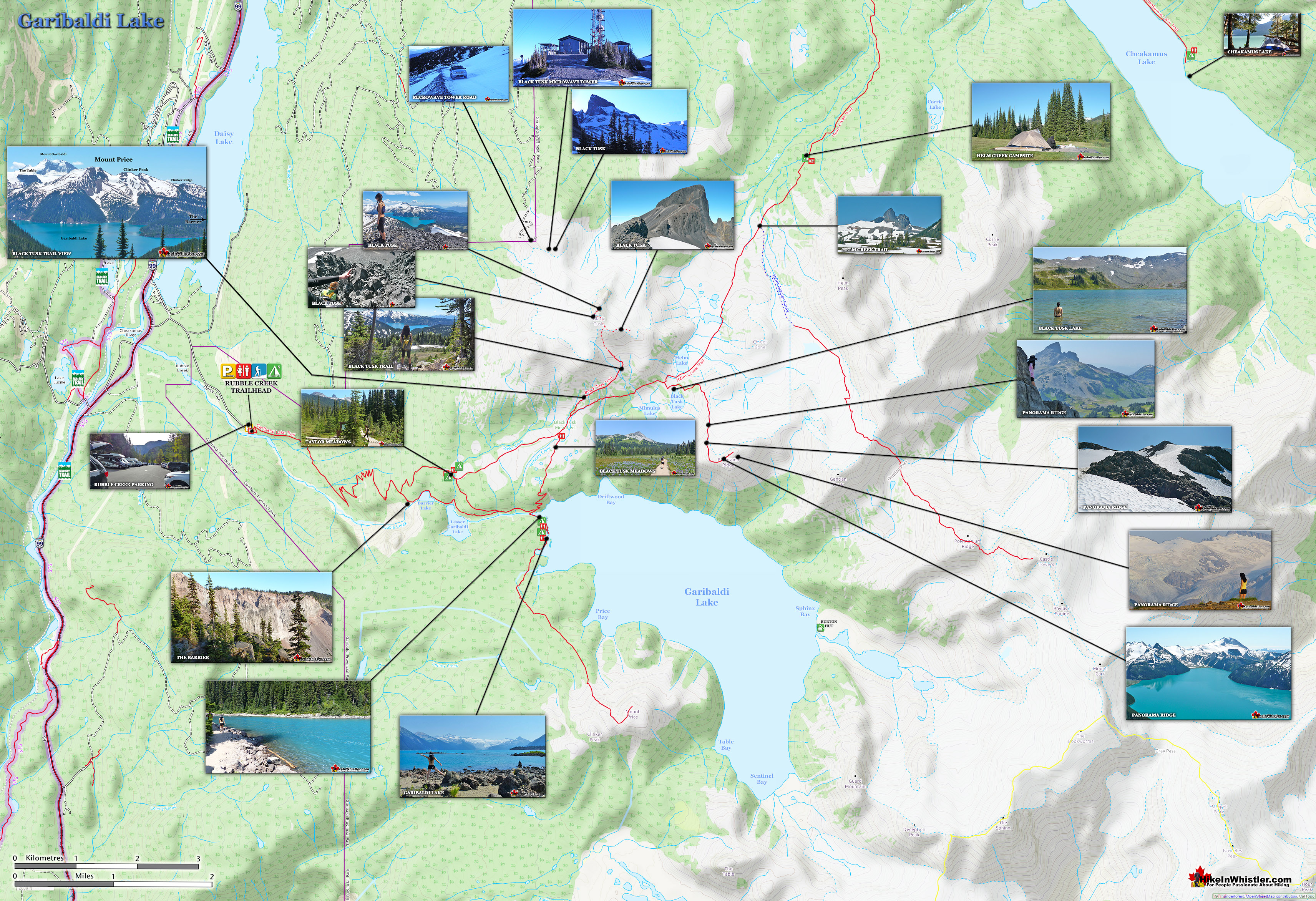
Compared to other lakes in the Whistler area and in Garibaldi Provincial Park, Garibaldi Lake is enormous with a surface area of almost 10 square kilometres or 2460 acres. It is also a very deep lake with its average depth of 119 metres or 390 feet and at its deepest, 258 metres or 849 feet! What really makes Garibaldi Lake extraordinary is its geography. It is flanked by volcanoes on three sides and lava flows from Mount Price during the last ice age formed The Barrier which blocked the valley which filled with water, creating Garibaldi Lake. Vantage points around the lake such as Panorama Ridge and Black Tusk allow relatively easy views of this magnificent lake with Mount Garibaldi and other impressive peaks surrounding it. At the Garibaldi Lake campsite the water is painfully cold, though plenty of brave hikers swim here as well as camp. Garibaldi Lake, though beautiful enough as a primary destination, is often a base camp for further hiking. The summit of Black Tusk is just a 2 hour hike from the lake. Panorama Ridge is a bit further at about 3 hours from the lake. Taylor Meadows is a beautiful, often flower filled valley, and home to the other Garibaldi Provincial Park campsites in the area. Helm Creek campsites are located past Black Tusk and Panorama Ridge, on the way to Cheakamus Lake. If you can manage transport, you can start at Rubble Creek trailhead and finish at Cheakamus Lake trailhead. This allows for a linear route instead of a there and back route. Garibaldi Lake, Taylor Meadows, Black Tusk, Panorama Ridge, Helm Creek and Cheakamus Lake are all beautiful destinations on their own, but combined in a 2 or 3 day hiking expedition are extraordinary.

Campsite Reservations in Garibaldi Park
In 2018 a lot of changes with Garibaldi Provincial Park’s campsite reservations. The first big change is that overnight camping fees are required at all campgrounds, year-round. It is still free to day hike in the park, but sleeping in the park requires a reservation and camping fees apply in all areas of Garibaldi Park. You can’t pay by cash or at the trailheads or at the campgrounds. Reservations must be made in advance via the BC Parks online reservation service or at the call centre. Hiking to Black Tusk or Panorama Ridge before mid June this year will remain very challenging and potentially dangerous. The camping area at Garibaldi Park is well laid out and stretches deep into the forest with 50 tent clearings. You can, except for the busiest of days, put your tent out of earshot and sight of others. The trail to Garibaldi Lake from the Rubble Creek trailhead, just off of the Sea to Sky Highway takes about two hours. You gain a fair amount of elevation, 900 metres in just 9 kilometres, trailhead to lake.

Partway along the trail to Garibaldi Lake the trail forks. Right to Garibaldi Lake and left goes to another beautiful campground, Taylor Meadows. Past Taylor Meadows you can link back to Garibaldi Lake by yet another linking trail. At every trail fork, there are nice and clear signs and often large mapboards showing where and how far everything is. Beyond the main camping areas of Taylor Meadows and Garibaldi Lake, there are several amazing hikes. Black Tusk and Panorama Ridge lay just beyond these two camping areas. Black Tusk or Panorama Ridge, Taylor Meadows and Garibaldi Lake can be done in one long 30 kilometre dayhike, trailhead to trailhead, but expect to take 8-10 hours. The Garibaldi Lake trailhead is located just 30 minutes south of Whistler. Keep your eye out for the hard to miss Garibaldi Provincial Park highway sign.
The Rubble Creek Trailhead - Garibaldi Lake
![]() The most scenic and direct hiking trail to Black Tusk is from the popular Rubble Creek trailhead, just off the Sea to Sky Highway, 25 kilometres south of Whistler Village. As this trailhead is also the best route to access Garibaldi Lake, Taylor Meadows and Panorama Ridge, it is sometimes very busy and some weekends find both campgrounds full. The Rubble Creek trailhead is easy to find, just keep your eye out for the large highway sign that reads, "Black Tusk(Garibaldi)" along the side of the Sea to Sky Highway 25 kilometres south of Whistler Village. The huge and free trailhead parking has a map and information board as well as an outhouse. Often you will find it full in the summer, however overflow parking extends down the side of the access road.
The most scenic and direct hiking trail to Black Tusk is from the popular Rubble Creek trailhead, just off the Sea to Sky Highway, 25 kilometres south of Whistler Village. As this trailhead is also the best route to access Garibaldi Lake, Taylor Meadows and Panorama Ridge, it is sometimes very busy and some weekends find both campgrounds full. The Rubble Creek trailhead is easy to find, just keep your eye out for the large highway sign that reads, "Black Tusk(Garibaldi)" along the side of the Sea to Sky Highway 25 kilometres south of Whistler Village. The huge and free trailhead parking has a map and information board as well as an outhouse. Often you will find it full in the summer, however overflow parking extends down the side of the access road.

Rubble Creek is so named because of the large boulder(rubble) field deposited from The Barrier in previous, massive debris flows. The last occurred more than a century ago, when The Barrier partly gave way and an estimated thirty million cubic metres of rock crashed down near the now, Rubble Creek trailhead. The Barrier can be viewed along the trail to Garibaldi Lake just past the y junction after the 6 kilometre mark along the trail. A sign indicates the short path to the viewpoint.

The trail from Rubble Creek starts off by quickly ascending a wide, dirt path into deep forest. For the first 6 kilometres you only catch glimpses of the sky through the the thick forest of startlingly tall trees. Several switchbacks along the trail continue until you get to the first fork in the trail about 6.2 kilometres from the trailhead. Right takes you to past The Barrier, Lesser Garibaldi Lake and then to Garibaldi Lake(in 3 kilometres). There is a nice mapboard at this trail junction which gives you a good chance to plot your course. A good way to hike if doing a one day hike to Black Tusk or Panorama Ridge, is to take this left fork through Taylor Meadows and then return via Garibaldi Lake for a swim near the end of the journey.


If you take the left fork toward Taylor Meadows you will finally escape the heavy forest cover and emerge to spectacular scenery in about 20 minutes. Taylor Meadows is in a beautiful valley of gnarled, weather beaten trees, endless green meadows and in July and August, alpine flowers as far as you can see. What immediately comes into view towering in the distance is Black Tusk and the wooden boardwalk through Taylor Meadows continues straight as Black Tusk looms far ahead and to your left. This is where you will start taking photos almost continuously of Black Tusk, and probably not stop until you touch its sheer black sides. Though you are only half way there, from now on the views from the trail are amazing, varied, and progressively better. Just past Taylor Meadows the boardwalk ends and the dirt trail crosses a creek and then past a small, locked BC Parks building and another trail junction. The trail to the right leads to Garibaldi Lake and campsite area in 2 kilometres. The trail that continues straight goes to Black Tusk(5.5k), the Panorama Ridge(7k) and much further away, Helm Creek(9.2k) and Cheakamus Lake(18k). The views along this 2 kilometre section of trail between this junction and the Black Tusk junction are beautiful. Green meadows, flowers everywhere you look. Distant snow capped mountains and the starkly beautiful Black Tusk towering to your left.

The next junction you come to has a nice mapboard and more nice kilometre markings and direction signs. Once again you can turn right and head towards Garibaldi Lake or continue straight for Black Tusk, Panorama Ridge, Helm Creek and Cheakamus Lake. There is an outhouse here and ropes along the edge of the trail here to try to keep hikers on the trail. The area is ideal for camping with a beautiful creek and endless flat grassy areas, however a sign indicates not to camp here in order to not damage the fragile alpine areas off the trail. In just a hundred metres further another fork in the trail takes you left towards Black Tusk(3k) or straight toward Panorama Ridge(4.5k), and you begin ascending steadily through patches of forest occasionally breaking to reveal amazing views of Garibaldi Lake to your right and Black Tusk on your left. This section of trail, from this junction to Black Tusk is fairly steep and the most challenging. You will cross dozens of tiny creeks so water is never in short supply. This section of trail is often snow covered well into July, however, the snow is hard-packed, easy to walk on, and the trail is hard to stray from.

Camping Fees for Garibaldi Lake
![]() Overnight camping fees are required at all campgrounds, year-round. It is still free to day hike in the park, but sleeping in the park requires a reservation and camping fees apply in all areas of Garibaldi Park. You can’t pay by cash or at the trailheads or at the campgrounds. There are two ways to book a reservation to camp in Garibaldi Provincial Park. You can book online here. For mobile devices, scroll to bottom of page and click “Switch to Full Site”. Or via the Call Centre (an additional $5 surcharge applies): 1-800-689-9025 (toll free Canada) +1-519-826-6850 (International) 7:00 am-7:00 pm seven days a week. In recent years the trail was reasonably easy to hike through the quickly melting and tracked out snow in late May. The main concerns are the shoe soaking sections of knee deep snow and the possibility of losing the snow covered trail and getting lost. The tracked out route keeps it relatively easy to follow, however for some this already exhausting trail, may become frustratingly painful to hike, and potentially dangerous. It is surprisingly easy to absentmindedly set out on a trail like this without adequate clothing and decent pre-planning. You can quickly find yourself soaked with sweat, drenched socks and find yourself approaching hypothermia. It is doubtful that any week of the year passes without hiking, skiing or snowshoeing occurring in this part of Garibaldi Provincial Park. And owing to the large numbers of visitors a few unprepared hikers are often seen. Best to assume it will be very cold near the end of the trail and being dry and warm makes a world of difference!
Overnight camping fees are required at all campgrounds, year-round. It is still free to day hike in the park, but sleeping in the park requires a reservation and camping fees apply in all areas of Garibaldi Park. You can’t pay by cash or at the trailheads or at the campgrounds. There are two ways to book a reservation to camp in Garibaldi Provincial Park. You can book online here. For mobile devices, scroll to bottom of page and click “Switch to Full Site”. Or via the Call Centre (an additional $5 surcharge applies): 1-800-689-9025 (toll free Canada) +1-519-826-6850 (International) 7:00 am-7:00 pm seven days a week. In recent years the trail was reasonably easy to hike through the quickly melting and tracked out snow in late May. The main concerns are the shoe soaking sections of knee deep snow and the possibility of losing the snow covered trail and getting lost. The tracked out route keeps it relatively easy to follow, however for some this already exhausting trail, may become frustratingly painful to hike, and potentially dangerous. It is surprisingly easy to absentmindedly set out on a trail like this without adequate clothing and decent pre-planning. You can quickly find yourself soaked with sweat, drenched socks and find yourself approaching hypothermia. It is doubtful that any week of the year passes without hiking, skiing or snowshoeing occurring in this part of Garibaldi Provincial Park. And owing to the large numbers of visitors a few unprepared hikers are often seen. Best to assume it will be very cold near the end of the trail and being dry and warm makes a world of difference!
Garibaldi Lake Trail Map
![]() Garibaldi Lake sits at the heart of the enormous Garibaldi Provincial Park. Trails head in all directions, and all of them to breathtaking destinations. Black Tusk is a starkly black, extinct volcano core that is crumbling slowly. It is, as its name suggests, looks like a Black Tusk coming out of the earth. It looks impossible to climb from a distance, yet is actually possible to summit without technical skill. The final small chute is quite challenging, and if you have a fear of heights, looking down from it may freak you out. Panorama Ridge is another great destination beyond Garibaldi Lake. This is the source of all the stunning images you will find on the internet, showing the impossibly blue Garibaldi Lake. If you are more adventurous, you will find a route from the Garibaldi Lake campground to Price Mountain. A bit more challenging than the other, well laid out and travelled trails in the park.
Garibaldi Lake sits at the heart of the enormous Garibaldi Provincial Park. Trails head in all directions, and all of them to breathtaking destinations. Black Tusk is a starkly black, extinct volcano core that is crumbling slowly. It is, as its name suggests, looks like a Black Tusk coming out of the earth. It looks impossible to climb from a distance, yet is actually possible to summit without technical skill. The final small chute is quite challenging, and if you have a fear of heights, looking down from it may freak you out. Panorama Ridge is another great destination beyond Garibaldi Lake. This is the source of all the stunning images you will find on the internet, showing the impossibly blue Garibaldi Lake. If you are more adventurous, you will find a route from the Garibaldi Lake campground to Price Mountain. A bit more challenging than the other, well laid out and travelled trails in the park.

Garibaldi Lake Campground in Garibaldi Park
![]() The campground at Garibaldi Lake is the largest and most popular with 50 tent pads. It is open year-round, although it is only busy in the summer months. Though you get some skier and snowboarder activity in the winter, the snow and cold weather keeps people away. Along with the 50 tent pads, you have plenty of outhouses, picnic tables and a bear-proof hut for preparing and storing food. No sleeping is allowed in the hut. At the end of the campsites you will find a BC Parks ranger cabin which is often manned in the summer and sporadically the rest of the year. The campsites at Garibaldi Lake and Taylor Meadows are popular bases for hiking to Black Tusk and/or Panorama Ridge. The Helm Creek campground on the other side of Black Tusk and Panorama Ridge is another good base for these amazing sights. Generally Helm Creek is hiked from the Cheakamus Lake trailhead instead of the Rubble Creek trailhead. Fees Per Night: $10 Adult - $5 Kids(6-15) Campsite fees must be paid online in advance at the BC Parks Garibaldi Provincial Park reservations page. There are no well defined hiking trails around the lake. The Panorama Ridge side of the lake is far to steep and wild to make a trail feasible. On the other side of the lake, hiking is possible to Mount Price, although the faint trail disappears into the alpine and route-finding can get very difficult. There are some trail markings that denote the trail past the BC Parks ranger cabin a the far end of the Garibaldi Lake campsite. Plenty of hikers have hiked around Garibaldi Lake in the past, but you have to know what you are doing and be well equipped, tough and determined to do it.
The campground at Garibaldi Lake is the largest and most popular with 50 tent pads. It is open year-round, although it is only busy in the summer months. Though you get some skier and snowboarder activity in the winter, the snow and cold weather keeps people away. Along with the 50 tent pads, you have plenty of outhouses, picnic tables and a bear-proof hut for preparing and storing food. No sleeping is allowed in the hut. At the end of the campsites you will find a BC Parks ranger cabin which is often manned in the summer and sporadically the rest of the year. The campsites at Garibaldi Lake and Taylor Meadows are popular bases for hiking to Black Tusk and/or Panorama Ridge. The Helm Creek campground on the other side of Black Tusk and Panorama Ridge is another good base for these amazing sights. Generally Helm Creek is hiked from the Cheakamus Lake trailhead instead of the Rubble Creek trailhead. Fees Per Night: $10 Adult - $5 Kids(6-15) Campsite fees must be paid online in advance at the BC Parks Garibaldi Provincial Park reservations page. There are no well defined hiking trails around the lake. The Panorama Ridge side of the lake is far to steep and wild to make a trail feasible. On the other side of the lake, hiking is possible to Mount Price, although the faint trail disappears into the alpine and route-finding can get very difficult. There are some trail markings that denote the trail past the BC Parks ranger cabin a the far end of the Garibaldi Lake campsite. Plenty of hikers have hiked around Garibaldi Lake in the past, but you have to know what you are doing and be well equipped, tough and determined to do it.

Taylor Meadows Campground in Garibaldi Park
![]() Near Garibaldi Lake is another popular and beautiful campground at Taylor Meadows. Taylor Meadows lacks the beautiful lake and distant glacier views you get from the campsite at Garibaldi Lake. You do get a much prettier forest and meadow setting at Taylor Meadows as well as stunning views of the always impressive Black Tusk. Fresh water is plentiful here as well as there is a pristine, glacier fed creek that runs through the campsites. As with Garibaldi Lake you have a food storage and preparation hut to use and there is a frequently manned ranger cabin nearby as well. Taylor Meadows has 40 well-spaced and organized tent pads sprinkled throughout the beautiful forest here. Though Garibaldi Lake is often considered the better campsite because you can swim in the stunningly beautiful, though frigidly cold lake, Taylor Meadows is beautiful with its lush green and flower filled meadows surrounding the campsite. Taylor Meadows tends to feel less hectic as Garibaldi Lake tends to draw the majority of visitors to the park. Both Taylor Meadows and Garibaldi Lake campsites are good if you are hiking to Black Tusk or Panorama Ridge as both connect to the Black Tusk trail and or the Panorama Ridge trail. If you are hiking Black Tusk or Panorama Ridge in a day from Rubble Creek you can hike one route up and the other down. So you can hike through Taylor Meadows, up to Black Tusk or Panorama Ridge, then return via Garibaldi Lake for a swim. It is always nice to avoid retracing your steps in a hike and this way you only duplicate part of the trail in the first or last 5.5 kilometres where the trail forks left to Taylor Meadows or right to Garibaldi Lake. Fees Per Night: $10 Adult - $5 Kids(6-15) Campsite fees must be paid online in advance at the BC Parks Garibaldi Provincial Park reservations page.
Near Garibaldi Lake is another popular and beautiful campground at Taylor Meadows. Taylor Meadows lacks the beautiful lake and distant glacier views you get from the campsite at Garibaldi Lake. You do get a much prettier forest and meadow setting at Taylor Meadows as well as stunning views of the always impressive Black Tusk. Fresh water is plentiful here as well as there is a pristine, glacier fed creek that runs through the campsites. As with Garibaldi Lake you have a food storage and preparation hut to use and there is a frequently manned ranger cabin nearby as well. Taylor Meadows has 40 well-spaced and organized tent pads sprinkled throughout the beautiful forest here. Though Garibaldi Lake is often considered the better campsite because you can swim in the stunningly beautiful, though frigidly cold lake, Taylor Meadows is beautiful with its lush green and flower filled meadows surrounding the campsite. Taylor Meadows tends to feel less hectic as Garibaldi Lake tends to draw the majority of visitors to the park. Both Taylor Meadows and Garibaldi Lake campsites are good if you are hiking to Black Tusk or Panorama Ridge as both connect to the Black Tusk trail and or the Panorama Ridge trail. If you are hiking Black Tusk or Panorama Ridge in a day from Rubble Creek you can hike one route up and the other down. So you can hike through Taylor Meadows, up to Black Tusk or Panorama Ridge, then return via Garibaldi Lake for a swim. It is always nice to avoid retracing your steps in a hike and this way you only duplicate part of the trail in the first or last 5.5 kilometres where the trail forks left to Taylor Meadows or right to Garibaldi Lake. Fees Per Night: $10 Adult - $5 Kids(6-15) Campsite fees must be paid online in advance at the BC Parks Garibaldi Provincial Park reservations page.

Helm Creek Campground in Garibaldi Park
![]() Helm Creek is the other BC Parks campground in this part of Garibaldi Provincial Park. Taylor Meadows and Garibaldi Lake campgrounds are on one side of Black Tusk and Panorama Ridge and the Helm Creek campground is on the other side. Part way to Cheakamus Lake, Helm Creek is much less busy, though you still find it full on many summer weekends. Helm Creek has 30 well spaced tent pads in a large meadow with Helm Creek surrounding it in one large arc. Helm Creek has bear-proof cables on pulleys to lift your food out of reach of hungry bears. There are outhouses at Helm Creek, but the campground is wonderfully free of human constructions. If you are lucky enough to find yourself to be the only campers there you have the wonderful feeling that you have the whole of Garibaldi Park to yourself. Surrounding your tent you see only meadow, and idyllic creek and wilderness forest and mountains all around. One of those mountains is the wonderfully surreal and close Black Tusk. Helm Creek is a cute, meandering creek that winds its way from beyond Black Tusk, down the valley to the wonderful campground that takes its name. From the Helm Creek campground, Helm Creek descends further along the Helm Creek trail, until it joins Cheakamus River, not far from where it leaves Cheakamus Lake. The location of Helm Creek campground is pretty amazing for a variety of reasons. First it is just a great location. About halfway between Cheakamus Lake and Black Tusk it lays in some amazingly scenic areas. Beautiful, climbable mountains all around. Pristine fields of snow that run all the way to the base of Black Tusk well into July. Rivers, creeks and waterfalls everywhere you look from the idyllic campground. A large, grassy field ringed by trees and Helm Creek. What you always want from a campground is a convenient and clean water source and of course Helm Creek is both. Another aspect of a great campground is a variety of beautiful views and a serene setting and again Helm Creek has both of these. The campground is so widespread that even if the area becomes busy, you can still manage to not hear your neighbours. The area really has no defined trails except the Helm Creek trail that runs past the campsite, but there are infinitely numerous directions you can wander. Exploring in any direction takes you to more and more pristine, green fields, streams, pocket lakes and mountain views. Though most just use it as a base to extend onto Black Tusk, it is a great base for so much more. Helm Peak, Corrie Peak, Cinder Cone, Empetrum Peak as well as the more frequented Panorama Ridge, Black Tusk and Garibaldi Lake.
Helm Creek is the other BC Parks campground in this part of Garibaldi Provincial Park. Taylor Meadows and Garibaldi Lake campgrounds are on one side of Black Tusk and Panorama Ridge and the Helm Creek campground is on the other side. Part way to Cheakamus Lake, Helm Creek is much less busy, though you still find it full on many summer weekends. Helm Creek has 30 well spaced tent pads in a large meadow with Helm Creek surrounding it in one large arc. Helm Creek has bear-proof cables on pulleys to lift your food out of reach of hungry bears. There are outhouses at Helm Creek, but the campground is wonderfully free of human constructions. If you are lucky enough to find yourself to be the only campers there you have the wonderful feeling that you have the whole of Garibaldi Park to yourself. Surrounding your tent you see only meadow, and idyllic creek and wilderness forest and mountains all around. One of those mountains is the wonderfully surreal and close Black Tusk. Helm Creek is a cute, meandering creek that winds its way from beyond Black Tusk, down the valley to the wonderful campground that takes its name. From the Helm Creek campground, Helm Creek descends further along the Helm Creek trail, until it joins Cheakamus River, not far from where it leaves Cheakamus Lake. The location of Helm Creek campground is pretty amazing for a variety of reasons. First it is just a great location. About halfway between Cheakamus Lake and Black Tusk it lays in some amazingly scenic areas. Beautiful, climbable mountains all around. Pristine fields of snow that run all the way to the base of Black Tusk well into July. Rivers, creeks and waterfalls everywhere you look from the idyllic campground. A large, grassy field ringed by trees and Helm Creek. What you always want from a campground is a convenient and clean water source and of course Helm Creek is both. Another aspect of a great campground is a variety of beautiful views and a serene setting and again Helm Creek has both of these. The campground is so widespread that even if the area becomes busy, you can still manage to not hear your neighbours. The area really has no defined trails except the Helm Creek trail that runs past the campsite, but there are infinitely numerous directions you can wander. Exploring in any direction takes you to more and more pristine, green fields, streams, pocket lakes and mountain views. Though most just use it as a base to extend onto Black Tusk, it is a great base for so much more. Helm Peak, Corrie Peak, Cinder Cone, Empetrum Peak as well as the more frequented Panorama Ridge, Black Tusk and Garibaldi Lake.

Possibly the nicest aspect of Helm Creek as a campground is that it is quiet and serene when compared with the other two area campgrounds. Garibaldi Lake and Taylor Meadows are very busy all summer long. In fact there is a posting part way up the trail to Garibaldi Lake indicating how crowded it is and if it is full. At Helm Creek you find yourself in a remote and quiet valley in the midst of paradise. From the trail junction in the campground you see the enticing sign indicating what is around you. The nice, well marked trail continues to Panorama Ridge in 7 kilometres. Black Tusk in 9.5 kilometres or Garibaldi Lake in 9 kilometres. All of these destinations branch off the main trail that ascends away from Helm Creek. Fees Per Night: $10 Adult - $5 Kids(6-15) Campsite fees must be paid online in advance at the BC Parks Garibaldi Provincial Park reservations page.
Facilities at Garibaldi Lake
![]()
![]() There are outhouses (toilets) at various places in Garibaldi Park and one at both the start and end of the trail to Garibaldi Lake. The parking lot/trailhead at Rubble Creek has an outhouse. The campsites at Taylor Meadows and at Garibaldi Lake have outhouses. There is also an outhouse at the trail junction where the Black Tusk trail ascends from the main trail to the base of Black Tusk. These are very basic, pit toilets, usually equipped with toilet paper and serviced surprisingly often by BC Parks staff.
There are outhouses (toilets) at various places in Garibaldi Park and one at both the start and end of the trail to Garibaldi Lake. The parking lot/trailhead at Rubble Creek has an outhouse. The campsites at Taylor Meadows and at Garibaldi Lake have outhouses. There is also an outhouse at the trail junction where the Black Tusk trail ascends from the main trail to the base of Black Tusk. These are very basic, pit toilets, usually equipped with toilet paper and serviced surprisingly often by BC Parks staff.

Restrictions and Concerns at Garibaldi Lake
![]()
![]()
![]()
![]() Dogs are not permitted on the Garibaldi Lake trail or any other Garibaldi Provincial Park trails out of courtesy to the resident animals. There are a large number of black bears in the park and encounters with dogs result in unpredictable and potentially dangerous conflicts. There are quite a few excellent hiking trails in Whistler that are dog friendly. Whistler's Valley Trail and Lost Lake Trails are dog friendly and run throughout Whistler. The Sea to Sky Trail, which runs over 30 kilometres through Whistler is a paradise trail for dogs as it runs through numerous parks, beaches and forests. Ancient Cedars is a nice, dog friendly hike that is 5 kilometres roundtrip and takes you into a thousand year old forest. Whistler Train Wreck is also dog friendly. The trailhead, marked Flank Trail is located in Function Junction, just a short drive south of Whistler Village. Further south you will come to Brandywine Falls, which is a short, 2 kilometre(roundtrip) dog friendly hike to the amazing falls. About 25 minutes north of Whistler, Nairn Falls is another beautiful and dog friendly hiking trail.
Dogs are not permitted on the Garibaldi Lake trail or any other Garibaldi Provincial Park trails out of courtesy to the resident animals. There are a large number of black bears in the park and encounters with dogs result in unpredictable and potentially dangerous conflicts. There are quite a few excellent hiking trails in Whistler that are dog friendly. Whistler's Valley Trail and Lost Lake Trails are dog friendly and run throughout Whistler. The Sea to Sky Trail, which runs over 30 kilometres through Whistler is a paradise trail for dogs as it runs through numerous parks, beaches and forests. Ancient Cedars is a nice, dog friendly hike that is 5 kilometres roundtrip and takes you into a thousand year old forest. Whistler Train Wreck is also dog friendly. The trailhead, marked Flank Trail is located in Function Junction, just a short drive south of Whistler Village. Further south you will come to Brandywine Falls, which is a short, 2 kilometre(roundtrip) dog friendly hike to the amazing falls. About 25 minutes north of Whistler, Nairn Falls is another beautiful and dog friendly hiking trail.
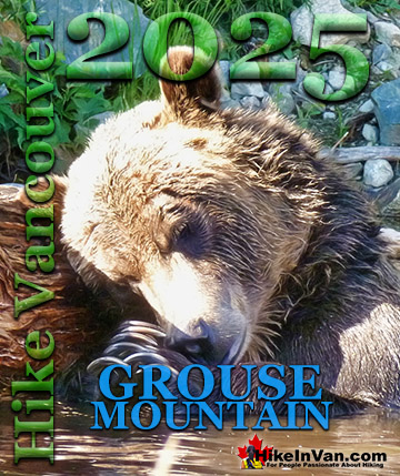
Wildlife in Garibaldi Provincial Park - Garibaldi Lake
![]() Garibaldi Lake sits in the midst of a pristine wilderness in Garibaldi Park with plenty of wildlife to see. Black bears and hoary marmots can be occasionally spotted. Black bears in the park are reclusive and not easily spotted. Hoary marmots, however, will emerge from nowhere and whistle to each other to help monitor any threats. Hoary marmots are cute, invariably pudgy, twenty plus pound ground squirrels that have evolved to live quite happily in the hostile alpine areas of much of the world. In the northwest of North America, marmots have a distinct grey in their hair, a hoary colour, so have been named hoary marmots. They manage to survive quite happily in the alpine, largely by hibernating for 8 months of the year and largely for having a surprisingly varied array of food in such an inhospitable environment. They live off of grasses, berries, lichens, mosses, and roots and flowers. And live quite well it seems, as they always look chubby, which has one great drawback. They are sought after by bears and wolves. They have a wonderful defense system though. They are constantly on watch and whistle loudly at the first sign of danger, alerting the colony. The prevalence of these "whistlers" as they came to be locally called, in the early days of London Mountain resulted in it's name being changed to Whistler Mountain in the 60's. Hiking on Whistler Mountain, Blackcomb Mountain or Wedgemount Lake in the summer will almost guarantee an encounter with a chubby, jolly little whistler hoary marmot.
Garibaldi Lake sits in the midst of a pristine wilderness in Garibaldi Park with plenty of wildlife to see. Black bears and hoary marmots can be occasionally spotted. Black bears in the park are reclusive and not easily spotted. Hoary marmots, however, will emerge from nowhere and whistle to each other to help monitor any threats. Hoary marmots are cute, invariably pudgy, twenty plus pound ground squirrels that have evolved to live quite happily in the hostile alpine areas of much of the world. In the northwest of North America, marmots have a distinct grey in their hair, a hoary colour, so have been named hoary marmots. They manage to survive quite happily in the alpine, largely by hibernating for 8 months of the year and largely for having a surprisingly varied array of food in such an inhospitable environment. They live off of grasses, berries, lichens, mosses, and roots and flowers. And live quite well it seems, as they always look chubby, which has one great drawback. They are sought after by bears and wolves. They have a wonderful defense system though. They are constantly on watch and whistle loudly at the first sign of danger, alerting the colony. The prevalence of these "whistlers" as they came to be locally called, in the early days of London Mountain resulted in it's name being changed to Whistler Mountain in the 60's. Hiking on Whistler Mountain, Blackcomb Mountain or Wedgemount Lake in the summer will almost guarantee an encounter with a chubby, jolly little whistler hoary marmot.


Parking & Trailhead Directions to Garibaldi Lake
![]() The best and closest parking lot to access Garibaldi Lake is the Rubble Creek trailhead just off of the Sea to Sky Highway, south of Whistler. The Rubble Creek trailhead parking is well equipped with direction signs, a mapboard and outhouse. The access road that connects it to the Sea to Sky Highway is paved and snowplowed in the winter. Rubble Creek is the most popular route to Garibaldi Lake and consequently the most chaotic. The huge parking lots are often filled close to capacity, with additional cars parked along the access road which can accommodate even the busiest days(so far at least, as of 2020). This road is the only paved(not a heavily potholed, gravel road) to access a trailhead to Garibaldi Lake. Though very busy, the Rubble Creek trail to Garibaldi Lake is constantly maintained to a high standard. Plenty of helpful mapboards and trail signs keep you on track and aware of where you are. The tidy, natural dirt trail is wide enough to hike side-by-side most of the time. The constant ascent from here gets you to the Garibaldi Lake in just a couple hours.
The best and closest parking lot to access Garibaldi Lake is the Rubble Creek trailhead just off of the Sea to Sky Highway, south of Whistler. The Rubble Creek trailhead parking is well equipped with direction signs, a mapboard and outhouse. The access road that connects it to the Sea to Sky Highway is paved and snowplowed in the winter. Rubble Creek is the most popular route to Garibaldi Lake and consequently the most chaotic. The huge parking lots are often filled close to capacity, with additional cars parked along the access road which can accommodate even the busiest days(so far at least, as of 2020). This road is the only paved(not a heavily potholed, gravel road) to access a trailhead to Garibaldi Lake. Though very busy, the Rubble Creek trail to Garibaldi Lake is constantly maintained to a high standard. Plenty of helpful mapboards and trail signs keep you on track and aware of where you are. The tidy, natural dirt trail is wide enough to hike side-by-side most of the time. The constant ascent from here gets you to the Garibaldi Lake in just a couple hours.

To get to Rubble Creek, drive south from Whistler Village(zero your odometer at Village Gate Boulevard) on Hwy 99. At 24.7 kilometres look for the Black Tusk(Garibaldi) sign on the highway indicating you to turn left. There is a nice, and long dedicated left turn lane on the highway here to allow you to safely exit the highway. There is a fork in the road a couple hundred metre up Daisy Lake road. Take the right fork and continue up the paved road for 2 kilometres to the Rubble Creek trailhead for Garibaldi Lake, Black Tusk, Taylor Meadows, Panorama Ridge and much more.
Directions Map to Garibaldi Lake(Rubble Creek)

Biking or Walking Directions to Garibaldi Lake
![]() Biking to the Rubble Creek trailhead for Garibaldi Lake is not realistic for most. The Cheakamus Lake trailhead, on the other hand, is just 15.1 kilometres(9.4 miles) from Whistler Village. The last 8 kilometres is a bit of a grind though as you ascend quite a bit to the Cheakamus Lake parking lot. Bikes are allowed on the Cheakamus Lake trail, so you can ride the nice and easy trail for 1.5 kilometres, park your bike, then start your hike(bikes are prohibited on the connecting trail to Black Tusk. The route to Black Tusk via the microwave tower is an excellent way to bike, then hike. In fact, biking to the microwave tower is the preferred way to get there by most. It's a bit of a long, boring hike along a gravel, deep forest road. On a bike, however, it is much quicker and riding out at the end of your trip is all down hill. The Rubble Creek trailhead is probably the least bike friendly trailhead owing to its distance from Whistler Village. 27.2 kilometres(16.9 miles) is too far for most to bike to a trailhead and begin an arduous hike!
Biking to the Rubble Creek trailhead for Garibaldi Lake is not realistic for most. The Cheakamus Lake trailhead, on the other hand, is just 15.1 kilometres(9.4 miles) from Whistler Village. The last 8 kilometres is a bit of a grind though as you ascend quite a bit to the Cheakamus Lake parking lot. Bikes are allowed on the Cheakamus Lake trail, so you can ride the nice and easy trail for 1.5 kilometres, park your bike, then start your hike(bikes are prohibited on the connecting trail to Black Tusk. The route to Black Tusk via the microwave tower is an excellent way to bike, then hike. In fact, biking to the microwave tower is the preferred way to get there by most. It's a bit of a long, boring hike along a gravel, deep forest road. On a bike, however, it is much quicker and riding out at the end of your trip is all down hill. The Rubble Creek trailhead is probably the least bike friendly trailhead owing to its distance from Whistler Village. 27.2 kilometres(16.9 miles) is too far for most to bike to a trailhead and begin an arduous hike!
Public Transit Directions to Garibaldi Lake
![]() Can you get to the Garibaldi Lake trailhead by bus from Whistler? Not even close. No bus service from Whistler will stop at the highway turnoff to Rubble Creek. The Cheakamus Lake trailhead is a possible option. The Whistler Public Transit goes between the Village and Cheakamus Crossing almost constantly. The problem of course, is you then have to hike 8 kilometres to the Cheakamus Lake trailhead. A taxi to the trailhead may be an option, however you will have to let the taxi company know where you are going as, depending on the driver, some won't drive any logging roads. Taking a taxi to the Rubble Creek trailhead is a decent option, depending on your budget. The ride will cost you about $45, each way. It does, however give you the amazing option to exit at Cheakamus Lake so you don't cover the same ground twice. If you are coming from Vancouver you do have a public transit option that is very good. ParkBus.ca will bring you from downtown Vancouver to the Rubble Creek trailhead for just $49(each way).
Can you get to the Garibaldi Lake trailhead by bus from Whistler? Not even close. No bus service from Whistler will stop at the highway turnoff to Rubble Creek. The Cheakamus Lake trailhead is a possible option. The Whistler Public Transit goes between the Village and Cheakamus Crossing almost constantly. The problem of course, is you then have to hike 8 kilometres to the Cheakamus Lake trailhead. A taxi to the trailhead may be an option, however you will have to let the taxi company know where you are going as, depending on the driver, some won't drive any logging roads. Taking a taxi to the Rubble Creek trailhead is a decent option, depending on your budget. The ride will cost you about $45, each way. It does, however give you the amazing option to exit at Cheakamus Lake so you don't cover the same ground twice. If you are coming from Vancouver you do have a public transit option that is very good. ParkBus.ca will bring you from downtown Vancouver to the Rubble Creek trailhead for just $49(each way).
More Hiking Near Garibaldi Lake
![]() Garibaldi Lake is an impressive hiking destination on its own. Beautiful, scenic trail through a deep forest to an extraordinarily vivid turquoise coloured lake. A geology lesson along the trail with the view of the ominous and potentially catastrophic rock slide, The Barrier. The enormous, crumbling wall of rock that walled off the glacier valley here thousands of years ago and allowed Garibaldi Lake to form. You could spend a whole day at Garibaldi Lake, splashing in the crystal clear water and taking in the surreal coloured lake with the enormous Sphinx Glacier at the far shore. Though Garibaldi Lake, as a hiking destination is one of the highlights of Garibaldi Park, it pales in comparison to Black Tusk and Panorama Ridge. Black Tusk with its challenging and rewarding climb to its tusk-like peak with all of Garibaldi Park sprawled out below. Black Tusk formed during the last ice age, when, as a volcano it broke through the glacier and solidified quickly. The outer rock layers crumbled away over the centuries, leaving the pure black core of the volcano that we see today. Panorama Ridge has a similarly elevated viewpoint, but unlike Black Tusk, has Garibaldi Lake filling the view below. Both views are spectacular and both are half day hikes from the campsite at Garibaldi Lake. Hiking beyond Panorama Ridge takes you to the Helm Creek trail and through some gorgeous alpine terrain before dropping quickly down to Cheakamus Lake. The Cheakamus Lake trail takes you along Cheakamus River and still more hiking trails along both sides of Cheakamus River. Next to Cheakamus River is another remnant of a volcano. Logger’s Lake is a lake that sits in a long extinct volcano. The Crater Rim trail takes you around the crumbling monster that is now a beautiful and secluded feeling lake great for swimming. Further down Cheakamus River you come to a whole network of hiking and biking trails and yet another of Whistler's surreal hiking trails, Whistler Train Wreck. Brilliantly painted, wrecked train cars litter the forest along a particularly stunning section of Cheakamus River. In a wild and deep forest you will find several mangled, yet strangely beautiful train cars.
Garibaldi Lake is an impressive hiking destination on its own. Beautiful, scenic trail through a deep forest to an extraordinarily vivid turquoise coloured lake. A geology lesson along the trail with the view of the ominous and potentially catastrophic rock slide, The Barrier. The enormous, crumbling wall of rock that walled off the glacier valley here thousands of years ago and allowed Garibaldi Lake to form. You could spend a whole day at Garibaldi Lake, splashing in the crystal clear water and taking in the surreal coloured lake with the enormous Sphinx Glacier at the far shore. Though Garibaldi Lake, as a hiking destination is one of the highlights of Garibaldi Park, it pales in comparison to Black Tusk and Panorama Ridge. Black Tusk with its challenging and rewarding climb to its tusk-like peak with all of Garibaldi Park sprawled out below. Black Tusk formed during the last ice age, when, as a volcano it broke through the glacier and solidified quickly. The outer rock layers crumbled away over the centuries, leaving the pure black core of the volcano that we see today. Panorama Ridge has a similarly elevated viewpoint, but unlike Black Tusk, has Garibaldi Lake filling the view below. Both views are spectacular and both are half day hikes from the campsite at Garibaldi Lake. Hiking beyond Panorama Ridge takes you to the Helm Creek trail and through some gorgeous alpine terrain before dropping quickly down to Cheakamus Lake. The Cheakamus Lake trail takes you along Cheakamus River and still more hiking trails along both sides of Cheakamus River. Next to Cheakamus River is another remnant of a volcano. Logger’s Lake is a lake that sits in a long extinct volcano. The Crater Rim trail takes you around the crumbling monster that is now a beautiful and secluded feeling lake great for swimming. Further down Cheakamus River you come to a whole network of hiking and biking trails and yet another of Whistler's surreal hiking trails, Whistler Train Wreck. Brilliantly painted, wrecked train cars litter the forest along a particularly stunning section of Cheakamus River. In a wild and deep forest you will find several mangled, yet strangely beautiful train cars.
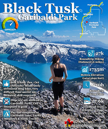
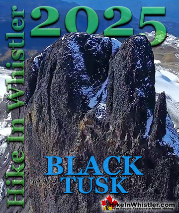
Black Tusk Hike Near Garibaldi Lake
![]() Black Tusk is the extraordinarily iconic and appropriately named mountain that can be seen from almost everywhere in Whistler. The massive black spire of crumbling rock juts out of the earth in an incredibly distinct way that appears like an enormous black tusk plunging out of the ground. Whether you spot it in the distance from the top of Whistler Mountain or from vantage points along the Sea to Sky Highway, its appearance is breathtaking. Black Tusk, created in the fires of the Garibaldi Volcanic Belt and is one of the most admired and hiked to destinations in Garibaldi Provincial Park. Every angle you look at it, from far away, to closer vantage points such as Taylor Meadows, Helm Creek, Panorama Ridge or Garibaldi Lake. All views give you the certain belief that it mus be impossible to hike to the top. In fact, Black Tusk seems to look more impossible to climb the closer you get to it. Even when you are close enough to touch its vertical, black and crumbling sides, you wonder in amazement how anyone can possible get up to the peak of this incredible mountain. Continued here...
Black Tusk is the extraordinarily iconic and appropriately named mountain that can be seen from almost everywhere in Whistler. The massive black spire of crumbling rock juts out of the earth in an incredibly distinct way that appears like an enormous black tusk plunging out of the ground. Whether you spot it in the distance from the top of Whistler Mountain or from vantage points along the Sea to Sky Highway, its appearance is breathtaking. Black Tusk, created in the fires of the Garibaldi Volcanic Belt and is one of the most admired and hiked to destinations in Garibaldi Provincial Park. Every angle you look at it, from far away, to closer vantage points such as Taylor Meadows, Helm Creek, Panorama Ridge or Garibaldi Lake. All views give you the certain belief that it mus be impossible to hike to the top. In fact, Black Tusk seems to look more impossible to climb the closer you get to it. Even when you are close enough to touch its vertical, black and crumbling sides, you wonder in amazement how anyone can possible get up to the peak of this incredible mountain. Continued here...


Panorama Ridge Hike Near Garibaldi Lake
![]() Panorama Ridge is easily one of the most amazing hikes in Garibaldi Provincial Park. The 15 kilometre(9.3 mile) hike from the trailhead at Rubble Creek to Panorama Ridge takes you through beautiful and deep forests, across countless idyllic streams, through meadows filled with flowers, and past dozens of jaw dropping viewpoints. The amazing views start once you reach Taylor Meadows and get even more spectacular as the trail progresses. Once you arrive at Panorama Ridge and its phenomenal vantage point, high above Garibaldi Park, you will stare in wonder. Mesmerized first by Garibaldi Lake, far below you and looking unnaturally blue, the lake looks amazing surrounded by green, untouched wilderness and snow capped mountains. The Table, the massive and unusual looking mountain with its bizarre flat top lays across the lake with the enormous Mount Garibaldi just beyond. In the distance, where Garibaldi Lake ends, a massive glacier rises out of the blue and jagged crevasses can be seen even from such a great distance. Behind you, Black Tusk lays across the valley. Close to the same elevation as Panorama Ridge, you get this wonderful view of it. Certainly the best and closest viewpoint to this iconic mountain. Panorama Ridge sits, along with Black Tusk in the midst of some of the most popular and beautiful hiking trails in Garibaldi Provincial Park. Continued here...
Panorama Ridge is easily one of the most amazing hikes in Garibaldi Provincial Park. The 15 kilometre(9.3 mile) hike from the trailhead at Rubble Creek to Panorama Ridge takes you through beautiful and deep forests, across countless idyllic streams, through meadows filled with flowers, and past dozens of jaw dropping viewpoints. The amazing views start once you reach Taylor Meadows and get even more spectacular as the trail progresses. Once you arrive at Panorama Ridge and its phenomenal vantage point, high above Garibaldi Park, you will stare in wonder. Mesmerized first by Garibaldi Lake, far below you and looking unnaturally blue, the lake looks amazing surrounded by green, untouched wilderness and snow capped mountains. The Table, the massive and unusual looking mountain with its bizarre flat top lays across the lake with the enormous Mount Garibaldi just beyond. In the distance, where Garibaldi Lake ends, a massive glacier rises out of the blue and jagged crevasses can be seen even from such a great distance. Behind you, Black Tusk lays across the valley. Close to the same elevation as Panorama Ridge, you get this wonderful view of it. Certainly the best and closest viewpoint to this iconic mountain. Panorama Ridge sits, along with Black Tusk in the midst of some of the most popular and beautiful hiking trails in Garibaldi Provincial Park. Continued here...

Helm Creek Hike Near Garibaldi Lake
![]() Helm Creek is a cute, meandering creek that winds its way from beyond Black Tusk, down the valley to the wonderful campground that takes its name. From the Helm Creek campground, Helm Creek descends further along the Helm Creek trail, until it joins Cheakamus River, not far from where it leaves Cheakamus Lake. The location of Helm Creek campground is pretty amazing for a variety of reasons. First it is just a great location. About halfway between Cheakamus Lake and Black Tusk it lays in some amazingly scenic areas of Garibaldi Park. Beautiful, climbable mountains all around. Amazing fields of snow that run all the way to the base of Black Tusk well into July. Rivers, creeks and waterfalls everywhere you look from the idyllic campground. A large, grassy field ringed by trees and Helm Creek. Continued...
Helm Creek is a cute, meandering creek that winds its way from beyond Black Tusk, down the valley to the wonderful campground that takes its name. From the Helm Creek campground, Helm Creek descends further along the Helm Creek trail, until it joins Cheakamus River, not far from where it leaves Cheakamus Lake. The location of Helm Creek campground is pretty amazing for a variety of reasons. First it is just a great location. About halfway between Cheakamus Lake and Black Tusk it lays in some amazingly scenic areas of Garibaldi Park. Beautiful, climbable mountains all around. Amazing fields of snow that run all the way to the base of Black Tusk well into July. Rivers, creeks and waterfalls everywhere you look from the idyllic campground. A large, grassy field ringed by trees and Helm Creek. Continued...


Cheakamus Lake Hike Near Garibaldi Lake
![]() Cheakamus Lake is a wonderfully relaxing way to get in the wilderness easily and quickly from Whistler Village. The trail begins on the far side of Whistler Mountain, 8 kilometres from the Sea to Sky Highway at Cheakamus Crossing across from Function Junction. This 8 kilometre stretch of logging road is fairly bumpy and potholed, but does have the benefit of allowing you to drive the elevation gain instead of hiking it. You can easily manage this road in a car, however carefully and very slowly in parts. Once you reach the trailhead/parking the entire 7 kilometre hiking trail to the end of the maintained Cheakamus Lake trail has barely any elevation gain. Just plenty of gradual inclines and declines along the winding route. In fact, this makes it one of the few trails in Whistler and Garibaldi Park that can boast that. The nearby Garibaldi Lake trail and the Wedgemount Lake trail make you work for the views, however, the Cheakamus Lake trail hardly makes you work at all. The trail to Cheakamus Lake takes you through an amazing forest of giant cedars that fill the forest with their amazing aroma. This forest is so packed with ancient giants that year to year the trail is adjusted by a monster of a tree fallen across the trail during some winter storm. Sometimes the trail bends around these behemoths, but more often they are laboriously chainsawed by BC Parks staff. The more enormous of these remain as fixtures of the trail. Either edging the trail or as a mighty obstacle to climb over. Continued here...
Cheakamus Lake is a wonderfully relaxing way to get in the wilderness easily and quickly from Whistler Village. The trail begins on the far side of Whistler Mountain, 8 kilometres from the Sea to Sky Highway at Cheakamus Crossing across from Function Junction. This 8 kilometre stretch of logging road is fairly bumpy and potholed, but does have the benefit of allowing you to drive the elevation gain instead of hiking it. You can easily manage this road in a car, however carefully and very slowly in parts. Once you reach the trailhead/parking the entire 7 kilometre hiking trail to the end of the maintained Cheakamus Lake trail has barely any elevation gain. Just plenty of gradual inclines and declines along the winding route. In fact, this makes it one of the few trails in Whistler and Garibaldi Park that can boast that. The nearby Garibaldi Lake trail and the Wedgemount Lake trail make you work for the views, however, the Cheakamus Lake trail hardly makes you work at all. The trail to Cheakamus Lake takes you through an amazing forest of giant cedars that fill the forest with their amazing aroma. This forest is so packed with ancient giants that year to year the trail is adjusted by a monster of a tree fallen across the trail during some winter storm. Sometimes the trail bends around these behemoths, but more often they are laboriously chainsawed by BC Parks staff. The more enormous of these remain as fixtures of the trail. Either edging the trail or as a mighty obstacle to climb over. Continued here...


Cheakamus River Hike Near Garibaldi Lake
![]() Cheakamus River is a beautiful, crashing, turquoise coloured river that flows from Cheakamus Lake, through Whistler Interpretive Forest at Cheakamus Crossing, then down past Brandywine Falls to Daisy Lake. Also a popular kayaking route, the main attraction to Cheakamus River is the wonderful and quite extensive network of hiking and biking trails that run along either side of it. The Riverside trail and the Farside trail run on either side of Cheakamus River and connect at both ends by bridges. Connecting to the Riverside trail is the short trail to Logger's Lake, which in turn is surrounded by more hiking and biking trails. The Lake Loop trail, Crater Rim trail, the Ridge trail, Upper Ridge trail, and the Lower Ridge trail. On the Farside trail along Cheakamus River you can connect to Cheakamus Road(gravel road) and hike 6 kilometres up to the Cheakamus Lake trailhead. On the other side of the neighbourhood of Cheakamus Crossing, which Cheakamus River bends around keeping the Sea to Sky Highway and train tracks on its opposite side, you find still more hiking and biking trails. Trash trail hugs the river all the way to the beautiful bridge to Whistler Train Wreck. Or, continue past the bridge to connect with the Sea to Sky trail. For the most part, however, if you are talking about the Cheakamus River trails you are likely talking about the Farside and Riverside trails in Whistler's Interpretive Forest. Continued here...
Cheakamus River is a beautiful, crashing, turquoise coloured river that flows from Cheakamus Lake, through Whistler Interpretive Forest at Cheakamus Crossing, then down past Brandywine Falls to Daisy Lake. Also a popular kayaking route, the main attraction to Cheakamus River is the wonderful and quite extensive network of hiking and biking trails that run along either side of it. The Riverside trail and the Farside trail run on either side of Cheakamus River and connect at both ends by bridges. Connecting to the Riverside trail is the short trail to Logger's Lake, which in turn is surrounded by more hiking and biking trails. The Lake Loop trail, Crater Rim trail, the Ridge trail, Upper Ridge trail, and the Lower Ridge trail. On the Farside trail along Cheakamus River you can connect to Cheakamus Road(gravel road) and hike 6 kilometres up to the Cheakamus Lake trailhead. On the other side of the neighbourhood of Cheakamus Crossing, which Cheakamus River bends around keeping the Sea to Sky Highway and train tracks on its opposite side, you find still more hiking and biking trails. Trash trail hugs the river all the way to the beautiful bridge to Whistler Train Wreck. Or, continue past the bridge to connect with the Sea to Sky trail. For the most part, however, if you are talking about the Cheakamus River trails you are likely talking about the Farside and Riverside trails in Whistler's Interpretive Forest. Continued here...


Logger's Lake Hike Near Garibaldi Lake
![]() Logger’s Lake is an amazing little lake hidden up in the deep forest above the more well known Cheakamus River. The lake, almost unbelievably exists in a long extinct volcano. However, as soon as you see the lake up close, you quickly come to believe it. The lake sits in an almost cartoonish looking, volcano-shaped bowl, with one side of the bowl a crumbling array of truck sized boulders leading down to the lake. The crater that Logger’s Lake sits in was a volcano that pushed through the glacial ice in this valley about 10000 years ago. As the lava cooled it formed the wonderful basalt ridge that is crumbling into valley. As Logger’s Lake sits deep in this ancient volcano's vent, it is sheltered from the wind and soaks up the suns rays into the dark boulders all around. As a result makes it the warmest lake in Whistler, though most other lakes around are glacier fed(via rivers and creeks), so the comparison is not entirely fair. The surrounding cliffs and forest also add to the tranquility of the lake. Located a bit off the radar for most and requiring a short logging road drive and then a very steep, but short hike to get to also contributes to its serenity. Continued here...
Logger’s Lake is an amazing little lake hidden up in the deep forest above the more well known Cheakamus River. The lake, almost unbelievably exists in a long extinct volcano. However, as soon as you see the lake up close, you quickly come to believe it. The lake sits in an almost cartoonish looking, volcano-shaped bowl, with one side of the bowl a crumbling array of truck sized boulders leading down to the lake. The crater that Logger’s Lake sits in was a volcano that pushed through the glacial ice in this valley about 10000 years ago. As the lava cooled it formed the wonderful basalt ridge that is crumbling into valley. As Logger’s Lake sits deep in this ancient volcano's vent, it is sheltered from the wind and soaks up the suns rays into the dark boulders all around. As a result makes it the warmest lake in Whistler, though most other lakes around are glacier fed(via rivers and creeks), so the comparison is not entirely fair. The surrounding cliffs and forest also add to the tranquility of the lake. Located a bit off the radar for most and requiring a short logging road drive and then a very steep, but short hike to get to also contributes to its serenity. Continued here...


Train Wreck Hike Near Garibaldi Lake
![]() The trail to Whistler Train Wreck is an easy, yet varied route through deep forest, across a great suspension bridge over Cheakamus River, to a stunning array of wrecked train cars. The trail from your car to the wrecks only takes about 15 minutes, however once you reach one wreck, you see another, then another. There are seven wrecks in total that are spread over an area about 400 metres long. Along with the surreal train wrecks painted with stunning murals, you find yourself in a thick forest that runs along Cheakamus River. Cheakamus River is a beautiful, wild and crashing river that snakes past the train wrecks. Numerous side trails take you to some marvellous viewpoints, several metres above the rushing water below. If you follow a trail past the wrecks(heading north or in the direction of Whistler Village) you will emerge at the train tracks. If you are adventurous you will then walk along, beside the tracks for a couple hundred metres and some truly breathtaking views of Cheakamus River. Continued here...
The trail to Whistler Train Wreck is an easy, yet varied route through deep forest, across a great suspension bridge over Cheakamus River, to a stunning array of wrecked train cars. The trail from your car to the wrecks only takes about 15 minutes, however once you reach one wreck, you see another, then another. There are seven wrecks in total that are spread over an area about 400 metres long. Along with the surreal train wrecks painted with stunning murals, you find yourself in a thick forest that runs along Cheakamus River. Cheakamus River is a beautiful, wild and crashing river that snakes past the train wrecks. Numerous side trails take you to some marvellous viewpoints, several metres above the rushing water below. If you follow a trail past the wrecks(heading north or in the direction of Whistler Village) you will emerge at the train tracks. If you are adventurous you will then walk along, beside the tracks for a couple hundred metres and some truly breathtaking views of Cheakamus River. Continued here...


Guides to the Best of Whistler
 No Car? No Problem! Whistler Trails
Whistler as a resort has a wonderful car-free core. The Village Stroll runs through the heart of Whistler Village and is entirely car free. If you are visiting Whistler or living here and you don't have a car, it's no problem. On foot or on a bike you can travel the extensive network of non-motorized trails. The Valley Trail snakes through Whistler Village and extends in several directions, all of which lead to beautiful parts of Whistler. The Sea to Sky Trail and the Lost Lake trails continue this massive, car-free network of trails running almost everywhere in Whistler. When it comes to many of the best hiking trails, getting to the trailheads on foot, by bike or public transit can be tricky at best or complicated and impractical at worst. Many trailheads are far from Whistler Village and... Continued here.
 Kid Friendly Whistler Hiking Trails
There are plenty of excellent, kid and family friendly hiking trails and destinations in and around Whistler. Kid and family friendly generally means an easy and somewhat short trail that a toddler can happily manage. Some of these trails are flat enough to be stroller friendly, such as Brandywine Falls, Whistler Mountain and Blackcomb Mountain. Others such as Logger’s Lake, Cheakamus River and Madeley Lake have short enough trails to reach them that you can manage with little kids that don't want to hike too far. Some of these hikes and walks are popular and close to Whistler Village, like Whistler Mountain, Blackcomb Mountain, Lost Lake Park, Rainbow Park and Meadow Park. Others are a beautiful, but far drive into the mountains and tricky to find... Continued here.
 Best Sights Sea to Sky 99
The Sea to Sky Highway links Vancouver to Whistler and has several stops along the way that are often overlooked. Porteau Cove, for example, is surprisingly unknown even to locals that have driven past hundreds of times. Just off the highway the parking area is just steps from the huge pier stretching way out over the ocean. This gigantic pier is actually a rarely used emergency dock for BC Ferries, though more often used by visitors for its stunning views of Howe Sound. Porteau Cove is an excellent pit stop on the way to Whistler, not only for the spectacular views of Howe Sound, but one of the nicest picnic spots and most convenient restrooms! Other attractions along the Sea to Sky Highway are more obvious, such as Shannon Falls, the Sea to Sky Gondola... Continued here.
 Whistler Train Wreck Murals
The colourful graffiti and murals that make Whistler Train Wreck the magical place it is today began appearing in 2011, when this hidden place was known by just a few Whistler locals. In the summer of 2011 several Whistler artists came here for "The Train Wreck Paint Jam" and transformed the mangled wreckage into a surreal art exhibit. The artists ranged from aspiring graffiti artists to professional artists like Kups. Remnants of one of his murals from 2011 is found inside the first boxcar you come to after crossing the bridge into Whistler Train Wreck. Several of the original murals were gorgeous. Brilliantly coloured and surreal in such an unusual, tranquil and hidden forest with seven mangled train boxcars scattered. Like some sort of haunting art gallery... Continued here.
 Northair Mine Murals
Way up in the Callaghan Valley on the back side of Mount Sproatt is an abandoned gold mine. Old cement foundations and two unexpectedly beautiful lakes mark the location of Northair Mine, abandoned in 1982. It was a fairly productive gold mine that extracted five tons of gold. Largely forgotten for years, in the last decade it has come to life in stunning colour by graffiti artists and professional muralists. In the summer of 2013, the first mural appeared on the blank foundation walls of Northair Mine. A creation of a professional Whistler artist PETKO. Painted on one of the inside, pillar walls, the mural is about 8 feet tall and five feet wide of what looks like a robot snake in front of a cube background. It stood out in striking contrast to the grey walls in the background... Continued here.
 Best Free Whistler Camping
Whistler is surrounded by an immense wilderness dotted with spectacular, hidden lakes and amazing places to set up a tent. Decades of logging activity has left a network of forest service roads that has opened easy access to these places. Some of these you can drive to and some you may need a 4x4 to comfortably get to. Some places to camp for free you can drive to, some require a short hike and others are fairly long hikes to reach. Beautiful Callaghan Valley is home to several incredible and free places to camp. Callaghan Lake has a great free drive-to campsite just steps from this spectacular alpine lake. If you have a canoe, you can paddle to the end of Callaghan Lake and hike the short, but steep trail up to Cirque Lake. This gorgeous lake is deep in the alpine wilderness... Continued here.
Whistler's Best Hiking Trails!
Whistler & Garibaldi Park Best Hiking by Month!

Explore BC Hiking Destinations!
Whistler Hiking Trails
Squamish Hiking Trails
Vancouver Hiking Trails
Clayoquot Hiking Trails
Victoria Hiking Trails