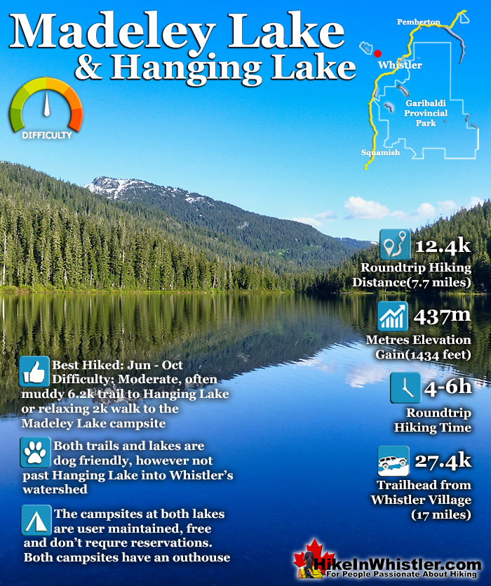
![]() Madeley Lake is a gorgeous mountain lake located high up in the Callaghan Valley just a short drive past Alexander Falls. From Whistler Village it takes about 50 minutes to drive the 27.4 kilometres to get to the parking area for both Madeley Lake and Hanging Lake. A new gate installed in 2022 blocks Madeley Lake FSR which continues two kilometres to the far end of Madeley Lake near the campsite.
Madeley Lake is a gorgeous mountain lake located high up in the Callaghan Valley just a short drive past Alexander Falls. From Whistler Village it takes about 50 minutes to drive the 27.4 kilometres to get to the parking area for both Madeley Lake and Hanging Lake. A new gate installed in 2022 blocks Madeley Lake FSR which continues two kilometres to the far end of Madeley Lake near the campsite.
 Amazing, remote feeling corner of Whistler
- Driving there is very scenic and beautiful
- Madeley has a cute beach
- Tidy & cute campsite with picnic tables & fire rings
- Beach is south facing & always sunny
- Free campsites at both lakes
- Madeley Creek flows through the campsite
- Stunning mountain views all around
- Swimming is amazing, though freezing!
 Whistler Olympic Park blocks the road
Whistler & Garibaldi Hiking
![]() Alexander Falls
Alexander Falls ![]() Ancient Cedars
Ancient Cedars ![]() Black Tusk
Black Tusk ![]() Blackcomb Mountain
Blackcomb Mountain ![]() Brandywine Falls
Brandywine Falls ![]() Brandywine Meadows
Brandywine Meadows ![]() Brew Lake
Brew Lake ![]() Callaghan Lake
Callaghan Lake ![]() Cheakamus Lake
Cheakamus Lake ![]() Cheakamus River
Cheakamus River ![]() Cirque Lake
Cirque Lake ![]() Flank Trail
Flank Trail ![]() Garibaldi Lake
Garibaldi Lake ![]() Garibaldi Park
Garibaldi Park ![]() Helm Creek
Helm Creek ![]() Jane Lakes
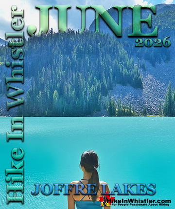
Jane Lakes ![]() Joffre Lakes
Joffre Lakes ![]() Keyhole Hot Springs
Keyhole Hot Springs ![]() Logger’s Lake
Logger’s Lake ![]() Madeley Lake
Madeley Lake ![]() Meager Hot Springs
Meager Hot Springs ![]() Nairn Falls
Nairn Falls ![]() Newt Lake
Newt Lake ![]() Panorama Ridge
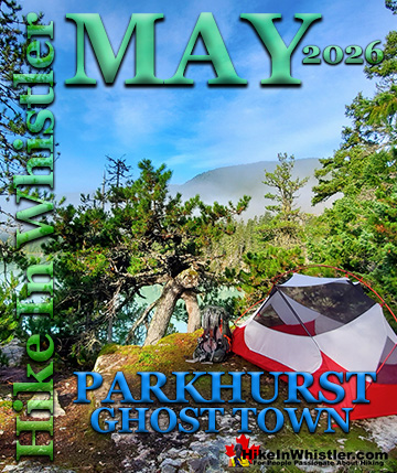
Panorama Ridge ![]() Parkhurst Ghost Town
Parkhurst Ghost Town ![]() Rainbow Falls
Rainbow Falls ![]() Rainbow Lake
Rainbow Lake ![]() Ring Lake
Ring Lake ![]() Russet Lake
Russet Lake ![]() Sea to Sky Trail
Sea to Sky Trail ![]() Skookumchuck Hot Springs
Skookumchuck Hot Springs ![]() Sloquet Hot Springs
Sloquet Hot Springs ![]() Sproatt East
Sproatt East ![]() Sproatt West
Sproatt West ![]() Taylor Meadows
Taylor Meadows ![]() Train Wreck
Train Wreck ![]() Wedgemount Lake
Wedgemount Lake ![]() Whistler Mountain
Whistler Mountain
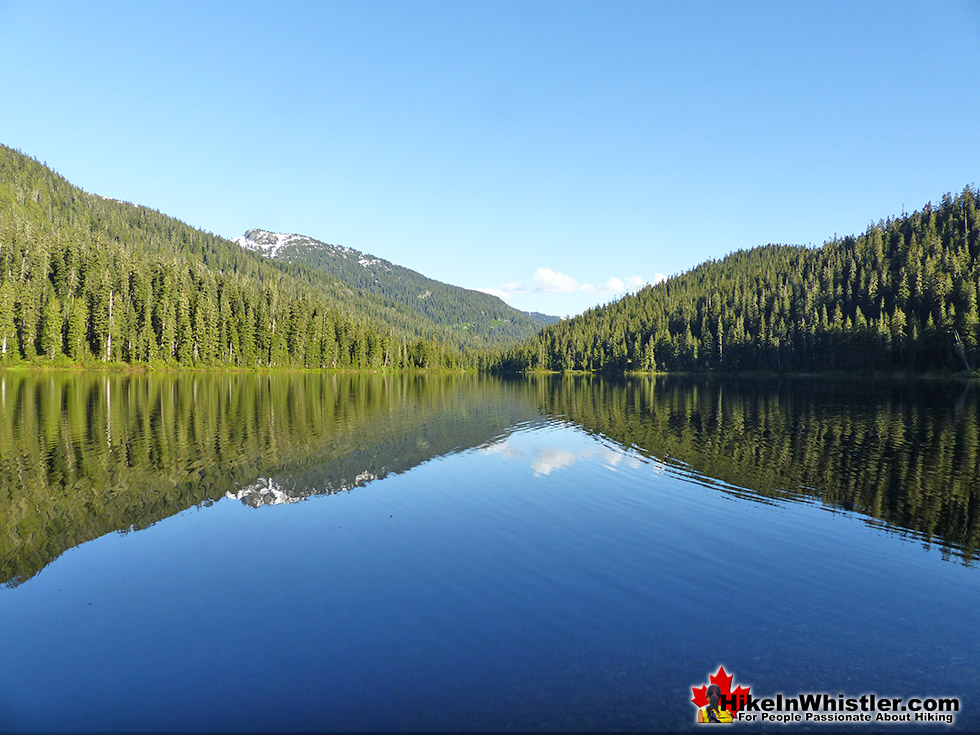
Visiting Madeley Lake now involves a boring walk up the old logging road to get there. It also makes bringing a canoe, kayak or paddleboard to the lake out of the question for most. This parking area is also where you find the trailhead for the Madeley-Hanging Lake trail. **July 2024: the bridge over Beverley Creek between Madeley Lake and Hanging Lake is out and impassable due to high water.** The Madeley-Hanging Lake trail is a moderately challenging trail that ascends through the forest for 6.2 kilometres to the free campsite at Hanging Lake. The trail connects to the Rainbow Trail, reaching Rainbow Lake in just one kilometre. At the south end of the lake, the Rainbow Trail takes you 8 kilometres down the valley to emerge at the Rainbow Trail trailhead on Alta Lake Road. These two trails meet at Rainbow Lake and the trails combined are known as the Rainbow Madeley trail, which is 16.1 kilometres long, trailhead to trailhead. Rainbow Lake is the source of much of Whistler’s water supply and therefore camping, swimming and dogs are not allowed. Hanging Lake is just outside the watershed area and none of the restrictions apply. Camping is free at the Hanging Lake campsite which is unmaintained. The campsite at Madeley Lake is also free and well outside the watershed area so there are no restrictions. Beautiful Madeley Lake is the main attraction and the trail to Hanging Lake is not very popular, especially compared to the increasingly busy Rainbow Trail which is conveniently located in Whistler off Alta Lake Road, not far from Rainbow Park. The Hanging Lake campsite is popular in the summer, though nearly everyone hikes there via the Rainbow Trail instead of the Madeley-Hanging Lake trail. Hanging Lake is nice, though Rainbow Lake and Madeley Lake are beautiful by comparison. Out of the three lakes, Madeley is the best by far in terms of scenery, serenity and size.
Beautiful Madeley Lake
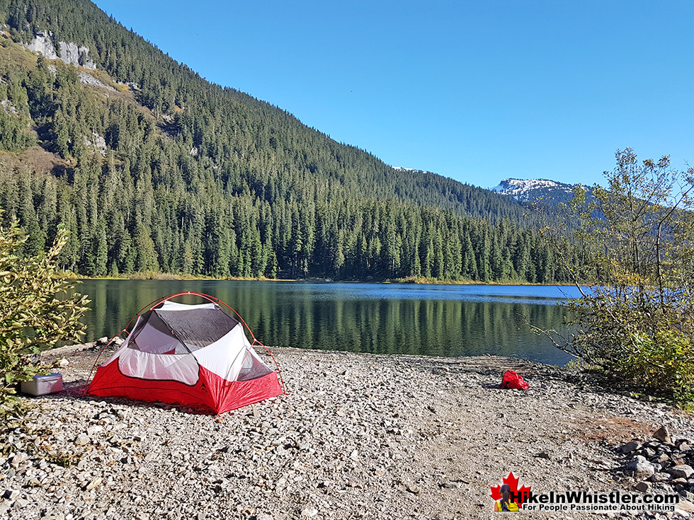
Madeley is the largest of the three lakes and situated in a south facing valley aimed directly at the sun. The small pebble beach at the far end at the campsite is amazing and always sunny. The beach slopes steeply into the lake and perfect for jumping in if you can stand the always freezing cold the glacier fed water. The campsite is spread throughout the forest behind this beach extending along the shore as well as along Madeley Creek which is filled with boulders and crisscrossed with deadfall trees. A few metal fire pits can be found in various clearings around the campsite as well as a couple of picnic tables and one very old outhouse in the forest. The campsite extends along the far end of Madeley Lake through a gorgeous and deep old forest. A trail skirts around the top of the lake and continues around the far side of the lake. The battered old trail is sometimes hard to follow, but it continues along the lake and connects to the Madeley-Hanging Lake trail just a few hundred metres from the trailhead parking area for both lakes. Most hikers avoid this section around the back side of Madeley Lake and start their hike to Hanging Lake from the trailhead at the parking area.

Madeley Lake Trail Stats:
Driving There: 50 minutes from Whistler Village(27.4 kilometres/17 miles) Hiking Distance to Madeley Lake: 500 metres to lake or 2 kilometres to campsite. Hiking Time: 20 minutes to lake or 45 minutes to campsite. Elevation Gain: Minimal Fees: None Campsites: Yes Camping Allowed: Yes Difficulty: Easy walk along Madeley FSR. Kid Friendly: Yes. Stroller Friendly: Yes. Dog Friendly: Yes
Madeley-Hanging Lake Trail Stats:
Driving There: 50 minutes from Whistler Village(27.4 kilometres/17 miles) Hiking Distance to Hanging Lake: 6.2 kilometres/3.8 miles to campsite. Hiking Time: 2-3 hours to Hanging Lake. Elevation Gain: 437 metres/1434 feet. Fees: None Campsites: Yes Camping Allowed: Yes Difficulty: Moderate, though can be challenging due to overgrown trail, deadfall, creek crossing, muddy and steep trail. Kid Friendly: Not very fun for kids. Stroller Friendly: No. Dog Friendly: Yes
Highlights of Madeley Lake and Hanging Lake
Highlights of Madeley Lake and Hanging Lake are tilted toward Madeley Lake. It is easy to get to, is wonderfully scenic, has a gorgeous, free campsite in a secluded forest. Swimming is great, though very cold. There is lots of freshwater flowing past the campsite and the forest in all directions is fun and easy to explore. The Madeley-Hanging Lake trail is not terribly nice. Not much scenery and some wet and muddy sections hard to avoid. Hanging Lake is not great, however a free campsite high up in the mountains near Whistler is fantastic. Both lakes give you that wonderful feeling of being far from civilisation and deep in the wilderness. It is not unusual to encounter no one at either lake or along the trail.
Amazing Madeley Lake Campsite Beach View

Madeley Lake Campsite

Madeley Lake Fishing

Beautiful Madeley Creek

Aerial View of the Madeley Beach

Hanging Lake in the Mountains

The Madeley-Hanging Lake Trail
![]() The Madeley-Hanging Lake trail is a 6.2 kilometre/3.8 mile route through deep forest to the Hanging Lake campsite, with an elevation gain of 437 metres/1434 feet. Madeley-Hanging Lake trail is a section of the 16.1 kilometre Rainbow Madeley Lakes trail with one end at the Rainbow Trail trailhead and the other end at the the Madeley-Hanging Lake trailhead. The trailhead sign at the start of the Rainbow Trail calls it the "Rainbow Madeley Lakes Trail - East Trailhead" and the Madeley-Hanging Lake end the "Rainbow Madeley Lakes Trail - West Trailhead". This seems appropriate, though usually the trail is done in sections with the section to Rainbow Lake being the most popular by far. This section is of course referred to as the Rainbow Lake trail or Rainbow Trail. The west end, or Madeley Lake end of the trail is usually called the Hanging Lake trail or Madeley-Hanging Lake trail.
The Madeley-Hanging Lake trail is a 6.2 kilometre/3.8 mile route through deep forest to the Hanging Lake campsite, with an elevation gain of 437 metres/1434 feet. Madeley-Hanging Lake trail is a section of the 16.1 kilometre Rainbow Madeley Lakes trail with one end at the Rainbow Trail trailhead and the other end at the the Madeley-Hanging Lake trailhead. The trailhead sign at the start of the Rainbow Trail calls it the "Rainbow Madeley Lakes Trail - East Trailhead" and the Madeley-Hanging Lake end the "Rainbow Madeley Lakes Trail - West Trailhead". This seems appropriate, though usually the trail is done in sections with the section to Rainbow Lake being the most popular by far. This section is of course referred to as the Rainbow Lake trail or Rainbow Trail. The west end, or Madeley Lake end of the trail is usually called the Hanging Lake trail or Madeley-Hanging Lake trail.
Rainbow Madeley Lakes Trail - West Trailhead Sign (Madeley-Hanging Lake Trail)

Rainbow Madeley Lakes Trail - East Trailhead Sign (Rainbow Trail)

Camping at Hanging Lake
![]()
![]() Hanging Lake is located just before Rainbow Lake. Though ugly in comparison to Rainbow Lake, Hanging Lake has a nice camping area and is dog friendly and swimming friendly. The campsite has an outhouse and several clearings for tents. Rainbow Lake is the source of Whistler's drinking water and camping, dogs, swimming and fishing are prohibited. This makes Hanging Lake is a good alternative, though the Madeley-Hanging Lake trailhead is considerably less convenient to get to than the Rainbow Trail trailhead. The watershed dividing line for dogs allowed and not allowed runs between Rainbow Lake and Hanging Lake and is marked with a huge sign. The trail from Madeley Lake to Hanging Lake is nice, however at times muddy. The access road to the Madeley-Hanging Lake trailhead is often free of snow by mid June to mid November most years, though this can vary by several weeks from year to year.
Hanging Lake is located just before Rainbow Lake. Though ugly in comparison to Rainbow Lake, Hanging Lake has a nice camping area and is dog friendly and swimming friendly. The campsite has an outhouse and several clearings for tents. Rainbow Lake is the source of Whistler's drinking water and camping, dogs, swimming and fishing are prohibited. This makes Hanging Lake is a good alternative, though the Madeley-Hanging Lake trailhead is considerably less convenient to get to than the Rainbow Trail trailhead. The watershed dividing line for dogs allowed and not allowed runs between Rainbow Lake and Hanging Lake and is marked with a huge sign. The trail from Madeley Lake to Hanging Lake is nice, however at times muddy. The access road to the Madeley-Hanging Lake trailhead is often free of snow by mid June to mid November most years, though this can vary by several weeks from year to year.
Camping at Madeley Lake
![]()
![]()
![]() The campsite at the end of Madeley Lake consists of several clearings in the forest, widely dispersed and feels wonderfully far from civilisation. The sun rises over the lake in the morning and lights up the forest which opens up to a nice little pebble beach also facing the sunshine. In previous years you could also camp at the nearby Alexander Falls, however this is no longer allowed. Also, keep in mind that this whole area in the winter is taken over by Callaghan Country and Whistler Olympic Park so access via skis comes with a usage charge. Another campsite option in the area is the beautiful and large campsite area at Callaghan Lake Provincial Park nearby. Madeley Lake, Hanging Lake and Callaghan Lake are all free of charge for camping. Madeley Lake is a wonderfully remote feeling place and the campsite is not maintained. There are a few picnic tables, an outhouse, several fire rings and several clearings for tents. Madeley Lake sits in a forgotten corner of Whistler's Callaghan Valley, and the campsite is arguably the nicest. Tranquil, great rocky beach with a crashing river flowing by. Well laid out tent sites in a deep forest, sun facing and you can drink straight from Madeley Creek which mostly comes from Telemagique Lake.
The campsite at the end of Madeley Lake consists of several clearings in the forest, widely dispersed and feels wonderfully far from civilisation. The sun rises over the lake in the morning and lights up the forest which opens up to a nice little pebble beach also facing the sunshine. In previous years you could also camp at the nearby Alexander Falls, however this is no longer allowed. Also, keep in mind that this whole area in the winter is taken over by Callaghan Country and Whistler Olympic Park so access via skis comes with a usage charge. Another campsite option in the area is the beautiful and large campsite area at Callaghan Lake Provincial Park nearby. Madeley Lake, Hanging Lake and Callaghan Lake are all free of charge for camping. Madeley Lake is a wonderfully remote feeling place and the campsite is not maintained. There are a few picnic tables, an outhouse, several fire rings and several clearings for tents. Madeley Lake sits in a forgotten corner of Whistler's Callaghan Valley, and the campsite is arguably the nicest. Tranquil, great rocky beach with a crashing river flowing by. Well laid out tent sites in a deep forest, sun facing and you can drink straight from Madeley Creek which mostly comes from Telemagique Lake.

Restrictions and Concerns at Madeley Lake
![]() There are not really any restrictions at Madeley Lake. Free camping, dog friendly, and fires are OK in the fire rings. Though during dry periods in the summertime, you will see a "no fires" sign in the campground. The Madeley-Hanging Lake trail is very dog friendly but keep in mind that it is often a muddy, so your car will get muddy if you don't take him for a swim at the end. Beyond Hanging Lake you will come to a large sign indicating that Rainbow Lake is Whistler's water source and dogs, swimming, fishing, etc are prohibited. There are plenty of other dog friendly trails around Whistler.
There are not really any restrictions at Madeley Lake. Free camping, dog friendly, and fires are OK in the fire rings. Though during dry periods in the summertime, you will see a "no fires" sign in the campground. The Madeley-Hanging Lake trail is very dog friendly but keep in mind that it is often a muddy, so your car will get muddy if you don't take him for a swim at the end. Beyond Hanging Lake you will come to a large sign indicating that Rainbow Lake is Whistler's water source and dogs, swimming, fishing, etc are prohibited. There are plenty of other dog friendly trails around Whistler.
Wildlife at Madeley Lake
![]() Lots of black bears inhabit the forest around Madeley Lake and the Callaghan Valley. So many that you will occasionally see a bear watching tour across the lake. They drive up Callaghan Valley road and then up to Madeley Lake. Often seeing multiple bears on the drive to the lake. The Callaghan Valley is also home to grizzly bears. Occasionally you hear of someone photographing a grizzly bear in the area. If you encounter a black bear, don't worry too much as they are rarely aggressive in Whistler. If you encounter a grizzly bear, you should be worried. Though sightings are rare and there has never been a grizzly bear attack, or unprovoked black bear attack in Whistler, it is still possible. Much more so than an encounter with a black bear. Black bears are timid and fearful of humans, whereas grizzly bears are far more likely to become aggressive if you get in their space. The worrying thing about grizzly bears is though you are extremely unlikely to ever see one in and around Whistler, if you do happen upon one, you will be in a lot of danger if it is inclined to find you a threat.
Lots of black bears inhabit the forest around Madeley Lake and the Callaghan Valley. So many that you will occasionally see a bear watching tour across the lake. They drive up Callaghan Valley road and then up to Madeley Lake. Often seeing multiple bears on the drive to the lake. The Callaghan Valley is also home to grizzly bears. Occasionally you hear of someone photographing a grizzly bear in the area. If you encounter a black bear, don't worry too much as they are rarely aggressive in Whistler. If you encounter a grizzly bear, you should be worried. Though sightings are rare and there has never been a grizzly bear attack, or unprovoked black bear attack in Whistler, it is still possible. Much more so than an encounter with a black bear. Black bears are timid and fearful of humans, whereas grizzly bears are far more likely to become aggressive if you get in their space. The worrying thing about grizzly bears is though you are extremely unlikely to ever see one in and around Whistler, if you do happen upon one, you will be in a lot of danger if it is inclined to find you a threat.

History of Madeley Lake
![]() Why is Madeley Lake sometimes mislabelled Powell Lake on some maps, including Google maps? Most maps show it correctly as Madeley Lake and the forest service road to get there is signed as the Madeley Lake FSR. Madeley Lake has been locally known by that name in recent memory as well as identified at Madeley Lake in many Forest Service records. Madeley Lake is named as a memorial to remember Canadian Army Lieutenant William A. Madeley, from Squamish; killed in action 15 June 1945. This would indicate the name was established in 1945 or soon after. The origin of the Powell Lake name is from a brief period of time in the 1970's when a mining company worked the area. The Lakewood Mining Company discovered a high tungsten geochemistry in the west shore of Madeley Lake. An extremely rare, yellow fluorescent material named powellite. The Lakewood Mining Company geologists referred to Madeley Lake as Powell Lake. Around the lake itself, signs and mapboards show it as Madeley Lake, which seems to reinforce this name as the correct, and official name to use despite Google's continued use of Powell Lake.
Why is Madeley Lake sometimes mislabelled Powell Lake on some maps, including Google maps? Most maps show it correctly as Madeley Lake and the forest service road to get there is signed as the Madeley Lake FSR. Madeley Lake has been locally known by that name in recent memory as well as identified at Madeley Lake in many Forest Service records. Madeley Lake is named as a memorial to remember Canadian Army Lieutenant William A. Madeley, from Squamish; killed in action 15 June 1945. This would indicate the name was established in 1945 or soon after. The origin of the Powell Lake name is from a brief period of time in the 1970's when a mining company worked the area. The Lakewood Mining Company discovered a high tungsten geochemistry in the west shore of Madeley Lake. An extremely rare, yellow fluorescent material named powellite. The Lakewood Mining Company geologists referred to Madeley Lake as Powell Lake. Around the lake itself, signs and mapboards show it as Madeley Lake, which seems to reinforce this name as the correct, and official name to use despite Google's continued use of Powell Lake.
Getting to Madeley Lake
![]()
![]()
![]() Biking and public transit options to get to Madeley Lake are not good. Far away from any bus routes, you may be able to make your way to Whistler Olympic Park by a local tour or taxi, but then you still have a fair distance to hike to the lake. Driving to Madeley Lake is the only realistic and convenient option for most. From Whistler drive 13.8 kilometres towards Vancouver on the Sea to Sky highway, then turn right at the sign for Whistler Olympic Park. Drive up the beautiful, winding road for 9.6 kilometres. The sign for Callaghan Lake will be just after Alexander Falls and just before Whistler Olympic Park, you will turn left, cross a bridge and after about 300 metres turn right onto another logging road(Madeley Lake FSR). You may want to zero your odometer here again because in 700 metres there is a fork in the road that you have to bear left. At 900 metres you will drive past the rock quarry on your left. At 2.4km you will come to another fork in the road, keep to the right and continue straight. At 4.2km the road will end at the new gate Whistler Olympic Park installed in 2022 at the Hanging Lake trailhead parking area. The campsite at Madeley Lake is about 2 kilometres from this new gate. **the access road to Madeley Lake is often impassable due to snow until mid June. In 2018, June 12th was the first day a high clearance 4x4 made it through the last deep snow section about 1 kilometre from the lake. Most SUV's managed to get through by about the 16th of June. Cars had to wait until late June to get through.
Biking and public transit options to get to Madeley Lake are not good. Far away from any bus routes, you may be able to make your way to Whistler Olympic Park by a local tour or taxi, but then you still have a fair distance to hike to the lake. Driving to Madeley Lake is the only realistic and convenient option for most. From Whistler drive 13.8 kilometres towards Vancouver on the Sea to Sky highway, then turn right at the sign for Whistler Olympic Park. Drive up the beautiful, winding road for 9.6 kilometres. The sign for Callaghan Lake will be just after Alexander Falls and just before Whistler Olympic Park, you will turn left, cross a bridge and after about 300 metres turn right onto another logging road(Madeley Lake FSR). You may want to zero your odometer here again because in 700 metres there is a fork in the road that you have to bear left. At 900 metres you will drive past the rock quarry on your left. At 2.4km you will come to another fork in the road, keep to the right and continue straight. At 4.2km the road will end at the new gate Whistler Olympic Park installed in 2022 at the Hanging Lake trailhead parking area. The campsite at Madeley Lake is about 2 kilometres from this new gate. **the access road to Madeley Lake is often impassable due to snow until mid June. In 2018, June 12th was the first day a high clearance 4x4 made it through the last deep snow section about 1 kilometre from the lake. Most SUV's managed to get through by about the 16th of June. Cars had to wait until late June to get through.

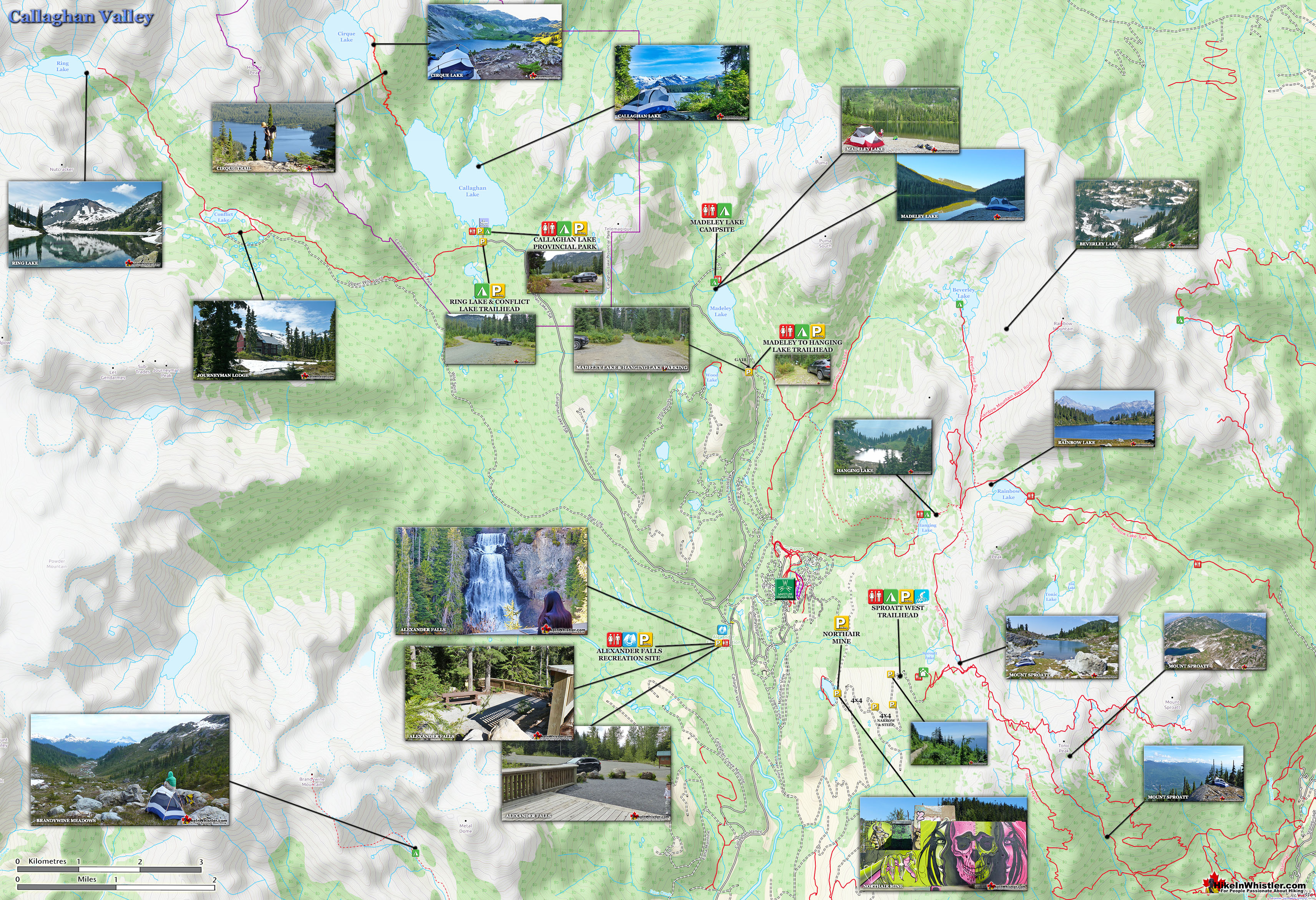
Hikes and Sights Near Madeley Lake
![]() Madeley Lake is located high up in Callaghan Valley. This enormous, wild and beautiful valley is surrounded by mountains and a variety of gorgeous mountains, lakes, waterfalls, glaciers and hiking trails. Callaghan Lake Provincial Park is located up the logging road you would have turned off of to drive up to Madeley Lake. Callaghan Lake is a large and very tranquil lake in a pristine forest surrounded by snowy mountains. The small campsite is right on the shore of the lake and you can drive right to the edge of the water. Canoeing on Callaghan Lake is about as peaceful an experience you can get as you often have the entire lake and surrounding wilderness to yourself. Sometimes the campsite gets busy, but rarely the lake. At the far end of the lake is the unmarked and hard to spot trailhead to Cirque Lake, an even more remote and idyllic lake. Steep sided, almost like a large volcano's crater, Cirque Lake is a little corner of paradise far removed from the increasingly chaotic Garibaldi Park across the valley. Back at Madeley Lake you will find the Madeley to Hanging Lake trail. Hanging Lake is a good place to camp as you cannot camp in the watershed around Rainbow Lake, which Hanging Lake is close to. Rainbow Lake is where Whistler's water supply comes from and though you cannot camp in the watershed, the hiking is terrific. The Rainbow Trail starts down in the Whistler Valley, not far from Rainbow Park on Alta Lake.
Madeley Lake is located high up in Callaghan Valley. This enormous, wild and beautiful valley is surrounded by mountains and a variety of gorgeous mountains, lakes, waterfalls, glaciers and hiking trails. Callaghan Lake Provincial Park is located up the logging road you would have turned off of to drive up to Madeley Lake. Callaghan Lake is a large and very tranquil lake in a pristine forest surrounded by snowy mountains. The small campsite is right on the shore of the lake and you can drive right to the edge of the water. Canoeing on Callaghan Lake is about as peaceful an experience you can get as you often have the entire lake and surrounding wilderness to yourself. Sometimes the campsite gets busy, but rarely the lake. At the far end of the lake is the unmarked and hard to spot trailhead to Cirque Lake, an even more remote and idyllic lake. Steep sided, almost like a large volcano's crater, Cirque Lake is a little corner of paradise far removed from the increasingly chaotic Garibaldi Park across the valley. Back at Madeley Lake you will find the Madeley to Hanging Lake trail. Hanging Lake is a good place to camp as you cannot camp in the watershed around Rainbow Lake, which Hanging Lake is close to. Rainbow Lake is where Whistler's water supply comes from and though you cannot camp in the watershed, the hiking is terrific. The Rainbow Trail starts down in the Whistler Valley, not far from Rainbow Park on Alta Lake.

Alexander Falls Near Madeley Lake
![]() Alexander Falls is a very impressive 43 metre/141 foot waterfall just 30 to 40 minutes south of Whistler in the Callaghan Valley. Open year-round and located just before Whistler Olympic Park where several of the 2010 Olympic events were held. There is a nice viewing platform on the edge of the cliff across from the falls which crash fantastically into the valley below. The parking area and viewing platform at Alexander Falls is one big area just 40 metres from the main road, just before Whistler Olympic Park. The adventurous can find the obscure trail that leads to both the top of the falls as well as, with great difficulty, to the base of the falls. Alexander Falls is certainly one of the nicest spots for a picnic in Whistler. The picnic areas are numerous, the surrounding forest is gorgeous and wild and Alexander Falls crashes loud and beautiful in the background. Continued here...
Alexander Falls is a very impressive 43 metre/141 foot waterfall just 30 to 40 minutes south of Whistler in the Callaghan Valley. Open year-round and located just before Whistler Olympic Park where several of the 2010 Olympic events were held. There is a nice viewing platform on the edge of the cliff across from the falls which crash fantastically into the valley below. The parking area and viewing platform at Alexander Falls is one big area just 40 metres from the main road, just before Whistler Olympic Park. The adventurous can find the obscure trail that leads to both the top of the falls as well as, with great difficulty, to the base of the falls. Alexander Falls is certainly one of the nicest spots for a picnic in Whistler. The picnic areas are numerous, the surrounding forest is gorgeous and wild and Alexander Falls crashes loud and beautiful in the background. Continued here...

Callaghan Lake - Hikes Near Madeley Lake
![]() Callaghan Lake Provincial Park is a relatively untouched wilderness of rugged mountainous terrain. The valley walls were formed by relatively recent glaciation. Evidence of this can be seen in the considerable glacial till and slide materials visible across the lake. Around the lake you will see talus slopes, flat rock benches, cirques, hanging valleys, tarns, waterfalls and upland plateaus with bogs. The wildlife that reside in the area include bobcats, cougars, coyotes, minks, wolverines, wolves, bears, deer, mountain goats and occasionally moose and grizzly bears. Callaghan Lake is not really a hiking destination but more of a drive to campsite on a beautiful lake, and gateway to some beautiful intermediate hikes. The campsite is small and looks a bit like a parking lot with about a dozen spots to put up a tent near your vehicle. There is a small boat launch at the campsite and the lake is large and beautiful to paddle. Surrounded by snowy mountains and nice rock outcrops the lake is good for fishing. The hiking trails are minimal here due to the steepness and deep forest surrounding the lake. From the main parking area some short trails extend in either direction. Continued here...
Callaghan Lake Provincial Park is a relatively untouched wilderness of rugged mountainous terrain. The valley walls were formed by relatively recent glaciation. Evidence of this can be seen in the considerable glacial till and slide materials visible across the lake. Around the lake you will see talus slopes, flat rock benches, cirques, hanging valleys, tarns, waterfalls and upland plateaus with bogs. The wildlife that reside in the area include bobcats, cougars, coyotes, minks, wolverines, wolves, bears, deer, mountain goats and occasionally moose and grizzly bears. Callaghan Lake is not really a hiking destination but more of a drive to campsite on a beautiful lake, and gateway to some beautiful intermediate hikes. The campsite is small and looks a bit like a parking lot with about a dozen spots to put up a tent near your vehicle. There is a small boat launch at the campsite and the lake is large and beautiful to paddle. Surrounded by snowy mountains and nice rock outcrops the lake is good for fishing. The hiking trails are minimal here due to the steepness and deep forest surrounding the lake. From the main parking area some short trails extend in either direction. Continued here...


Cirque Lake - Hikes Near Madeley Lake
![]() Cirque Lake is a wild and beautiful lake that hides high above and beyond Callaghan Lake in Callaghan Lake Provincial Park. What makes Cirque Lake special among the other sensationally beautiful lakes in the Whistler area is both its location and geologically formed shape. It sits high above Callaghan Lake, which itself is a gorgeous, mountain lake. The remoteness of Callaghan Lake is a bit of a mirage due to the fact that you can drive right to it! Callaghan Lake is accessible via an 8 kilometre weather battered and very potholed forest service road. The entire road is cratered with deep potholes, cut by frequent cross-ditches, and more recently a small section collapsing into the valley below. This logging road begins high up in the Callaghan Valley, which itself is largely overlooked by travellers to Whistler. The Callaghan Valley is home to quite a few natural and man-made attractions. Brandywine Meadows, Alexander Falls, Northair Mine and Mount Sproatt are all found in the valley. Though Cirque Lake appears far up into the wilderness, the amount of hiking required to reach it is only about two kilometres. Also, two kilometres of canoeing is required to reach the trailhead at the far end of Callaghan Lake. But for such an enchantingly beautiful, mountain lake, the exertion to reach it is remarkably little. The other attribute of Cirque Lake that makes it special, is its cirque structure. From the moment you catch sight of Cirque Lake, the abruptly steep sides all around give you the humbling feeling that you are inside a volcano. A volcano filled with emerald water and ringed by grassy meadows and crumbling, near vertical cliffs. Cirque Lake is not formed out of an extinct volcano, but rather a depression in the north side of Mount Callaghan carved out by a glacier. This fairly common phenomenon is called a cirque, and Cirque Lake is a beautiful example of one and the reason for its name. Beautiful Cirque Lake continued here...
Cirque Lake is a wild and beautiful lake that hides high above and beyond Callaghan Lake in Callaghan Lake Provincial Park. What makes Cirque Lake special among the other sensationally beautiful lakes in the Whistler area is both its location and geologically formed shape. It sits high above Callaghan Lake, which itself is a gorgeous, mountain lake. The remoteness of Callaghan Lake is a bit of a mirage due to the fact that you can drive right to it! Callaghan Lake is accessible via an 8 kilometre weather battered and very potholed forest service road. The entire road is cratered with deep potholes, cut by frequent cross-ditches, and more recently a small section collapsing into the valley below. This logging road begins high up in the Callaghan Valley, which itself is largely overlooked by travellers to Whistler. The Callaghan Valley is home to quite a few natural and man-made attractions. Brandywine Meadows, Alexander Falls, Northair Mine and Mount Sproatt are all found in the valley. Though Cirque Lake appears far up into the wilderness, the amount of hiking required to reach it is only about two kilometres. Also, two kilometres of canoeing is required to reach the trailhead at the far end of Callaghan Lake. But for such an enchantingly beautiful, mountain lake, the exertion to reach it is remarkably little. The other attribute of Cirque Lake that makes it special, is its cirque structure. From the moment you catch sight of Cirque Lake, the abruptly steep sides all around give you the humbling feeling that you are inside a volcano. A volcano filled with emerald water and ringed by grassy meadows and crumbling, near vertical cliffs. Cirque Lake is not formed out of an extinct volcano, but rather a depression in the north side of Mount Callaghan carved out by a glacier. This fairly common phenomenon is called a cirque, and Cirque Lake is a beautiful example of one and the reason for its name. Beautiful Cirque Lake continued here...


Ring Lake - Hikes Near Madeley Lake
![]() Ring Lake is a fantastically serene and wonderfully remote lake similar to Cirque Lake, but considerably farther to hike to reach it. The 10 kilometre(6.2 mile) hike takes you through a rarely hiked forest, then to an idyllic meadow filled with ponds and ringed with distant, mountains, then finally up an over some steep terrain to reveal this very hidden lake. 5 kilometres(3.1 miles) into the hike you come to Conflict Lake with trails running around it. Journeyman Lodge sits near Conflict Lake. A wilderness lodge operated by Callaghan Country, a tour company that operates in the valley. They offer a range of alpine activities, far more serene than across the valley on Whistler Mountain and Blackcomb Mountain. Signs along the trail and at Conflict Lake indicate which trail to take to reach Ring Lake, a further 5 kilometres from Conflict Lake. The trail from Conflict Lake to Ring Lake passes through a huge valley for a couple kilometres, then abruptly ascends on the right side of the valley. The trail is poorly marked in this section and you have to keep bearing right to avoid descending back into the valley. The trail is occasionally maintained, however owing to heavy winter snow, the trail gets pretty brutalized every winter. Because of the winter destruction, the visible trail in some parts disappears and you find yourself wondering if you are still on your way to Ring Lake. The key to staying on the right route, you quickly figure out, is to keep to the right side of the valley. Three kilometres of, at times very steep, but not technical trail gets you to the magnificent Ring Lake and the imposing Ring Mountain across the emerald green water. Continued here...
Ring Lake is a fantastically serene and wonderfully remote lake similar to Cirque Lake, but considerably farther to hike to reach it. The 10 kilometre(6.2 mile) hike takes you through a rarely hiked forest, then to an idyllic meadow filled with ponds and ringed with distant, mountains, then finally up an over some steep terrain to reveal this very hidden lake. 5 kilometres(3.1 miles) into the hike you come to Conflict Lake with trails running around it. Journeyman Lodge sits near Conflict Lake. A wilderness lodge operated by Callaghan Country, a tour company that operates in the valley. They offer a range of alpine activities, far more serene than across the valley on Whistler Mountain and Blackcomb Mountain. Signs along the trail and at Conflict Lake indicate which trail to take to reach Ring Lake, a further 5 kilometres from Conflict Lake. The trail from Conflict Lake to Ring Lake passes through a huge valley for a couple kilometres, then abruptly ascends on the right side of the valley. The trail is poorly marked in this section and you have to keep bearing right to avoid descending back into the valley. The trail is occasionally maintained, however owing to heavy winter snow, the trail gets pretty brutalized every winter. Because of the winter destruction, the visible trail in some parts disappears and you find yourself wondering if you are still on your way to Ring Lake. The key to staying on the right route, you quickly figure out, is to keep to the right side of the valley. Three kilometres of, at times very steep, but not technical trail gets you to the magnificent Ring Lake and the imposing Ring Mountain across the emerald green water. Continued here...


Rainbow Lake - Hikes Near Madeley Lake
![]() Rainbow Lake is one of the original hiking trails in Whistler that has existed well before Whistler was called Whistler. The 8 kilometre trail is challenging though beautiful as it passes through an impressively huge forest of giant trees. There are several wonderful bridge crossings and crashing river views. Rainbow Lake itself is surreal and beautiful. An unnaturally bright, green meadow extends from one side of the lake and a field of starkly white erratics litter the landscape along the shores of the crystal clear lake. Rainbow Lake is Whistler's water source so swimming, fishing, dogs and camping are not allowed. There are, you will quickly notice upon reaching Rainbow Lake, that a trail continues past the lake then forks. If you hiked up from the Madeley Lake trail to Hanging Lake, Rainbow Lake is just a 20 minute hike past Hanging Lake. The Rainbow Trail is a convenient and popular trail near Whistler Village that takes you to Rainbow Lake as well as the Rainbow-Sproatt Flank Trail, Rainbow Falls, Hanging Lake, Madeley Lake, Beverley Lake, Rainbow Mountain... and even Whistler Olympic Park if you are determined. It is a consistently uphill and very beautiful trail with several water (bridge) crossings and waterfalls on the way to the picture-perfect lake. There are a few views of the valley across to Whistler Mountain, Blackcomb Mountain, and Wedge Mountain. Few views, though fantastic. Rainbow Lake itself is in a gorgeous alpine valley with branching trails that extend further beyond the lake in at least three directions. Along with the waterfalls, bridge crossings and valley views, the Rainbow Trail passes through deep forest with some impressively huge trees. Continued here...
Rainbow Lake is one of the original hiking trails in Whistler that has existed well before Whistler was called Whistler. The 8 kilometre trail is challenging though beautiful as it passes through an impressively huge forest of giant trees. There are several wonderful bridge crossings and crashing river views. Rainbow Lake itself is surreal and beautiful. An unnaturally bright, green meadow extends from one side of the lake and a field of starkly white erratics litter the landscape along the shores of the crystal clear lake. Rainbow Lake is Whistler's water source so swimming, fishing, dogs and camping are not allowed. There are, you will quickly notice upon reaching Rainbow Lake, that a trail continues past the lake then forks. If you hiked up from the Madeley Lake trail to Hanging Lake, Rainbow Lake is just a 20 minute hike past Hanging Lake. The Rainbow Trail is a convenient and popular trail near Whistler Village that takes you to Rainbow Lake as well as the Rainbow-Sproatt Flank Trail, Rainbow Falls, Hanging Lake, Madeley Lake, Beverley Lake, Rainbow Mountain... and even Whistler Olympic Park if you are determined. It is a consistently uphill and very beautiful trail with several water (bridge) crossings and waterfalls on the way to the picture-perfect lake. There are a few views of the valley across to Whistler Mountain, Blackcomb Mountain, and Wedge Mountain. Few views, though fantastic. Rainbow Lake itself is in a gorgeous alpine valley with branching trails that extend further beyond the lake in at least three directions. Along with the waterfalls, bridge crossings and valley views, the Rainbow Trail passes through deep forest with some impressively huge trees. Continued here...


Northair Mine Near Madeley Lake
![]() Northair Mine is a surreal little world of colourful murals on abandoned cement foundations, surrounded by an astoundingly tranquil little lake in a secluded forest. Just a short logging road off of the Callaghan Valley Road takes you to this unusual little abandoned mine. You would have driven by the turnoff if you have been to Whistler Olympic Park or Alexander Falls, both of which are just a couple kilometres away. Northair Mine gets its name from the Vancouver based mining company the Northair Group. The mine was in production from 1976 and extracted 5 tons of gold before being abandoned in 1982. Today it is a bizarre little world in the mountains that has become an incredible place to escape the world and camp out under the stars. Northair Mine is tricky to find and even when you near it, the turnoff is not obvious. The access road takes you high into the mountains and is only free of snow in May most years. In 2016, for example, the snow melted enough for vehicle access during the first week in May. Driving to Northair Mine is along a bumpy, potholed, old logging road drivable by most vehicles, though at least one deep washout may give even SUV's some difficulty. Once Northair Mine comes into view it is quite a sight. The area that surrounds the old ruins is unexpectedly huge. About 2 kilometres long, edged by a cliff on one side and a beautiful lake on the other. Graffiti art covers some of the cement pilings and scattered remnants indicate that this skeleton of a building has been home to its share of gatherings since being abandoned. Whistler's cherished Flank Trail passes right by Northair Mine near its terminus at Whistler Olympic Park. Although, the Rainbow-Sproatt Flank Trail effectively ends far south of the Northair Mine, it piggybacks on the logging road that extends up and past the mine. With the massive construction that preceded the 2010 Olympics, the Callaghan Valley had a luxuriously wide, paved road built high up into the mountains here. Northair Mine continued here..
Northair Mine is a surreal little world of colourful murals on abandoned cement foundations, surrounded by an astoundingly tranquil little lake in a secluded forest. Just a short logging road off of the Callaghan Valley Road takes you to this unusual little abandoned mine. You would have driven by the turnoff if you have been to Whistler Olympic Park or Alexander Falls, both of which are just a couple kilometres away. Northair Mine gets its name from the Vancouver based mining company the Northair Group. The mine was in production from 1976 and extracted 5 tons of gold before being abandoned in 1982. Today it is a bizarre little world in the mountains that has become an incredible place to escape the world and camp out under the stars. Northair Mine is tricky to find and even when you near it, the turnoff is not obvious. The access road takes you high into the mountains and is only free of snow in May most years. In 2016, for example, the snow melted enough for vehicle access during the first week in May. Driving to Northair Mine is along a bumpy, potholed, old logging road drivable by most vehicles, though at least one deep washout may give even SUV's some difficulty. Once Northair Mine comes into view it is quite a sight. The area that surrounds the old ruins is unexpectedly huge. About 2 kilometres long, edged by a cliff on one side and a beautiful lake on the other. Graffiti art covers some of the cement pilings and scattered remnants indicate that this skeleton of a building has been home to its share of gatherings since being abandoned. Whistler's cherished Flank Trail passes right by Northair Mine near its terminus at Whistler Olympic Park. Although, the Rainbow-Sproatt Flank Trail effectively ends far south of the Northair Mine, it piggybacks on the logging road that extends up and past the mine. With the massive construction that preceded the 2010 Olympics, the Callaghan Valley had a luxuriously wide, paved road built high up into the mountains here. Northair Mine continued here..

Mount Sproatt - Hikes Near Madeley Lake
![]() Mount Sproatt, or as it is known locally as just Sproatt, is one of the many towering mountains visible from Whistler Village. Above and beyond Alta Lake, directly across from Whistler Mountain and Blackcomb Mountain, you will see this quiet giant. Its unremarkable appearance hides the growing network of trails that stretch through some startlingly beautiful terrain. Next time you walk through Whistler Village and cross the pedestrian bridge(with Village Gate Boulevard below you), you will see Mount Sproatt in the distance. It is the rocky giant, abruptly steep on one end and gently sloping on the other. At its summit you may be able to make out the small weather recording structure. What you can't see from Whistler Village is the extraordinarily beautiful alpine paradise that lays beyond it. Lakes and tarns everywhere you look. Fields of alpine flowers and wonderfully mangled, yet strikingly beautiful forests of krummholz. Hostile looking fields of boulders and absurdly placed erratics the size of RV's. Beyond, of course, endless stunning view of distant, snowy mountains. From the towering elevation of much of the Mount Sproatt hiking trail network, you often look across or even down on distant mountains. Sproatt West trail continued here...
Mount Sproatt, or as it is known locally as just Sproatt, is one of the many towering mountains visible from Whistler Village. Above and beyond Alta Lake, directly across from Whistler Mountain and Blackcomb Mountain, you will see this quiet giant. Its unremarkable appearance hides the growing network of trails that stretch through some startlingly beautiful terrain. Next time you walk through Whistler Village and cross the pedestrian bridge(with Village Gate Boulevard below you), you will see Mount Sproatt in the distance. It is the rocky giant, abruptly steep on one end and gently sloping on the other. At its summit you may be able to make out the small weather recording structure. What you can't see from Whistler Village is the extraordinarily beautiful alpine paradise that lays beyond it. Lakes and tarns everywhere you look. Fields of alpine flowers and wonderfully mangled, yet strikingly beautiful forests of krummholz. Hostile looking fields of boulders and absurdly placed erratics the size of RV's. Beyond, of course, endless stunning view of distant, snowy mountains. From the towering elevation of much of the Mount Sproatt hiking trail network, you often look across or even down on distant mountains. Sproatt West trail continued here...


Guides to the Best of Whistler

Best Free Whistler Camping
Whistler is surrounded by an immense wilderness dotted with spectacular, hidden lakes and amazing places to set up a tent. Decades of logging activity has left a network of forest service roads that has opened easy access to these places. Some of these you can drive to and some you may need a 4x4 to comfortably get to. Some places to camp for free you can drive to, some require a short hike and others are fairly long hikes to reach. Beautiful Callaghan Valley is home to several incredible and free places to camp. Callaghan Lake has a great free drive-to campsite just steps from this spectacular alpine lake. If you have a canoe, you can paddle to the end of Callaghan Lake and hike the short, but steep trail up to Cirque Lake. This gorgeous lake is deep in the alpine wilderness... Continued here.
 Northair Mine Murals
Way up in the Callaghan Valley on the back side of Mount Sproatt is an abandoned gold mine. Old cement foundations and two unexpectedly beautiful lakes mark the location of Northair Mine, abandoned in 1982. It was a fairly productive gold mine that extracted five tons of gold. Largely forgotten for years, in the last decade it has come to life in stunning colour by graffiti artists and professional muralists. In the summer of 2013, the first mural appeared on the blank foundation walls of Northair Mine. A creation of a professional Whistler artist PETKO. Painted on one of the inside, pillar walls, the mural is about 8 feet tall and five feet wide of what looks like a robot snake in front of a cube background. It stood out in striking contrast to the grey walls in the background... Continued here.
 Kid Friendly Whistler Hiking Trails
There are plenty of excellent, kid and family friendly hiking trails and destinations in and around Whistler. Kid and family friendly generally means an easy and somewhat short trail that a toddler can happily manage. Some of these trails are flat enough to be stroller friendly, such as Brandywine Falls, Whistler Mountain and Blackcomb Mountain. Others such as Logger’s Lake, Cheakamus River and Madeley Lake have short enough trails to reach them that you can manage with little kids that don't want to hike too far. Some of these hikes and walks are popular and close to Whistler Village, like Whistler Mountain, Blackcomb Mountain, Lost Lake Park, Rainbow Park and Meadow Park. Others are a beautiful, but far drive into the mountains and tricky to find... Continued here.
 Best Dog Friendly Hiking Trails
Whistler is very dog friendly and the number of wonderful hiking trails that your dog will love is huge. The massively varied hiking trails range from easy, short, close to Whistler Village to challenging, long and deep in the endless wilderness around Whistler. You can find dog friendly trails in and around Whistler Village that take you through deep, dark and magical forests. Or you can drive beyond Whistler Village and take your dog to spectacular alpine lakes. Some requiring little or no hiking, while others are found after hiking challenging and long trails. Many of these places are comparatively quiet and often you and your dog will have the the wilderness to yourselves. In and around Whistler Village you have Lost Lake with its spider web of trails... Continued here.

No Car? No Problem! Whistler Trails
Whistler as a resort has a wonderful car-free core. The Village Stroll runs through the heart of Whistler Village and is entirely car free. If you are visiting Whistler or living here and you don't have a car, it's no problem. On foot or on a bike you can travel the extensive network of non-motorized trails. The Valley Trail snakes through Whistler Village and extends in several directions, all of which lead to beautiful parts of Whistler. The Sea to Sky Trail and the Lost Lake trails continue this massive, car-free network of trails running almost everywhere in Whistler. When it comes to many of the best hiking trails, getting to the trailheads on foot, by bike or public transit can be tricky at best or complicated and impractical at worst. Many trailheads are far from Whistler Village and... Continued here.
Whistler's Best Hiking Trails!
Whistler & Garibaldi Park Best Hiking by Month!


Explore BC Hiking Destinations!

Whistler Hiking Trails

Squamish Hiking Trails

Vancouver Hiking Trails

Clayoquot Hiking Trails
Victoria Hiking Trails

