![]() Brandywine Falls Provincial Park is a beautiful park centred around the wonderful falls that plunge 70 metres down a vertical wall of glacier fractured rock. The peculiar, angular cubes of rock that the cliffs surrounding the falls is the result of lava rapidly cooling against a glacier. The rapid cooling causes solid rock to fracture in bizarrely angular ways known as columnar jointing. From the viewing platform across from the falls you can make out four distinct layers of columnar jointing separated by glacial till.
Brandywine Falls Provincial Park is a beautiful park centred around the wonderful falls that plunge 70 metres down a vertical wall of glacier fractured rock. The peculiar, angular cubes of rock that the cliffs surrounding the falls is the result of lava rapidly cooling against a glacier. The rapid cooling causes solid rock to fracture in bizarrely angular ways known as columnar jointing. From the viewing platform across from the falls you can make out four distinct layers of columnar jointing separated by glacial till.
 Bungee Bridge is amazing!
- Sea to Sky Trail is easy to follow
- Interesting geology murals
- Easy trail for small children
- Seldom hiked in winter
- Interesting interpretive signs
- Dog friendly & bike friendly
- Accessible year-round
 Trail is not too scenic
- No winter parking near falls
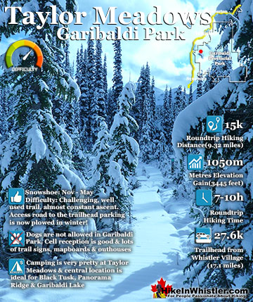
Whistler Snowshoe Trails
![]() Blueberry Trail
Blueberry Trail ![]() Brandywine Falls
Brandywine Falls ![]() Cheakamus River
Cheakamus River ![]() Elfin Lakes
Elfin Lakes ![]() Flank Trail
Flank Trail ![]() Joffre Lakes
Joffre Lakes ![]() Nairn Falls
Nairn Falls ![]() Parkhurst Ghost Town
Parkhurst Ghost Town ![]() Rainbow Falls
Rainbow Falls ![]() Rainbow Lake
Rainbow Lake ![]() Rainbow Park
Rainbow Park ![]() Sproatt East
Sproatt East ![]() Taylor Meadows
Taylor Meadows ![]() Train Wreck
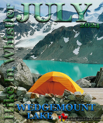
Train Wreck ![]() Wedgemount Lake
Wedgemount Lake
![]() January
January ![]() February
February ![]() March
March ![]() April
April ![]() May
May ![]() June
June ![]() July
July ![]() August
August ![]() September
September ![]() October
October ![]() November
November ![]() December
December
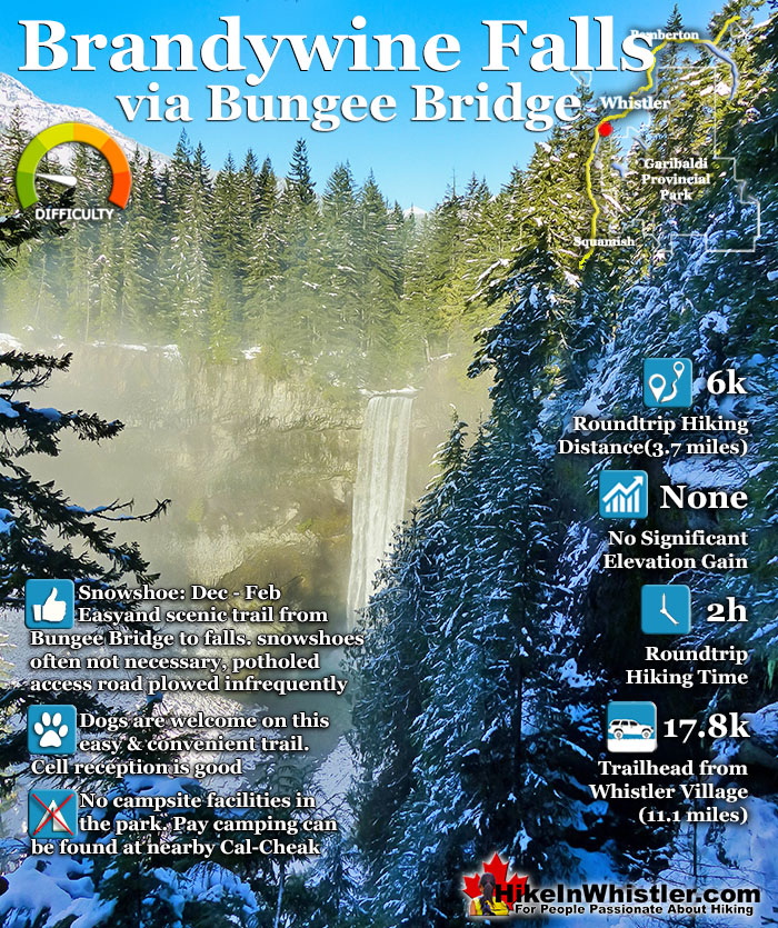
These layers, formed by separate lava flows impacting the glacier that once filled this valley. Another viewing area faces the south, looking down the valley and over Daisy Lake. Brandywine Falls Provincial Park is located along the Sea to Sky Highway, 15 minutes south of Whistler and BC Parks has locked the parking lot during winter for years. In 2021, despite the ever-increasing popularity of the park, has now put up tow away zone signs along the large turnaround area outside the gate. With no decent parking alternatives nearby this has prevented thousands of people from enjoying this beautiful park and one of the best, and free attractions along the Sea to Sky Highway. Some wintertime visitors to Brandywine Falls know to park at the Bungee Bridge down the very potholed Cal-Cheak forest service road. As inconvenient as this sounds, it is actually a pretty nice alternative as the Bungee Bridge is a worthwhile sight on its own and the 3 kilometre trail to Brandywine Falls is nice and easy. There are quite a few highlights along the Bungee Bridge to Brandywine Falls trail. The Bungee Bridge is quite an impressive sight to see spanning Cheakamus River high above the tree tops. Whistler Bungee is open year-round which is why the road is plowed in the winter and drivable. When they have bookings you will see people bungee jumping off the bridge and there is a great viewing area across from the bridge at the edge of the cliffs. Cheakamus River is a beautiful, crashing river cutting through a deep canyon far below and seeing it from such a height is fantastic. The Sea to Sky Trail is another highlight of this hike as it is easy to follow, wide and well defined with signs at every junction.
Bungee Bridge to Brandywine Map
After you cross the Bungee Bridge the Brandywine Falls viewpoint is just 2.7 kilomtres away. The viewpoint hangs over the vertical cliff over the deep chasm that Brandywine Falls drops into. There are nice information boards at the viewpoint explaining some of the interesting geology and history of the area. Further along the trail leads you to another viewpoint and more informative boards depicting the geology of the area. The viewpoint looks over Daisy Lake far below and on a sunny winter day the view is spectacular.

Bungee Bridge to Brandywine Falls Trail Stats:
Driving There: 25 minutes south of Whistler Village(17.8 kilometres/11.1 miles) Hiking Distance: 3 kilometres/1.9 miles, one way from the Bungee Bridge parking to Brandywine Falls. Hiking Time: 1 hour there and 1 hour back. Elevation Change: minimal Fees: None Campsites: No Camping Allowed: No Difficulty: Easy, well defined, wide gravel trail Kid Friendly: Yes, short enough to be fun, not too exhausting Dog Friendly: Yes
Whistler Bungee Bridge to Brandywine Falls
![]() The three kilometre Cal-Cheak forest service road takes you through the Cal-Cheak Campground. The name Cal-Cheak is derived from Callaghan Creek and Cheakamus River which flow on either side of the campground and merge at its southern end. The bridge you drive across on the Cal-Cheak FSR is over Cheakamus River just before it merges with Callaghan Creek. The Sea to Sky Trail which runs through the campground merges, onto and overlaps the Cal-Cheak FSR all the way to the Bungee Bridge.
The three kilometre Cal-Cheak forest service road takes you through the Cal-Cheak Campground. The name Cal-Cheak is derived from Callaghan Creek and Cheakamus River which flow on either side of the campground and merge at its southern end. The bridge you drive across on the Cal-Cheak FSR is over Cheakamus River just before it merges with Callaghan Creek. The Sea to Sky Trail which runs through the campground merges, onto and overlaps the Cal-Cheak FSR all the way to the Bungee Bridge.
Whistler Bungee Bridge Parking

Whistler Bungee Bridge History
![]() The parking area for the Bungee Bridge is located directly under the bridge. The 2 metre wide, 100 metre long, $300,000 bridge was built in 2002 by Whistler Bungee. Spanning the large canyon its highest point is 50 metres above Cheakamus River. Back in 1994 when there were competing bids for commercial tenures for bungee jumping in Whistler, Whistler Bungee Inc won, in large part by building the bridge for public use as well as for their commercial use.
The parking area for the Bungee Bridge is located directly under the bridge. The 2 metre wide, 100 metre long, $300,000 bridge was built in 2002 by Whistler Bungee. Spanning the large canyon its highest point is 50 metres above Cheakamus River. Back in 1994 when there were competing bids for commercial tenures for bungee jumping in Whistler, Whistler Bungee Inc won, in large part by building the bridge for public use as well as for their commercial use.
The Sea to Sky Trail to Whistler Bungee Bridge

The Sea to Sky Trail
![]()
![]() A decade later when plans for the enormous Sea to Sky Trail were in the works, the Bungee Bridge was incorporated into the route. It is also why the Sea to Sky Trail overlaps the Cal-Cheak forest service road here, despite there being a beautiful forest trail running through the campground, across Cal-Cheak Suspension Bridge and onto Brandywine Falls. That route is arguably nicer to hike and bike, but of coarse misses the Bungee Bridge, which is too nice of an attraction to not include along the Sea to Sky Trail.
A decade later when plans for the enormous Sea to Sky Trail were in the works, the Bungee Bridge was incorporated into the route. It is also why the Sea to Sky Trail overlaps the Cal-Cheak forest service road here, despite there being a beautiful forest trail running through the campground, across Cal-Cheak Suspension Bridge and onto Brandywine Falls. That route is arguably nicer to hike and bike, but of coarse misses the Bungee Bridge, which is too nice of an attraction to not include along the Sea to Sky Trail.

Mount Brew from the Bungee Bridge
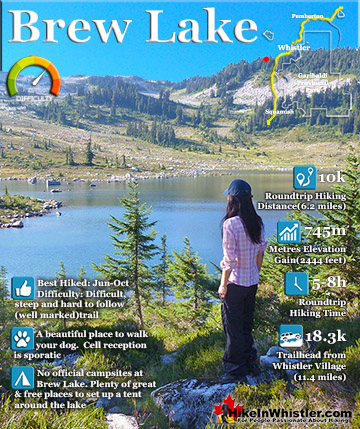
The canyon above Cheakamus River is quite wide and the bridge starts back from the parking lot and you walk almost directly above where your car is parked far below. There is only one pair of enormous girders that support the weight of the bridge near the middle and these are close to the parking area. Looking through the grating below your feet you can see treetops far below and Cheakamus River comes into view very far below. Looking up in the distance you can see Mount Brew's broad snowy form. Brew Lake is a nice hike that used to begin by hiking along the train tracks south of Brandywine Falls and spotting the barely marked trail along the way. In recent years the Brew Lake trailhead is found up a logging road past Whistler RV Park and has the benefit of being shorter and avoids illegally walking along the train tracks.
Snowy Whistler Bungee Bridge

Looking across the gorge you can see an old wooden fence that runs along the vertical cliff. The fence extends along the cliffs to the viewing area for watching people bungee jump. The Sea to Sky Trail continues past the viewing area then bends sharply right and into the forest toward Brandywine Falls.
Whistler Bungee Bridge Wintertime View

Black Tusk from the Bungee Bridge
Partway across the bridge if you look south you will see Black Tusk looking amazingly distinct surrounded by smooth, snow covered hills. On the snow covered hill next to Black Tusk you can see some towers. These are microwave towers and there is actually a road that leads right up to them and from there you are very close to Black Tusk. Unfortunately there is a locked gate near the start of this road preventing access to what would be the best access point to Garibaldi Provincial Park. It would also divert people away from the Rubble Creek trailhead to Black Tusk and Garibaldi Lake. The Rubble Creek trailhead is located in the shadow of The Barrier which partly collapses ever couple centuries and fills the valley below with rubble. It could happen any day, which is why there is no camping near the Rubble Creek trailhead, which at a moments notice could be swept away by a torrent of rock 40 metres deep and moving at over 100 kilometres per hour. Despite pressure from hiking interests to open up the microwave tower road as a new trailhead to Garibaldi Park, BC Parks has instead quadrupled the size of the parking lot at Rubble Creek in recent years to accommodate the demand for the most popular trailhead to the park.
Whistler Bungee Bridge View of Black Tusk

At the high point near the middle of the Bungee Bridge, Whistler Bungee has the jump area. They do jumps on demand and usually the bridge is deserted, especially in the winter months.
Whistler Bungee Bridge is Very Kid Friendly

Whistler Bungee Bridge View of Cheakamus River

When Whistler Bungee is doing jumps the bridge erupts into a hive of activity with spectators, jumpers and employees.

Winter Bungee is Open Year-Round

At the far side of the Bungee Bridge you arrive at the Whistler Bungee desk and viewing room. During busy times of operation this area is manned frequently, however in the winter it is usually empty. Down a short walkway there is a partly enclosed room that is a good shelter in bad weather. There are a few places to sit and you have a partial view of the bridge, though not the best view of the jumpers.
Whistler Bungee Viewpoint Shelter

In the opposite direction the Sea to Sky Trail enters Brandywine Falls Provincial Park. The sign reads 2.7 kilometres to Brandywine Falls and in the opposite direction back across the Bungee Bridge, Whistler Village is 20.3 kilometres.
Entering Brandywine Falls Provincial Park

There is a nice picnic area here next to Pothole Lake which is frozen over during the winter and often has an area cleared for skating.

Pothole Lake Next to Whistler Bungee Bridge

Pothole Lake: Jump Ahead & Lakes of Fire Mural
Brandywine Falls Provincial Park has excellent interpretive murals depicting the interesting geology and creatures that inhabit the area. Northern Red-legged Frogs inhabit the wetlands here and can sometimes be spotted in the summer. The geology explaining the strangely flat, solid rock ground you find yourself walking on and the numerous shallow ponds throughout the forest is the result of a lava flow that solidified here about 13,000 years ago.


The views of the Bungee Bridge get better and better the further you walk along the fenced off cliff high above Cheakamus River. Booking a jump with Whistler Bungee is easy and can be done on their website, by phone: 6049389333, or by email: [email protected].
Winter Bungee Jumping


Sea to Sky Trail to Brandywine Falls
The Sea to Sky Trail between the Bungee Bridge and Brandywine Falls is not overly interesting. It meanders for 2.7 kilometres through the forest and emerges at the Brandywine Falls trail running left and right. In the winter the trail is often deep with snow and snow laden trees bending over the trail.
Sea to Sky Trail Sign at Brandywine Falls

After just 100 metres you arrive at the Brandywine Falls lookout perched on the edge of the cliff directly across from the falls.
Brandywine Falls Viewpoint in Winter

Brandywine Falls in Winter

Wintertime Close Up View of Brandywine Falls


Icicles hanging from the crumbling rock face. You can see the symmetrical shapes in the angular blocks of rock that make up the cliff. This columnar jointing is caused when lava pooled against the glacier that filled this valley over 13000 years ago. When lava rapidly cools against solid ice it fractures in these strangely uniform shapes.


Looking south from the Brandywine Falls lookout you get a great view down the valley with Daisy Lake hidden under the early morning mist. Daisy Lake was originally much smaller, but was dammed several decades ago in order to build the hydroelectric power station that can be seen on the drive up to Whistler off the Sea to Sky Highway.
Brandywine Falls Daisy Lake Viewpoint

Like a Water Grindstone Mural
The interesting mural at the Brandywine Falls lookout explains the lava flows that solidified into layers of fractured basalt. The basalt layers are separated by soft layers of ash. Over time water penetrates the cracks in the basalt and washes away the soft layers of ask. Without the support of the underlying ash layer, the basalt crumbles away. This process has taken thousands of years to carve the canyon visible today.

From the Brandywine Falls lookout you will notice the trail continues further south. A few metres along you come to a metal fence at the edge of the cliff and another great view of the falls, this time framed by snowy trees.

Daisy Lake Viewpoint
A few metres past the second viewpoint you come to the end of the trail and a beautiful view overlooking Daisy Lake. This nice, round area is south facing and very sunny on a clear day. The view is sensational over the deep valley far below.

On a clear day you can see Black Tusk at a slightly different angle than from the Brandywine Falls Daisy Lake viewpoint. The viewing area is fenced off as the drop off is quite sudden. It is possible to hike down to the base of the falls if you hike along the gently sloping ridge to the left until it merges with the boulder field leading down into the valley. It is definitely not easy and potentially quite dangerous, especially in the winter, but manageable by the adventurous and careful.
Summertime View from the Daisy Lake Viewpoint

The Earth Moves Mural at the Daisy Lake Viewpoint
The Earth Moves Under Your Feet mural at the Daisy Lake viewpoint is very interesting. This one depicts the continental drift that causes the ground underneath us to move 4 centimetres per year. The intense heat from earth's core creates currents that move plates around on the surface pushing up mountains and causing volcanoes and earthquakes. Black Tusk was a volcano formed fairly recently and though it once had a fairly conventional volcano shape, its outer layers of rock have crumbled away revealing its distinct, tusk-like core.

Back on the Brandywine Falls trail you cross the active train tracks. In the winter you get a serene view of snow covered tracks disappearing into the distance. Looking north you see the small bridge over Brandywine Creek.
Winter Wonderland Train Tracks View

At the railway bridge over Brandywine Creek you get an interesting view of the creek just before it crashes 70 metres into the abyss far below.
Winter View of the Top of Brandywine Falls

Back on the Brandywine Falls trail you are just a short walk to the large parking area for the park. BC Parks has a big yellow gate preventing access to the parking lot in the winter and since 2021 threatens to tow away cars parked in the big turnaround area outside the gate. This is unfortunate as parking here makes visiting the falls very convenient and easy as the trail is less than a kilometre and very scenic. In the parking lot you have more nice murals depicting more history of the area.
Brandywine Falls Provincial Park Parking Lot in Winter

BC Parks Blocks Winter Access
![]() The nice covered bridge over Brandywine Creek marks the trailhead to Brandywine Falls. Covered bridges are useful in winter for keeping snow off and ensuring they are safe to cross. It doesn't take long in winter for snow to pile up higher than the railings on a bridge and cause a collapse as well as making it sketch to cross, especially near the top of a waterfall. Unfortunately this nice bridge is now not used for half the year as BC Parks actively discourages visitors to this beautiful park and the normal trailhead and parking is now an unnecessary side trail.
The nice covered bridge over Brandywine Creek marks the trailhead to Brandywine Falls. Covered bridges are useful in winter for keeping snow off and ensuring they are safe to cross. It doesn't take long in winter for snow to pile up higher than the railings on a bridge and cause a collapse as well as making it sketch to cross, especially near the top of a waterfall. Unfortunately this nice bridge is now not used for half the year as BC Parks actively discourages visitors to this beautiful park and the normal trailhead and parking is now an unnecessary side trail.
The Start of the Brandywine Falls Trail

Brandywine Falls Trail in Winter


Getting to the Bungee Bridge to Brandywine Falls
![]() As of 2021 the area outside the gated parking lot to Brandywine Falls Provincial Park is a tow away zone during the winter. The only reasonably close parking can be found at the opposite side of the park, 3 kilometres down the Cal-Cheak forest service road at the Whistler Bungee Bridge (aka Cheakamus Bungee Bridge). The 3 kilomtre drive along the very potholed, though otherwise flat logging road that is snowplowed all winter long. The turnoff to Cal-Cheak forest service road is north of the Brandywine Falls parking lot. If driving from Whistler Village, zero your odometer at Village Gate Boulevard and drive south on Highway 99. There is no way to turn left on the highway at Cal-Cheak, so you have to continue past it and do a U-turn at Callaghan. At 13.8 kilometres turn right onto Callaghan Valley Road, do an immediate u-turn and get back on the highway heading north toward Whistler. Keep your eyes out for the signs for Whistler Bungee from now on. At 14.7 kilometres turn right onto Cal-Cheak forest service road and drive down this very potholed, gravel road for 3 kilometres to arrive at the parking area directly under the Whistler Bungee Bridge.
As of 2021 the area outside the gated parking lot to Brandywine Falls Provincial Park is a tow away zone during the winter. The only reasonably close parking can be found at the opposite side of the park, 3 kilometres down the Cal-Cheak forest service road at the Whistler Bungee Bridge (aka Cheakamus Bungee Bridge). The 3 kilomtre drive along the very potholed, though otherwise flat logging road that is snowplowed all winter long. The turnoff to Cal-Cheak forest service road is north of the Brandywine Falls parking lot. If driving from Whistler Village, zero your odometer at Village Gate Boulevard and drive south on Highway 99. There is no way to turn left on the highway at Cal-Cheak, so you have to continue past it and do a U-turn at Callaghan. At 13.8 kilometres turn right onto Callaghan Valley Road, do an immediate u-turn and get back on the highway heading north toward Whistler. Keep your eyes out for the signs for Whistler Bungee from now on. At 14.7 kilometres turn right onto Cal-Cheak forest service road and drive down this very potholed, gravel road for 3 kilometres to arrive at the parking area directly under the Whistler Bungee Bridge.

The Sea to Sky Trail runs through Whistler and overlaps the Cal-Cheak forest service road. Passing by the Cal-Cheak Campground you will have driven past the Sea to Sky Trail where it emerges from the forest and continues along the road you drove in along.

More Whistler Snowshoe Trails
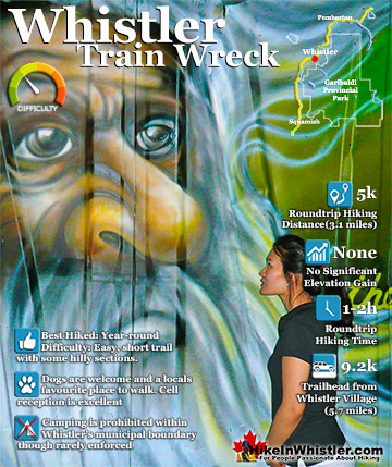
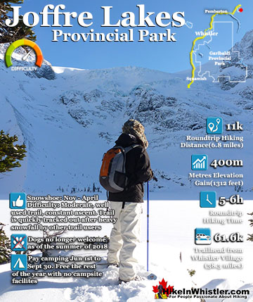
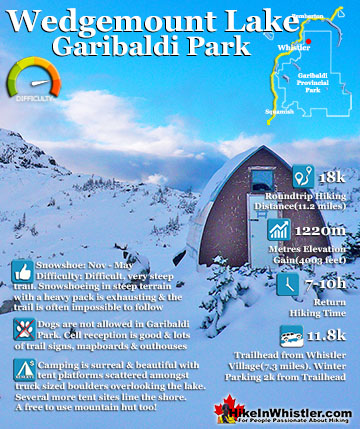
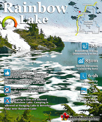
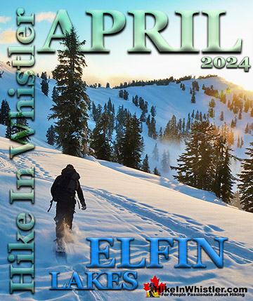
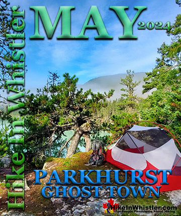
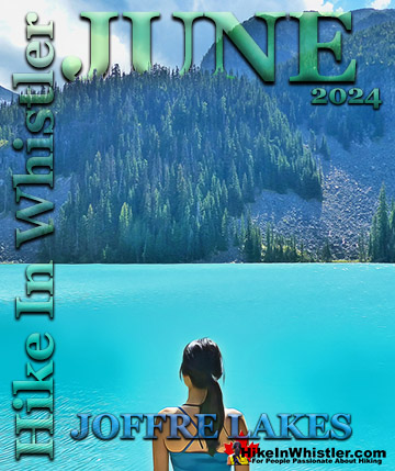
![]() There are plenty of beautiful and free snowshoe trails in Whistler and Garibaldi Provincial Park. From the surreal paintings of Whistler Train Wreck to the magnificent mountain serenity of Wedgemount Lake in Garibaldi Park. Trails range from extremely easy, like the short, flat trails to Brandywine Falls and Rainbow Park. To challenging and long trails to places like Elfin Lakes, Taylor Meadows and Wedgemount Lake. Whistler even has a growing network of snowshoe trails to Parkhurst Ghost Town on the far side of Green Lake. There are a couple pay-use snowshoeing areas in Whistler, however most free trails are as good or better. Whistler Train Wreck is an easy/moderate snowshoe trail that takes you through a deep forest, over Cheakamus River via a very pretty suspension bridge, and to a series of decades old, wrecked train cars. Elfin Lakes in Garibaldi Provincial Park is another beautiful place to snowshoe. Located at the south end of Garibaldi Park, the Elfin Lakes trailhead is found in Squamish. The trail is not overly difficult, however it is quite long. A consistently uphill, 11 kilometre(13.7 mile) trail through some spectacular scenery takes you to the marvelous Elfin Lakes hut. For easier snowshoeing, Rainbow Falls is a good option. Located just a short drive from Whistler Village, the Rainbow Trail is a beautiful trek through the forest in a winter wonderland to a hidden waterfall surrounded by deep pillows of powdery snow. For more challenging snowshoeing, Joffre Lakes Provincial Park is hard to beat. A long, though beautiful drive into the mountains, north of Pemberton takes you to this moderately challenging, 11 kilometre(6.8mile) roundtrip snowshoe trail. The frequently steep, winding trail takes you through a winter paradise and around, or over three frozen lakes. Back in Whistler, an excellent place to snowshoe is to Parkhurst Ghost Town. Sitting on the far side of Green Lake, Parkhurst was a thriving logging community several decades ago. It has since been abandoned except for intermittent squatter communities over the years.
There are plenty of beautiful and free snowshoe trails in Whistler and Garibaldi Provincial Park. From the surreal paintings of Whistler Train Wreck to the magnificent mountain serenity of Wedgemount Lake in Garibaldi Park. Trails range from extremely easy, like the short, flat trails to Brandywine Falls and Rainbow Park. To challenging and long trails to places like Elfin Lakes, Taylor Meadows and Wedgemount Lake. Whistler even has a growing network of snowshoe trails to Parkhurst Ghost Town on the far side of Green Lake. There are a couple pay-use snowshoeing areas in Whistler, however most free trails are as good or better. Whistler Train Wreck is an easy/moderate snowshoe trail that takes you through a deep forest, over Cheakamus River via a very pretty suspension bridge, and to a series of decades old, wrecked train cars. Elfin Lakes in Garibaldi Provincial Park is another beautiful place to snowshoe. Located at the south end of Garibaldi Park, the Elfin Lakes trailhead is found in Squamish. The trail is not overly difficult, however it is quite long. A consistently uphill, 11 kilometre(13.7 mile) trail through some spectacular scenery takes you to the marvelous Elfin Lakes hut. For easier snowshoeing, Rainbow Falls is a good option. Located just a short drive from Whistler Village, the Rainbow Trail is a beautiful trek through the forest in a winter wonderland to a hidden waterfall surrounded by deep pillows of powdery snow. For more challenging snowshoeing, Joffre Lakes Provincial Park is hard to beat. A long, though beautiful drive into the mountains, north of Pemberton takes you to this moderately challenging, 11 kilometre(6.8mile) roundtrip snowshoe trail. The frequently steep, winding trail takes you through a winter paradise and around, or over three frozen lakes. Back in Whistler, an excellent place to snowshoe is to Parkhurst Ghost Town. Sitting on the far side of Green Lake, Parkhurst was a thriving logging community several decades ago. It has since been abandoned except for intermittent squatter communities over the years.

More Whistler & Garibaldi Park Snowshoe Trails!
Where to Hike in Whistler & Garibaldi Park by Month

Amazing Whistler & Garibaldi Park Hiking Trails!