
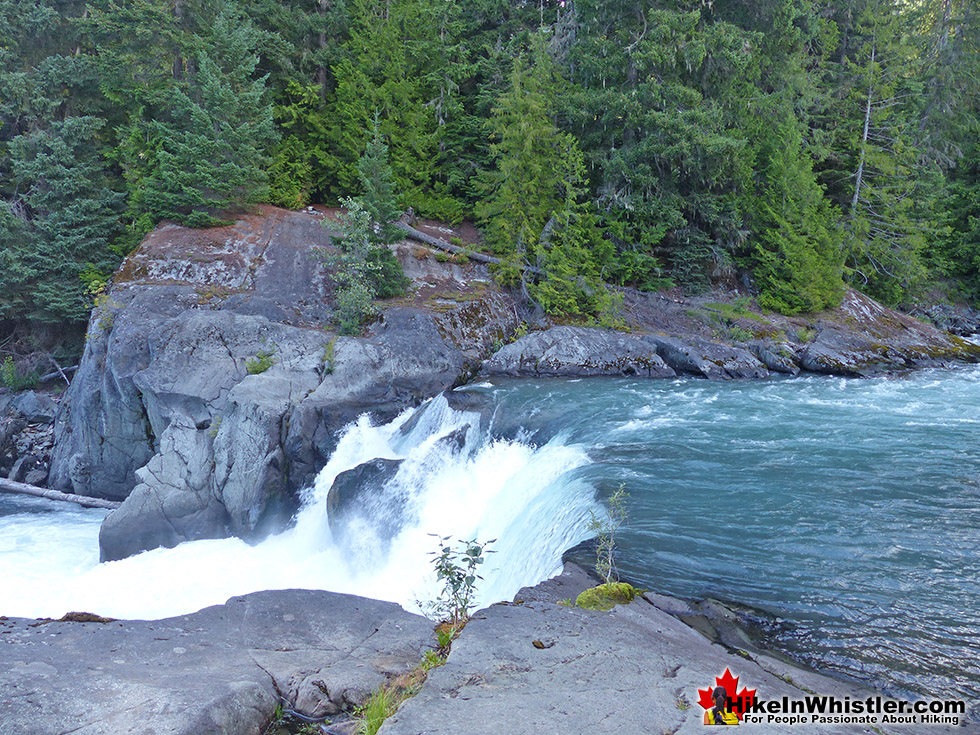
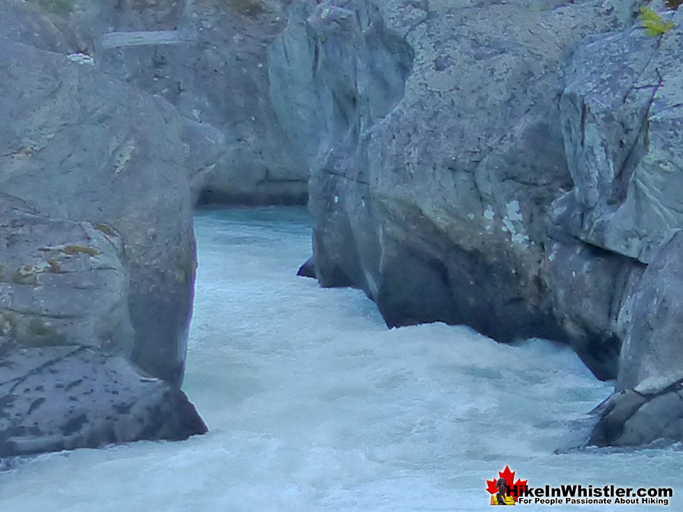
![]() Cheakamus River is a beautiful, crashing, turquoise coloured river that flows from Cheakamus Lake, through Whistler Interpretive Forest, then down past Brandywine Falls to Daisy Lake, then all the way to Squamish where it merges with Squamish River and into the ocean. Cheakamus River has quite an extensive network of hiking and biking trails that run alongside it. The Riverside trail and the Farside trail run on either side of Cheakamus River and connect at both ends by bridges.
Cheakamus River is a beautiful, crashing, turquoise coloured river that flows from Cheakamus Lake, through Whistler Interpretive Forest, then down past Brandywine Falls to Daisy Lake, then all the way to Squamish where it merges with Squamish River and into the ocean. Cheakamus River has quite an extensive network of hiking and biking trails that run alongside it. The Riverside trail and the Farside trail run on either side of Cheakamus River and connect at both ends by bridges.
 Very easily accessible, park at various places
- Bus stop near the trails
- Connect to Logger's Lake & Whistler Train Wreck
- Ideal trail running route & dog friendly
- An easy & family friendly trail
- Many great spots for a picnic
- Usually quiet & has little elevation change!
 Trails are not overly exciting
- Not as impressive as other Whistler trails
- No camping allowed in the area
Whistler & Garibaldi Hiking
![]() Alexander Falls
Alexander Falls ![]() Ancient Cedars
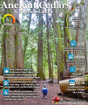
Ancient Cedars ![]() Black Tusk
Black Tusk ![]() Blackcomb Mountain
Blackcomb Mountain ![]() Brandywine Falls
Brandywine Falls ![]() Brandywine Meadows
Brandywine Meadows ![]() Brew Lake
Brew Lake ![]() Callaghan Lake
Callaghan Lake ![]() Cheakamus Lake
Cheakamus Lake ![]() Cheakamus River
Cheakamus River ![]() Cirque Lake
Cirque Lake ![]() Flank Trail
Flank Trail ![]() Garibaldi Lake
Garibaldi Lake ![]() Garibaldi Park
Garibaldi Park ![]() Helm Creek
Helm Creek ![]() Jane Lakes
Jane Lakes ![]() Joffre Lakes
Joffre Lakes ![]() Keyhole Hot Springs
Keyhole Hot Springs ![]() Logger’s Lake
Logger’s Lake ![]() Madeley Lake
Madeley Lake ![]() Meager Hot Springs
Meager Hot Springs ![]() Nairn Falls
Nairn Falls ![]() Newt Lake
Newt Lake ![]() Panorama Ridge
Panorama Ridge ![]() Parkhurst Ghost Town
Parkhurst Ghost Town ![]() Rainbow Falls
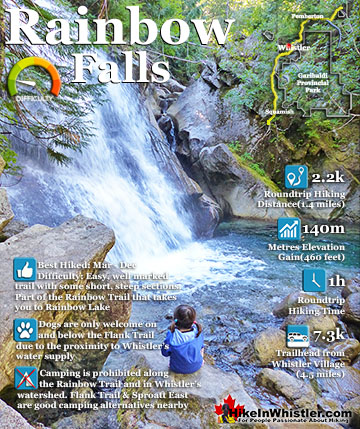
Rainbow Falls ![]() Rainbow Lake
Rainbow Lake ![]() Ring Lake
Ring Lake ![]() Russet Lake
Russet Lake ![]() Sea to Sky Trail
Sea to Sky Trail ![]() Skookumchuck Hot Springs
Skookumchuck Hot Springs ![]() Sloquet Hot Springs
Sloquet Hot Springs ![]() Sproatt East
Sproatt East ![]() Sproatt West
Sproatt West ![]() Taylor Meadows
Taylor Meadows ![]() Train Wreck
Train Wreck ![]() Wedgemount Lake
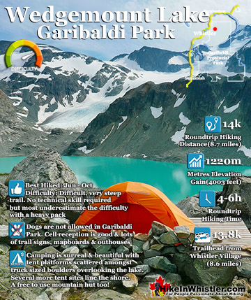
Wedgemount Lake ![]() Whistler Mountain
Whistler Mountain
![]() January
January ![]() February
February ![]() March
March ![]() April
April ![]() May
May ![]() June
June ![]() July
July ![]() August
August ![]() September
September ![]() October
October ![]() November
November ![]() December
December
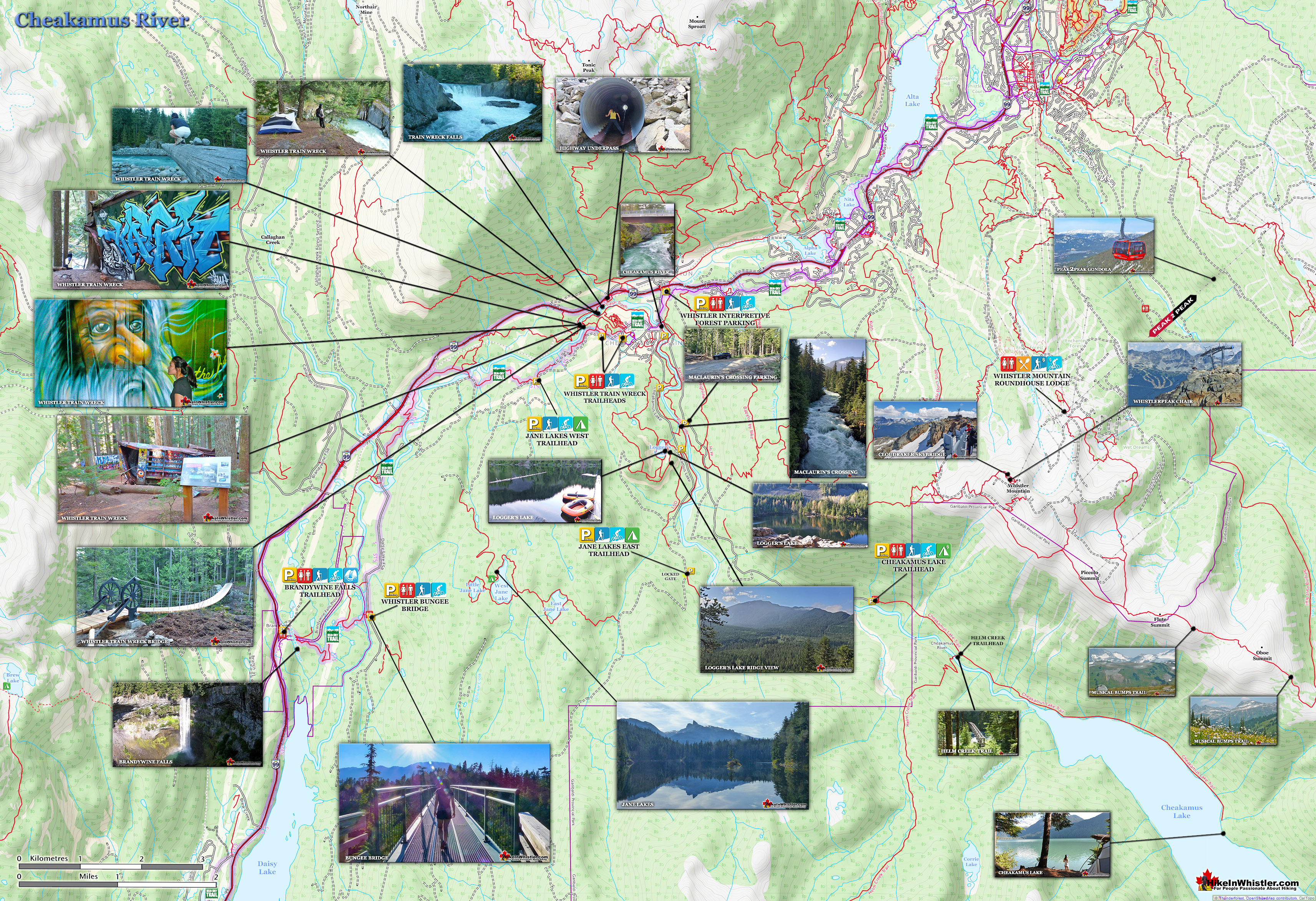
Connecting to the Riverside trail is the short trail to Logger's Lake, which in turn is surrounded by more hiking and biking trails. The Lake Loop trail, Crater Rim trail, the Ridge trail, Upper Ridge trail, and the Lower Ridge trail. On the Farside trail along Cheakamus River you can connect to Cheakamus Road(gravel road) and hike 6 kilometres up to the Cheakamus Lake trailhead. On the other side of the neighbourhood of Cheakamus Crossing, which Cheakamus River bends around keeping the Sea to Sky Highway and train tracks on its opposite side, you find still more hiking and biking trails. Trash trail hugs the river all the way to the beautiful bridge to Whistler Train Wreck. Or, continue past the bridge to connect with the Sea to Sky trail. For the most part, however, if you are talking about the Cheakamus River trails you are likely talking about the Farside and Riverside trails in Whistler's Interpretive Forest. Eight kilometres south of Whistler Village and surrounding the recently constructed neighbourhood of Cheakamus Crossing is Whistler Interpretive Forest. This beautiful forest surrounds the Cheakamus River and has been cut and replanted in several areas in the past decades. Hiking and biking trails have sprung up over the years making the area a wonderful place to explore.

No Camping Allowed
Unfortunately, the Interpretive Forest is day-use only, no camping is permitted. The main highlights of the Interpretive Forest are the Cheakamus River trails, and the extraordinary Logger's Lake. Logger's Lake, just a short hike from the Cheakamus River suspension bridge, sits within a 10000 year old, extinct volcano and is a hiking destination on its own. Logger's Lake is a beautifully hidden paradise for swimming, fishing, sightseeing and relaxing.


Parking Areas Along Cheakamus River
Parking can be found at several places along both sides of Cheakamus River. If driving from Whistler Village, if you turn left at Cheakamus Lake Road, drive 300 metres, then turn left on to the gravel road, you will immediately see an area to park. This is one end of the Farside and Riverside trails(see the map below). Located next to the vehicle/pedestrian bridge over the river, this is where the Farside and Riverside trails meet. They also meet two kilometres upriver at the suspension bridge. At the suspension bridge you will find parking areas on either side of the river. One of the parking areas is also the parking area for Logger's Lake, making it a beautiful starting point to hike both Logger's Lake and Cheakamus River in just a couple hours. There are several more excellent places to park to begin hiking or biking around the Cheakamus River. You can park at various places within sight of the river on either side of it just steps from a hiking trail. The Whistler Interpretive Forest trailhead parking just off the Sea to Sky Highway is large, easy to find and adjacent to the Sea to Sky trail. This is an ideal place to park if you are biking the trails. If you are hiking, however, you might want to drive a couple hundred metres past and then turn left onto Cheakamus Lake Road. This gravel road almost immediately forks. Continuing straight takes you along the left side of Cheakamus River and taking the right fork follows the opposite side. There are excellent road and trail signs at this junction and the ones further along.


Cheakamus River Trail Map
![]() The Cheakamus River trails centre around two core trails that link via the MacLaurin's Crossing bridge at one end and the Cheakamus Crossing bridge at the other. These two trails, Riverside & Farside, lay at the heart of Whistler Interpretive Forest, which encompasses the surrounding areas of beyond Cheakamus River. These areas consist of the Riverside trail, Farside trail, Discovery Loop, Ridge trail, Riparian Interpretive trail, Crater Rim trail, Craterview Loop, Plantation Loop, Biogeoclimatic Loop, Crater Lookout and more. The Riverside trail is an easy to moderate, 2 kilometre multi-use trail with a a few steep switchbacks and a couple very scenic viewpoints over the river. At MacLaurin's Crossing it connects to the Farside trail that hugs the opposite side of the river and brings you back to where you started in Cheakamus Crossing.
The Cheakamus River trails centre around two core trails that link via the MacLaurin's Crossing bridge at one end and the Cheakamus Crossing bridge at the other. These two trails, Riverside & Farside, lay at the heart of Whistler Interpretive Forest, which encompasses the surrounding areas of beyond Cheakamus River. These areas consist of the Riverside trail, Farside trail, Discovery Loop, Ridge trail, Riparian Interpretive trail, Crater Rim trail, Craterview Loop, Plantation Loop, Biogeoclimatic Loop, Crater Lookout and more. The Riverside trail is an easy to moderate, 2 kilometre multi-use trail with a a few steep switchbacks and a couple very scenic viewpoints over the river. At MacLaurin's Crossing it connects to the Farside trail that hugs the opposite side of the river and brings you back to where you started in Cheakamus Crossing.

The Cheakamus River Hiking Trails
![]() If you are after a very scenic 4 kilometre(1 hour) hike through the beautiful forest along the river to MacLaurin's Crossing, then back along the other side of the river, parking near this junction is possibly the best place to do it. You can simply park at the edge of the gravel road near one of many trails you will see at this junction or better yet, take the right fork, cross the vehicle bridge and park at the large parking area you will immediately see. You can drive further along this gravel road and find another parking area just steps from the Riverside trail and within earshot of the crashing Cheakamus River. Another kilometre past this parking area and you will see yet another large parking area on your left. This parking area is generally used for people hiking the short trail up to Logger's Lake, however it is also a great place to park for Cheakamus River as it is just a 5 minute hike along the river to MacLaurin's Crossing.
If you are after a very scenic 4 kilometre(1 hour) hike through the beautiful forest along the river to MacLaurin's Crossing, then back along the other side of the river, parking near this junction is possibly the best place to do it. You can simply park at the edge of the gravel road near one of many trails you will see at this junction or better yet, take the right fork, cross the vehicle bridge and park at the large parking area you will immediately see. You can drive further along this gravel road and find another parking area just steps from the Riverside trail and within earshot of the crashing Cheakamus River. Another kilometre past this parking area and you will see yet another large parking area on your left. This parking area is generally used for people hiking the short trail up to Logger's Lake, however it is also a great place to park for Cheakamus River as it is just a 5 minute hike along the river to MacLaurin's Crossing.

Camping Options Near Cheakamus River
![]() The Whistler Interpretive Forest is sadly for day use only, so no camping is allowed. If it was permitted, there would be plenty of places ideal to put up a tent, including the ridge above Logger's Lake and numerous places along the Cheakamus River. There is of course, excellent pay use campsites at Cheakamus Lake. Helm Creek is another campground that branches off from the Cheakamus Lake trail at 1.5 kilometres. Camping is actually quite good not far from the Cheakamus River trails. Just south, on the Sea to Sky Highway, you will see a sign on your left for Whistler Bungee and Cal-Cheak campground, and just another 5 minutes down the highway you will see on your right a big sign for Whistler RV Park & Campground. This relatively new campground is quite nice, located up on a ridge overlooking snowy mountain peaks including Whistler Mountain and Blackcomb Mountain. Check out free places to camp in Whistler here.
The Whistler Interpretive Forest is sadly for day use only, so no camping is allowed. If it was permitted, there would be plenty of places ideal to put up a tent, including the ridge above Logger's Lake and numerous places along the Cheakamus River. There is of course, excellent pay use campsites at Cheakamus Lake. Helm Creek is another campground that branches off from the Cheakamus Lake trail at 1.5 kilometres. Camping is actually quite good not far from the Cheakamus River trails. Just south, on the Sea to Sky Highway, you will see a sign on your left for Whistler Bungee and Cal-Cheak campground, and just another 5 minutes down the highway you will see on your right a big sign for Whistler RV Park & Campground. This relatively new campground is quite nice, located up on a ridge overlooking snowy mountain peaks including Whistler Mountain and Blackcomb Mountain. Check out free places to camp in Whistler here.
A possible drawback to this campground is that it is far south of Whistler Village, but if you have a vehicle that shouldn't bother you too much. If you would rather a more wilderness style camping, with few to no RV's then the Cal-Cheak Recreation Site is an excellent choice. After turning off the highway at the sign for Whistler Bungee and Cal-Cheak, you will almost immediately see the campsite on your right, and further along on your left. This campsite is beautiful, wild and in between two dramatically beautiful rivers, Cheakamus and Callaghan. All the campsites are drive-in and just steps from a gorgeous river view.
Aerial View of the Cal-Cheak Bridge

Facilities at Cheakamus River
![]() The Cheakamus River trails and the Interpretive Forest don't have any facilities such as outhouses or picnic tables. This is quite nice as to maintain a wild and untouched feeling of the area. Cheakamus Crossing has a few eateries with washrooms. The HI Whistler Hostel has a very nice little coffee shop with a few things to eat and drink. It is worth checking out, not least for a glimpse at Athletes Village. The name given to this neighbourhood for the 2010 Olympics as it accommodated hundreds of athletes. The HI Whistler Hostel is a huge hostel and looks inside and out like a hotel. Very modern and trendy feeling as you walk in the front door. The only drawback to this hostel is its location, as it is 8 kilometres south of Whistler Village, though on a regular bus route.
The Cheakamus River trails and the Interpretive Forest don't have any facilities such as outhouses or picnic tables. This is quite nice as to maintain a wild and untouched feeling of the area. Cheakamus Crossing has a few eateries with washrooms. The HI Whistler Hostel has a very nice little coffee shop with a few things to eat and drink. It is worth checking out, not least for a glimpse at Athletes Village. The name given to this neighbourhood for the 2010 Olympics as it accommodated hundreds of athletes. The HI Whistler Hostel is a huge hostel and looks inside and out like a hotel. Very modern and trendy feeling as you walk in the front door. The only drawback to this hostel is its location, as it is 8 kilometres south of Whistler Village, though on a regular bus route.
Restrictions and Concerns at Cheakamus River
![]()
![]()
![]() No fires are allowed in Whistler's Interpretive Forest as the danger of forest fires is very high. No motorised vehicles on the trails either. Camping is not allowed, however the Interpretive Forest covers quite a large area of wilderness with dozens of idyllic places to sneak a nights sleep in the wilderness. For legal campsite options you have to look further up the Cheakamus Valley. Cheakamus Lake has two very nice, wilderness campsites(pay to use). Helm Creek campground is further up towards Black Tusk. These are both in Garibaldi Provincial Park, which is campsite friendly, but not dog or bike friendly. As mentioned above, the Cal-Cheak Campground and Whistler RV Park & Campground are good options for pay camping.
No fires are allowed in Whistler's Interpretive Forest as the danger of forest fires is very high. No motorised vehicles on the trails either. Camping is not allowed, however the Interpretive Forest covers quite a large area of wilderness with dozens of idyllic places to sneak a nights sleep in the wilderness. For legal campsite options you have to look further up the Cheakamus Valley. Cheakamus Lake has two very nice, wilderness campsites(pay to use). Helm Creek campground is further up towards Black Tusk. These are both in Garibaldi Provincial Park, which is campsite friendly, but not dog or bike friendly. As mentioned above, the Cal-Cheak Campground and Whistler RV Park & Campground are good options for pay camping.
Wildlife at Cheakamus River
![]() The chances of spotting a bear along Cheakamus River or anywhere in the Interpretive Forest are good. If you drive, hike or bike up the 8 kilometre logging road to the Cheakamus Lake trailhead, you will pass numerous piles of bear dung. Often on this road you will encounter bears as well as on the trails. The encounters on the hiking/biking trails can be quite unnerving due to the windy trails causing you to encounter them at close range. There is no great danger for bears in Whistler unless you provoke them. Of course provoking a bear is as easy as having lots of food around and luring one toward you.
The chances of spotting a bear along Cheakamus River or anywhere in the Interpretive Forest are good. If you drive, hike or bike up the 8 kilometre logging road to the Cheakamus Lake trailhead, you will pass numerous piles of bear dung. Often on this road you will encounter bears as well as on the trails. The encounters on the hiking/biking trails can be quite unnerving due to the windy trails causing you to encounter them at close range. There is no great danger for bears in Whistler unless you provoke them. Of course provoking a bear is as easy as having lots of food around and luring one toward you.
Parking & Trailhead Directions to Cheakamus River
![]()
![]()
![]() Parking for the Cheakamus River trails and Whistler's Interpretive Forest are numerous. The main Whistler Interpretive Forest parking lot is located just off the Sea to Sky Highway and easy to spot. There is a bus stop very close to the parking lot, so it is convenient by bus as well. Biking to the Cheakamus River trails is very easy because the Sea to Sky trail and Whistler's Valley Trail system connects to Cheakamus Crossing from the Village. The route is very scenic and on a wide, two lane purpose build, multi-use trail. This trail actually cuts through the Interpretive Forest's parking lot. Other parking areas for Cheakamus River are mostly unmarked, but excellent and convenient. You can in fact park just steps from MacLaurin's Crossing over the river at the parking area, best for the short trek up to Logger's Lake.
Parking for the Cheakamus River trails and Whistler's Interpretive Forest are numerous. The main Whistler Interpretive Forest parking lot is located just off the Sea to Sky Highway and easy to spot. There is a bus stop very close to the parking lot, so it is convenient by bus as well. Biking to the Cheakamus River trails is very easy because the Sea to Sky trail and Whistler's Valley Trail system connects to Cheakamus Crossing from the Village. The route is very scenic and on a wide, two lane purpose build, multi-use trail. This trail actually cuts through the Interpretive Forest's parking lot. Other parking areas for Cheakamus River are mostly unmarked, but excellent and convenient. You can in fact park just steps from MacLaurin's Crossing over the river at the parking area, best for the short trek up to Logger's Lake.

More Great Hiking Around Cheakamus River
![]() Logger's Lake is an amazing little lake hidden up in the deep forest above Cheakamus River. The lake, almost unbelievably exists in a long extinct volcano. However, as soon as you see the lake up close, you quickly come to believe it. The lake sits in an almost cartoonish looking, volcano-shaped bowl, with one side of the bowl a crumbling array of truck sized boulders leading down to the lake. The crater that Logger's Lake sits in was a volcano that pushed through the glacial ice in this valley about 10000 years ago. As the lava cooled it formed the wonderful basalt ridge that is crumbling into valley. As Logger's Lake sits deep in this ancient volcano's vent, it is sheltered from the wind and soaks up the suns rays into the dark boulders all around. As a result makes it the warmest lake for swimming in Whistler.
Logger's Lake is an amazing little lake hidden up in the deep forest above Cheakamus River. The lake, almost unbelievably exists in a long extinct volcano. However, as soon as you see the lake up close, you quickly come to believe it. The lake sits in an almost cartoonish looking, volcano-shaped bowl, with one side of the bowl a crumbling array of truck sized boulders leading down to the lake. The crater that Logger's Lake sits in was a volcano that pushed through the glacial ice in this valley about 10000 years ago. As the lava cooled it formed the wonderful basalt ridge that is crumbling into valley. As Logger's Lake sits deep in this ancient volcano's vent, it is sheltered from the wind and soaks up the suns rays into the dark boulders all around. As a result makes it the warmest lake for swimming in Whistler.

Decades ago a train derailed south of Whistler and seven train cars were left in the forest next to Cheakamus River. As it turns out, time and local effort has transformed this mess into a wonderful work of art, an extraordinary bike park, and a great place to hike. The Whistler Train Wreck. The whole length of the Whistler Train Wreck and Cheakamus River hike is 3 kilometres(each way) and the trails go along the beautiful river as well as several, widely spaced train wrecks.

Cheakamus Lake is another beautiful hiking trail near the Cheakamus River trails. The Cheakamus Lake trailhead is found up an 8 kilometre, very potholed logging road. The hiking trail is pretty easy as you have driven most of the elevation gain to get to the trailhead. From the trailhead you hike along Cheakamus River through a beautiful, old forest, reaching the lake in just 3 kilometres. A fairly easy hiking trail that gains very little elevation.

Whistler's Best Hiking Trails!
Whistler & Garibaldi Park Best Hiking by Month!


Explore BC Hiking Destinations!

Whistler Hiking Trails

Squamish Hiking Trails

Vancouver Hiking Trails

Clayoquot Hiking Trails
Victoria Hiking Trails

