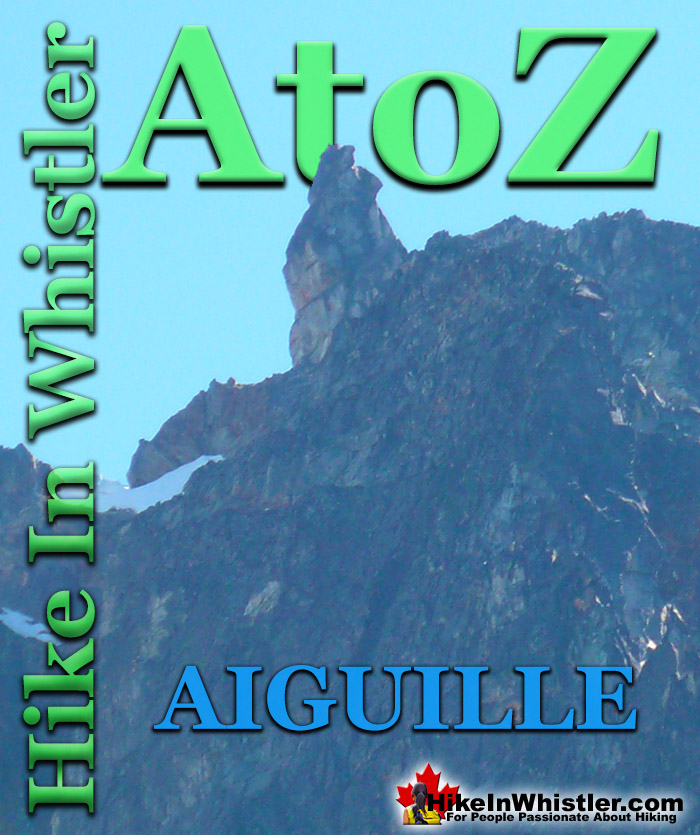
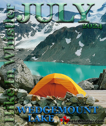
![]() Aiguille: a tall, narrow, characteristically distinct spire of rock. From the French word for "needle". Used extensively as part of the names for many peaks in the French Alps. Around Whistler and in Garibaldi Park you will find several distinct aiguilles. Shown here is the prominent aiguille that stands like a tower at the summit of Rethel Mountain above Wedgemount Lake. Standing near the hut at Wedgemount Lake, Rethel is the towering mountain directly across the lake.
Aiguille: a tall, narrow, characteristically distinct spire of rock. From the French word for "needle". Used extensively as part of the names for many peaks in the French Alps. Around Whistler and in Garibaldi Park you will find several distinct aiguilles. Shown here is the prominent aiguille that stands like a tower at the summit of Rethel Mountain above Wedgemount Lake. Standing near the hut at Wedgemount Lake, Rethel is the towering mountain directly across the lake.
Whistler & Garibaldi Hiking
![]() Alexander Falls
Alexander Falls ![]() Ancient Cedars
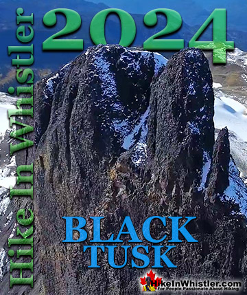
Ancient Cedars ![]() Black Tusk
Black Tusk ![]() Blackcomb Mountain
Blackcomb Mountain ![]() Brandywine Falls
Brandywine Falls ![]() Brandywine Meadows
Brandywine Meadows ![]() Brew Lake
Brew Lake ![]() Callaghan Lake
Callaghan Lake ![]() Cheakamus Lake
Cheakamus Lake ![]() Cheakamus River
Cheakamus River ![]() Cirque Lake
Cirque Lake ![]() Flank Trail
Flank Trail ![]() Garibaldi Lake
Garibaldi Lake ![]() Garibaldi Park
Garibaldi Park ![]() Helm Creek
Helm Creek ![]() Jane Lakes
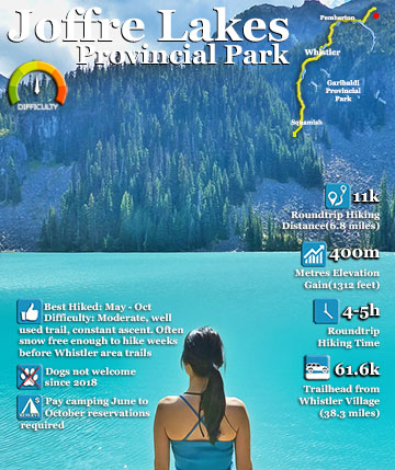
Jane Lakes ![]() Joffre Lakes
Joffre Lakes ![]() Keyhole Hot Springs
Keyhole Hot Springs ![]() Logger’s Lake
Logger’s Lake ![]() Madeley Lake
Madeley Lake ![]() Meager Hot Springs
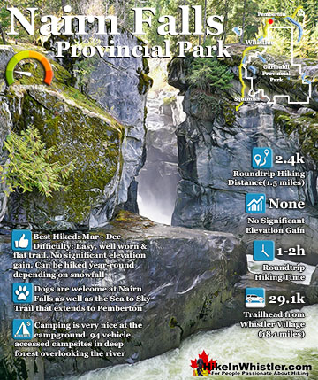
Meager Hot Springs ![]() Nairn Falls
Nairn Falls ![]() Newt Lake
Newt Lake ![]() Panorama Ridge
Panorama Ridge ![]() Parkhurst Ghost Town
Parkhurst Ghost Town ![]() Rainbow Falls
Rainbow Falls ![]() Rainbow Lake
Rainbow Lake ![]() Ring Lake
Ring Lake ![]() Russet Lake
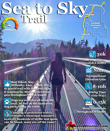
Russet Lake ![]() Sea to Sky Trail
Sea to Sky Trail ![]() Skookumchuck Hot Springs
Skookumchuck Hot Springs ![]() Sloquet Hot Springs
Sloquet Hot Springs ![]() Sproatt East
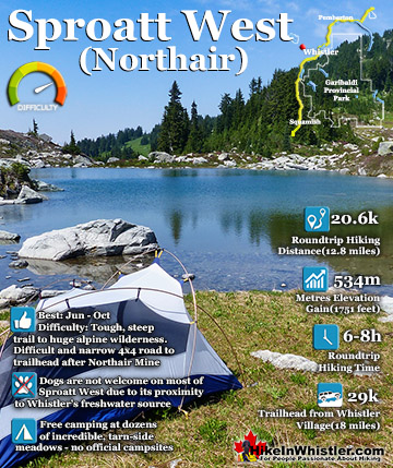
Sproatt East ![]() Sproatt West
Sproatt West ![]() Taylor Meadows
Taylor Meadows ![]() Train Wreck
Train Wreck ![]() Wedgemount Lake
Wedgemount Lake ![]() Whistler Mountain
Whistler Mountain
![]() January
January ![]() February
February ![]() March
March ![]() April
April ![]() May
May ![]() June
June ![]() July
July ![]() August
August ![]() September
September ![]() October
October ![]() November
November ![]() December
December
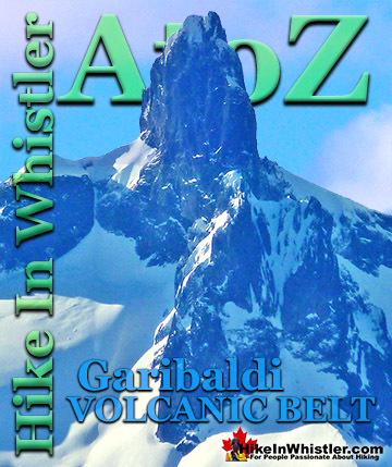
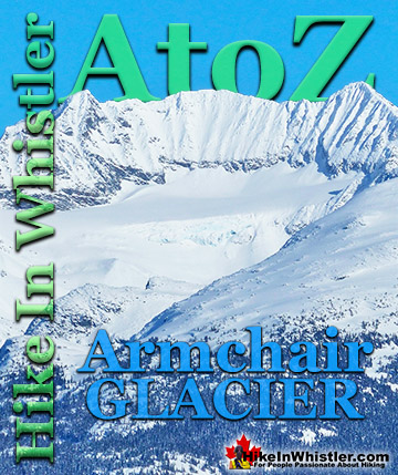
If you are looking at Wedge Mountain from Whistler Village, Rethel Mountain is the second mountain to the left of Wedge. In order they are Wedge Mountain, Parkhurst Mountain and Rethel Mountain. Parkhurst Mountain stretches down the valley to Parkhurst Ghost Town at the shore of Green Lake. Across Wedgemount Lake and still visible from Whistler are Mount Weart, Armchair Glacier and Cook Mountain. If you are new to Whistler and are unfamiliar with Wedge Mountain, it is the strikingly wedge-shaped mountain that dominates the skyline from many places in Whistler. The highest mountain in Garibaldi Provincial Park and easily spotted next to Blackcomb Mountain, which in turn is next to Whistler Mountain. Shown here is Wedge Mountain and Blackcomb Mountain as seen from Rainbow Lake across the valley. The first glimpse of Wedge Mountain, for most, is from the highway as they drive into Whistler. At Function Junction 8 kilometres south of Whistler Village you catch your first beautiful view of this towering mountain. The Sea to Sky Highway lines up with Wedge Mountain a few times as you drive through Whistler and north of Whistler Village you see it almost constantly on your right as you pass Green Lake and continue north toward Pemberton.

Rethel Mountain Aiguille from Wedgemount Lake
From the shore of Wedgemount Lake the aiguille on Rethel Mountain is easily visible and quite distinct. Rethel Mountain and its neighbour to the left, Parkhurst are strikingly beautiful mountains to see and even hear. While camping at the shore of Wedgemount Lake, you will be startled occasionally to hear quite large boulders tumbling down these mountains and into the lake. It happens fairly regularly and you never quite get used to the unnerving sound of falling rocks. It tends to add to the interesting and hostile beauty of this wonderful place.


Wedgemount Lake Maps
Below is a map showing Wedgemount Lake from several vantage points. The upper tent pad view looking across to Wedgemount Glacier, an iceberg in July, the beautiful glacier window, the amazing view from the lower tent pads along Wedgemount Lake. The map also shows the various routes up Wedgemount Glacier to Wedge Mountain. These routes are potentially very dangerous and glacier travel is always unpredictable and hazardous, so make sure you know what you are doing before venturing beyond the glacier window.


Levette Lake View of a Tantalus Range Aiguille
Another good place to see an aiguille is at Levette Lake, south of Whistler, near Squamish. Looking across the lake you get a great view of the Tantalus Range and this marvellous aiguille shown here. Levette Lake is a hidden little lake found just a short drive up Squamish Valley Road. Details, maps and directions can be found at HikeInSquamish.com.


More Whistler & Garibaldi Park Hiking A to Z!


The Best Whistler & Garibaldi Park Hiking Trails!
Whistler & Garibaldi Park Best Hiking by Month!

Explore BC Hiking Destinations!
Whistler Hiking Trails
Squamish Hiking Trails
Vancouver Hiking Trails

Clayoquot Hiking Trails
Victoria Hiking Trails
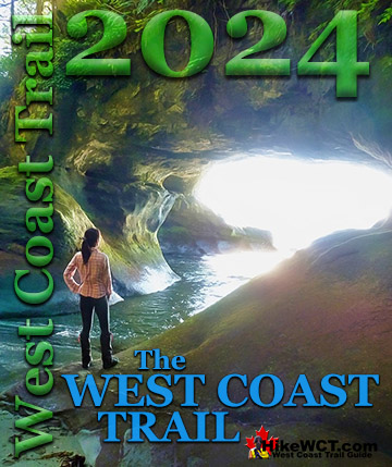
The West Coast Trail
