![]() Wedgemount Lake itself is a magnificent destination for a day hike or spectacular overnight beneath the dazzling mountain peaks and stars. Many sleep under the stars on one of the many beautiful tent platforms that dot the landscape. Solidly built, wooden tent platforms are everywhere you look at Wedgemount Lake. Strategically positioned, these platforms manage to maintain an amazingly secluded feel despite their numbers.
Wedgemount Lake itself is a magnificent destination for a day hike or spectacular overnight beneath the dazzling mountain peaks and stars. Many sleep under the stars on one of the many beautiful tent platforms that dot the landscape. Solidly built, wooden tent platforms are everywhere you look at Wedgemount Lake. Strategically positioned, these platforms manage to maintain an amazingly secluded feel despite their numbers.
 Tough, steep, yet relatively short trail to hike
- Extraordinary turquoise coloured water
- Amazing little hut free to use by anyone
- Several peaks around the lake are climbable
- Wedge Mountain is the highest peak in the range
- Cute hoary marmots surround you frequently
- You can easily walk up to Wedge Glacier
- The boulder field by the lake is beautiful
- Extraordinary array of alpine terrain to explore
 Trail is steep, hard & not very scenic, but short
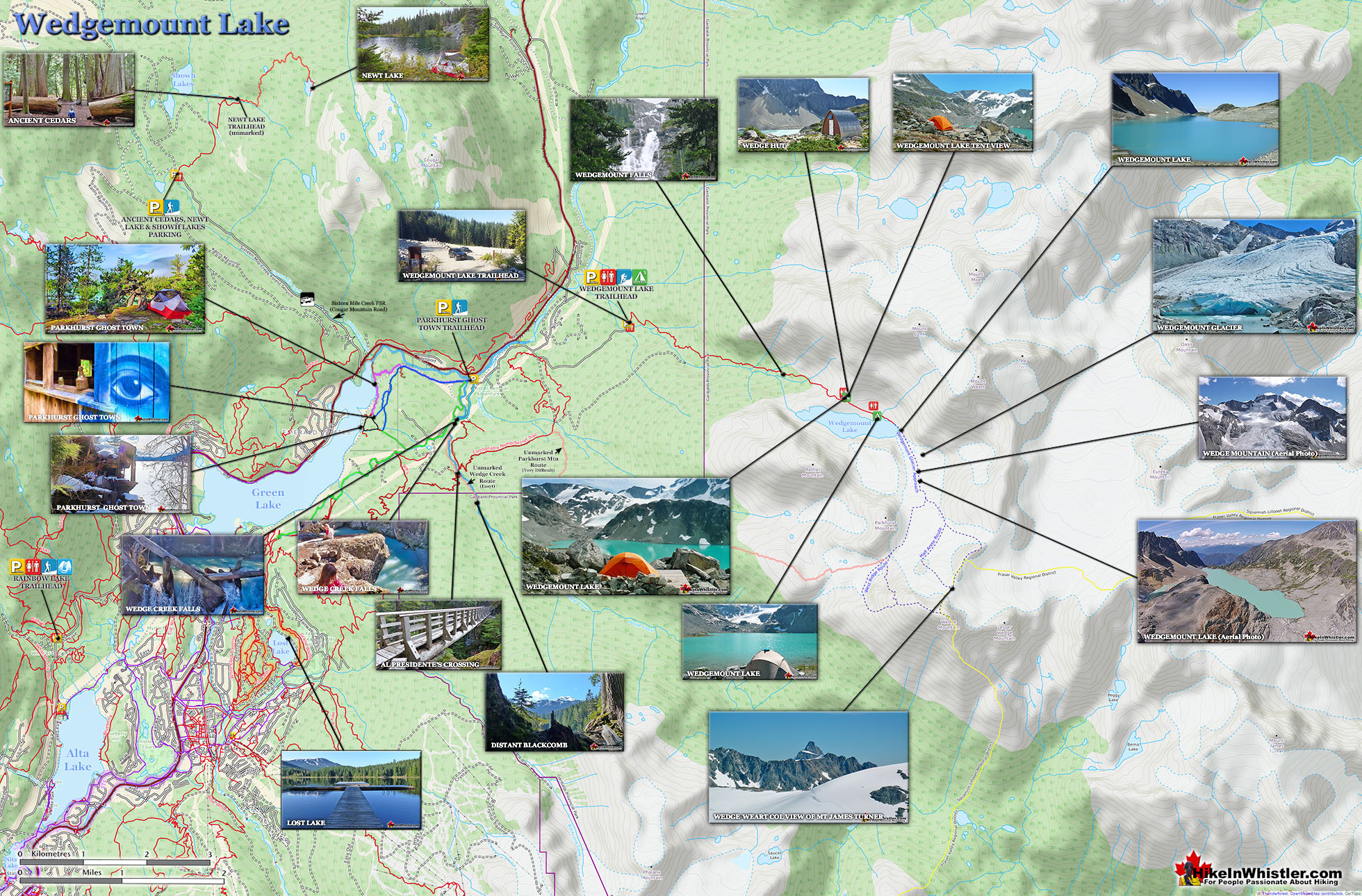
In all Wedgemount Lake has 20 of these tent areas. Most are wooden, but several down by the lake shore are gravel, yet every bit as nice. Due to a big snow winter, the Wedgemount Lake trail was very difficult to hike due to snow well into June 2017! Wedgemount Lake is one of the most spectacular hikes in Garibaldi Park. Though it is a relentlessly exhausting, steep hike, it is mercifully short at only 7 kilometres (one way). The elevation gain in that short distance is over 1200 metres which makes it a much steeper hike than all the other Whistler area hiking trails. Compared with other Whistler hikes, Wedgemount Lake is half the roundtrip distance of either Black Tusk or Panorama Ridge, for example, at 13.5 kilometres and 15 kilometres respectively (one way). At a fast hiking pace you can reach Wedgemount Lake from the trailhead in just an hour and a half but at a leisurely or backpack laden pace you will likely take over two hours. The trail is well marked and well used. The steepness of the trail doesn't require any technical skill, however that last kilometre before the lake you will be scrambling on all fours quite a bit. The elevation gain makes a tremendous difference when carrying a heavy backpack and unprepared for the exertion. There is hardly a section of the trail that is not steeply uphill. The first 15 minutes takes you into the deep forest as you run along Wedgemount Creek. This crashing creek can be heard from quite a distance and gives you a hint of the steepness of the trail to come.
Wedgemount Lake Hiking Trail Map
The source of Wedgemount Creek is of course Wedgemount Lake which tumbles down almost 300 metres in the spectacular Wedgemount Falls. You will be able to see Wedgemount Falls around the 5 kilometre mark along the trail. Unfortunately, it is far off to the right in the distance. Despite the distance, you will hear it loud and clear and occasionally get a great, though distant, view of it.

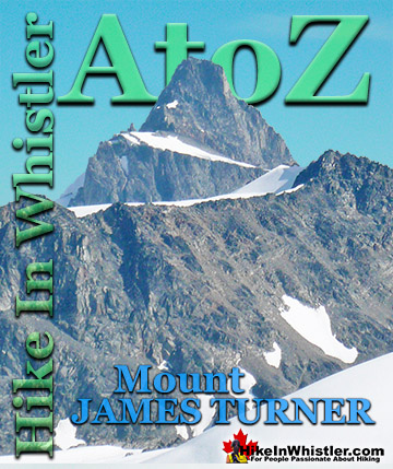
One of the defining features of Garibaldi Park, and Wedgemount Lake in particular, is the staggering number of branching hikes from the main destination of the lake itself. For many, Wedgemount Lake and the Wedge Hut is the base for hikes to Wedge Mountain, Mount Cook, Mount Weart, Mount Moe, Mount James Turner and Mount Currie in Pemberton, crossing glaciers such as Wedgemount Glacier, Weart Glacier, Armchair Glacier, Mystery Glacier and the Needles and Chaos Glacier to name a few. Dozens of unforgettable peaks can be reached from this quiet little hut overlooking this perfect, turquoise lake. In short, if you were to design a paradise in the mountains, Wedgemount Lake would be the standard to which all others would pale. The sheltered valley, beautiful turquoise lake, wonderfully huge glacier across the valley and brutally jagged mountains all around all contribute to making Wedgemount Lake something special. It's challenging and exhausting to hike to and an absolute paradise to relax in. Down by the lakeside you can actually find two recliner chairs, built out of the rocks by the lake. Such a perfect way to enjoy the sun rising over the not-so-distant glacier across the lake.


More Wedgemount Lake Hiking Info...
More Whistler & Garibaldi Park Hiking Maps!
Sproatt West Maps
Rainbow Falls Maps
Madeley Lake Maps
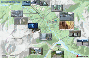
Keyhole Hot Springs Maps

Whistler & Garibaldi Park Glossary A to Z


The Best Whistler & Garibaldi Park Hiking Trails!