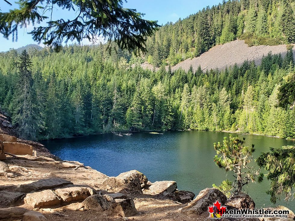
![]() Logger's Lake is an amazing little lake hidden up in the deep forest above the more well known Cheakamus River. The lake, almost unbelievably exists in a long extinct volcano. However, as soon as you see the lake up close, you quickly come to believe it. The lake sits in an almost cartoonish looking, volcano-shaped bowl, with one side of the bowl a crumbling array of fridge sized boulders leading down to the lake.
Logger's Lake is an amazing little lake hidden up in the deep forest above the more well known Cheakamus River. The lake, almost unbelievably exists in a long extinct volcano. However, as soon as you see the lake up close, you quickly come to believe it. The lake sits in an almost cartoonish looking, volcano-shaped bowl, with one side of the bowl a crumbling array of fridge sized boulders leading down to the lake.
 Nice place to escape from the world
- Surreal look inside an old volcano
- Best lake in Whistler for swimming
- Warmest(least cold) lake in Whistler
- Very dog friendly wilderness
- Many side trails to amazing places
- Most trails are seldom hiked
- Cheakamus River trails nearby
- Interesting geology around the lake
 Camping & Fires not permitted
Whistler & Garibaldi Hiking
![]() Alexander Falls
Alexander Falls ![]() Ancient Cedars
Ancient Cedars ![]() Black Tusk
Black Tusk ![]() Blackcomb Mountain
Blackcomb Mountain ![]() Brandywine Falls
Brandywine Falls ![]() Brandywine Meadows
Brandywine Meadows ![]() Brew Lake
Brew Lake ![]() Callaghan Lake
Callaghan Lake ![]() Cheakamus Lake
Cheakamus Lake ![]() Cheakamus River
Cheakamus River ![]() Cirque Lake
Cirque Lake ![]() Flank Trail
Flank Trail ![]() Garibaldi Lake
Garibaldi Lake ![]() Garibaldi Park
Garibaldi Park ![]() Helm Creek
Helm Creek ![]() Jane Lakes
Jane Lakes ![]() Joffre Lakes
Joffre Lakes ![]() Keyhole Hot Springs
Keyhole Hot Springs ![]() Logger’s Lake
Logger’s Lake ![]() Madeley Lake
Madeley Lake ![]() Meager Hot Springs
Meager Hot Springs ![]() Nairn Falls
Nairn Falls ![]() Newt Lake
Newt Lake ![]() Panorama Ridge
Panorama Ridge ![]() Parkhurst Ghost Town
Parkhurst Ghost Town ![]() Rainbow Falls
Rainbow Falls ![]() Rainbow Lake
Rainbow Lake ![]() Ring Lake
Ring Lake ![]() Russet Lake
Russet Lake ![]() Sea to Sky Trail
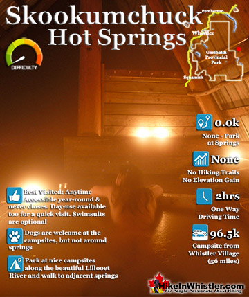
Sea to Sky Trail ![]() Skookumchuck Hot Springs
Skookumchuck Hot Springs ![]() Sloquet Hot Springs
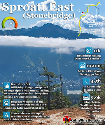
Sloquet Hot Springs ![]() Sproatt East
Sproatt East ![]() Sproatt West
Sproatt West ![]() Taylor Meadows
Taylor Meadows ![]() Train Wreck
Train Wreck ![]() Wedgemount Lake
Wedgemount Lake ![]() Whistler Mountain
Whistler Mountain
![]() January
January ![]() February
February ![]() March
March ![]() April
April ![]() May
May ![]() June
June ![]() July
July ![]() August
August ![]() September
September ![]() October
October ![]() November
November ![]() December
December
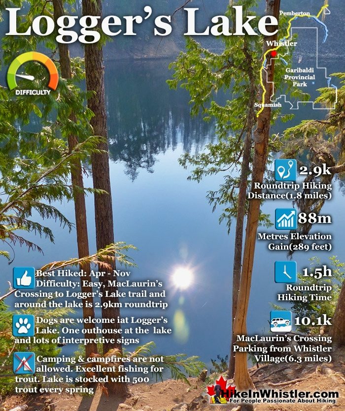
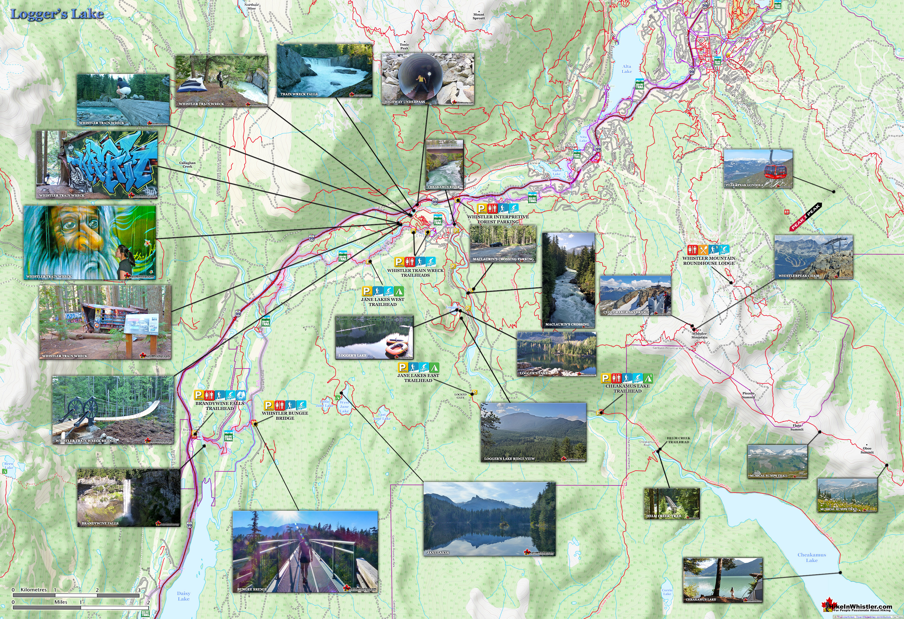
The crater that Logger's Lake sits in was a volcano that pushed through the glacial ice in this valley about 10000 years ago. As the lava cooled it formed the wonderful basalt ridge that is crumbling into valley. As Logger's Lake sits deep in this ancient volcano's vent, it is sheltered from the wind and soaks up the suns rays into the dark boulders all around. As a result makes it the warmest lake in Whistler, though most other lakes around are glacier fed(via rivers and creeks), so the comparison is not entirely fair. The surrounding cliffs and forest also add to the tranquility of the lake. Located a bit off the radar for most and requiring a short logging road drive and then a very steep, but very short hike to get to also contributes to its serenity. In 2021 a massive construction project began in Cheakamus Crossing and the access road to the Logger's Lake parking area is blocked by a gate and vehicle access to the trailhead will probably not reopen until 2024. There are plenty of trails that get you to the trailhead and various places you can park that are reasonably close. The unmarked parking area near MacLaurin's Crossing is the closest at just 664 metres from the Logger's Lake trailhead. This is a great option as almost the entire 664 metres is scenic as you cross the beautiful Cheakamus River and then hike alongside the river through a nice forest trail. You can also park at other locations before and after MacLaurin's Crossing on the Cheakamus Lake FSR. The main parking lot to Whistler Interpretive Forest just off the Sea to Sky Highway is where most visitors to Logger's Lake seem to park these days, though it adds another 3.1 kilometres to get to MacLaurin's Crossing.
Logger's Lake is Amazing!
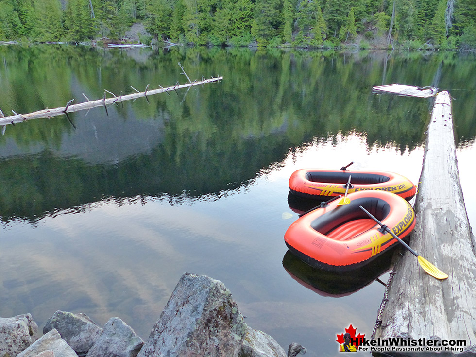
Logger's Lake is fantastic for so many reasons. Because it is in an extinct volcano you see wonderful geology everywhere you look and along one side of the lake you see columnar jointing in the cliff face where lava collided with a glacier. The Crater Rim trail takes you up and around the ancient volcano and you get incredible views of Logger's Lake as well as the surrounding valley. There are easy trails that wrap around the lake, both along the shore and up in the forest. Occasionally you come to a beautiful viewpoint with an elaborate information board describing what you see. Everywhere you wander along the trails you seem to come to some beautiful, secluded spot in the midst of paradise. The trail that hugs the far shore of the lake is very fun to hike and quite beautiful. Logger's Lake is the best lake in Whistler for swimming, not only because it is the warmest(least cold), but also the far edge of the lake is immediately deep so you can jump in right from the shore. Here are 8 reasons why Logger's Lake is amazing.
Logger's Lake Sits in an Extinct Volcano!

Logger's Lake Has Easy Trails to Wonderful Views!

Interesting Geology Where Lava Met the Glacier!

Logger's Lake Viewpoints With Interpretive Boards!

Hike the Crater Rim of an Ancient Volcano!

Logger's Lake Has Secluded Viewpoints Along the Rim of the Volcano!

Beautiful Shore Trail Around Logger's Lake!

Logger's Lake is the Best Swimming Lake in Whistler!

Parking and Trails Map to Logger's Lake
![]() With construction in Cheakamus Crossing blocking driving access to the Logger's Lake trailhead parking until at least 2024, you now have to park further away and hike in. Most park in the big Whistler Interpretive Forest parking lot just off the Sea to Sky Highway and hike 3.9 kilometres to Logger's Lake which takes about an hour. A good alternative if you want to park closer is to park at the small, unmarked parking area near MacLaurin's Crossing a couple kilometres up the Cheakamus Lake FSR. This is an excellent option and the hike to Logger's Lake is just 1 kilometre and only takes about 20 minutes. At Logger's Lake you then can continue on the easy Logger's Lake trail which loops around the lake in just 1 kilometre, or venture up the more challenging Crater Rim trail which is also a loop trail which brings you back to the lake in 4 kilometres.
With construction in Cheakamus Crossing blocking driving access to the Logger's Lake trailhead parking until at least 2024, you now have to park further away and hike in. Most park in the big Whistler Interpretive Forest parking lot just off the Sea to Sky Highway and hike 3.9 kilometres to Logger's Lake which takes about an hour. A good alternative if you want to park closer is to park at the small, unmarked parking area near MacLaurin's Crossing a couple kilometres up the Cheakamus Lake FSR. This is an excellent option and the hike to Logger's Lake is just 1 kilometre and only takes about 20 minutes. At Logger's Lake you then can continue on the easy Logger's Lake trail which loops around the lake in just 1 kilometre, or venture up the more challenging Crater Rim trail which is also a loop trail which brings you back to the lake in 4 kilometres.

Whistler Interpretive Forest Parking to Logger's Lake: 3.9km
![]()
![]() From the Whistler Interpretive Forest parking you first have to hike the short and easy Enter Riverside trail for 584 metres where it comes out at the Cheakamus Lake FSR. Look for the Farside trailhead across the road, keeping to the left side of Cheakamus River. The beautiful Farside trail runs alongside Cheakamus River for 2.5 kilometres to the wonderful MacLaurin's Crossing bridge. Cross the bridge and turn left onto the Riverside trail which continues along the other side of Cheakamus River. In just 500 metres the trail emerges from the forest at the parking lot for Logger's Lake where you will see the Logger's Lake trailhead next to the big yellow gate across the gravel road. The short, but steep Logger's Lake trail reaches the lake in just 336m. From the Whistler Interpretive Forest parking to Logger's Lake is 3.9 kilometres and takes most a little over an hour to hike.
From the Whistler Interpretive Forest parking you first have to hike the short and easy Enter Riverside trail for 584 metres where it comes out at the Cheakamus Lake FSR. Look for the Farside trailhead across the road, keeping to the left side of Cheakamus River. The beautiful Farside trail runs alongside Cheakamus River for 2.5 kilometres to the wonderful MacLaurin's Crossing bridge. Cross the bridge and turn left onto the Riverside trail which continues along the other side of Cheakamus River. In just 500 metres the trail emerges from the forest at the parking lot for Logger's Lake where you will see the Logger's Lake trailhead next to the big yellow gate across the gravel road. The short, but steep Logger's Lake trail reaches the lake in just 336m. From the Whistler Interpretive Forest parking to Logger's Lake is 3.9 kilometres and takes most a little over an hour to hike.
Whistler Interpretive Forest Parking: 3.9km to Logger's Lake

MacLaurin's Crossing Parking to Logger's Lake: 1km
![]()
![]() If you want to park as close as possible to the Logger's Lake trailhead, the best parking is found along the Cheakamus Lake FSR at the unmarked parking area for MacLaurin's Crossing, shown on the map above and pictured below. This gets you just 1 kilometre from Logger's Lake, and is a nice and easy route that crosses the beautiful MacLaurin's Crossing bridge, over Cheakamus River then along the easy Riverside trail to the Logger's Lake parking area. The Logger's Lake trail then takes you to Logger's Lake in just 336 metres. From your car to the lake takes only about 15 minutes to hike and is fun, easy and scenic the entire way.
If you want to park as close as possible to the Logger's Lake trailhead, the best parking is found along the Cheakamus Lake FSR at the unmarked parking area for MacLaurin's Crossing, shown on the map above and pictured below. This gets you just 1 kilometre from Logger's Lake, and is a nice and easy route that crosses the beautiful MacLaurin's Crossing bridge, over Cheakamus River then along the easy Riverside trail to the Logger's Lake parking area. The Logger's Lake trail then takes you to Logger's Lake in just 336 metres. From your car to the lake takes only about 15 minutes to hike and is fun, easy and scenic the entire way.
MacLaurin's Crossing Parking/Trailhead: 1km to Logger's Lake

MacLaurin's Crossing Bridge to Logger's Lake

MacLaurin's Crossing View of Cheakamus River

Logger's Lake Trails Map
![]() Logger's Lake has quite a network of interconnected trails which can be done in a variety of ways. Logger's Lake trail is the easiest and most popular trail that runs from the Logger's Lake trailhead up and around the lake. The loop around Logger's Lake is under one kilometre long and is quite easy. Along the way you will pass along the rocky shore on one side and the nice forest trail on the other side. The Logger's Lake trail around the lake also has a shoreline trail that skirts the edge of the water and is considerably more scenic than the main trail. This shoreline trail takes you past some amazing places to swim. Another popular trail at Logger's Lake is the Crater Rim trail which takes you up and around the rim of the the ancient volcano that was active here about 10000 years ago. This challenging trail branches off from the main Logger's Lake trail and ascends quickly up to an amazing view over the lake. Most visitors to Logger's Lake just hike this short section to take in the view, then return back down to the main trail. If you do continue, the Crater Rim trail runs for 3 kilometres up and around the rim of the volcano then descends down to connect with the Lower Ridge trail which brings you back to the Logger's Lake trail in 780 metres.
Logger's Lake has quite a network of interconnected trails which can be done in a variety of ways. Logger's Lake trail is the easiest and most popular trail that runs from the Logger's Lake trailhead up and around the lake. The loop around Logger's Lake is under one kilometre long and is quite easy. Along the way you will pass along the rocky shore on one side and the nice forest trail on the other side. The Logger's Lake trail around the lake also has a shoreline trail that skirts the edge of the water and is considerably more scenic than the main trail. This shoreline trail takes you past some amazing places to swim. Another popular trail at Logger's Lake is the Crater Rim trail which takes you up and around the rim of the the ancient volcano that was active here about 10000 years ago. This challenging trail branches off from the main Logger's Lake trail and ascends quickly up to an amazing view over the lake. Most visitors to Logger's Lake just hike this short section to take in the view, then return back down to the main trail. If you do continue, the Crater Rim trail runs for 3 kilometres up and around the rim of the volcano then descends down to connect with the Lower Ridge trail which brings you back to the Logger's Lake trail in 780 metres.

Logger's Lake Trail Loops Around the Lake
If you park at MacLaurin's Crossing and hike the Logger's Lake trail which loops around the lake, the roundtrip hiking distance is 2.9km. The short and steep Logger's Lake trail climbs quickly up to the edge of the lake in just 336 metres. It then splits into a loop trail that runs around the lake in 866 metres. The loop trail around the lake splits into two parallel trails around the back side of the lake, shown on the map above. The inner trail branches off from the main trail at the top end of the lake as well as at the bottom end. This inner, shore trail is overgrown in places and not maintained, so you have to climb over some fallen trees and up and down some short, steep sections, but it's worth it to get to the beautiful places on the far side of the lake.
The Start of the Logger's Lake Trail

Logger's Lake Trail Along the Boulder Side

Logger's Lake Along the Far Shore

The Far Shore of Logger's Lake is Great for Swimming

Swimming Along the Far Shore of Logger's Lake

The Crater Rim Trail
The Crater Rim trail branches off from the Logger's Lake trail just a few metres before you reach the lake. The trail climbs quickly and you come to a great viewpoint overlooking the lake. Looking down over the edge of ridge you see the rocky shore of the lake where huge, angular pieces of the cliff you are standing on have fractured and fallen. The entire ridge you are standing on is fractured rock jutting out toward the lake in a strangely unnatural looking way. This angular rock was formed when lava cooled against ice. When this was an active volcano near the end of the last ice age it pushed through the glacier that was hundreds of metres thick. Rock forming like this is called columnar jointing and you see it everywhere around Whistler, even along the Sea to Sky Highway.
Logger's Lake Crater Rim Trailhead

Crater Rim Trail First Viewpoint

Logger's Lake Columnar Jointing

Steep and Rugged Crater Rim Trail Around Logger's Lake

Logger's Lake Crater Rim Trail Viewpoint

Crater Rim Trail Descent to Lower Ridge Trail

Lower Ridge Trail Boulder Field to Logger's Lake

Lower Ridge Trail Logger's Lake Trail Junction

Camping Prohibited Around Logger's Lake
![]() Although the trails around Logger's Lake and especially the basalt ridge above the lake look amazing for camping, the Interpretive Forest prohibits camping. The area is exceptionally dry as compared to the rest of the valley and the risk of forest fire may be part of the reason for this. Also, the Interpretive Forest is dedicated as an experimental "ecosystem-based managed forest" and the inclusion of campsites may add to the recreational popularity of the area making future logging of this forest to be seen by the public as undesirable. The Logger's Lake trails are part of the much larger network of trails known as the Whistler Interpretive Forest. Several named trails run throughout the forest and along the wild and crashing, Cheakamus River. The Riverside Trail and the Farside Trail are the two beautiful trails that run along either side of Cheakamus River. The Cheakamus River MacLaurin's Crossing suspension bridge is just a 5 minute hike from the parking area for Logger's Lake. The suspension bridge is one end a 4 kilometre circle route that is a great way to see this amazing river. Check out free places to camp in Whistler here.
Although the trails around Logger's Lake and especially the basalt ridge above the lake look amazing for camping, the Interpretive Forest prohibits camping. The area is exceptionally dry as compared to the rest of the valley and the risk of forest fire may be part of the reason for this. Also, the Interpretive Forest is dedicated as an experimental "ecosystem-based managed forest" and the inclusion of campsites may add to the recreational popularity of the area making future logging of this forest to be seen by the public as undesirable. The Logger's Lake trails are part of the much larger network of trails known as the Whistler Interpretive Forest. Several named trails run throughout the forest and along the wild and crashing, Cheakamus River. The Riverside Trail and the Farside Trail are the two beautiful trails that run along either side of Cheakamus River. The Cheakamus River MacLaurin's Crossing suspension bridge is just a 5 minute hike from the parking area for Logger's Lake. The suspension bridge is one end a 4 kilometre circle route that is a great way to see this amazing river. Check out free places to camp in Whistler here.
Facilities at Logger's Lake
![]() Aside from the one outhouse at Logger's Lake there are no facilities. This is quite nice as to maintain a wild and untouched feeling of the area. Cheakamus Crossing has a few eateries with washrooms. The HI Whistler Hostel has a very nice little coffee shop with a few things to eat and drink. It is worth checking out, not least for a glimpse at Athletes Village. This was name given to this neighbourhood for the 2010 Olympics as it accommodated hundreds of athletes. After the Olympics the new neighbourhood became Cheakamus Crossing and is growing rapidly with massive construction of new housing for Whistler's housing starved population. Cheakamus Crossing is also where you will find the trailhead to one of Whistler's most popular hikes, Whistler Train Wreck.
Aside from the one outhouse at Logger's Lake there are no facilities. This is quite nice as to maintain a wild and untouched feeling of the area. Cheakamus Crossing has a few eateries with washrooms. The HI Whistler Hostel has a very nice little coffee shop with a few things to eat and drink. It is worth checking out, not least for a glimpse at Athletes Village. This was name given to this neighbourhood for the 2010 Olympics as it accommodated hundreds of athletes. After the Olympics the new neighbourhood became Cheakamus Crossing and is growing rapidly with massive construction of new housing for Whistler's housing starved population. Cheakamus Crossing is also where you will find the trailhead to one of Whistler's most popular hikes, Whistler Train Wreck.
Restrictions and Concerns at Logger's Lake
![]()
![]()
![]() No fires are allowed in Whistler's Interpretive Forest as the danger of forest fires is very high. No motorised vehicles on the trails either. Camping is not allowed, however the Interpretive Forest covers quite a large area of wilderness with dozens of idyllic places to sneak a nights sleep in the wilderness. For legal campsite options you have to look further up the Cheakamus valley. Cheakamus Lake has two very nice, wilderness campsites(pay to use). Helm Creek campground is further up towards Black Tusk. These are both in Garibaldi Provincial Park, which is campsite friendly, but not dog or bike friendly. The Cal-Cheak Campground and Whistler RV Park & Campground are good options for pay camping and both located just down the highway.
No fires are allowed in Whistler's Interpretive Forest as the danger of forest fires is very high. No motorised vehicles on the trails either. Camping is not allowed, however the Interpretive Forest covers quite a large area of wilderness with dozens of idyllic places to sneak a nights sleep in the wilderness. For legal campsite options you have to look further up the Cheakamus valley. Cheakamus Lake has two very nice, wilderness campsites(pay to use). Helm Creek campground is further up towards Black Tusk. These are both in Garibaldi Provincial Park, which is campsite friendly, but not dog or bike friendly. The Cal-Cheak Campground and Whistler RV Park & Campground are good options for pay camping and both located just down the highway.
Wildlife at Logger's Lake
![]() The list of wildlife in the forests around Whistler is quite extensive. Black bears are sometimes seen close to Logger's Lake, but far more frequently on the trails emanating away from the lake and quite often along the Cheakamus River trails. Bears in and around Whistler are not something you should be overly concerned with, though of course you always have to be bear aware when hiking. There has never been an unprovoked bear attack in Whistler or Garibaldi Park as black bears do their best to avoid people. Be aware of your surroundings and if you round a bend and see a bear, just stop and edge back. If you give the bear some space he will wander off the trail and disappear into the wilderness. Other big mammals make their home in the vast wilderness around Logger's Lake, but are rarely seen. Mountain goats, deer, cougars, wolverines and grizzly bears have been known to range this area, but very rare to see, though in just the last couple years grizzly bears have been seen occasionally. In 2023 a grizzly bear was wandering around in Whistler Cay and in Rainbow Park and was quickly caught by conservation officers and airlifted and released several kilometres from Whistler.
The list of wildlife in the forests around Whistler is quite extensive. Black bears are sometimes seen close to Logger's Lake, but far more frequently on the trails emanating away from the lake and quite often along the Cheakamus River trails. Bears in and around Whistler are not something you should be overly concerned with, though of course you always have to be bear aware when hiking. There has never been an unprovoked bear attack in Whistler or Garibaldi Park as black bears do their best to avoid people. Be aware of your surroundings and if you round a bend and see a bear, just stop and edge back. If you give the bear some space he will wander off the trail and disappear into the wilderness. Other big mammals make their home in the vast wilderness around Logger's Lake, but are rarely seen. Mountain goats, deer, cougars, wolverines and grizzly bears have been known to range this area, but very rare to see, though in just the last couple years grizzly bears have been seen occasionally. In 2023 a grizzly bear was wandering around in Whistler Cay and in Rainbow Park and was quickly caught by conservation officers and airlifted and released several kilometres from Whistler.

Fishing is good at Logger's Lake and it is stocked with about rainbow trout every spring. Though small, you can consistently catch something by casting near the logs along the shore.
Parking & Trailhead Directions to Logger's Lake
![]()
![]()
![]() With construction in Cheakamus Crossing blocking vehicle access to the Logger's Lake trailhead parking there are two main alternatives. The big Whistler Interpretive Forest parking lot is one option, but the unmarked parking area along the Cheakamus Lake FSR is much closer. From Whistler Village drive south on the Sea to Sky Highway (99) for 7.9km, turn left onto Cheakamus Lake Road. Drive 400 metres and turn left onto Cheakamus Lake FSR. This is also the road that takes you to Cheakamus Lake. Drive 1.8km and look for the unmarked parking area for MacLaurin's Crossing on your right (pictured below). The unmarked trail, marked with a red arrow on the parking picture below takes you to the beautiful MacLaurin's Crossing bridge over Cheakamus River. After the bridge, turn left onto the Farside trail and hike to the Logger's Lake parking area and you will see the Logger's Lake trailhead. From the parking at MacLaurin's Crossing to Logger's Lake is just one kilometre and mostly easy, relaxing and scenic. From the Whistler Interpretive Forest parking the hiking distance to Logger's Lake is just under four kilometres.
With construction in Cheakamus Crossing blocking vehicle access to the Logger's Lake trailhead parking there are two main alternatives. The big Whistler Interpretive Forest parking lot is one option, but the unmarked parking area along the Cheakamus Lake FSR is much closer. From Whistler Village drive south on the Sea to Sky Highway (99) for 7.9km, turn left onto Cheakamus Lake Road. Drive 400 metres and turn left onto Cheakamus Lake FSR. This is also the road that takes you to Cheakamus Lake. Drive 1.8km and look for the unmarked parking area for MacLaurin's Crossing on your right (pictured below). The unmarked trail, marked with a red arrow on the parking picture below takes you to the beautiful MacLaurin's Crossing bridge over Cheakamus River. After the bridge, turn left onto the Farside trail and hike to the Logger's Lake parking area and you will see the Logger's Lake trailhead. From the parking at MacLaurin's Crossing to Logger's Lake is just one kilometre and mostly easy, relaxing and scenic. From the Whistler Interpretive Forest parking the hiking distance to Logger's Lake is just under four kilometres.

More Hiking Trails Near Logger's Lake
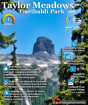
![]() Logger's Lake is located near Cheakamus River which has hiking trails on both sides of it that stretch quite far. The wonderful Sea to Sky Trail passes along Cheakamus River and through Cheakamus Crossing. A nice suspension bridge crosses Cheakamus River and takes you over to the surreal Whistler Train Wreck. Several wrecked train cars beautifully painted with graffiti murals are spread through the forest over an area about 400 metre long. From Logger's Lake, heading up to the source of Cheakamus River is Cheakamus Lake. Cheakamus Lake is a beautiful mountain lake that starts just 3 kilometres from the trailhead. The trail then continues along the shore of Cheakamus Lake for another 4 kilometres. Located in Garibaldi Provincial Park, Cheakamus Lake is one of the main trailhead access points to this beautiful park.
Logger's Lake is located near Cheakamus River which has hiking trails on both sides of it that stretch quite far. The wonderful Sea to Sky Trail passes along Cheakamus River and through Cheakamus Crossing. A nice suspension bridge crosses Cheakamus River and takes you over to the surreal Whistler Train Wreck. Several wrecked train cars beautifully painted with graffiti murals are spread through the forest over an area about 400 metre long. From Logger's Lake, heading up to the source of Cheakamus River is Cheakamus Lake. Cheakamus Lake is a beautiful mountain lake that starts just 3 kilometres from the trailhead. The trail then continues along the shore of Cheakamus Lake for another 4 kilometres. Located in Garibaldi Provincial Park, Cheakamus Lake is one of the main trailhead access points to this beautiful park.

Cheakamus River - Trails Near Logger's Lake
![]() Cheakamus River is a beautiful, crashing, turquoise coloured river that flows from Cheakamus Lake, through Whistler Interpretive Forest at Cheakamus Crossing, then down past Brandywine Falls to Daisy Lake. Also a popular kayaking route, the main attraction to Cheakamus River is the wonderful and quite extensive network of hiking and biking trails that run along either side of it. The Riverside trail and the Farside trail run on either side of Cheakamus River and connect at both ends by bridges. Connecting to the Riverside trail is the short trail to Logger's Lake, which in turn is surrounded by more hiking and biking trails. The Lake Loop trail, Crater Rim trail, the Ridge trail, Upper Ridge trail, and the Lower Ridge trail. On the Farside trail along Cheakamus River you can connect to Cheakamus Road(gravel road) and hike 6 kilometres up to the Cheakamus Lake trailhead. On the other side of the neighbourhood of Cheakamus Crossing, which Cheakamus River bends around keeping the Sea to Sky Highway and train tracks on its opposite side, you find still more hiking and biking trails. Trash trail hugs the river all the way to the beautiful bridge to Whistler Train Wreck. Or, continue past the bridge to connect with the Sea to Sky trail. For the most part, however, if you are talking about the Cheakamus River trails you are likely talking about the Farside and Riverside trails in Whistler's Interpretive Forest. Continued here...
Cheakamus River is a beautiful, crashing, turquoise coloured river that flows from Cheakamus Lake, through Whistler Interpretive Forest at Cheakamus Crossing, then down past Brandywine Falls to Daisy Lake. Also a popular kayaking route, the main attraction to Cheakamus River is the wonderful and quite extensive network of hiking and biking trails that run along either side of it. The Riverside trail and the Farside trail run on either side of Cheakamus River and connect at both ends by bridges. Connecting to the Riverside trail is the short trail to Logger's Lake, which in turn is surrounded by more hiking and biking trails. The Lake Loop trail, Crater Rim trail, the Ridge trail, Upper Ridge trail, and the Lower Ridge trail. On the Farside trail along Cheakamus River you can connect to Cheakamus Road(gravel road) and hike 6 kilometres up to the Cheakamus Lake trailhead. On the other side of the neighbourhood of Cheakamus Crossing, which Cheakamus River bends around keeping the Sea to Sky Highway and train tracks on its opposite side, you find still more hiking and biking trails. Trash trail hugs the river all the way to the beautiful bridge to Whistler Train Wreck. Or, continue past the bridge to connect with the Sea to Sky trail. For the most part, however, if you are talking about the Cheakamus River trails you are likely talking about the Farside and Riverside trails in Whistler's Interpretive Forest. Continued here...
Train Wreck - Trails Near Logger's Lake
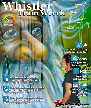
![]() The trail to Whistler Train Wreck is an easy, yet varied route through deep forest, across a great suspension bridge over Cheakamus River, to a stunning array of wrecked train cars. The trail from your car to the wrecks only takes about 15 minutes, however once you reach one wreck, you see another, then another. There are seven wrecks in total that are spread over an area about 400 metres long. Along with the surreal train wrecks painted with stunning murals, you find yourself in a thick forest that runs along Cheakamus River. Cheakamus River is a beautiful, wild and crashing river that snakes past the train wrecks. Numerous side trails take you to some marvellous viewpoints, several metres above the rushing water below. If you follow a trail past the wrecks(heading north or in the direction of Whistler Village) you will emerge at the train tracks. If you are adventurous you will then walk along, beside the tracks for a couple hundred metres and some truly breathtaking views of Cheakamus River. Continued here...
The trail to Whistler Train Wreck is an easy, yet varied route through deep forest, across a great suspension bridge over Cheakamus River, to a stunning array of wrecked train cars. The trail from your car to the wrecks only takes about 15 minutes, however once you reach one wreck, you see another, then another. There are seven wrecks in total that are spread over an area about 400 metres long. Along with the surreal train wrecks painted with stunning murals, you find yourself in a thick forest that runs along Cheakamus River. Cheakamus River is a beautiful, wild and crashing river that snakes past the train wrecks. Numerous side trails take you to some marvellous viewpoints, several metres above the rushing water below. If you follow a trail past the wrecks(heading north or in the direction of Whistler Village) you will emerge at the train tracks. If you are adventurous you will then walk along, beside the tracks for a couple hundred metres and some truly breathtaking views of Cheakamus River. Continued here...

Cheakamus Lake - Trails Near Logger's Lake
![]() Cheakamus Lake is a wonderfully relaxing way to get in the wilderness easily and quickly from Whistler Village. The trail begins on the far side of Whistler Mountain, 8 kilometres from the Sea to Sky Highway at Cheakamus Crossing across from Function Junction. This 8 kilometre stretch of logging road is fairly bumpy and potholed, but does have the benefit of allowing you to drive the elevation gain instead of hiking it. You can easily manage this road in a car, however carefully and very slowly in parts. Once you reach the trailhead/parking the entire 7 kilometre hiking trail to the end of the maintained Cheakamus Lake trail has barely any elevation gain. Just plenty of gradual inclines and declines along the winding route. In fact, this makes it one of the few trails in Whistler and Garibaldi Park that can boast that. The nearby Garibaldi Lake trail and the Wedgemount Lake trail make you work for the views, however, the Cheakamus Lake trail hardly makes you work at all. The trail to Cheakamus Lake takes you through an amazing forest of giant cedars that fill the forest with their amazing aroma. This forest is so packed with ancient giants that year to year the trail is adjusted by a monster of a tree fallen across the trail during some winter storm. Sometimes the trail bends around these behemoths, but more often they are laboriously chainsawed by BC Parks staff. The more enormous of these remain as fixtures of the trail. Either edging the trail or as a mighty obstacle to climb over. Continued here...
Cheakamus Lake is a wonderfully relaxing way to get in the wilderness easily and quickly from Whistler Village. The trail begins on the far side of Whistler Mountain, 8 kilometres from the Sea to Sky Highway at Cheakamus Crossing across from Function Junction. This 8 kilometre stretch of logging road is fairly bumpy and potholed, but does have the benefit of allowing you to drive the elevation gain instead of hiking it. You can easily manage this road in a car, however carefully and very slowly in parts. Once you reach the trailhead/parking the entire 7 kilometre hiking trail to the end of the maintained Cheakamus Lake trail has barely any elevation gain. Just plenty of gradual inclines and declines along the winding route. In fact, this makes it one of the few trails in Whistler and Garibaldi Park that can boast that. The nearby Garibaldi Lake trail and the Wedgemount Lake trail make you work for the views, however, the Cheakamus Lake trail hardly makes you work at all. The trail to Cheakamus Lake takes you through an amazing forest of giant cedars that fill the forest with their amazing aroma. This forest is so packed with ancient giants that year to year the trail is adjusted by a monster of a tree fallen across the trail during some winter storm. Sometimes the trail bends around these behemoths, but more often they are laboriously chainsawed by BC Parks staff. The more enormous of these remain as fixtures of the trail. Either edging the trail or as a mighty obstacle to climb over. Continued here...

Sea to Sky Trail - Trails Near Logger's Lake
![]() The Sea to Sky Trail is a 180 kilometre multi-use trail that runs from Squamish to D'Arcy. The trail is still under construction in many parts, however, the amazing route through Whistler is finally in place. The Whistler section of the Sea to Sky Trail is 33 kilometres long between Brandywine Falls Provincial Park and WedgeWoods Estates just north of Green Lake(north of Whistler Village). The 33 kilometre Whistler section of the Sea to Sky Trail is either paved, dirt or crushed rock and often very wide. Much of the trail just north and south of Whistler Village is wide, two lanes and paved with plenty of signs and occasional mapboards. North of Whistler Village the trail can be challenging with several hills as it rises above and beyond Parkhurst Ghost Town. South of Whistler, the paved trail ends at Cheakamus Crossing and becomes a narrow at times dirt trail with some wider sections of crushed rock. This beautiful section follows Cheakamus River making four dramatically beautiful river crossings. The Cal-Cheak area south of Cheakamus Crossing is more challenging and sometimes narrow and hilly, dirt trails. South of Cal-Cheak the forest opens up and the trail widens to the luxurious feeling, wide and hard packed gravel all the way to Brandywine Falls Provincial Park where the trail joins with the Sea to Sky Highway. The Whistler section of the Sea to Sky Trail passes near and through an amazing array of whistler sights. The always impressive Brandywine Falls Provincial Park at the southern end of the 33 kilometre area shown here. Heading north from Brandywine Falls you cross the huge bungee jumping bridge that spans the enormous chasm over the Cheakamus River. Soon after you cross the suspension bridge at the Cal-Cheak Recreation area. Continued here...
The Sea to Sky Trail is a 180 kilometre multi-use trail that runs from Squamish to D'Arcy. The trail is still under construction in many parts, however, the amazing route through Whistler is finally in place. The Whistler section of the Sea to Sky Trail is 33 kilometres long between Brandywine Falls Provincial Park and WedgeWoods Estates just north of Green Lake(north of Whistler Village). The 33 kilometre Whistler section of the Sea to Sky Trail is either paved, dirt or crushed rock and often very wide. Much of the trail just north and south of Whistler Village is wide, two lanes and paved with plenty of signs and occasional mapboards. North of Whistler Village the trail can be challenging with several hills as it rises above and beyond Parkhurst Ghost Town. South of Whistler, the paved trail ends at Cheakamus Crossing and becomes a narrow at times dirt trail with some wider sections of crushed rock. This beautiful section follows Cheakamus River making four dramatically beautiful river crossings. The Cal-Cheak area south of Cheakamus Crossing is more challenging and sometimes narrow and hilly, dirt trails. South of Cal-Cheak the forest opens up and the trail widens to the luxurious feeling, wide and hard packed gravel all the way to Brandywine Falls Provincial Park where the trail joins with the Sea to Sky Highway. The Whistler section of the Sea to Sky Trail passes near and through an amazing array of whistler sights. The always impressive Brandywine Falls Provincial Park at the southern end of the 33 kilometre area shown here. Heading north from Brandywine Falls you cross the huge bungee jumping bridge that spans the enormous chasm over the Cheakamus River. Soon after you cross the suspension bridge at the Cal-Cheak Recreation area. Continued here...

Whistler's Best Hiking Trails!
Whistler & Garibaldi Park Best Hiking by Month!


Explore BC Hiking Destinations!

Whistler Hiking Trails

Squamish Hiking Trails

Vancouver Hiking Trails

Clayoquot Hiking Trails
Victoria Hiking Trails

