![]() Logger's Lake is an amazing little lake hidden up in the deep forest above the more well known Cheakamus River. The lake, almost unbelievably exists in a long extinct volcano. However, as soon as you see the lake up close, you quickly come to believe it. The lake sits in an almost cartoonish looking, volcano-shaped bowl, with one side of the bowl a crumbling array of fridge sized boulders leading down to the lake.
Logger's Lake is an amazing little lake hidden up in the deep forest above the more well known Cheakamus River. The lake, almost unbelievably exists in a long extinct volcano. However, as soon as you see the lake up close, you quickly come to believe it. The lake sits in an almost cartoonish looking, volcano-shaped bowl, with one side of the bowl a crumbling array of fridge sized boulders leading down to the lake.
 Nice place to escape from the world
- Surreal look inside an old volcano
- Best lake in Whistler for swimming
- Warmest(least cold) lake in Whistler
- Nice place to escape from the world
- Many side trails to amazing places
- Most trails are seldom hiked
- Cheakamus River trails nearby
- Interesting geology around the lake
 Camping & Fires not permitted
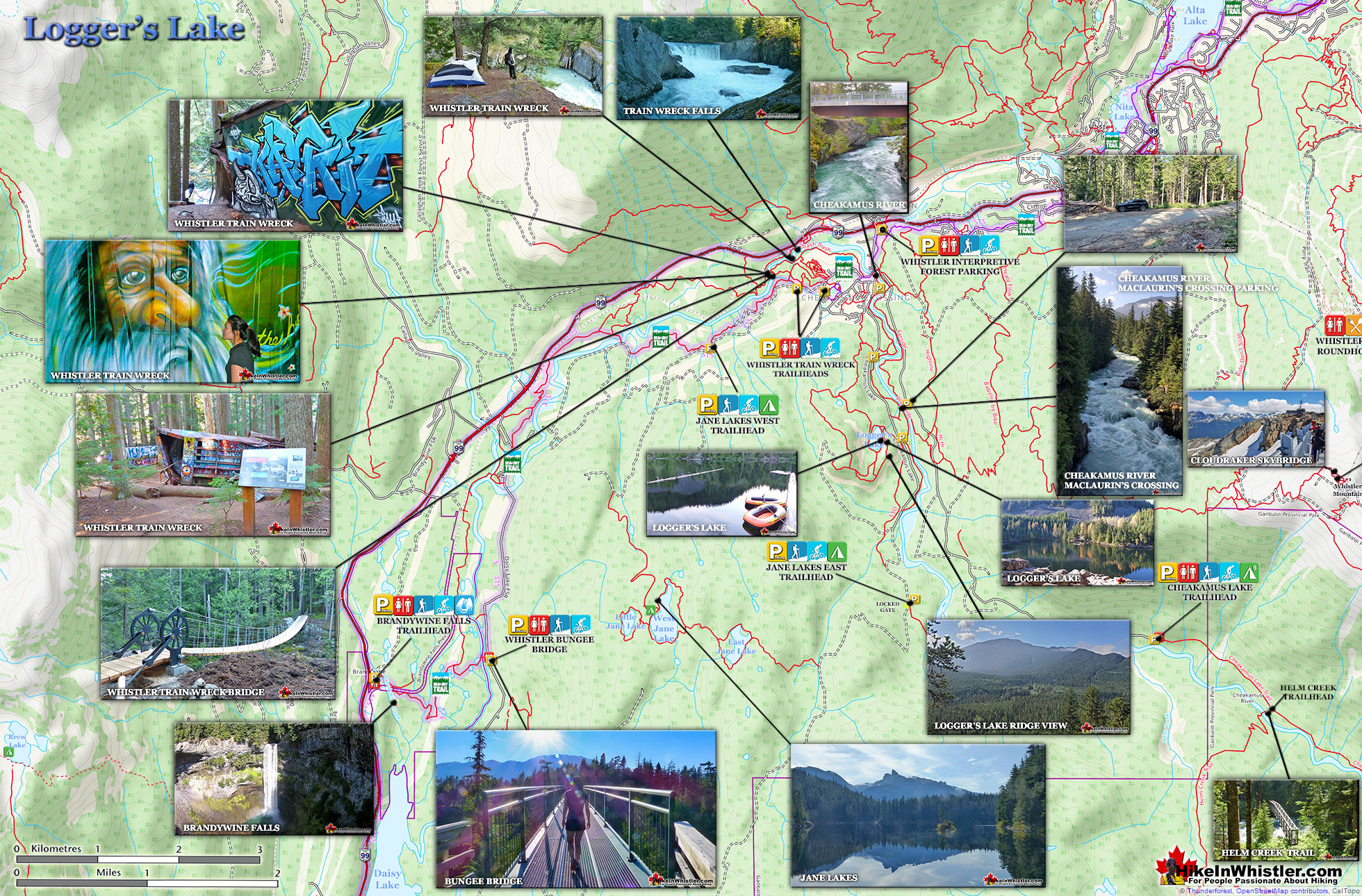
The crater that Logger's Lake sits in was a volcano that pushed through the glacial ice in this valley about 10000 years ago. As the lava cooled it formed the wonderful basalt ridge that is crumbling into valley. As Logger's Lake sits deep in this ancient volcano's vent, it is sheltered from the wind and soaks up the suns rays into the dark boulders all around. As a result makes it the warmest lake in Whistler, though most other lakes around are glacier fed(via rivers and creeks), so the comparison is not entirely fair. The surrounding cliffs and forest also add to the tranquility of the lake. Located a bit off the radar for most and requiring a short logging road drive and then a very steep, but very short hike to get to also contributes to its serenity. In 2021 a massive construction project began in Cheakamus Crossing and the access road to the Logger's Lake parking area is blocked by a gate and vehicle access to the trailhead will probably not reopen until 2024. There are plenty of trails that get you to the trailhead and various places you can park that are reasonably close. The unmarked parking area near MacLaurin's Crossing is the closest at just 664 metres from the Logger's Lake trailhead. This is a great option as almost the entire 664 metres is scenic as you cross the beautiful Cheakamus River and then hike alongside the river through a nice forest trail. You can also park at other locations before and after MacLaurin's Crossing on the Cheakamus Lake FSR. The main parking lot to Whistler Interpretive Forest just off the Sea to Sky Highway is where most visitors to Logger's Lake seem to park these days, though it adds another 3.1 kilometres to get to MacLaurin's Crossing.
Trails to Logger's Lake Map
![]() With construction in Cheakamus Crossing blocking driving access to the Logger's Lake trailhead parking until at least 2024, you now have to park further away and hike in. Most park in the big Whistler Interpretive Forest parking lot just off the Sea to Sky Highway and hike or bike 3.6 kilometres to the trailhead. If you want to park as close as possible to the Logger's Lake trailhead, the best parking is found along the Cheakamus Lake FSR at the unmarked parking area for MacLaurin's Crossing, shown on the map below. This gets you just 664 metres from the trailhead and is a nice and easy route that crosses the beautiful MacLaurin's Crossing bridge over Cheakamus River then along the easy Riverside trail. Hiking or biking distance to Logger's Lake from the MacLaurins Crossing parking is 1 kilometre. If you start from the parking lot at Whistler Interpretive Forest the hiking or biking distance to Logger's Lake is about 4 kilometres.
With construction in Cheakamus Crossing blocking driving access to the Logger's Lake trailhead parking until at least 2024, you now have to park further away and hike in. Most park in the big Whistler Interpretive Forest parking lot just off the Sea to Sky Highway and hike or bike 3.6 kilometres to the trailhead. If you want to park as close as possible to the Logger's Lake trailhead, the best parking is found along the Cheakamus Lake FSR at the unmarked parking area for MacLaurin's Crossing, shown on the map below. This gets you just 664 metres from the trailhead and is a nice and easy route that crosses the beautiful MacLaurin's Crossing bridge over Cheakamus River then along the easy Riverside trail. Hiking or biking distance to Logger's Lake from the MacLaurins Crossing parking is 1 kilometre. If you start from the parking lot at Whistler Interpretive Forest the hiking or biking distance to Logger's Lake is about 4 kilometres.

Logger's Lake Trail Map
![]() Logger's Lake has quite a network of interconnected trails which can be done in a variety of ways. Logger's Lake trail is the easiest and most popular trail that runs from the Logger's Lake trailhead up and around the lake. The loop around Logger's Lake is under one kilometre long and is quite easy. Along the way you will pass along the rocky shore on one side and the nice forest trail on the other side. The Logger's Lake trail around the lake also has a shoreline trail that skirts the edge of the water and is considerably more scenic than the main trail. This shoreline trail takes you past some amazing places to swim. Another popular trail at Logger's Lake is the Crater Rim trail which takes you up and around the rim of the the ancient volcano that was active here about 10000 years ago. This challenging trail branches off from the main Logger's Lake trail and ascends quickly up to an amazing view over the lake. Most visitors to Logger's Lake just hike this short section to take in the view, then return back down to the main trail. If you do continue, the Crater Rim trail runs for 3 kilometres up and around the rim of the volcano then descends down to connect with the Lower Ridge trail which brings you back to the Logger's Lake trail in 780 metres.
Logger's Lake has quite a network of interconnected trails which can be done in a variety of ways. Logger's Lake trail is the easiest and most popular trail that runs from the Logger's Lake trailhead up and around the lake. The loop around Logger's Lake is under one kilometre long and is quite easy. Along the way you will pass along the rocky shore on one side and the nice forest trail on the other side. The Logger's Lake trail around the lake also has a shoreline trail that skirts the edge of the water and is considerably more scenic than the main trail. This shoreline trail takes you past some amazing places to swim. Another popular trail at Logger's Lake is the Crater Rim trail which takes you up and around the rim of the the ancient volcano that was active here about 10000 years ago. This challenging trail branches off from the main Logger's Lake trail and ascends quickly up to an amazing view over the lake. Most visitors to Logger's Lake just hike this short section to take in the view, then return back down to the main trail. If you do continue, the Crater Rim trail runs for 3 kilometres up and around the rim of the volcano then descends down to connect with the Lower Ridge trail which brings you back to the Logger's Lake trail in 780 metres.

Driving Directions to Logger's Lake Map
![]() With construction in Cheakamus Crossing blocking vehicle access to the Logger's Lake trailhead parking there are two main alternatives. The big Whistler Interpretive Forest parking lot is one option, but the unmarked parking area along the Cheakamus Lake FSR is much closer. From Whistler Village drive south on the Sea to Sky Highway (99) for 7.9km, turn left onto Cheakamus Lake Road. Drive 400 metres and turn left onto Cheakamus Lake FSR. This is also the road that takes you to Cheakamus Lake. Drive 1.8km and look for the unmarked parking area for MacLaurin's Crossing on your right (pictured below). The unmarked trail, marked with a red arrow on the parking picture below takes you to the beautiful MacLaurin's Crossing bridge over Cheakamus River. After the bridge, turn left onto the Farside trail and hike to the Logger's Lake parking area and you will see the Logger's Lake trailhead. From the parking at MacLaurin's Crossing to Logger's Lake is just one kilometre and mostly easy, relaxing and scenic. From the Whistler Interpretive Forest parking the hiking distance to Logger's Lake is just under four kilometres.
With construction in Cheakamus Crossing blocking vehicle access to the Logger's Lake trailhead parking there are two main alternatives. The big Whistler Interpretive Forest parking lot is one option, but the unmarked parking area along the Cheakamus Lake FSR is much closer. From Whistler Village drive south on the Sea to Sky Highway (99) for 7.9km, turn left onto Cheakamus Lake Road. Drive 400 metres and turn left onto Cheakamus Lake FSR. This is also the road that takes you to Cheakamus Lake. Drive 1.8km and look for the unmarked parking area for MacLaurin's Crossing on your right (pictured below). The unmarked trail, marked with a red arrow on the parking picture below takes you to the beautiful MacLaurin's Crossing bridge over Cheakamus River. After the bridge, turn left onto the Farside trail and hike to the Logger's Lake parking area and you will see the Logger's Lake trailhead. From the parking at MacLaurin's Crossing to Logger's Lake is just one kilometre and mostly easy, relaxing and scenic. From the Whistler Interpretive Forest parking the hiking distance to Logger's Lake is just under four kilometres.

Logger's Lake & Interpretive Forest Map
Logger's Lake is within Whistler's Interpretive Forest, which includes the Farside and Riverside trails that run along Cheakamus River as well as numerous other trails that branch off in all directions.

Logger's Lake Cheakamus Valley Map
![]() Logger's Lake is surrounded by by several amazing places to hike. Cheakamus Lake is just up the road from the MacLaurin's Crossing parking for Logger's Lake. Whistler Train Wreck is nearby with its trailhead in Cheakamus Crossing. Beautiful Jane Lake's is also close and accessible via two different trailheads. Just down the highway in Cal-Cheak you will find the beautiful Whistler Bungee Bridge with trails leading into Brandywine Falls Provincial Park.
Logger's Lake is surrounded by by several amazing places to hike. Cheakamus Lake is just up the road from the MacLaurin's Crossing parking for Logger's Lake. Whistler Train Wreck is nearby with its trailhead in Cheakamus Crossing. Beautiful Jane Lake's is also close and accessible via two different trailheads. Just down the highway in Cal-Cheak you will find the beautiful Whistler Bungee Bridge with trails leading into Brandywine Falls Provincial Park.

More Logger's Lake Info Here...
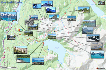
More Whistler & Garibaldi Park Hiking Maps!
Alexander Falls Maps
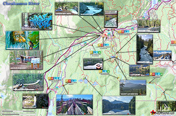
Cheakamus River Maps
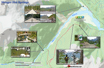
Meager Hot Springs Maps
Garibaldi Lake Maps

Whistler & Garibaldi Park Glossary A to Z

The Best Whistler & Garibaldi Park Hiking Trails!