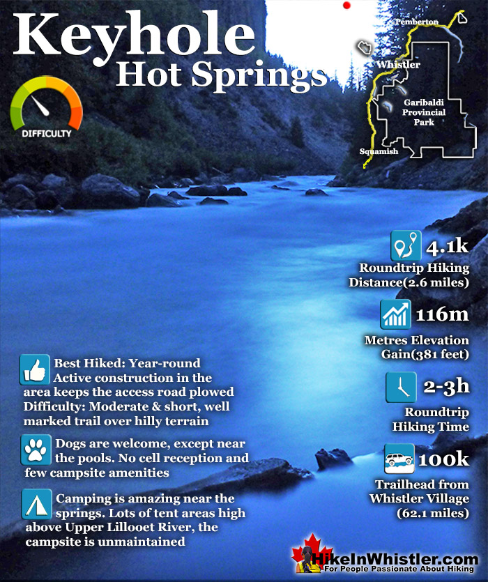
![]() Keyhole Hot Springs (aka Pebble Creek Hot Springs) is located 100 kilometres from Whistler (Village Gate Blvd). Though much of the drive to Keyhole is on logging roads, the route is driveable by most cars without any trouble. The massive Innergex hydroelectric project turned this once quiet wilderness into a war-zone in recent years. On the plus side, the old logging roads near Keyhole Hot Springs are now well maintained and smooth.
Keyhole Hot Springs (aka Pebble Creek Hot Springs) is located 100 kilometres from Whistler (Village Gate Blvd). Though much of the drive to Keyhole is on logging roads, the route is driveable by most cars without any trouble. The massive Innergex hydroelectric project turned this once quiet wilderness into a war-zone in recent years. On the plus side, the old logging roads near Keyhole Hot Springs are now well maintained and smooth.

 Beautiful drive to get there with lots of sights
- Pools at the edge of Upper Lillooet River
- Evidence of Meager's eruption 2400 years ago
- Wild & free place in a gorgeous setting
- Campsite is large, spread out & scenic
- Drive through the debris field from 2010
- Trail is packed with geological curiosities
- The impressive Keyhole Falls is nearby
- Upper Lillooet River is beautiful!
 Access Blocked by Ministry of Forests
Whistler & Garibaldi Hiking
![]() Alexander Falls
Alexander Falls ![]() Ancient Cedars
Ancient Cedars ![]() Black Tusk
Black Tusk ![]() Blackcomb Mountain
Blackcomb Mountain ![]() Brandywine Falls
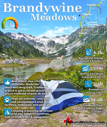
Brandywine Falls ![]() Brandywine Meadows
Brandywine Meadows ![]() Brew Lake
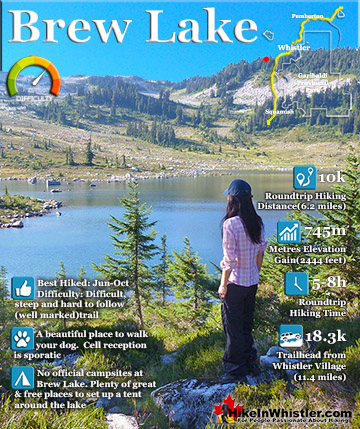
Brew Lake ![]() Callaghan Lake
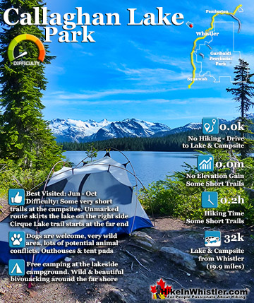
Callaghan Lake ![]() Cheakamus Lake
Cheakamus Lake ![]() Cheakamus River
Cheakamus River ![]() Cirque Lake
Cirque Lake ![]() Flank Trail
Flank Trail ![]() Garibaldi Lake
Garibaldi Lake ![]() Garibaldi Park
Garibaldi Park ![]() Helm Creek
Helm Creek ![]() Jane Lakes
Jane Lakes ![]() Joffre Lakes
Joffre Lakes ![]() Keyhole Hot Springs
Keyhole Hot Springs ![]() Logger’s Lake
Logger’s Lake ![]() Madeley Lake
Madeley Lake ![]() Meager Hot Springs
Meager Hot Springs ![]() Nairn Falls
Nairn Falls ![]() Newt Lake
Newt Lake ![]() Panorama Ridge
Panorama Ridge ![]() Parkhurst Ghost Town
Parkhurst Ghost Town ![]() Rainbow Falls
Rainbow Falls ![]() Rainbow Lake
Rainbow Lake ![]() Ring Lake
Ring Lake ![]() Russet Lake
Russet Lake ![]() Sea to Sky Trail
Sea to Sky Trail ![]() Skookumchuck Hot Springs
Skookumchuck Hot Springs ![]() Sloquet Hot Springs
Sloquet Hot Springs ![]() Sproatt East
Sproatt East ![]() Sproatt West
Sproatt West ![]() Taylor Meadows
Taylor Meadows ![]() Train Wreck
Train Wreck ![]() Wedgemount Lake
Wedgemount Lake ![]() Whistler Mountain
Whistler Mountain
![]() January
January ![]() February
February ![]() March
March ![]() April
April ![]() May
May ![]() June
June ![]() July
July ![]() August
August ![]() September
September ![]() October
October ![]() November
November ![]() December
December
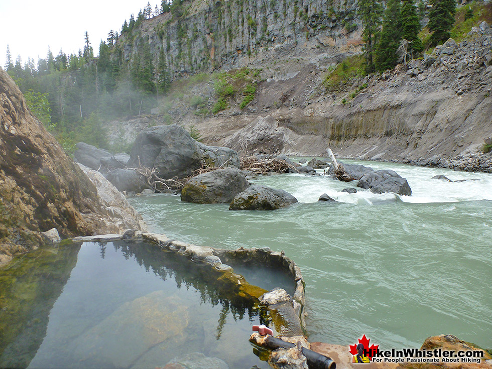
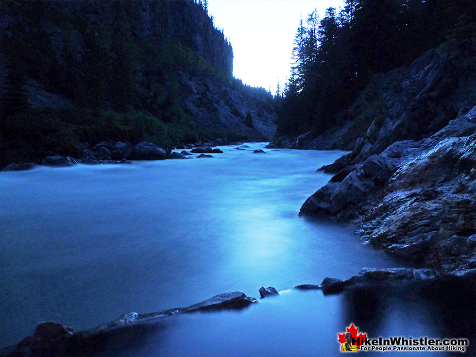
The hot springs at Keyhole flow out of the ground adjacent to the swirling, crashing and wonderfully glacier coloured water of the Lillooet River. The colour varies with the season, but for the most part it is a wonderful, deep, milky turquoise. When the sunlight penetrates the deep valley, the milky turquoise changes to an unnaturally bizarre, emerald green colour as it swirls all around you. Sitting in the springs you look across to the vertical rock face and the massive, truck sized chunks of it that lay in the river next to you. The Lillooet is fed from various glaciers and snowy mountains visible all the way to Pemberton. At the Lillooet River crossing in Pemberton Meadows take a look in the distance and you will make out the spectacularly jagged and violent looking peak of Mount Meager. It is also a good place to reflect on the fact that Mount Meager produced the larges volcanic eruption in Canada, in the last ten thousand years. It occurred about 2400 years ago and Keyhole and Meager Hot Springs are symptoms of current volcanic activity and another major eruption is possible. For such a remote place, Keyhole Hot Springs have a pretty elaborate hot springs layout as well as a very large(unmaintained) camping area in the deep forest, high above the hot springs about a 10 minute walk away. Signs of semi-permanent tarp dwellings can be seen in stages of ruin, but overall the campsite area is amazing. With the exception of being dark due to the thick forest and fresh water a steep, 5 minute walk away, it is perched on a wonderful cliff with great views of the river below and cliff and mountains and waterfalls across. If the campsite had a dozen tents within it, you could space them out enough to not see or hear each other fairly easily. In the last couple years BC Ministry of Forests and Recreation Sites and Trails BC have been aggressively blocking public access to both Meager Hot Springs and Keyhole Hot Springs. Currently, in 2023 they have blocked both access roads with gates to the trailheads and are threatening to issue violation tickets. The warning reads: SITE CLOSED: Trail and hot springs are closed from Apr 1 to Nov 15 each year (spring to fall) The Province will be enforcing this closure and will issue violation tickets to anyone caught ignoring the restrictions. They don't appear to have any legitimate reasons for the closures and are clearly making up vague things to justify blocking public access. For example: "The Upper Lillooet provides important habitat for many wildlife species, including the threatened South Chilcotin grizzly bear population, and is a very important wildlife migration corridor for deer, moose, and mountain goats. Mineral licks at the hot springs provide wildlife with year-round nutrients. The hot springs are also home to the vivid dancer damselfly, a species of special concern that is threatened by intensive recreational use. Ad hoc water diversion mechanisms and user created tubs disturb natural features and alter stream flow, negatively impacting the ecosystem. Human activity at the hot springs can displace wildlife from these valuable habitat features."
Beautiful Geology Everywhere
Further down the river, in the opposite direction of the Keyhole Hot Springs is a beautiful and easily hiked stretch of the river, passing waterfalls on both sides of the river as well as some wonderful, potential campsites on sandy and grassy plateaus next to the river(about 15 minutes away). Across from Keyhole Hot Springs and campsite there is a abrupt and massive opposing rock face created from the eruption of Plinth Peak on Mount Meager in 410BCE. Plinth is one of six main summits on Meager, hidden beyond this rock face that looks both impressively huge and wonderfully close. You can actually see trees frozen in time from the last eruption in the face of this cliff. Sticking out, black eroding away with the cliff.


Recreation Sites and Trails BC have closed Keyhole Hot Springs with the reason being: "Keyhole Falls Trail will be closed from April 1st to November 15th yearly. This seasonal closure is in place to support the recovery of the local Grizzly Bear population." The grizzly bear cub pictured here below was spotted with his brother(up the tree already), at the trailhead parking area for Keyhole Hot Springs. The picture was taken while standing next to our vehicle seconds after we arrived(May 2015). We got out of the area very quickly before encountering their mother.


Beautiful Keyhole Falls
If you find Keyhole Hot Springs closed, Keyhole Falls is just a couple kilometres further on the same road. Just continue driving past the Lillooet River Trail. You will see a large, unmarked parking area and hard to find trail just before the km 50(just before the bridge). If you have doubts that you are parking in the right spot, just get out of your vehicle and listen for a moment. The deep rumbling of Keyhole Falls can be faintly heard from where you park. Climb the gravel embankment(don't cross the vehicle bridge) and look for the faint trail, then follow the faint rumbling from the falls as it soon becomes a thundering echo far below. The trail is just a couple hundred metres long from the parking area. The reason you have to be brave to get to Keyhole Falls is because of the colossal war zone you have to drive through to get to it. It is a bit daunting, however, access to the area is still allowed. You just have to be very aware of being considerate to the massive construction vehicles scrambling to get the job done. There are large signs indicated where you cannot go, which makes navigating to the falls more manageable.


Lillooet River Trail to Keyhole Hot Springs
Back at the Lillooet River Trail to Keyhole Hot Springs, you will find a trailhead parking area, a small sign and permanent outhouse. A new sign now marks the start of the route to Keyhole Hot Springs. This new trail is 2 kilometres long and moderately challenging as it skirts the rugged terrain along the Upper Lillooet River. A couple of sections are very steep, and it is easy to stray from the trail. Along the trail there are at least two fantastic and inviting areas along the trail (beside the river) perfect for camping. Closer to Keyhole Hot Springs, the very nice camping area high up, overlooking the river is still as it has always been. Nice, rustic, wild and of course, unmaintained. The new Lillooet River Trail is well marked with flagging tape and tree reflectors as well as the occasional bench to sit on. Just like the old trail, this new trail is often challenging to navigate. Though it is rarely steep, as the old trail mostly is, this one is a zig-zag through a thick forest and occasional scramble through truck sized boulders. The trail, at a moderate pace should take about a half an hour from your car to the springs. If you have any interest in geology, however, the trail may take you hours. The crumbing cliffs reveal an astounding array of recent volcanic activity and you find yourself staring in amazement at the extraordinarily beautiful rocks.
The Keyhole Hot Springs Trail
![]() The new Lillooet River Trail to Keyhole Hot Springs was built in 2014, and though longer than the old trail, is very scenic and only moderately challenging. The old trail was short, however, very steep. The Lillooet River Trail is 2 kilometres to the springs or about 1.5 kilometres to the huge Keyhole Hot Springs camping area. The beautiful new trail begins in quite an unexpectedly wonderful way. From the dusty old logging road parking area, you enter the forest and immediately find yourself in a large forest clearing with massive cedars all around. You feel as though you have instantly left civilization. A large, well loved fire ring sits in the middle of this clearing and you notice that you could fit several tents here if you had to. The area is very flat and inviting. A trailhead sign and small map indicate the where you will be hiking next, and the trail descends through the forest and comes out to the river and a small seating area. The trail then bends back to the forest and climbs up and away from the river, where it continues, for the most part, away from the river. There are a couple of viewpoints along the way indicated by nice, new signs. Well worth seeing. The viewpoint by the river is an excellent place to camp if you like a beautiful and serene riverside setting.
The new Lillooet River Trail to Keyhole Hot Springs was built in 2014, and though longer than the old trail, is very scenic and only moderately challenging. The old trail was short, however, very steep. The Lillooet River Trail is 2 kilometres to the springs or about 1.5 kilometres to the huge Keyhole Hot Springs camping area. The beautiful new trail begins in quite an unexpectedly wonderful way. From the dusty old logging road parking area, you enter the forest and immediately find yourself in a large forest clearing with massive cedars all around. You feel as though you have instantly left civilization. A large, well loved fire ring sits in the middle of this clearing and you notice that you could fit several tents here if you had to. The area is very flat and inviting. A trailhead sign and small map indicate the where you will be hiking next, and the trail descends through the forest and comes out to the river and a small seating area. The trail then bends back to the forest and climbs up and away from the river, where it continues, for the most part, away from the river. There are a couple of viewpoints along the way indicated by nice, new signs. Well worth seeing. The viewpoint by the river is an excellent place to camp if you like a beautiful and serene riverside setting.


Sights Along the Trail
The trail then continues through deep forest and along a frighteningly chaotic boulder field with house sized boulders filling a chasm between cliffs. There is also an amazing little waterfall that tumbles over the cliff about 15 metres up and looks like a giant shower. Further along the trail you come to the nicely constructed bridge over the one rushing river along the trail. If you ever parked at the old trailhead, this is the river you drove through just before parking. The aptly named(when you had to drive through it back in the day), "Truckwash Creek" is a massive torrent of water plowing through the valley. About 5 minutes past this bridge you come to the Keyhole Hot Springs campsite. The area is entirely unmaintained and aside from an elaborate bear hang area to keep your food, there are no amenities such as outhouses, signs, etc.


If you continue through the camping area and walk along the trail keeping the river on your left, you will come to a fallen tree that has been expertly chainsawed into a staircase leading down to the springs. First you come to the sandy area that at first looks unimpressive until you have a good look around. The water pooling in the sandy pools is amazingly hot and suddenly you realize you are in nirvana. A small wooden bench and indiscreet fire-pit sits next to the pool and someone has left a shovel to dig out the pool. The pool is surrounded by a cliff at your back, and huge boulders and the Lillooet River just a few metres away. Continuing along the path through the huge boulders you come to the two fantastic, cemented in pools on the cliff-side dipping into the river. Some weeks the lower pool floods and is too cold, but if you catch it at the right level it is paradise. Once again, you have a short scramble down a tree trunk to get to these pools. But once you are there, you will never want to get out. Keyhole Hot Springs are pretty amazing.
Keyhole Hot Springs(Lillooet River Trail) Map
![]() The Lillooet River Trail is just a moderately challenging, 2 kilometre trek along the Upper Lillooet River to the campsite and hot springs. It is an adventure through the geologic history of the area, with evidence of the last eruption 2400 years ago everywhere you look. There are a couple steep sections along the route as you descend to the river and ascend up the ridge a couple times. Some find it difficult if overburdened with gear. If you just have a reasonable pack, you should have little difficulty.
The Lillooet River Trail is just a moderately challenging, 2 kilometre trek along the Upper Lillooet River to the campsite and hot springs. It is an adventure through the geologic history of the area, with evidence of the last eruption 2400 years ago everywhere you look. There are a couple steep sections along the route as you descend to the river and ascend up the ridge a couple times. Some find it difficult if overburdened with gear. If you just have a reasonable pack, you should have little difficulty.

History of Keyhole Hot Springs
![]() Mount Meager erupted here 2400 years ago and filled the valley with breccia. The trail to Keyhole Hot Springs shows you plenty of examples of breccia, which is larger pieces of angular rock cemented together with small particles or a mineral cement that forms these marvels. You will see baseball sized examples of these, as well as truck sized ones. At times it is hard to focus on your footing as you wind through these chaotic areas of huge boulders with the most extraordinary rocks. The Mount Meager explosion that filled the valley, blocking the Lillooet River. Eventually water erosion cut a channel through the breccia dam, and Keyhole Falls was born. This amazing waterfalls is just a couple kilometres upriver of Keyhole Hot Springs, and you can drive to the short, unmarked trail from the hot springs, in just 10 minutes. Keyhole Hot Springs is sometimes referred to as Pebble Creek Hot Springs, from the name of the small creek that the old trailhead used to begin from. The Mount Meager eruption, and the the massive avalanche deposits resulted from it, are known as the Pebble Creek Formation. Keyhole Falls and Keyhole Hot Springs emerged through the Pebble Creek Formation. In recent years the Pebble Creek Hot Springs name faded in favour of the Keyhole Hot Springs name owing to the proximity and its association with the spectacular Keyhole Falls. Along with the major eruption 2400 years ago, there have been several recorded landslides. Massively destructive landslides and the inevitable debris flows that follow were known to have occurred in 1931, 1947, 1975, 1986 as well as the brutally enormous one in 2010. Four geologists were never found after being killed in the 1975 debris flow.
Mount Meager erupted here 2400 years ago and filled the valley with breccia. The trail to Keyhole Hot Springs shows you plenty of examples of breccia, which is larger pieces of angular rock cemented together with small particles or a mineral cement that forms these marvels. You will see baseball sized examples of these, as well as truck sized ones. At times it is hard to focus on your footing as you wind through these chaotic areas of huge boulders with the most extraordinary rocks. The Mount Meager explosion that filled the valley, blocking the Lillooet River. Eventually water erosion cut a channel through the breccia dam, and Keyhole Falls was born. This amazing waterfalls is just a couple kilometres upriver of Keyhole Hot Springs, and you can drive to the short, unmarked trail from the hot springs, in just 10 minutes. Keyhole Hot Springs is sometimes referred to as Pebble Creek Hot Springs, from the name of the small creek that the old trailhead used to begin from. The Mount Meager eruption, and the the massive avalanche deposits resulted from it, are known as the Pebble Creek Formation. Keyhole Falls and Keyhole Hot Springs emerged through the Pebble Creek Formation. In recent years the Pebble Creek Hot Springs name faded in favour of the Keyhole Hot Springs name owing to the proximity and its association with the spectacular Keyhole Falls. Along with the major eruption 2400 years ago, there have been several recorded landslides. Massively destructive landslides and the inevitable debris flows that follow were known to have occurred in 1931, 1947, 1975, 1986 as well as the brutally enormous one in 2010. Four geologists were never found after being killed in the 1975 debris flow.

Geology of Keyhole Hot Springs
![]() Mount Meager looms high above Keyhole Hot Springs is the surrounding peaks are known collectively as the Mount Meager Complex. The Meager Complex produced the most recent, major volcanic event in Canada in the last 10,000 years. The eruption 2400 years ago spread ash as far as Alberta. More recently, in 2010 a massive debris flow swept down and into the valley causing Pemberton to be evacuated. The eruption 2400 years ago left a huge pumice outcrop 2 kilometres long and 1 kilometre wide. This outcrop has been mined for decades.
Mount Meager looms high above Keyhole Hot Springs is the surrounding peaks are known collectively as the Mount Meager Complex. The Meager Complex produced the most recent, major volcanic event in Canada in the last 10,000 years. The eruption 2400 years ago spread ash as far as Alberta. More recently, in 2010 a massive debris flow swept down and into the valley causing Pemberton to be evacuated. The eruption 2400 years ago left a huge pumice outcrop 2 kilometres long and 1 kilometre wide. This outcrop has been mined for decades.


Camping at Keyhole Hot Springs
![]() There is quite a nice, unmaintained campground on the bluff above(and before) the hot springs. Located just a 5 minute walk from the springs and Upper Lillooet River. Room for at least a dozen tents, well spaced within the forest, on the cliffs overlooking the river. With the Upper Lillooet River just a 2 minute walk away, you have plenty of fresh glacier water to drink. There are no facilities at the campground except a large and elaborate place to keep your food away from bears. A ladder climbs up to a platform with a cooler for putting food in on it. There are a few rustic fire rings at various tent site places as well as one picnic table overlooking the river. No outhouses, so you have to be considerate of others, and not leave anything that others may encounter.
There is quite a nice, unmaintained campground on the bluff above(and before) the hot springs. Located just a 5 minute walk from the springs and Upper Lillooet River. Room for at least a dozen tents, well spaced within the forest, on the cliffs overlooking the river. With the Upper Lillooet River just a 2 minute walk away, you have plenty of fresh glacier water to drink. There are no facilities at the campground except a large and elaborate place to keep your food away from bears. A ladder climbs up to a platform with a cooler for putting food in on it. There are a few rustic fire rings at various tent site places as well as one picnic table overlooking the river. No outhouses, so you have to be considerate of others, and not leave anything that others may encounter.


Getting down to Upper Lillooet River from the Keyhole Hot Springs campsite is easy. A short, steep trail in the opposite direction to the hot springs takes you down to the boulder strewn, though very beautiful route along the river. You can hike along the river for quite a distance and you are actually hiking parallel, though out of site of, the trail you hiked in from to get to the campsite and Keyhole Hot Springs. For a wild and remote feeling campsite, you will stumble upon a few wild and idyllic, gravel areas perfect for a tent along Upper Lillooet River. Few people venture down here and you almost certainly won't be disturbed by anyone.


Facilities at Keyhole Hot Springs
![]()
![]() Lots of excellent water sources can be found on the drive to Keyhole Hot Springs, as well as the hike and at the springs themselves. At the campsite, you can simply walk down to Upper Lillooet River in just a couple minutes to get fresh water. There are few campsite facilities at the campsite as it is not actively maintained. Which is nice to see, as the area is off the radar for most, and not plagued with too many signs or other signs of humanity. An elaborate, though rustic platform to keep food out of the reach of bears can be found in the campground. No outhouses or tent pads can be found near the springs. One picnic table sits on the bluffs next to one campsite overlooking the river. There are plenty of suitable flat spaces to put up a tent in the campsite and it is quite large and spread out in the wild forest overlooking the river.
Lots of excellent water sources can be found on the drive to Keyhole Hot Springs, as well as the hike and at the springs themselves. At the campsite, you can simply walk down to Upper Lillooet River in just a couple minutes to get fresh water. There are few campsite facilities at the campsite as it is not actively maintained. Which is nice to see, as the area is off the radar for most, and not plagued with too many signs or other signs of humanity. An elaborate, though rustic platform to keep food out of the reach of bears can be found in the campground. No outhouses or tent pads can be found near the springs. One picnic table sits on the bluffs next to one campsite overlooking the river. There are plenty of suitable flat spaces to put up a tent in the campsite and it is quite large and spread out in the wild forest overlooking the river.
Parking & Trailhead Directions to Keyhole Hot Springs
![]()
![]()
![]() Driving directions to Keyhole Hot Springs: Zero your odometer at Village Gate Blvd in Whistler Village and drive north on Hwy 99 toward Pemberton. At 32.1km turn left onto Portage Road and toward downtown Pemberton. At 32.9km turn left at the roundabout onto Birch Drive. At 33.1km turn right at the stop sign onto Prospect Street which becomes Pemberton Valley Road at the stop sign at 34.9km. At 55.2km turn right, cross the bridge over Lillooet River and onto Lillooet River FSR. At 100km look for the roadside parking and trailhead for the Lillooet River Trail to Keyhole Hot Springs.
Driving directions to Keyhole Hot Springs: Zero your odometer at Village Gate Blvd in Whistler Village and drive north on Hwy 99 toward Pemberton. At 32.1km turn left onto Portage Road and toward downtown Pemberton. At 32.9km turn left at the roundabout onto Birch Drive. At 33.1km turn right at the stop sign onto Prospect Street which becomes Pemberton Valley Road at the stop sign at 34.9km. At 55.2km turn right, cross the bridge over Lillooet River and onto Lillooet River FSR. At 100km look for the roadside parking and trailhead for the Lillooet River Trail to Keyhole Hot Springs.
Printable Directions Map to Keyhole Hot Springs
You might want to save this map to your phone or print it out for reference. To print: right click on the map below, click "Save Image As...", save it to your desktop and open and print. Closed from Apr 1- Nov 15 due to Grizzly Bears habituated to humans in the area.

You will notice after you cross the bridge at 55.2 kilometres that the Upper Lillooet FSR has kilometre markings posted on the right side of the road starting here. You don't really need to zero your odometer here, as you can just use these road KM markers instead which are used now in the following. Be careful to keep left at 9km (right goes to Gold Bridge via Hurley Pass) At 36k you will see the massive mudslide carnage of 2010 on your left and an amazing place to pull over and look around. It is amazing to think that 2013 was when the plants and trees finally managed to significantly return here.


At km 37 continue straight past the old Meager Hot Springs turn-off on your left, which is now a mound of dirt(sometimes car sized boulders) blocking the road that once was the giant bridge to Meager Hot Springs. Look for the very old sign on your right, "Meager Hot Springs - Closed". Don't forget to stop here and marvel at the surreal road to nowhere. Just past km 42 look for the new parking area on the right(room for about 15 cars). There is a very small "Lillooet River Trail" sign now, but soon there will likely be a much larger sign. The best thing to keep an eye out for is the tell-tale parking area on the right that looks out of place along an endless logging road. Across from the parking area is the obvious trail and small trail sign... and in the forest a nice little trail map sign to indicate where you are going. The trail is less than 2 kilometres to Keyhole Hot Springs, and fairly easy to follow. If you venture out in low light and without a headlight, you will lose the trail easily. This is a very dangerous trail to get lost on as the cliffs on your right are steep, high and crumbling and on the left the river is fast moving and flanked by similarly steep and crumbling slopes.

Driving to Keyhole Hot Springs
![]() As with the other hot springs near Whistler getting to them is half the fun, and with Keyhole Hot Springs this is particularly so. Setting off from Whistler Village and onto the Sea to Sky Highway heading north, you have quite a few potential pit-stops along the way. Five minutes along you come to the obvious pull-out viewpoint at the right side edge of the highway and overlooking Green Lake. This vantage point is great on a cloudy day, but fantastic on a sunny day. A painted mural depicts the mountains laid out in front of you. Wedge Mountain, Blackcomb Mountain and Whistler Mountain dominate the skyline. Green Lake, unnaturally looking emerald green, a result of glacial silt reflecting the light.
As with the other hot springs near Whistler getting to them is half the fun, and with Keyhole Hot Springs this is particularly so. Setting off from Whistler Village and onto the Sea to Sky Highway heading north, you have quite a few potential pit-stops along the way. Five minutes along you come to the obvious pull-out viewpoint at the right side edge of the highway and overlooking Green Lake. This vantage point is great on a cloudy day, but fantastic on a sunny day. A painted mural depicts the mountains laid out in front of you. Wedge Mountain, Blackcomb Mountain and Whistler Mountain dominate the skyline. Green Lake, unnaturally looking emerald green, a result of glacial silt reflecting the light.

Further north, just before Pemberton, you will see Nairn Falls, again on your right. Green River, that flows from Green Lake and through deep and abrupt cliffs at Nairn Falls. The fenced viewing area at the falls is set up high in the middle of the swirling green pools several metres below you. The pot-hole like configuration of the rock pools at Nairn Falls is caused by centuries of sand, gravel and boulders whirling around and around in these pools, wearing them deeper and rounder over the centuries. From the parking lot to the falls is just 1.2 kilometres and always along the scenic Green River. If you don't have the time to see the falls, the viewpoint over Green River from near the parking lot is worth a look. You will also notice that the Sea to Sky Trail passes through here. This 180 kilometre hiking and biking trail runs from Squamish, through Whistler and all the way to D'Arcy, well north of Pemberton.

Pemberton is just 5 minutes north of Nairn Falls and at the traffic lights with the Petro Can on your left and McDonald's across to your right, you need to turn left onto Portage Road. This is your last chance for food, drinks and gas before leaving civilization. There is an excellent Pub/Restaurant immediately on your left, next to the Petro Can gas station. On your first right there is a great coffee shop called Mt Currie Coffee Company. Their drip coffee is garbage but everything else is amazing. Americano coffee, food, pastries, cappuccino all are fantastic, and the place is so inviting and comfortable you want to stay for hours. This also might be your last chance at free wifi. Keep in mind as well that in about 5 kilometres further toward Keyhole that you will no longer get a cell signal. A block or two further down Portage road and you come to a roundabout. Turn left at the roundabout, cross the train tracks. On your left is a cold beer and wine store and a small grocery store. Straight ahead and you come to a T junction and stop sign. If you turn left here you will see a dollar store with cheap, bulk candles(great for hot springs). Up from the dollar store and right at the Police Station and you will come to a government liquor store and a cheaper and wider selection of booze choices than the beer and wine store. Back at the T junction there is also a large grocery store and there you will find the cheapest and widest selection of grocery food and they also have a great deli with lots of prepared sandwiches, pizza, etc. To continue to Keyhole Hot Springs turn right at the T junction and follow the signs for Pemberton Meadows and you are about to leave civilization. Pemberton Meadows Road is a great country road that runs almost constantly within sight of the Lillooet River until you arrive at the hot springs. The road is very straight, paved, wide and very long. For 25 kilometres you drive past dozens of idyllic farms, endless grassy fields and horses and cows everywhere you look. Keep an eye out for the turnoff 25k from Pemberton. This right turn takes you to the start of the Upper Lillooet Forest Service Road. It starts by cutting in between two huge farm fields. The one on the right is often packed with friendly horses that come running if you wave some grass in their direction. On the opposite side of the road you get the first spectacular view of where you are heading. Mount Meager, the jagged, hostile looking, though beautiful snow covered peak. Keyhole Hot Springs lays in the shadow of that monster, still a few dozen kilometres away.


The paved road ends after the bridge that crosses the Lillooet River and the bumpy, dusty, Upper Lillooet Forest Service Road begins, now with the Lillooet River on your left. For the first few kilometres you don't see much through the forest, but soon the the trees open up and you catch your first great views of the Lillooet River. It sits in a massive, once glacier filled valley and surrounded on either side with untouched, snow capped mountains. There are a couple fantastic places to stop and take in the view and here you will notice the first remnants of the massive slide of 2010. In 2010 a catastrophic mud and debris slide let loose from Mount Meager, flinging, it has been estimated, over 48.5 million cubic metres of debris down from Capricorn Glacier at a speed of 30 metres per second. Making it the largest recorded landslide in the history of Canada. It filled the enormous valley you are about to drive into. The debris, two kilometres long and 300 metres wide, blocked the valley, creating a dam and an enormous lake began forming. 1500 residents in and around Pemberton were evacuated as it was feared the dam would burst and water would engulf the town. Fortunately a day later, the dam began to fall apart slowly, releasing the water more like a river than a tidal wave. Extraordinarily, no one was hurt or killed and the emergency response was notably exceptional.


The debris field is still visible today, still grey and eerie looking. The whole valley still looks dead and very little vegetation has returned. Enormous tree trunks lay, twisted in the river and ghostly white and long dead trees still stand at the edges of the valley. Killed by the the flood or the aftermath, they make the place look amazingly surreal. The shape of the valley and possibly the way the two valleys join not far from this area for some reason cause it to be like a wind tunnel most days. The wind blasts through the debris field, yet 200 metres away, next to your car, there is no wind at all. What a great place.


Back on the road, just a few minutes ahead and you come to the old Meager Hot Springs campsite. Definitely worth driving through to appreciate how this little area of trees remain like an island amongst the disaster. Located in just the right spot and just high enough to avoid the path of the debris flow. Some campsites have great views, once again, to the debris field. Further on(back on the Lillooet FSR) you come to the old left turn(KM 37) to where the huge bridge across Upper Lillooet River to access Meager Hot Springs once stood. This is definitely worth a stop for another surreal viewpoint. The dirt road abruptly ends at the river, now years later, and still dead and dying trees stand everywhere.


Meager Hot Springs - Whistler Area Hot Springs
![]() Meager Hot Springs(aka: Meager Creek Hot Springs) is located 93 kilometres northwest of Whistler, was beautifully developed into gorgeous pools, with a caretaker and usage charge. At its height of popularity, Meager Hot Springs had 30,000 yearly visitors. Unfortunately, due to two recent massive landslides it seems unlikely to ever officially reopen. Just a decade ago, in 2009, a nice, expensive access bridge was installed. A few months later it was dramatically obliterated from another slide in 2010. In 2014 the new VOC Harrison Hut Trail was mostly completed, allowing access to Meager Hot Springs once again. Currently this access road is in a bit of a construction zone, so don't be surprised if the road is blocked by a rock slide or road construction. The old access bridge over the Upper Lillooet River which cost nearly a million dollars was wrecked in seconds in 2010. In 2014 a new route was built to Meager Hot Springs by the UBC Varsity Outdoor Club. Continued here...
Meager Hot Springs(aka: Meager Creek Hot Springs) is located 93 kilometres northwest of Whistler, was beautifully developed into gorgeous pools, with a caretaker and usage charge. At its height of popularity, Meager Hot Springs had 30,000 yearly visitors. Unfortunately, due to two recent massive landslides it seems unlikely to ever officially reopen. Just a decade ago, in 2009, a nice, expensive access bridge was installed. A few months later it was dramatically obliterated from another slide in 2010. In 2014 the new VOC Harrison Hut Trail was mostly completed, allowing access to Meager Hot Springs once again. Currently this access road is in a bit of a construction zone, so don't be surprised if the road is blocked by a rock slide or road construction. The old access bridge over the Upper Lillooet River which cost nearly a million dollars was wrecked in seconds in 2010. In 2014 a new route was built to Meager Hot Springs by the UBC Varsity Outdoor Club. Continued here...


Skookumchuck Hot Springs - Whistler Area Hot Springs
![]() Skookumchuck Hot Springs, located two hours north of Whistler, and on the way to Sloquet Hot Springs. The name Skookumchuck means "strong water" in the language of the Chinook people of the Pacific Northwest. The name is associated with the hot springs because of the nearby First Nation community of Skatin, which was once called Skookumchuck. The Skookumchuck Hot Springs were also once known as St. Agnes Well during the days of the Fraser Canyon Gold Rush, but that name has fallen into disuse. They are also known locally by the Skatin name as the T'sek Hot Springs. The hot springs start in a pool which is far to hot to use so there are a network of tubes emanating from this pool to feed a ramshackle array of tubs. There are five tubs, which include one very large one under an A-frame which could hold 10 people and is beautifully comfortable. A smaller one under a half A-frame privacy screen which could hold 8 under the stars. And three more open tubs. Clothing, you will quickly discover, is optional. Continued here...
Skookumchuck Hot Springs, located two hours north of Whistler, and on the way to Sloquet Hot Springs. The name Skookumchuck means "strong water" in the language of the Chinook people of the Pacific Northwest. The name is associated with the hot springs because of the nearby First Nation community of Skatin, which was once called Skookumchuck. The Skookumchuck Hot Springs were also once known as St. Agnes Well during the days of the Fraser Canyon Gold Rush, but that name has fallen into disuse. They are also known locally by the Skatin name as the T'sek Hot Springs. The hot springs start in a pool which is far to hot to use so there are a network of tubes emanating from this pool to feed a ramshackle array of tubs. There are five tubs, which include one very large one under an A-frame which could hold 10 people and is beautifully comfortable. A smaller one under a half A-frame privacy screen which could hold 8 under the stars. And three more open tubs. Clothing, you will quickly discover, is optional. Continued here...


Sloquet Hot Springs - Whistler Area Hot Springs
![]() Sloquet Hot Springs is a wonderfully wild set of shallow, man-made pools fed by a small, all natural, and very hot, waterfall. The pools stretch from the waterfall to the large and crashing Sloquet River. The large, spread out campsite for the hot springs lies a short 5 minute walk from the springs. You have to follow a dark and quickly descending trail toward the crashing river. As you near, you can smell the unusual, but kind of nice hot springs scent, and you see steam rising all around you, some steam rising, bizarrely, out of the grass clearing on the edge of the river. On your left a rising cliff, on your right the crashing river. The path narrows and steepens, leading to a large fallen tree which the trail seems to run to. So huge though as to not worry you walking the length of. Then, there it is. The massive fallen tree flanks it. Nestled between the tree and a cliff, in a large triangular area, with the river forming the third side are the Sloquet Hot Springs. Continued here...
Sloquet Hot Springs is a wonderfully wild set of shallow, man-made pools fed by a small, all natural, and very hot, waterfall. The pools stretch from the waterfall to the large and crashing Sloquet River. The large, spread out campsite for the hot springs lies a short 5 minute walk from the springs. You have to follow a dark and quickly descending trail toward the crashing river. As you near, you can smell the unusual, but kind of nice hot springs scent, and you see steam rising all around you, some steam rising, bizarrely, out of the grass clearing on the edge of the river. On your left a rising cliff, on your right the crashing river. The path narrows and steepens, leading to a large fallen tree which the trail seems to run to. So huge though as to not worry you walking the length of. Then, there it is. The massive fallen tree flanks it. Nestled between the tree and a cliff, in a large triangular area, with the river forming the third side are the Sloquet Hot Springs. Continued here...


Whistler's Best Hiking Trails!
Whistler & Garibaldi Park Best Hiking by Month!


Explore BC Hiking Destinations!

Whistler Hiking Trails

Squamish Hiking Trails

Vancouver Hiking Trails

Clayoquot Hiking Trails
Victoria Hiking Trails

