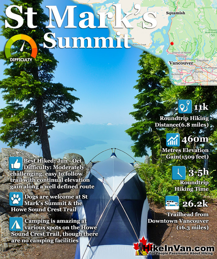
![]() St Mark's Summit is a relatively easy way to get hiking deep into Vancouver's amazing mountains. Starting this hike at Cypress means you drive most of the elevation. Even though you still have another somewhat challenging 460 metres in 5.5 kilometres to hike, the beautiful forest and frequent Howe Sound views make it seem quick and easy.
St Mark's Summit is a relatively easy way to get hiking deep into Vancouver's amazing mountains. Starting this hike at Cypress means you drive most of the elevation. Even though you still have another somewhat challenging 460 metres in 5.5 kilometres to hike, the beautiful forest and frequent Howe Sound views make it seem quick and easy.
 Incredible views of Howe Sound
- Fun, scenic, not too hard trail
- On the Howe Sound Crest Trail!
- Camping is amazing & free!
- Dogs are welcome
- Start at Cypress Resort
- Most find it easier than expected
- Trail continue to The Lions!
- Snowshoe in the winter(difficult)
 Very busy on weekends
Vancouver Hiking Trails
![]() Black Mountain
Black Mountain ![]() Brunswick Mountain
Brunswick Mountain ![]() Burnaby Lake
Burnaby Lake ![]() Burnaby Mountain
Burnaby Mountain ![]() Coliseum Mountain
Coliseum Mountain ![]() Crown Mountain
Crown Mountain ![]() Cypress Falls
Cypress Falls ![]() Deeks Peak
Deeks Peak ![]() Deep Cove
Deep Cove ![]() Deer Lake
Deer Lake ![]() Dog Mountain
Dog Mountain ![]() Goat Mountain
Goat Mountain ![]() Goldie Lake
Goldie Lake ![]() Grouse
Grouse ![]() Hollyburn Mountain
Hollyburn Mountain ![]() Kitsilano Beaches
Kitsilano Beaches ![]() Lighthouse Park
Lighthouse Park ![]() Lynn Canyon
Lynn Canyon ![]() Lynn Peak
Lynn Peak ![]() Mt Elsay
Mt Elsay ![]() Mt Fromme
Mt Fromme ![]() Mt Hanover
Mt Hanover ![]() Mt Harvey
Mt Harvey ![]() Mt Seymour
Mt Seymour ![]() Mt Strachan
Mt Strachan ![]() Mystery Lake
Mystery Lake ![]() Pacific Spirit
Pacific Spirit ![]() Rice Lake
Rice Lake ![]() St Mark's
St Mark's ![]() Stanley Park
Stanley Park ![]() The Lions
The Lions ![]() Unnecessary
Unnecessary
It takes well under two hours for the average hiker to reach St Mark's Summit and the views are fantastic. Not only because of the incredible vantage point over Howe Sound, but the abruptness of St Mark's Summit. The cliffs below you are frighteningly vertical, making the views fantastically majestic. Also the sheer drop off makes Howe Sound and the speck sized boats seem so surreal. The third and possibly the best feature of the St Mark's Summit hike is the intricately huge and varied terrain on the summit. You stand and marvel at one viewpoint, then moments later your friend appears at an extraordinarily improbable, and worryingly dangerous rock outcrop a few dozen metres away. This hilarious game of hide and seek, seemingly can go on forever. As one leads to another, then another. Over and over, the St Mark's Summit reveals one breathtaking vantage point after another, until you are exhausted more with the views than the hike that got you there. When you estimate your hiking time for St Mark's Summit, be sure to include an hour at least at the top. And before you begin your hike back to Cypress, take a moment to glance back at the distant Lions. This incredible trail continues to them and beyond, you've just done 5.5k of the 29k, phenomenal Howe Sound Crest Trail.

St Mark`s Summit is part of the amazing Howe Sound Crest Trail in Cypress Provincial Park and is one of the many beautiful peaks to be climbed if desired on the 29k trail. Among the hiker friendly mountains (in order from Cypress north) on the Howe Sound Crest Trail are: Mount Strachan, St Mark`s Summit, Unnecessary Mountain, The Lions, Mount Harvey, Mount Hanover, Brunswick Mountain and finally Deeks Peak.
St Mark's Summit Tent View

The beautiful Cypress Mountain Resort is the location of the trailhead to the hike to St Mark's Summit. As it is one of among several hikes along the Howe Sound Crest Trail, the trailhead signs and markers don't indicate St Mark's Summit. Instead you have to follow the well laid out and frequent signs that direct you to the Howe Sound Crest Trail and The Lions. The Lions is the well known and highly visible Vancouver mountain on the Howe Sound Crest Trail and sits just beyond St Mark's Summit on the trail. So if you follow the signs for The Lions you will reach the Summit of St Mark's.
The gravel and dirt trail winds through a beautiful and deep forest, occasionally following switchback as the trail ascends further into the mountains. After 20 minutes the trail and forest above and around it noticeably changes to a more wild and natural looking forest. The trail skirts the edge of some steep, though very safe cliffs and your first amazing view of Howe Sound. The intense blue of the ocean far below contrasting with the distant, dark green, tree covered mountains, which then contrast back to the light blue of the sky is breathtaking. So close to Vancouver, yet very little of humanity is visible. No building, no houses, cars or highways in this enormously sweeping view of the British Columbia's coast. Just the occasional, and very distant sailboats silently catching the famous Howe Sound wind shown by the tell-tale white wash trailing behind.

St Mark's Summit is, you suddenly realize is quite large as there are in fact several different and equally beautiful viewpoints to see. Each one has a different perspective on the Howe Sound below. Some views are framed by impossibly huge trees seemingly growing out of the solid rock of the mountain. Other viewpoints have gorgeous clearings where you could sit and enjoy a picnic on the edge of the world or put up a tent with a hard to beat view. There is even a small waterfall barely audible in the background forest that you can reach in just a two minute hike from the summit. The Howe Sound is the view you see in the foreground. As you turn away from the ocean view to the mountains behind you, you see The Lions just a few kilometres away and looking very impressively near. Looking in the direction of The Lions, the Howe Sound Crest Trail disappears down from St Mark's Summit and invitingly north into the distance.
Trailhead Directions to St Mark's Summit
The St Mark's trailhead is very easy to find. It is found at Cypress Mountain Resort in West Vancouver (free parking and free to use the trails). From downtown Vancouver follow the signs across the Lions Gate Bridge as if you were going to Whistler on the Sea to Sky Highway. From Sea to Sky Highway #99 (aka Highway #1), about 10 minutes from the Lions Gate Bridge take the #8 Exit to Cypress Provincial Park. There are clear signs on the highway for this exit so you can't miss it. Follow this road all the way to the end and park at the Cypress Mountain Resort Ski area. Right next to the main, huge Cypress Creek Daylodge, you will see three ski lifts. The one on the left of the three is called the Lions Express. In between the Lions Express lift and the daylodge you will see the well marked trailhead. Be careful as the trailhead signs are a bit confusing. For St Mark's Summit follow the signs for "The Lions". If a sign doesn't show that, then look for the Howe Sound Crest Trail. One or the other will be present along the trail, but don't look for mention of St Mark's Summit on any of them. St Mark's Summit is on the Howe Sound Crest Trail along with several other amazing mountains.
Best Whistler & Garibaldi Park Hiking Trails!
Whistler & Garibaldi Park Hiking by Month!


Explore BC Hiking Destinations!

Whistler Hiking Trails

Squamish Hiking Trails

Vancouver Hiking Trails

Clayoquot Hiking Trails
Victoria Hiking Trails

