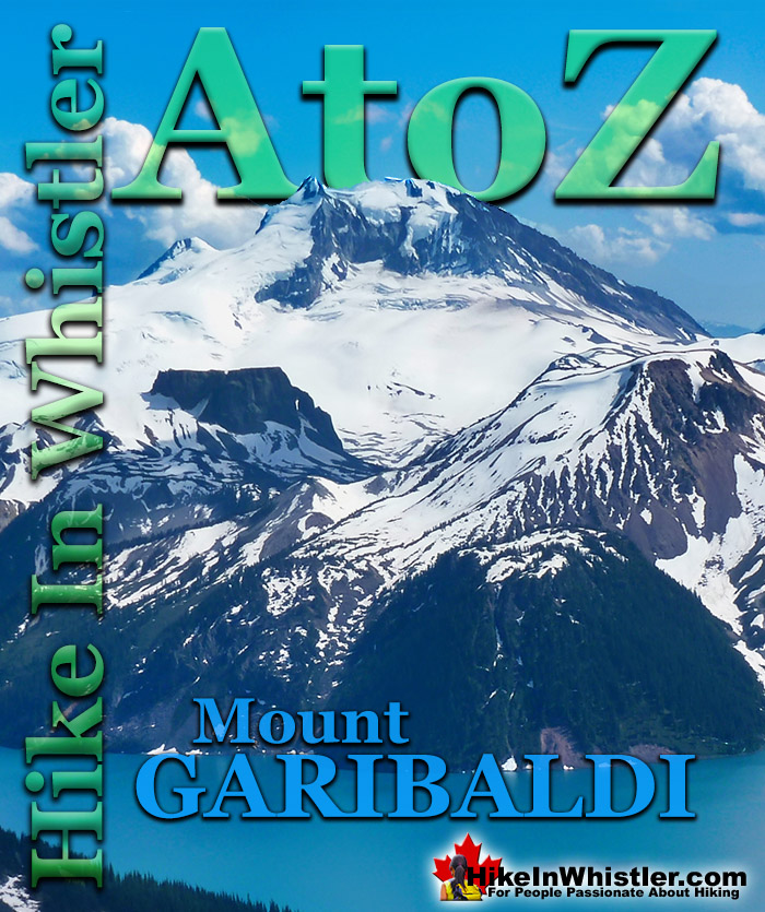
Mount Garibaldi is the huge, potentially active volcano that Garibaldi Provincial Park is named after. Mount Garibaldi also lends its name to the Garibaldi Ranges, the group of mountain ranges that fill Garibaldi Park. A subsection of the Garibaldi Ranges is the Garibaldi Névé, which is the large icefield that stretches out along the east side of Mount Garibaldi.
Whether you are standing in Squamish or high up on Panorama Ridge, Mount Garibaldi towers in the distance. From a wonderful vantage point such as Brandywine Meadows high up in the mountains across the valley, Mount Garibaldi appears monstrously huge. It is easy to imagine it bursting to life as an active volcano, which it technically still is. Named after a 19th century patriot and soldier, Giuseppe Garibaldi, Mount Garibaldi is a massive 2678 metre giant at the southern end of the park. It was named after Garibaldi by Captain George Henry Richards of the Royal Navy in 1860. Guiseppe Garibaldi had gained worldwide acclaim that year by unifying Italy by repatriating Sicily and Naples. In 1907 a group of Vancouver climbers reached the summit of Mount Garibaldi and marvelled at the view. In particular, Garibaldi Lake and Black Tusk caught their interest. Several forays into the area followed and a regular hiking camp was established between Black Tusk and Garibaldi Lake. In 1920 the Garibaldi Park Reserve was established and in 1927 Garibaldi Provincial Park was born.
Mount Garibaldi From Panorama Ridge
Mount Garibaldi, The Table and Mount Price
Garibaldi's Peaks
Garibaldi has two peaks in addition to the highest peak that is referred to as Mount Garibaldi , with an elevation of 2678 metres/8786 feet. The next highest peak is Atwell Peak on the southern edge of the summit plateau, with an elevation of 2655 feet/8711 feet. Atwell Peak is named after Atwell King, who led the first recorded ascent of Mount Garibaldi in 1907. One of the guides in the party, Arthur Tinniswood Dalton, has the third highest peak of Mount Garibaldi named after him. Dalton Dome is located on the west of the main summit and sits at an elevation 2653 metres/8704 feet and can be distinguished by its rounded shape. Other minor summits on Mount Garibaldi include, The Tent at 2465 metres/8087 feet, Diamond Head at 2056 metres/6745 feet, and so named because of its resemblance to Hawaii's Diamond Head.
Mount Garibaldi From Alice Lake
Mount Garibaldi From Black Tusk
Mount Garibaldi From Brandywine Meadows
More Whistler & Garibaldi Park Hiking A to Z!
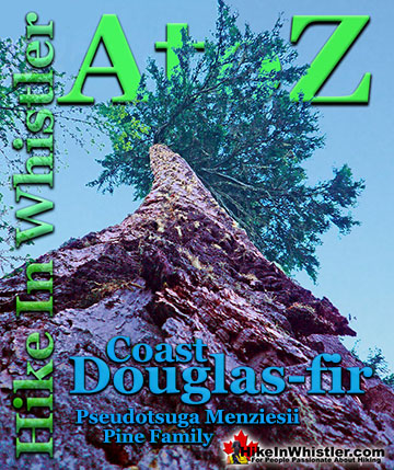
Coast Douglas-fir trees are medium to extremely large trees that you will encounter in Whistler and Garibaldi Park. They are the second tallest conifer ...
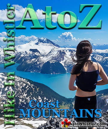
The Coast Mountains run from the Yukon down to Vancouver along the west coast of British Columbia in a band that averages 300 kilometres wide(190 miles). ...
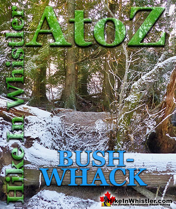
Bushwhack is a term often used in Canada and the United States to refer to hiking off-trail where no trail exists. Literally means 'bush' and 'whack'. To ...
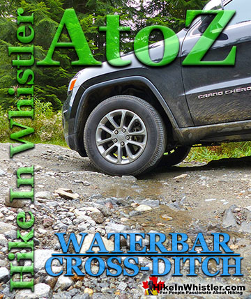
Waterbar and Cross-Ditch: the purpose of a waterbar or cross-ditch is to capture and redirect surface water from the road and channel it across the road ...
Tom Fyles (27 June 1887 - 27 March 1979) was an astoundingly skilled climber and mountaineer based out of Vancouver where he was an early explorer of the ...
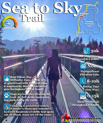
The Sea to Sky Trail is a 180 kilometre multi-use trail that runs from Squamish to D'Arcy. The trail is still under construction in many parts, however, the amazing route through Whistler is finally in ...
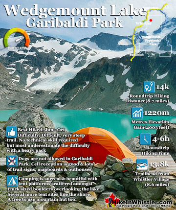
Wedgemount Lake itself is a magnificent destination for a day hike or spectacular overnight beneath the dazzling mountain peaks and stars above Garibaldi Provincial Park. Many sleep under the stars on one of ...
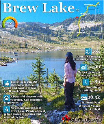
Brew Lake is beautiful mountain lake just a short drive south of Whistler and is relatively unknown and seldom hiked. Laying at the base of Mount Brew, Brew Lake lays in a massive alpine valley of enormous ...
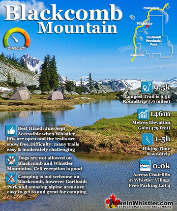
Blackcomb Mountain holds an impressive and ever growing array of hiking trails. From the moment you arrive at the Rendezvous Lodge, you see hiking trails ascend into the distance. The Rendezvous Lodge is ...
July is a wonderful time to hike in Whistler and Garibaldi Provincial Park. The weather is beautiful and the snow on high elevation hiking trails is long ...
August hiking in Whistler definitely has the most consistently great, hot weather. You can feel the rare pleasure of walking across a glacier shirtless and ...
September hiking in Whistler is possibly the best month of all. The snow has melted far up to the mountain tops, yet the temperatures are still quite ...
Hiking in Whistler in October is often unexpectedly stunning. The days are much shorter and colder but the mountains are alive with colour from the fall ...
Hiking in Whistler is spectacular and wonderfully varied. Looking at a map of Whistler you see an extraordinary spider web of hiking trails that are unbelievably numerous. Easy trails, moderate trails and challenging hiking trails are all available. Another marvellous ...
Squamish is located in the midst of a staggering array of amazing hiking trails. Garibaldi Provincial Park sprawls alongside Squamish and up and beyond Whistler. Tantalus Provincial Park lays across the valley to the west and the wonderfully remote Callaghan Valley ...
Vancouver is surrounded by seemingly endless hiking trails and mountains to explore. Massive parks line up one after another. Mount Seymour Provincial Park, Lynn Canyon Park, Grouse Mountain, Cypress Park and the enormous Garibaldi Park all contribute to Vancouver ...
Clayoquot Sound has a staggering array of hiking trails within it. Between Tofino and Ucluelet, Pacific Rim Park has several wilderness and beach trails, each one radically different from the last. The islands in the area are often Provincial parks on their own with ...
Victoria has a seemingly endless number of amazing hiking trails. Most take you to wild and beautiful Pacific Ocean views and others take you to tranquil lakes in beautiful BC Coastal Rainforest wilderness. Regional Parks and Provincial Parks are everywhere you turn ...
The West Coast Trail was created after decades of brutal and costly shipwrecks occurred along the West Coast of Vancouver Island. One shipwreck in particular was so horrific, tragic and unbelievable that it forced the creation of a trail along the coast, which ...