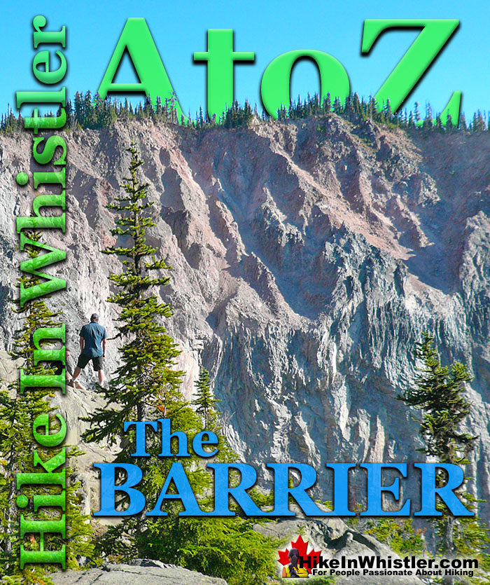
![]() The Barrier formed as a result of huge lava flows from Clinker Peak on the west shoulder of Mount Price during the last ice age. About thirteen thousand years ago, the Cheakamus River valley was filled by an enormous glacier, part of the Cordilleran Ice Sheet. Lava flowed from Clinker Peak and pressed up against the massive glacier. The lava ponded and formed what geologists call an ice-marginal lava flow.
The Barrier formed as a result of huge lava flows from Clinker Peak on the west shoulder of Mount Price during the last ice age. About thirteen thousand years ago, the Cheakamus River valley was filled by an enormous glacier, part of the Cordilleran Ice Sheet. Lava flowed from Clinker Peak and pressed up against the massive glacier. The lava ponded and formed what geologists call an ice-marginal lava flow.
Whistler & Garibaldi Hiking
![]() Alexander Falls
Alexander Falls ![]() Ancient Cedars
Ancient Cedars ![]() Black Tusk
Black Tusk ![]() Blackcomb Mountain
Blackcomb Mountain ![]() Brandywine Falls
Brandywine Falls ![]() Brandywine Meadows
Brandywine Meadows ![]() Brew Lake
Brew Lake ![]() Callaghan Lake
Callaghan Lake ![]() Cheakamus Lake
Cheakamus Lake ![]() Cheakamus River
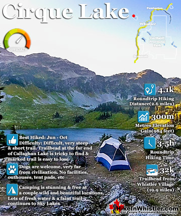
Cheakamus River ![]() Cirque Lake
Cirque Lake ![]() Flank Trail
Flank Trail ![]() Garibaldi Lake
Garibaldi Lake ![]() Garibaldi Park
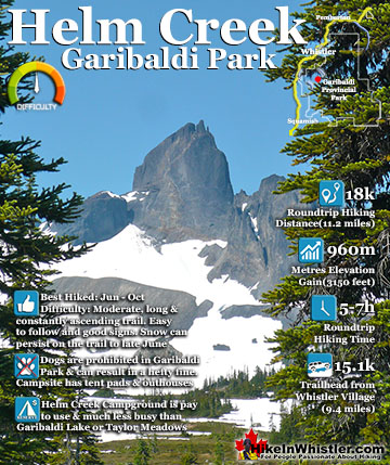
Garibaldi Park ![]() Helm Creek
Helm Creek ![]() Jane Lakes
Jane Lakes ![]() Joffre Lakes
Joffre Lakes ![]() Keyhole Hot Springs
Keyhole Hot Springs ![]() Logger’s Lake
Logger’s Lake ![]() Madeley Lake
Madeley Lake ![]() Meager Hot Springs
Meager Hot Springs ![]() Nairn Falls
Nairn Falls ![]() Newt Lake
Newt Lake ![]() Panorama Ridge
Panorama Ridge ![]() Parkhurst Ghost Town
Parkhurst Ghost Town ![]() Rainbow Falls
Rainbow Falls ![]() Rainbow Lake
Rainbow Lake ![]() Ring Lake
Ring Lake ![]() Russet Lake
Russet Lake ![]() Sea to Sky Trail
Sea to Sky Trail ![]() Skookumchuck Hot Springs
Skookumchuck Hot Springs ![]() Sloquet Hot Springs
Sloquet Hot Springs ![]() Sproatt East
Sproatt East ![]() Sproatt West
Sproatt West ![]() Taylor Meadows
Taylor Meadows ![]() Train Wreck
Train Wreck ![]() Wedgemount Lake
Wedgemount Lake ![]() Whistler Mountain
Whistler Mountain
![]() January
January ![]() February
February ![]() March
March ![]() April
April ![]() May
May ![]() June
June ![]() July
July ![]() August
August ![]() September
September ![]() October
October ![]() November
November ![]() December
December
An ice-marginal lava flow is interesting because it causes the lava flow that pools against the glacier to cool relatively quickly forming a solid, rock barrier. Behind this barrier of rock, a lava pool forms. As the glacier retreats as it did after the last ice age, this barrier remains and is characterized as large, steep and unstable. The Barrier was formed in this way from this massive lava flow from Clinker Peak. The lava flow has been studied in detail and four “lobes” have been identified. The First Lobe, closest to Clinker Peak pushes into Garibaldi Lake separating Price Bay from the Garibaldi Lake campground. The Second Lobe covers the area separating Garibaldi Lake from Lesser Garibaldi Lake and is the lobe that created Garibaldi Lake. The Third Lobe formed The Barrier and created Lesser Garibaldi Lake. The Fourth Lobe extends from The Barrier and can be seen today as the very abrupt cliffs along the opposite side of the Rubble Creek valley.
In the spring of 1856 more than 25 million cubic metres of rock from The Barrier crashed down the valley of what is today called Rubble Creek. The incredible torrent of volcanic rock boulders crashed down the valley more than 6 kilometres at a speed of more than 30 metres per second. The vertical distance of the debris flow was over 1000 metres measured from the top of The Barrier to the end of the debris field where Rubble Creek meets Cheakamus River.


The exact cause of the 1856 Rubble Creek landslide is difficult to know for sure. There are a couple of likely possibilities geologists have come up with. Water from Garibaldi Lake ends up passing through The Barrier via a subsurface drainage system that comes out the other side as springs far below. Groundwater pressure may have increased due to some sort of blockage resulting in pressures that triggered the slide. Another theory is that an earthquake could have ruptured The Barrier, causing the massive release of rock down the valley. There is a record of an earthquake in the area in 1853, however no record of an earthquake in the years that follow, before or after the 1856 Rubble Creek slide. It is difficult to confirm that an earthquake did not occur in 1856 owing to the distance to populated areas at the time. The abrupt shape of The Barrier and its interesting origin not only explain how it formed into such and unusual way, but why it will continue to threaten another collapse.


The Barrier is easy to see at a few good vantage points. You can see it, though not terribly impressively from the Rubble Creek trailhead to Garibaldi Provincial Park. The best way to see it on foot is from the wonderful Barrier viewpoint along the trail to Garibaldi Lake. About 30 minutes before you get to the Garibaldi Lake campground on the Rubble Creek trail you will see the very short side trail to The Barrier viewpoint. It is located almost directly across from the ominously gigantic wall that looks to be crumbling before your eyes. Quite a sight to behold, and the viewpoint is quite nice with its large boulders to take a seat on and robust trees clinging to life on the edge of the enormous chasm The Barrier will once again collapse into.


More Whistler & Garibaldi Park Hiking A to Z!

The Best Whistler & Garibaldi Park Hiking Trails!
Whistler & Garibaldi Park Best Hiking by Month!


Explore BC Hiking Destinations!

Whistler Hiking Trails

Squamish Hiking Trails

Vancouver Hiking Trails

Clayoquot Hiking Trails
Victoria Hiking Trails

