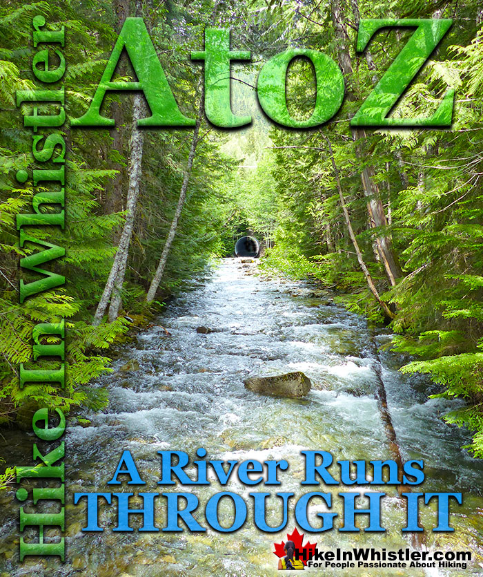
![]() Twentyone Mile Creek begins its long and steep journey from Rainbow Lake, high up and between Mount Sproatt and Rainbow Mountain. Cutting between the two mountains, Twentyone Mile Creek flattens out somewhat, passes under Alta Lake Road, then winds its way through a deep and dark forest before flowing into the River of Golden Dreams near the end of Lorimer Road. This hidden forest extends from Rainbow Park to Emerald Forest and between Alta Lake Road and the River of Golden Dreams.
Twentyone Mile Creek begins its long and steep journey from Rainbow Lake, high up and between Mount Sproatt and Rainbow Mountain. Cutting between the two mountains, Twentyone Mile Creek flattens out somewhat, passes under Alta Lake Road, then winds its way through a deep and dark forest before flowing into the River of Golden Dreams near the end of Lorimer Road. This hidden forest extends from Rainbow Park to Emerald Forest and between Alta Lake Road and the River of Golden Dreams.
Whistler & Garibaldi Hiking
![]() Alexander Falls
Alexander Falls ![]() Ancient Cedars
Ancient Cedars ![]() Black Tusk
Black Tusk ![]() Blackcomb Mountain
Blackcomb Mountain ![]() Brandywine Falls
Brandywine Falls ![]() Brandywine Meadows
Brandywine Meadows ![]() Brew Lake
Brew Lake ![]() Callaghan Lake
Callaghan Lake ![]() Cheakamus Lake
Cheakamus Lake ![]() Cheakamus River
Cheakamus River ![]() Cirque Lake
Cirque Lake ![]() Flank Trail
Flank Trail ![]() Garibaldi Lake
Garibaldi Lake ![]() Garibaldi Park
Garibaldi Park ![]() Helm Creek
Helm Creek ![]() Jane Lakes
Jane Lakes ![]() Joffre Lakes
Joffre Lakes ![]() Keyhole Hot Springs
Keyhole Hot Springs ![]() Logger’s Lake
Logger’s Lake ![]() Madeley Lake
Madeley Lake ![]() Meager Hot Springs
Meager Hot Springs ![]() Nairn Falls
Nairn Falls ![]() Newt Lake
Newt Lake ![]() Panorama Ridge
Panorama Ridge ![]() Parkhurst Ghost Town
Parkhurst Ghost Town ![]() Rainbow Falls
Rainbow Falls ![]() Rainbow Lake
Rainbow Lake ![]() Ring Lake
Ring Lake ![]() Russet Lake
Russet Lake ![]() Sea to Sky Trail
Sea to Sky Trail ![]() Skookumchuck Hot Springs
Skookumchuck Hot Springs ![]() Sloquet Hot Springs
Sloquet Hot Springs ![]() Sproatt East
Sproatt East ![]() Sproatt West
Sproatt West ![]() Taylor Meadows
Taylor Meadows ![]() Train Wreck
Train Wreck ![]() Wedgemount Lake
Wedgemount Lake ![]() Whistler Mountain
Whistler Mountain
![]() January
January ![]() February
February ![]() March
March ![]() April
April ![]() May
May ![]() June
June ![]() July
July ![]() August
August ![]() September
September ![]() October
October ![]() November
November ![]() December
December
If you look closely at one of the parking lots in Rainbow Park, you will see a small trail sign for the wonderful trail that takes you through this secluded forest, all the way to Emerald Forest. A River Runs Through It is an insanely winding trail that follows a dizzying route through this captivating forest with Twentyone Mile Creek running through it. A popular, though brutally challenging bike trail, A River Runs Through It has numerous, elaborate ramps, small bridges, and one large bridge that spans Twentyone Mile Creek. A River Runs Through It has a couple shortcut trails that cut a couple kilometres off of it to make it a more manageable and enjoyable hiking trail. If you add in another two connecting trails, you can turn A River Runs Through It into a beautiful 6 kilometre circle route. You can start this circle route from a couple spots on Alta Lake Road, or at Rainbow Park, or at the end of Lorimer Road. The end of Lorimer Road starting point has the advantage of being very close to Whistler Village. You can drive to this starting point from Whistler Village in 3 minutes, or bike there in 8 minutes, or walk there in 22 minutes. From the end of Lorimer Road you get on the Valley Trail, cross the bridge over the River of Golden Dreams, then cross the train tracks and enter Emerald Forest on your left. Climbing up the trail that skirts the gravel pit leads you to the top of the gravel pit and you then enter the deep, dark, emerald coloured forest.
Emerald Forest To A River Runs Through It

Emerald Forest to A River Runs Through It
This trail takes you 1.4 kilometres through Emerald Forest before bearing left and descending down to the old access road. Directly across this road is the start of A River Runs Through It North. If you don't see it, you may have come out of Emerald Forest too early and just need to follow the old road to the right and you will spot the sign for A River Runs Through It on your left. If you come out to Alta Lake Road, you have gone too far. The trail quickly descends into the wonderfully dark and wild forest. One kilometre in you come to your first shortcut by connecting onto Bart's Dark Trail. This 0.8 kilometre section cuts out a much longer and windier section of A River Runs Through It. Bart's Dark Trail leads to the narrow bridge across Twentyone Mile Creek.
Twentyone Mile Creek Passes Under Alta Lake Road

A River Runs Through It Bridge Over Twentyone Mile Creek

Twentyone Mile Creek at Alta Lake Road

Old Deadfall Across Twentyone Mile Creek

A River Runs Through It Map
From here A River Runs Through It continues its wildly meandering course through the forest. This is a nice 2.4 kilometre walk in the woods that takes you through this very scenic forest to a bunch of nice creek views. If you prefer to take another shortcut, you will see, just after the bridge crossing, the Rainbow Express trail cut through the forest in a fairly direct 300 metre route to reconnect to A River Runs Through It South. This last section of A River Runs Through It is just 0.8 kilometres long and emerges at Rainbow Park. Rainbow Park is one of Whistler's countless gorgeous lakeside parks and here you will find washrooms, a sandy beach, a huge wharf, and one of Whistler's best views of Wedge, Blackcomb and Whistler mountains. The Valley Trail disappears into the forest along Alta Lake and emerges at Lorimer Road in just 1.5 kilometres, completing the 6 kilometre circle route.

More Whistler & Garibaldi Park Hiking A to Z!

The Best Whistler & Garibaldi Park Hiking Trails!
Whistler & Garibaldi Park Best Hiking by Month!


Explore BC Hiking Destinations!

Whistler Hiking Trails

Squamish Hiking Trails

Vancouver Hiking Trails

Clayoquot Hiking Trails
Victoria Hiking Trails

