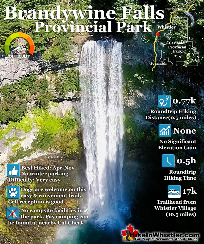
![]() Brandywine Falls is one of the must see sights on the drive to or from Whistler, and arguably the nicest of Whistler’s numerous beautiful waterfalls. Located about halfway between Squamish and Whistler, the falls drop from a 70 metre/230 foot, unnaturally abrupt looking cliff to the valley below. Brandywine Falls Provincial Park is such a popular, accessible and beautiful sight that it has a large and elaborate viewing platform directly opposite the falls.
Brandywine Falls is one of the must see sights on the drive to or from Whistler, and arguably the nicest of Whistler’s numerous beautiful waterfalls. Located about halfway between Squamish and Whistler, the falls drop from a 70 metre/230 foot, unnaturally abrupt looking cliff to the valley below. Brandywine Falls Provincial Park is such a popular, accessible and beautiful sight that it has a large and elaborate viewing platform directly opposite the falls.

 Viewing platforms with great views
- Free parking off the Sea to Sky Highway
- Sea to Sky Trail here continues to Whistler Village
- Swim Lake is just 5 minutes away
- Whistler Bungee Bridge is not far
- Winter parking at Bungee Bridge
- Dog friendly & bike friendly
- Beautiful to see year-round
 Parking lot gated in winter
- Gets very crowded in the summer
Whistler & Garibaldi Hiking
![]() Alexander Falls
Alexander Falls ![]() Ancient Cedars
Ancient Cedars ![]() Black Tusk
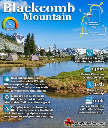
Black Tusk ![]() Blackcomb Mountain
Blackcomb Mountain ![]() Brandywine Falls
Brandywine Falls ![]() Brandywine Meadows
Brandywine Meadows ![]() Brew Lake
Brew Lake ![]() Callaghan Lake
Callaghan Lake ![]() Cheakamus Lake
Cheakamus Lake ![]() Cheakamus River
Cheakamus River ![]() Cirque Lake
Cirque Lake ![]() Flank Trail
Flank Trail ![]() Garibaldi Lake
Garibaldi Lake ![]() Garibaldi Park
Garibaldi Park ![]() Helm Creek
Helm Creek ![]() Jane Lakes
Jane Lakes ![]() Joffre Lakes
Joffre Lakes ![]() Keyhole Hot Springs
Keyhole Hot Springs ![]() Logger’s Lake
Logger’s Lake ![]() Madeley Lake
Madeley Lake ![]() Meager Hot Springs
Meager Hot Springs ![]() Nairn Falls
Nairn Falls ![]() Newt Lake
Newt Lake ![]() Panorama Ridge
Panorama Ridge ![]() Parkhurst Ghost Town
Parkhurst Ghost Town ![]() Rainbow Falls
Rainbow Falls ![]() Rainbow Lake
Rainbow Lake ![]() Ring Lake
Ring Lake ![]() Russet Lake
Russet Lake ![]() Sea to Sky Trail
Sea to Sky Trail ![]() Skookumchuck Hot Springs
Skookumchuck Hot Springs ![]() Sloquet Hot Springs
Sloquet Hot Springs ![]() Sproatt East
Sproatt East ![]() Sproatt West
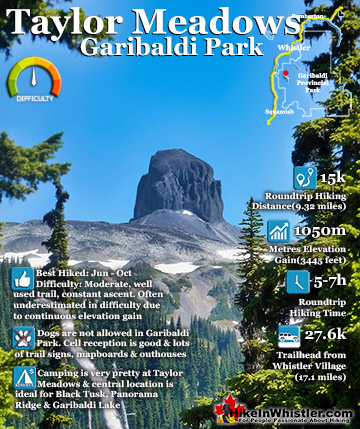
Sproatt West ![]() Taylor Meadows
Taylor Meadows ![]() Train Wreck
Train Wreck ![]() Wedgemount Lake
Wedgemount Lake ![]() Whistler Mountain
Whistler Mountain
![]() January
January ![]() February
February ![]() March
March ![]() April
April ![]() May
May ![]() June
June ![]() July
July ![]() August
August ![]() September
September ![]() October
October ![]() November
November ![]() December
December
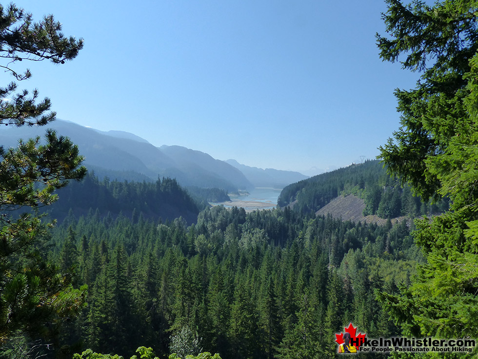
The trailhead parking is just off of the Sea to Sky Highway and the short, 5 minute trail to the viewpoint is smooth, flat and easy. If you continue along the trail past the viewing platform you will quickly arrive at another gorgeous viewpoint. Daisy Lake stretches out in the distance from the viewing area perched high above the valley far below. Most visitors to Brandywine Falls only see the two viewpoint areas, however the park has a couple other short trails to lakes as well as the Sea to Sky Trail which continues to Whistler and beyond. The Swim Lake trail is a short, ten minute hike through the forest to a small lake engulfed in deep forest. The 1.2 kilometre trail to Lava Lake starts at the covered bridge in the opposite direction to the trail to Brandywine Falls. Swim Lake and Lava Lake are nice to see, but certainly disappointing compared to Brandywine Falls. For an impressive sight to see comparable to Brandywine Falls, you can hike along the Sea to Sky Trail for 30 minutes to the Whistler Bungee Bridge. Spanning high above Cheakamus River, the Whistler Bungee Bridge gives you breathtaking views of the huge chasm below.

Unmarked Route to the Base of the Falls
Along with the marked trails in Brandywine Falls Provincial Park there is a lesser known and unmarked route to the base of the falls that is quite an adventure. Found by hopping the fence at the Daisy Lake viewpoint and following the cliff until it slopes down into the valley below. This 30 minute route is steep and treacherous, but manageable by most hikers as long as you are comfortable with climbing down a steep section with a knotted rope. There are not a lot of facilities at the park as it is a day use only park. The huge, deluxe parking lot has outhouses and picnic tables as well as parking to accommodate large RV’s, though not overnight. There are no parking fees or entrance charges for Brandywine Falls Provincial Park.


Guides to the Best of Whistler
 Best Dog Friendly Hiking Trails
Whistler is very dog friendly and the number of wonderful hiking trails that your dog will love is huge. The massively varied hiking trails range from easy, short, close to Whistler Village to challenging, long and deep in the endless wilderness around Whistler. You can find dog friendly trails in and around Whistler Village that take you through deep, dark and magical forests. Or you can drive beyond Whistler Village and take your dog to spectacular alpine lakes. Some requiring little or no hiking, while others are found after hiking challenging and long trails. Many of these places are comparatively quiet and often you and your dog will have the the wilderness to yourselves. In and around Whistler Village you have Lost Lake with its spider web of trails... Continued here.
 Best Free Whistler Camping
Whistler is surrounded by an immense wilderness dotted with spectacular, hidden lakes and amazing places to set up a tent. Decades of logging activity has left a network of forest service roads that has opened easy access to these places. Some of these you can drive to and some you may need a 4x4 to comfortably get to. Some places to camp for free you can drive to, some require a short hike and others are fairly long hikes to reach. Beautiful Callaghan Valley is home to several incredible and free places to camp. Callaghan Lake has a great free drive-to campsite just steps from this spectacular alpine lake. If you have a canoe, you can paddle to the end of Callaghan Lake and hike the short, but steep trail up to Cirque Lake. This gorgeous lake is deep in the alpine wilderness... Continued here.
 No Car? No Problem! Whistler Trails
Whistler as a resort has a wonderful car-free core. The Village Stroll runs through the heart of Whistler Village and is entirely car free. If you are visiting Whistler or living here and you don't have a car, it's no problem. On foot or on a bike you can travel the extensive network of non-motorized trails. The Valley Trail snakes through Whistler Village and extends in several directions, all of which lead to beautiful parts of Whistler. The Sea to Sky Trail and the Lost Lake trails continue this massive, car-free network of trails running almost everywhere in Whistler. When it comes to many of the best hiking trails, getting to the trailheads on foot, by bike or public transit can be tricky at best or complicated and impractical at worst. Many trailheads are far from Whistler Village and... Continued here.
 Kid Friendly Whistler Hiking Trails
There are plenty of excellent, kid and family friendly hiking trails and destinations in and around Whistler. Kid and family friendly generally means an easy and somewhat short trail that a toddler can happily manage. Some of these trails are flat enough to be stroller friendly, such as Brandywine Falls, Whistler Mountain and Blackcomb Mountain. Others such as Logger’s Lake, Cheakamus River and Madeley Lake have short enough trails to reach them that you can manage with little kids that don't want to hike too far. Some of these hikes and walks are popular and close to Whistler Village, like Whistler Mountain, Blackcomb Mountain, Lost Lake Park, Rainbow Park and Meadow Park. Others are a beautiful, but far drive into the mountains and tricky to find... Continued here.
Brandywine Falls Provincial Park
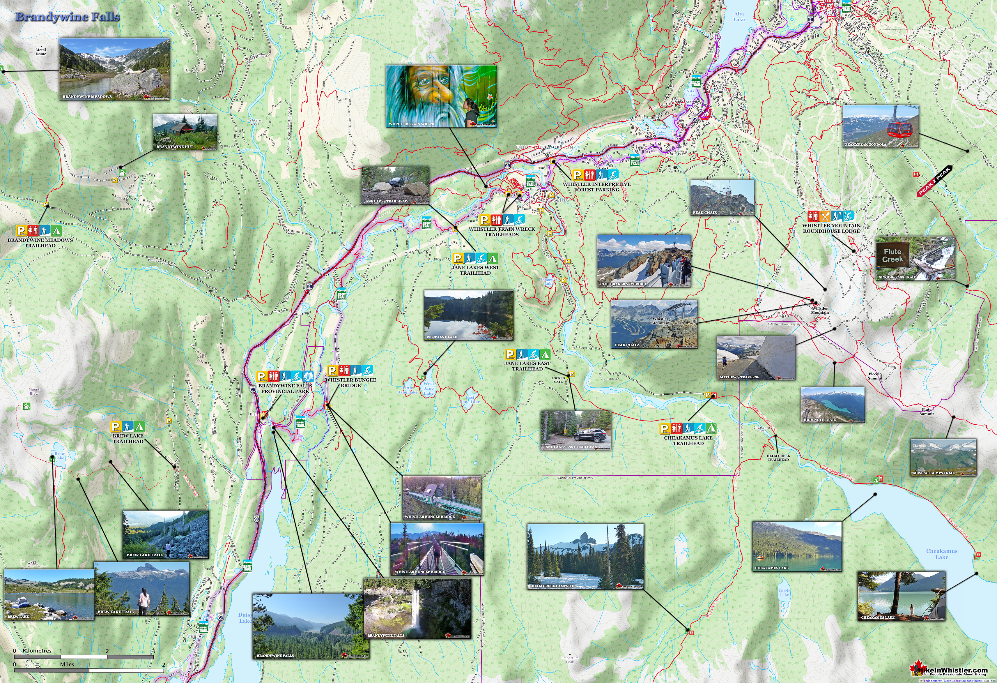
Brandywine Falls Map
![]() Brandywine Falls has the Sea to Sky Trail run directly through it, allowing for quite a bit of further hiking and biking. The Whistler Bungee Bridge is a great, short hike from the falls. Alternatively, you could drive directly to the Bungee Bridge by heading north on the Sea to Sky Highway, towards Whistler and turn right at the big sign for Whistler Bungee on Cal-Cheak Forest Service Road. Follow the potholed, gravel road for a couple kilometres to the parking area for the Whistler Bungee Bridge. Unlike Brandywine Falls Provincial Park, which is gated 11pm to 7am daily in the summer, and gated all winter, Whistler Bungee Bridge is accessible anytime, year-round unless heavy snow has buried the road.
Brandywine Falls has the Sea to Sky Trail run directly through it, allowing for quite a bit of further hiking and biking. The Whistler Bungee Bridge is a great, short hike from the falls. Alternatively, you could drive directly to the Bungee Bridge by heading north on the Sea to Sky Highway, towards Whistler and turn right at the big sign for Whistler Bungee on Cal-Cheak Forest Service Road. Follow the potholed, gravel road for a couple kilometres to the parking area for the Whistler Bungee Bridge. Unlike Brandywine Falls Provincial Park, which is gated 11pm to 7am daily in the summer, and gated all winter, Whistler Bungee Bridge is accessible anytime, year-round unless heavy snow has buried the road.

The Brandywine Falls Trail
![]() Just steps from your car you will come to a nice picnic area just before the covered bridge over Brandywine Creek. There are some nice information boards and maps about the area. Crossing the bridge brings you to a T junction. Left is the start of the Lava Lake trail and right is the Brandywine Falls trail. Both trails are wide and flat gravel trails, smooth enough to roll a baby stroller on. The trail runs alongside Brandywine Creek for about 300 metres before veering away at a train tracks crossing then arriving at the beautiful viewing platform across from Brandywine Falls. From your car to this viewpoint is only about 5-10 minutes of leisurely walking.
Just steps from your car you will come to a nice picnic area just before the covered bridge over Brandywine Creek. There are some nice information boards and maps about the area. Crossing the bridge brings you to a T junction. Left is the start of the Lava Lake trail and right is the Brandywine Falls trail. Both trails are wide and flat gravel trails, smooth enough to roll a baby stroller on. The trail runs alongside Brandywine Creek for about 300 metres before veering away at a train tracks crossing then arriving at the beautiful viewing platform across from Brandywine Falls. From your car to this viewpoint is only about 5-10 minutes of leisurely walking.


Brandywine Falls Viewing Platforms
The trail continues past the viewing platform to a trail side view of the falls, then to the second viewing area just a minute or two further. This is the very nice, and much quieter viewpoint of the huge valley and distant Daisy Lake. Looking down you see Brandywine Creek meander through the forest and merge with Cheakamus River before meeting Daisy Lake. Higher up, in the distance, Black Tusk is clearly visible. An information board depicts the remarkable formation of Black Tusk and describes some of the geology in the area. It has a wonderful picture of Black Tusk as you see it now, with a dotted line over it, representing the original size and shape of it before it crumbled away to its current form.


Base of the Falls Trail
![]() At the Daisy Lake viewpoint, if you look to your left you will see a faint path begin on the other side of the fence. This is the unmarked route to the base of Brandywine Falls. It starts by following the edge of the cliff through the forest for a few hundred metres before the cliff flattens out to a large rocky slope that takes you down into the valley. There is a sketchy, knotted rope section which makes the route too tough for kids and dogs. From the viewpoint to the valley bottom where the falls can be seen should take you about 30 minutes.
At the Daisy Lake viewpoint, if you look to your left you will see a faint path begin on the other side of the fence. This is the unmarked route to the base of Brandywine Falls. It starts by following the edge of the cliff through the forest for a few hundred metres before the cliff flattens out to a large rocky slope that takes you down into the valley. There is a sketchy, knotted rope section which makes the route too tough for kids and dogs. From the viewpoint to the valley bottom where the falls can be seen should take you about 30 minutes.


This route is part of the old Cheakamus Trail that was used by hikers a century ago before the Daisy Lake Dam flooded it out of existence. Brandywine Falls Provincial Park has never included this trail and somewhat discourages hikers using it due to the potentially dangerous terrain. Certainly in the winter, this trail is very dangerous because of the steepness and unstable snow and ice always threatening to crash down on you. Hiking down this trail should only be attempted in the summer and fall when the snow is gone.
Swim Lake Trail
![]() Just before the railway crossing to Brandywine Falls you will notice a trail branch off to the left, this is the cute little Swim Lake trail. Unlike the Brandywine Falls trail, the Swim Lake trail is hilly and wild. The narrow path is through a thick forest and has a steep, but short hill. Swim Lake is a pretty, deep forest lake, but not terribly exciting. The deep forest engulfs the lake and it is hard to get close to the water at more than a couple small sections. Though it is called Swim Lake, swimming there would be tricky as you would have to stumble into the water and splash into deeper water. There is a remnant of a pier that once existed here, but it is waterlogged and disintegrating. Swim Lake is not very impressive, however, the short, 5 minute hike to see it is a fun little wander through the forest.
Just before the railway crossing to Brandywine Falls you will notice a trail branch off to the left, this is the cute little Swim Lake trail. Unlike the Brandywine Falls trail, the Swim Lake trail is hilly and wild. The narrow path is through a thick forest and has a steep, but short hill. Swim Lake is a pretty, deep forest lake, but not terribly exciting. The deep forest engulfs the lake and it is hard to get close to the water at more than a couple small sections. Though it is called Swim Lake, swimming there would be tricky as you would have to stumble into the water and splash into deeper water. There is a remnant of a pier that once existed here, but it is waterlogged and disintegrating. Swim Lake is not very impressive, however, the short, 5 minute hike to see it is a fun little wander through the forest.


The Sea to Sky Trail
![]() The Sea to Sky Trail passes through Brandywine Falls Provincial Park and overlaps the main Brandywine Falls trail. Just after you cross the train tracks on the way to the Brandywine Falls viewpoint you will see the Sea to Sky Trail sign on your left. The Sea to Sky Trail winds through the forest along a wide, gravel trail for 2.7 kilometres to the Whistler Bungee Bridge(aka: Cheakamus Bungee Bridge). The bridge is huge and high above Cheakamus River. The area around the bridge is so remote feeling that when you catch sight of the Bungee Bridge, you almost gasp in surprise. There are viewing areas along the frighteningly abrupt cliffs and lots of space on the bridge to see the sights. Whistler Bungee operates here usually only when bookings have been pre-made, so often the bridge is deserted and serene. The folks at Whistler Bungee are very friendly and welcome you to watch people jumping and even try to coax you into trying. The Sea to Sky Trail continues past the Bungee Bridge, through Whistler Village, up behind Green Lake and comes out again at the Sea to Sky Highway north of Green Lake. The trail distance from Brandywine Falls to Whistler Village is 23 kilometres and almost entirely through wilderness.
The Sea to Sky Trail passes through Brandywine Falls Provincial Park and overlaps the main Brandywine Falls trail. Just after you cross the train tracks on the way to the Brandywine Falls viewpoint you will see the Sea to Sky Trail sign on your left. The Sea to Sky Trail winds through the forest along a wide, gravel trail for 2.7 kilometres to the Whistler Bungee Bridge(aka: Cheakamus Bungee Bridge). The bridge is huge and high above Cheakamus River. The area around the bridge is so remote feeling that when you catch sight of the Bungee Bridge, you almost gasp in surprise. There are viewing areas along the frighteningly abrupt cliffs and lots of space on the bridge to see the sights. Whistler Bungee operates here usually only when bookings have been pre-made, so often the bridge is deserted and serene. The folks at Whistler Bungee are very friendly and welcome you to watch people jumping and even try to coax you into trying. The Sea to Sky Trail continues past the Bungee Bridge, through Whistler Village, up behind Green Lake and comes out again at the Sea to Sky Highway north of Green Lake. The trail distance from Brandywine Falls to Whistler Village is 23 kilometres and almost entirely through wilderness.


Lava Lake Trail
![]() The Lava Lake trail is found immediately after crossing the covered bridge over Brandywine Creek adjacent to the Brandywine Falls parking lot. After crossing the bridge, the trail to Brandywine Falls starts on your right, but to the left you will see the Lava Lake trail go in the opposite direction. Lava Lake is just over a kilometre away and the hike takes you through a somewhat surreal looking pine forest. Pine forests are somewhat rare in the coastal environment which is more characterized by wet, mossy, rainforest. Walking through the pine forest, even on a rainy day, has the feel of a dry, desert like forest.
The Lava Lake trail is found immediately after crossing the covered bridge over Brandywine Creek adjacent to the Brandywine Falls parking lot. After crossing the bridge, the trail to Brandywine Falls starts on your right, but to the left you will see the Lava Lake trail go in the opposite direction. Lava Lake is just over a kilometre away and the hike takes you through a somewhat surreal looking pine forest. Pine forests are somewhat rare in the coastal environment which is more characterized by wet, mossy, rainforest. Walking through the pine forest, even on a rainy day, has the feel of a dry, desert like forest.
History of Brandywine Falls
![]() Brandywine Falls Provincial Park was established in 1973 as a campground and recreational area. Almost a century before the Conroy family from Ontario pre-empted 380 acres of land encompassing the falls. In 1915 the Pacific Great Easter Railway line was opened and the Brandywine Falls train station was one of the popular stops on the route. The origin of the name for Brandywine Falls is suspected to have come from a wager by two surveyors. Legend has it that Jack Nelson and Bob Mollison, working for the Howe Sound and Northern Railway made a wager for a bottle of brandy for who could guess how high the falls were. Measured by a chain, Mollison won the wager and bottle of brandy and Nelson named the falls Brandywine.
Brandywine Falls Provincial Park was established in 1973 as a campground and recreational area. Almost a century before the Conroy family from Ontario pre-empted 380 acres of land encompassing the falls. In 1915 the Pacific Great Easter Railway line was opened and the Brandywine Falls train station was one of the popular stops on the route. The origin of the name for Brandywine Falls is suspected to have come from a wager by two surveyors. Legend has it that Jack Nelson and Bob Mollison, working for the Howe Sound and Northern Railway made a wager for a bottle of brandy for who could guess how high the falls were. Measured by a chain, Mollison won the wager and bottle of brandy and Nelson named the falls Brandywine.

As its popularity grew, the Conroy’s built campsites for visitors. By the 1950’s there were 80 campsites located in the valley near the base of Brandywine Falls. Campers camped in the valley with trails that ran along Cheakamus River and to Daisy Lake and up to Brandywine Falls. In 1957 the Daisy Lake Dam was built and Daisy Lake was massively increased in size to consume much of the valley. Where the campsites once were, is now part of Daisy Lake. BC Hydro operates the 158 megawatt Cheakamus Generating Station on the Squamish River that is powered by the Daisy Lake Dam and the 11 kilometre tunnel bored beneath the ground connecting Daisy Lake and Squamish River. In 1973 Brandywine Falls Provincial Park was established, though only a third of its current land area. It wasn’t until 2006 that the beautiful viewing platform was built, looking across to Brandywine Falls. In 2010 Brandywine Falls Provincial Park was tripled in size to its present size of just over 4.2 square kilometres. The size increase was largely to help protect the red-legged frog habitat in the park which is recognized as an at risk species in British Columbia. Brandywine Falls appeared in the 1966 movie, The Trap. In the Brandywine Falls scene, the two main characters encounter a bear in the spot that today is the Brandywine Falls viewing platform. One of them falls over the cliff and is rescued by the other. After the fur trapper tells his companion, "Black bear not dangerous, unless with cub."

Geology of Brandywine Falls
![]() Brandywine Falls has a very interesting and visible geologic history. Looking across from the viewing platform you will see several obvious rock layers in the crumbling canyon the falls pour into. These layers were formed by repeated basaltic lava flows in the last 34000 years. At least four of these basaltic lava flow layers have been identified. The striking, rectangular columns of rock that make up the bands is the result of rapid cooling where lava and glacier ice met. Columnar jointing is the name given to this interesting lava flow phenomenon that can be seen in many places around Whistler and are collectively called the Cheakamus Valley Basalts. The layers in between the basaltic layers is comprised of glacial till. This easily eroded, unconsolidated rock crumbles and erodes quickly. When the glacier that filled the Cheakamus Valley receded 12000 years ago, it left the vertical wall of layered rock you see at Brandywine Falls today. Thousands of years later water erosion from Brandywine Creek continues to erode the canyon. One puzzling aspect about geology of Brandywine Falls is the enormous size of the gorge the relatively small Brandywine Creek has presumably gouged out. Thousands of years of erosion by a creek of its size wouldn’t come close to creating such a chasm. The answer, it is thought, resulted from one or several large floods that gouged out the wide chasm we see today. Other evidence that points to large flooding is presence of large rounded boulders in the vicinity of the falls. Glacier scoured rock differs considerably from water eroded rock. Periodic, massive floods at the end of the last ice age are suspected to have resulted from ice dams holding back, then releasing enormous floods.
Brandywine Falls has a very interesting and visible geologic history. Looking across from the viewing platform you will see several obvious rock layers in the crumbling canyon the falls pour into. These layers were formed by repeated basaltic lava flows in the last 34000 years. At least four of these basaltic lava flow layers have been identified. The striking, rectangular columns of rock that make up the bands is the result of rapid cooling where lava and glacier ice met. Columnar jointing is the name given to this interesting lava flow phenomenon that can be seen in many places around Whistler and are collectively called the Cheakamus Valley Basalts. The layers in between the basaltic layers is comprised of glacial till. This easily eroded, unconsolidated rock crumbles and erodes quickly. When the glacier that filled the Cheakamus Valley receded 12000 years ago, it left the vertical wall of layered rock you see at Brandywine Falls today. Thousands of years later water erosion from Brandywine Creek continues to erode the canyon. One puzzling aspect about geology of Brandywine Falls is the enormous size of the gorge the relatively small Brandywine Creek has presumably gouged out. Thousands of years of erosion by a creek of its size wouldn’t come close to creating such a chasm. The answer, it is thought, resulted from one or several large floods that gouged out the wide chasm we see today. Other evidence that points to large flooding is presence of large rounded boulders in the vicinity of the falls. Glacier scoured rock differs considerably from water eroded rock. Periodic, massive floods at the end of the last ice age are suspected to have resulted from ice dams holding back, then releasing enormous floods.


Camping Near Brandywine Falls
![]() Brandywine Falls Provincial Park used to have a campground years ago, but it was removed as it was not a very functional and large enough space to adequately accommodate the numbers that came here every year. That's a good thing, however, as the new parking lot is very well designed and spacious enough to park the largest of RV's as well as dozens and dozens of cars. The parking lot has a nice picnic table area and some interesting murals of the history of the area. Camping is actually quite good in the vicinity of Brandywine Falls. Just across the highway from the Brandywine Falls parking lot, and just 1 kilometre towards Whistler you will see on your left a big sign for Whistler RV Park & Campground. This campground is quite nice, located up on a ridge overlooking snowy mountain peaks including Whistler Mountain and Blackcomb Mountain. A possible drawback to this campground is that it is far south of Whistler Village, but if you have a vehicle that shouldn't bother you too much. If you would rather a more wilderness style camping, with few to no RV's, the Cal-Cheak Recreation Site is an excellent choice and located on the road to the Whistler Bungee Bridge. The highway turnoff is located just 3.4 kilometres from the Brandywine Falls parking lot, heading towards Whistler. After turning off the highway you will almost immediately see the campsite on your right, and further along on your left. This campsite is in a wild, deep forest and in between two big rivers, Cheakamus and Callaghan. All the campsites are drive-in and just steps from a gorgeous river view.
Brandywine Falls Provincial Park used to have a campground years ago, but it was removed as it was not a very functional and large enough space to adequately accommodate the numbers that came here every year. That's a good thing, however, as the new parking lot is very well designed and spacious enough to park the largest of RV's as well as dozens and dozens of cars. The parking lot has a nice picnic table area and some interesting murals of the history of the area. Camping is actually quite good in the vicinity of Brandywine Falls. Just across the highway from the Brandywine Falls parking lot, and just 1 kilometre towards Whistler you will see on your left a big sign for Whistler RV Park & Campground. This campground is quite nice, located up on a ridge overlooking snowy mountain peaks including Whistler Mountain and Blackcomb Mountain. A possible drawback to this campground is that it is far south of Whistler Village, but if you have a vehicle that shouldn't bother you too much. If you would rather a more wilderness style camping, with few to no RV's, the Cal-Cheak Recreation Site is an excellent choice and located on the road to the Whistler Bungee Bridge. The highway turnoff is located just 3.4 kilometres from the Brandywine Falls parking lot, heading towards Whistler. After turning off the highway you will almost immediately see the campsite on your right, and further along on your left. This campsite is in a wild, deep forest and in between two big rivers, Cheakamus and Callaghan. All the campsites are drive-in and just steps from a gorgeous river view.
Cal-Cheak Campground Near Brandywine Falls

Getting to Brandywine Falls
![]()
![]()
![]() To find the trailhead to Brandywine Falls Provincial Park from Whistler is easy. From Whistler Village, drive south on the Sea to Sky Highway for 17 kilometres. You will see a large entrance and parking lot on your left and plenty of Brandywine Falls Provincial Park signs on the highway. Parking is free, however camping is not permitted in the park. Biking to Brandywine Falls Provincial Park is an amazing, though too long for most, option to get there. The Sea to Sky Trail is a beautiful, multi-use trail that connects the park to Whistler Village by a wide, often two lane and paved bike trail. As you leave Whistler Village the trail is wide, paved and passes one great lakeside park after another. There is no current bus service to Brandywine Falls Provincial Park, however Whistler taxis will happily drive you to the park.
To find the trailhead to Brandywine Falls Provincial Park from Whistler is easy. From Whistler Village, drive south on the Sea to Sky Highway for 17 kilometres. You will see a large entrance and parking lot on your left and plenty of Brandywine Falls Provincial Park signs on the highway. Parking is free, however camping is not permitted in the park. Biking to Brandywine Falls Provincial Park is an amazing, though too long for most, option to get there. The Sea to Sky Trail is a beautiful, multi-use trail that connects the park to Whistler Village by a wide, often two lane and paved bike trail. As you leave Whistler Village the trail is wide, paved and passes one great lakeside park after another. There is no current bus service to Brandywine Falls Provincial Park, however Whistler taxis will happily drive you to the park.
Directions Map to Brandywine Falls

More Whistler Area Waterfalls
![]() Alexander Falls is a very impressive 43 metre/141foot waterfall just up the Callaghan Valley, just 15 minutes up Callaghan Valley Road. The turnoff to Callaghan Valley road is just a couple minutes up the highway towards Whistler on your left. Open year-round and located just before Whistler Olympic Park where several of the 2010 Olympic events were held. There is a nice viewing platform on the edge of the cliff across from the falls which crash fantastically into the valley below. The parking area and viewing platform at Alexander Falls is one big area just 40 metres from the main road (to Whistler Olympic Park). The adventurous can find the obscure trail that leads to both the top of the falls as well as, with great difficulty, to the base of the falls. The drive to Alexander Falls is fantastic and with lots to see. As soon as you turn off from the Sea to Sky Highway into the Callaghan Valley you ascend quickly into the mountains. Bears along the roadside are frequently seen as they seem to have a particular fondness for the fields of grass that grow in the sunny meadows that surround this recently constructed, paved road... Nairn Falls Provincial Park: (20 minute drive north of Whistler): Easy, flat trail, 1.2 kilometres easy hike to falls. Nairn Falls is a wonderful, crashing and chaotic waterfall that surrounds you from the elaborate viewing platform that allows you to safely watch it from above. The beautiful, green water rushes through the deep and angular channels of rock. Nairn Falls Provincial Park is located just a short 20 minute drive north of Whistler. From the large parking lot the well marked trail runs along Green River for 1.2 kilometres to the falls. The trail is very easy and is hike-able year-round. Though considerable snow falls in the winter months here, the trail remains passable and usually can be hiked without snowshoes if it hasn't snowed significantly for a few days. There is quite a large and beautiful campground at Nairn Falls as well. Located right next to the parking lot there are 94 vehicle accessed campsites that disappear into the forest adjacent to the Green River. Rainbow Falls: (20 minute drive north of Whistler): Steep but short trail, 0.5 kilometres hike to falls. The beautiful and easily accessible Rainbow Falls are located just a short, half kilometre from the Rainbow Lake trailhead. Most hikers don't notice or make the short detour to take a look at Rainbow Falls on their way to Rainbow Lake. Rainbow Falls is a crashing section of falls that runs for several metres and visible at several locations. If you hike to Rainbow Lake you will encounter a couple other falls that are also considered Rainbow Falls, however, this section is generally regarded as "Rainbow Falls". The trailhead is a short 20 minute drive from Whistler Village. There is parking at Rainbow Park at Alta Lake as well as lots of room at the Rainbow Trail trailhead. In the winter there is quite a lot of snow to deal with, however this is a popular trail and you will likely find the snowy trail padded down from snowshoes and walkable without snowshoes even in the depths of winter. Shannon Falls: (45 minute drive south of Whistler): Steep but short trail, 0.3 kilometres hike to falls.
Alexander Falls is a very impressive 43 metre/141foot waterfall just up the Callaghan Valley, just 15 minutes up Callaghan Valley Road. The turnoff to Callaghan Valley road is just a couple minutes up the highway towards Whistler on your left. Open year-round and located just before Whistler Olympic Park where several of the 2010 Olympic events were held. There is a nice viewing platform on the edge of the cliff across from the falls which crash fantastically into the valley below. The parking area and viewing platform at Alexander Falls is one big area just 40 metres from the main road (to Whistler Olympic Park). The adventurous can find the obscure trail that leads to both the top of the falls as well as, with great difficulty, to the base of the falls. The drive to Alexander Falls is fantastic and with lots to see. As soon as you turn off from the Sea to Sky Highway into the Callaghan Valley you ascend quickly into the mountains. Bears along the roadside are frequently seen as they seem to have a particular fondness for the fields of grass that grow in the sunny meadows that surround this recently constructed, paved road... Nairn Falls Provincial Park: (20 minute drive north of Whistler): Easy, flat trail, 1.2 kilometres easy hike to falls. Nairn Falls is a wonderful, crashing and chaotic waterfall that surrounds you from the elaborate viewing platform that allows you to safely watch it from above. The beautiful, green water rushes through the deep and angular channels of rock. Nairn Falls Provincial Park is located just a short 20 minute drive north of Whistler. From the large parking lot the well marked trail runs along Green River for 1.2 kilometres to the falls. The trail is very easy and is hike-able year-round. Though considerable snow falls in the winter months here, the trail remains passable and usually can be hiked without snowshoes if it hasn't snowed significantly for a few days. There is quite a large and beautiful campground at Nairn Falls as well. Located right next to the parking lot there are 94 vehicle accessed campsites that disappear into the forest adjacent to the Green River. Rainbow Falls: (20 minute drive north of Whistler): Steep but short trail, 0.5 kilometres hike to falls. The beautiful and easily accessible Rainbow Falls are located just a short, half kilometre from the Rainbow Lake trailhead. Most hikers don't notice or make the short detour to take a look at Rainbow Falls on their way to Rainbow Lake. Rainbow Falls is a crashing section of falls that runs for several metres and visible at several locations. If you hike to Rainbow Lake you will encounter a couple other falls that are also considered Rainbow Falls, however, this section is generally regarded as "Rainbow Falls". The trailhead is a short 20 minute drive from Whistler Village. There is parking at Rainbow Park at Alta Lake as well as lots of room at the Rainbow Trail trailhead. In the winter there is quite a lot of snow to deal with, however this is a popular trail and you will likely find the snowy trail padded down from snowshoes and walkable without snowshoes even in the depths of winter. Shannon Falls: (45 minute drive south of Whistler): Steep but short trail, 0.3 kilometres hike to falls.
More Hiking Near Brandywine Falls
![]() Brandywine Meadows is a nice, relatively short hike to a massive flower filled valley high up in Callaghan Valley. Located 40 minutes south of Whistler, this tough and sometimes muddy trail gains a huge 550 metres of elevation in just 3 kilometres(1.9 miles), trailhead to meadows. The trailhead is tricky to find and involves a fairly long gravel road journey that is passable without a 4x4, but barely. If you have a dog, you will find that Brandywine Meadows is one of the few really nice, dog friendly hiking trails in and around Whistler. Garibaldi Provincial Park prohibits dogs, as well as both Whistler Mountain and Blackcomb Mountain. Here you won't be bothered by anyone and find no signs of humanity beyond some leftover remnants of the snowmobile season. Continued here...
Brandywine Meadows is a nice, relatively short hike to a massive flower filled valley high up in Callaghan Valley. Located 40 minutes south of Whistler, this tough and sometimes muddy trail gains a huge 550 metres of elevation in just 3 kilometres(1.9 miles), trailhead to meadows. The trailhead is tricky to find and involves a fairly long gravel road journey that is passable without a 4x4, but barely. If you have a dog, you will find that Brandywine Meadows is one of the few really nice, dog friendly hiking trails in and around Whistler. Garibaldi Provincial Park prohibits dogs, as well as both Whistler Mountain and Blackcomb Mountain. Here you won't be bothered by anyone and find no signs of humanity beyond some leftover remnants of the snowmobile season. Continued here...


Callaghan Lake Provincial Park
![]() Callaghan Lake Provincial Park is a relatively untouched wilderness of rugged mountainous terrain. The valley walls were formed by relatively recent glaciation. Evidence of this can be seen in the considerable glacial till and slide materials visible across the lake. Around the lake you will see talus slopes, flat rock benches, cirques, hanging valleys, tarns, waterfalls and upland plateaus with bogs. The wildlife that reside in the area include bobcats, cougars, coyotes, minks, wolverines, wolves, bears, deer, mountain goats and occasionally moose and grizzly bears. Callaghan Lake is not really a hiking destination but more of a drive to campsite on a beautiful lake, and gateway to some beautiful intermediate hikes. The campsite is small and looks a bit like a parking lot with about a dozen spots to put up a tent near your vehicle. There is a small boat launch at the campsite and the lake is large and beautiful to paddle. Surrounded by snowy mountains and nice rock outcrops the lake is good for fishing. The hiking trails are minimal here due to the steepness and deep forest surrounding the lake. From the main parking area some short trails extend in either direction. Continued here...
Callaghan Lake Provincial Park is a relatively untouched wilderness of rugged mountainous terrain. The valley walls were formed by relatively recent glaciation. Evidence of this can be seen in the considerable glacial till and slide materials visible across the lake. Around the lake you will see talus slopes, flat rock benches, cirques, hanging valleys, tarns, waterfalls and upland plateaus with bogs. The wildlife that reside in the area include bobcats, cougars, coyotes, minks, wolverines, wolves, bears, deer, mountain goats and occasionally moose and grizzly bears. Callaghan Lake is not really a hiking destination but more of a drive to campsite on a beautiful lake, and gateway to some beautiful intermediate hikes. The campsite is small and looks a bit like a parking lot with about a dozen spots to put up a tent near your vehicle. There is a small boat launch at the campsite and the lake is large and beautiful to paddle. Surrounded by snowy mountains and nice rock outcrops the lake is good for fishing. The hiking trails are minimal here due to the steepness and deep forest surrounding the lake. From the main parking area some short trails extend in either direction. Continued here...


Whistler Train Wreck
![]() The trail to Whistler Train Wreck is an easy, yet varied route through deep forest, across a great suspension bridge over Cheakamus River, to a stunning array of wrecked train cars. The trail from your car to the wrecks only takes about 15 minutes, however once you reach one wreck, you see another, then another. There are seven wrecks in total that are spread over an area about 400 metres long. Along with the surreal train wrecks painted with stunning murals, you find yourself in a thick forest that runs along Cheakamus River. Cheakamus River is a beautiful, wild and crashing river that snakes past the train wrecks. Numerous side trails take you to some marvellous viewpoints, several metres above the rushing water below. If you follow a trail past the wrecks(heading north or in the direction of Whistler Village) you will emerge at the train tracks. If you are adventurous you will then walk along, beside the tracks for a couple hundred metres and some truly breathtaking views of Cheakamus River. Continued here...
The trail to Whistler Train Wreck is an easy, yet varied route through deep forest, across a great suspension bridge over Cheakamus River, to a stunning array of wrecked train cars. The trail from your car to the wrecks only takes about 15 minutes, however once you reach one wreck, you see another, then another. There are seven wrecks in total that are spread over an area about 400 metres long. Along with the surreal train wrecks painted with stunning murals, you find yourself in a thick forest that runs along Cheakamus River. Cheakamus River is a beautiful, wild and crashing river that snakes past the train wrecks. Numerous side trails take you to some marvellous viewpoints, several metres above the rushing water below. If you follow a trail past the wrecks(heading north or in the direction of Whistler Village) you will emerge at the train tracks. If you are adventurous you will then walk along, beside the tracks for a couple hundred metres and some truly breathtaking views of Cheakamus River. Continued here...


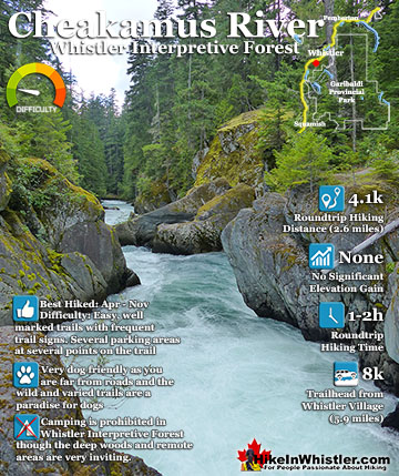
Cheakamus River
![]() Cheakamus River is a beautiful, crashing, turquoise coloured river that flows from Cheakamus Lake, through Whistler Interpretive Forest at Cheakamus Crossing, then down past Brandywine Falls to Daisy Lake. Also a popular kayaking route, the main attraction to Cheakamus River is the wonderful and quite extensive network of hiking and biking trails that run along either side of it. The Riverside trail and the Farside trail run on either side of Cheakamus River and connect at both ends by bridges. Connecting to the Riverside trail is the short trail to Logger's Lake, which in turn is surrounded by more hiking and biking trails. The Lake Loop trail, Crater Rim trail, the Ridge trail, Upper Ridge trail, and the Lower Ridge trail. On the Farside trail along Cheakamus River you can connect to Cheakamus Road(gravel road) and hike 6 kilometres up to the Cheakamus Lake trailhead. On the other side of the neighbourhood of Cheakamus Crossing, which Cheakamus River bends around keeping the Sea to Sky Highway and train tracks on its opposite side, you find still more hiking and biking trails. Trash trail hugs the river all the way to the beautiful bridge to Whistler Train Wreck. Or, continue past the bridge to connect with the Sea to Sky trail. For the most part, however, if you are talking about the Cheakamus River trails you are likely talking about the Farside and Riverside trails in Whistler's Interpretive Forest. Continued here...
Cheakamus River is a beautiful, crashing, turquoise coloured river that flows from Cheakamus Lake, through Whistler Interpretive Forest at Cheakamus Crossing, then down past Brandywine Falls to Daisy Lake. Also a popular kayaking route, the main attraction to Cheakamus River is the wonderful and quite extensive network of hiking and biking trails that run along either side of it. The Riverside trail and the Farside trail run on either side of Cheakamus River and connect at both ends by bridges. Connecting to the Riverside trail is the short trail to Logger's Lake, which in turn is surrounded by more hiking and biking trails. The Lake Loop trail, Crater Rim trail, the Ridge trail, Upper Ridge trail, and the Lower Ridge trail. On the Farside trail along Cheakamus River you can connect to Cheakamus Road(gravel road) and hike 6 kilometres up to the Cheakamus Lake trailhead. On the other side of the neighbourhood of Cheakamus Crossing, which Cheakamus River bends around keeping the Sea to Sky Highway and train tracks on its opposite side, you find still more hiking and biking trails. Trash trail hugs the river all the way to the beautiful bridge to Whistler Train Wreck. Or, continue past the bridge to connect with the Sea to Sky trail. For the most part, however, if you are talking about the Cheakamus River trails you are likely talking about the Farside and Riverside trails in Whistler's Interpretive Forest. Continued here...


Whistler's Best Hiking Trails!
Whistler & Garibaldi Park Best Hiking by Month!


Explore BC Hiking Destinations!

Whistler Hiking Trails

Squamish Hiking Trails

Vancouver Hiking Trails

Clayoquot Hiking Trails
Victoria Hiking Trails

