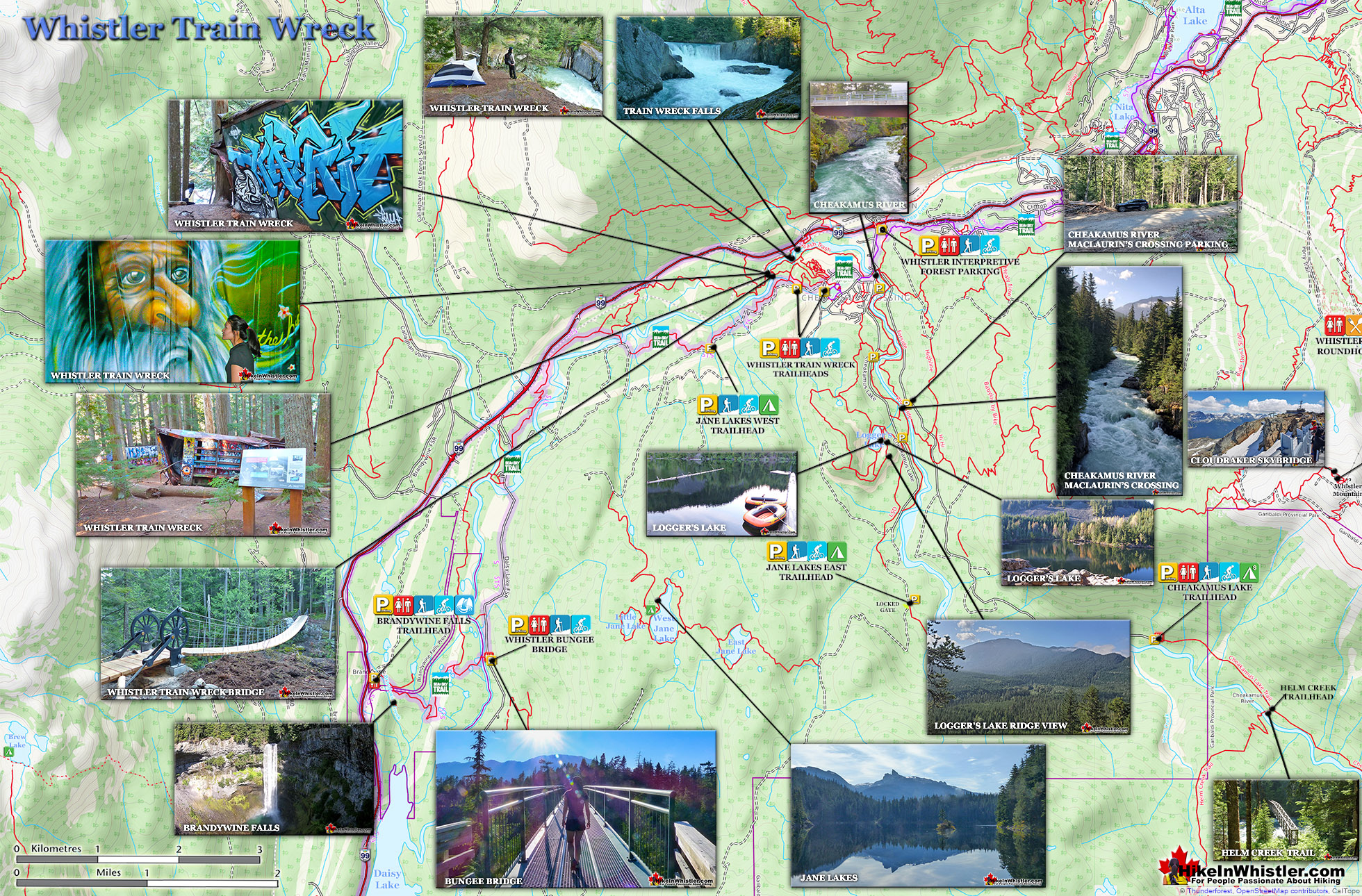
HikeInWhistler.com

HikeInWhistler.com

Menu
  • Hike
      • Alexander Falls Provincial Park
      • Ancient Cedars & Showh Lakes
      • Black Tusk in Garibaldi Park
      • Blackcomb Mountain Hiking Trails
      • Brandywine Falls Provincial Park
      • Brandywine Meadows
      • Brew Lake & Brew Mountain
      • Callaghan Lake Provincial Park
      • Cheakamus Lake in Garibaldi Park
      • Cheakamus River & Interpretive Forest
      • Cirque Lake in Callaghan Valley
      • Flank Trail (Rainbow-Sproatt)
      • Garibaldi Lake in Garibaldi Park
      • Helm Creek in Garibaldi Park
      • Jane Lakes West
      • Joffre Lakes Provincial Park
      • Keyhole Hot Springs
      • Logger's Lake & Interpretive Forest
      • Madeley Lake in Callaghan Valley
      • Meager Hot Springs
      • Nairn Falls Provincial Park
      • Newt Lake & Ancient Cedars
      • Panorama Ridge in Garibaldi Park
      • Parkhurst Ghost Town
      • Rainbow Falls
      • Rainbow Lake
      • Ring Lake & Conflict Lake
      • Russet Lake in Garibaldi Park
      • Sea to Sky Trail
      • Skookumchuck Hot Springs
      • Sloquet Hot Springs
      • Sproatt Alpine Trails
      • Taylor Meadows in Garibaldi Park
      • Train Wreck & Trash Trail
      • Wedgemount Lake in Garibaldi Park
      • Whistler Mountain Hiking Trails
  • Snow
      • Blueberry Trail Snowshoeing
      • Brandywine Falls Snowshoeing
      • Cheakamus River Snowshoeing
      • Elfin Lakes Snowshoeing
      • Flank Trail Snowshoeing
      • Joffre Lakes Snowshoeing
      • Nairn Falls Snowshoeing
      • Parkhurst Ghost Town Snowshoeing
      • Rainbow Falls Snowshoeing
      • Rainbow Lake Snowshoeing
      • Rainbow Park Snowshoeing
      • Taylor Meadows Snowshoeing
      • Train Wreck Snowshoeing
      • Wedgemount Lake Snowshoeing
  • Run
      • Whistler Golf Course 5k(3.1 Mile)
      • Blueberry Hill 6k(3.7 Mile)
      • Lost Lake 6k(3.7 Mile)
      • Alta Lake 8k(5 Mile)
      • Fitzsimmons Creek 9k(5.6 Mile)
      • Alta Green Lost 15k(9.3 Mile)
  • Best
      • Best Whistler Parks & Beaches
      • Best Whistler Waterfalls
      • Best Whistler Aerial Views
      • Best Whistler Hiking by Month
      • Best Whistler Snowshoeing
      • Best Whistler Running Trails
      • Best Whistler Hiking Trails
      • Best Squamish Hiking Trails
      • Best Vancouver Hiking Trails
      • Best Whistler Hiking Gear Rentals
  • AtoZ
      • Ablation Zone
      • Accumulation Zone
      • Adit Lakes
      • Aiguille
      • Alpine Zone
      • Arête
      • Armchair Glacier
      • A River Runs Through It
      • The Barrier
      • Bears
      • Bench
      • Bergschrund or Schrund
      • Bivouac or Bivy
      • Cairns & Inukshuks
      • Chimney
      • Cirque or Cirque Lake
      • Cloudraker Skybridge
      • Coast Mountains
      • Col
      • Crevasse
      • Deadfall
      • Erratic or Glacier Erratic
      • The Fissile
      • Fitzsimmons Creek
      • Fitzsimmons Range
      • Garibaldi Ranges
      • Garibaldi Volcanic Belt
      • Gemel or Inosculation
      • Glacier Window
      • Green Lake
      • Hoary Marmot
      • Krummholz
      • Moraine
      • Mount Garibaldi
      • Mount James Turner
      • Northair Mine
      • Nunatuk
      • Overlord Mountain & Glacier
      • Peak2Peak Gondola
      • Roundhouse Lodge
      • Rubble Creek
      • Spearhead Range
      • Tarn
      • The Table
      • Usnea or Old Man's Beard
  • Maps
      • Alexander Falls Map
      • Ancient Cedars Map
      • Black Tusk Map
      • Blackcomb Mountain Map
      • Brandywine Falls Map
      • Brandywine Meadows Map
      • Brew Lake Map
      • Callaghan Lake Map
      • Cheakamus Lake Map
      • Cheakamus River Map
      • Cirque Lake Map
      • Garibaldi Lake Map
      • Helm Creek Map
      • Joffre Lakes Map
      • Keyhole Hot Springs Map
      • Logger's Lake Map
      • Madeley Lake Map
      • Meager Hot Springs Map
      • Nairn Falls Map
      • Panorama Ridge Map
      • Parkhurst Map
      • Rainbow Falls Map
      • Rainbow Lake Map
      • Ring Lake Map
      • Russet Lake Map
      • Skookumchuck Map
      • Sloquet Map
      • Sproatt Map
      • Taylor Meadows Map
      • Train Wreck Map
      • Wedgemount Lake Map
      • Whistler Mountain Map
  • News
      • Whistler Hiking News & Blog
      • Live Whistler Webcams
      • Garibaldi Provincial Park
      • Hike in Whistler Glossary

Whistler Train Wreck

Black Tusk

Brandywine Meadows

Panorama Ridge

Wedgemount Lake

Rainbow Falls

Cirque Lake

Sloquet Hot Springs

Snowshoeing in Whistler!

Whistler is amazing for snowshoeing! The Flank Trail, Rainbow Falls, Cheakamus River, Taylor Meadows are all fantastic to explore when there is a ton of snow on the ground! Check out our Best Snowshoeing Trails in Whistler here!

Garibaldi Provincial Park!

This is the first winter where the Rubble Creek trailhead to Garibaldi Provincial Park will be snowplowed! Now you can snowshoe from the trailhead to Garibaldi Lake, Taylor Meadows and deep into Garibaldi Provincial Park!

Whistler Hiking Trail RatingThe trail to Whistler Train Wreck is an easy, yet varied route through deep forest, across a great suspension bridge over Cheakamus River, to a stunning array of wrecked train cars. The trail from your car to the wrecks only takes about 15 minutes, however once you reach one wreck, you see another, then another. There are seven wrecks in total that are spread over an area about 400 metres long.

  • Surreal combination of wreckage & serene forest
  • Many excellent views of Cheakamus River
  • Insane place to have a drink with friends
  • Unbeatable place to have a picnic on the river
  • Accessible year-round and on bus route
  • Bike friendly & surrounded by endless bike trails
  • Dozens of amazing areas to spend the night
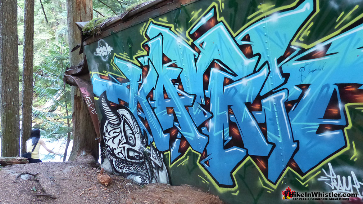
  • Graffiti art is always changing & interesting
  • Sea to Sky Trail runs past nearby
  • Paintings often covered with boring graffiti

Along with the surreal train wrecks painted with stunning murals, you find yourself in a thick forest that runs along Cheakamus River. Cheakamus River is a beautiful, wild and crashing river that snakes past the train wrecks. Numerous side trails take you to some marvellous viewpoints, several metres above the rushing water below.  If you follow a trail past the wrecks(heading north or in the direction of Whistler Village) you will emerge at the train tracks. If you are adventurous you will then walk along, beside the tracks for a couple hundred metres and some truly breathtaking views of Cheakamus River.  Keep in mind that skirting the train tracks is illegal, so you must never do this if a train is in the vicinity. If you plan to bivouac under the stars, this area is a great choice. Multiple beautiful rock outcrops along and above the river and you may not get disturbed as most hikers don't risk violating the law. Camping is technically prohibited within Whistler's municipal boundary, which Train Wreck is within, yet a sleeping bag under the stars will almost certainly go unnoticed. If bivouacking or stealth camping is what you are after, you will find quite a lot to choose from as you hike in along the Train Wreck trail. 

Whistler Train Wreck is located along Cheakamus River over several hundred metres of scenic, and deep forest. The trailhead can be found in Cheakamus Crossing, a neighbourhood 8 kilometres south of Whistler Village. The area is home to quite a variety of hiking and biking trails, both old and new. The Whistler Train Wreck trail from Cheakamus Crossing was only established in 2016 after construction of a beautiful bridge over Cheakamus River.

Whistler Train Wreck Map

Whistler Train Wreck Bridge Sign

Whistler Train Wreck History Sign

Whistler Train Wreck - Graffiti

Whistler Train Wreck Kups Art

Trailhead & Parking Directions to Whistler Train Wreck

Parking & Trailhead DirectionsPublic Transit Directions to Whistler Train WreckThe Whistler Train Wreck is one of the easiest hiking trails in Whistler to get to by car, bike or public transit.  Public transit runs continuously between Whistler Village and Cheakamus Crossing for just $3 one-way.  The bus will drop you off at the HI Hostel and a short section of the Sea to Sky Trail connects you to the Trash Trail and Train Wreck.  If you would rather bike to the trailhead you are in for a treat.  From anywhere in Whistler the bike ride to Train Wreck is very nice.  Whistler's Valley Trail system and the Sea to Sky Trail connect you to Cheakamus Crossing from Whistler Village with only one road crossing!  The wide, two lane, paved Valley Trail takes you through some beautiful scenery and along three lakes.  Only 9 kilometres by bike, Whistler Train Wreck is easily within reach by bike.  Walking to the Train Wreck trailhead is a possible option as well.  The same route as by bike, you will pass by some amazing scenery and get from Whistler Village to the trailhead in well under 3 hours.

Whistler Train Wreck Driving Directions Map

To get to the trailhead for Whistler Train Wreck, drive 7.9 kilometres south of Whistler Village(Village Gate Boulevard).  At the traffic lights at Function Junction turn left onto Cheakamus Lake Road.  At 8.6 kilometres, just after you cross the bridge over Cheakamus River, turn right.  At 9.2 kilometres you will see the unmarked parking area on the left side of the road, across from the Whistler Train Wreck and Sea to Sky Trail trailhead. 

Trailhead Parking for Whistler Train Wreck

More Whistler Train Wreck Info...

Whistler Hiking Trail MapAlexander Falls Maps  Whistler Hiking Trail MapAncient Cedars Maps  Whistler Hiking Trail MapBlack Tusk Maps  Whistler Hiking Trail MapBlackcomb Maps  Whistler Hiking Trail MapBrandywine Falls Maps  Whistler Hiking Trail MapBrandywine Meadows Maps  Whistler Hiking Trail MapBrew Lake Maps  Whistler Hiking Trail MapCallaghan Lake Maps  Whistler Hiking Trail MapCheakamus Lake Maps  Whistler Hiking Trail MapCheakamus River Maps  Whistler Hiking Trail MapCirque Lake Maps  Whistler Hiking Trail MapGaribaldi Lake Maps  Whistler Hiking Trail MapHelm Creek Maps  Whistler Hiking Trail MapJoffre Lakes Maps  Whistler Hiking Trail MapKeyhole Maps  Whistler Hiking Trail MapLogger’s Lake Maps  Whistler Hiking Trail MapMadeley Lake Map Whistler Hiking Trail Map
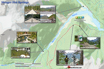
Meager Hot Springs Maps
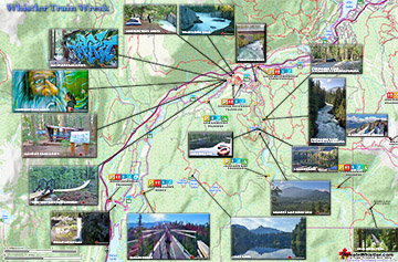
  Whistler Hiking Trail MapNairn Falls Maps  Whistler Hiking Trail MapPanorama Ridge Maps  Whistler Hiking Trail MapParkhurst Maps  Whistler Hiking Trail MapRainbow Falls Maps  Whistler Hiking Trail MapRainbow Lake Maps  Whistler Hiking Trail MapRing Lake Maps  Whistler Hiking Trail MapRusset Lake Maps  Whistler Hiking Trail MapSkookumchuck Maps  Whistler Hiking Trail MapSloquet Hot Springs Maps  Whistler Hiking Trail MapSproatt Maps  Whistler Hiking Trail MapTaylor Meadows Maps  Whistler Hiking Trail MapTrain Wreck Maps  Whistler Hiking Trail MapWedgemount Lake Maps  Whistler Hiking Trail MapWhistler Mountain Maps

Vancouver Garibaldi Hiking Camping Rental

Whistler & Garibaldi Park Hiking

Easy Hiking Trail WhistlerAlexander Falls  Moderate Hiking Trail Whistler Dog FriendlyAncient Cedars  Moderate Hiking Trail WhistlerBlack Tusk  Pay Use Hiking Trail WhistlerBlackcomb Mountain  Easy Hiking Trail WhistlerBrandywine Falls  Moderate/Hard Hiking Trail Whistler Dog FriendlyBrandywine Meadows  Moderate/Hard Hiking Trail Whistler Dog FriendlyBrew Lake  Easy Hiking Trail WhistlerCallaghan Lake  Moderate Hiking Trail WhistlerCheakamus Lake  Whistler Hiking Trail EasyCheakamus River  Whistler Hiking Trail HardCirque Lake  Whistler Hiking Trail EasyFlank Trail  Moderate Hiking Trail WhistlerGaribaldi Lake  Moderate Hiking Trail WhistlerGaribaldi Park  Moderate Hiking Trail WhistlerHelm Creek  Joffre Lakes Hike in Whistler in SeptemberJoffre Lakes  Moderate Hiking Trail Whistler Dog FriendlyKeyhole Hot Springs  Hiking Trail Hard Dog FriendlyLogger’s Lake  Whistler Hiking Trail EasyMadeley Lake  Moderate/Hard Hiking Trail Whistler Dog FriendlyMeager Hot Springs Easy Hiking Trail WhistlerNairn Falls  Moderate Hiking Trail WhistlerPanorama Ridge  Easy Hiking Trail WhistlerParkhurst Ghost Town  Hiking Trail ModerateRainbow Falls  Moderate Hiking Trail WhistlerRainbow Lake  Moderate/Hard Hiking Trail Whistler Dog FriendlyRing Lake  Moderate Hiking Trail WhistlerRusset Lake  Whistler Hiking Trail EasySea to Sky Trail  Easy Hiking Trail WhistlerSkookumchuck Hot Springs  Easy Hiking Trail WhistlerSloquet Hot Springs  Moderate/Hard Hiking Trail Whistler Dog FriendlyMount Sproatt  Moderate Hiking Trail WhistlerTaylor Meadows  Whistler Hiking Trail EasyTrain Wreck  Hiking Trail Hard - Whistler TrailsWedgemount Lake  Pay Use Hiking Trail WhistlerWhistler Mountain

Hike in Whistler GlossaryThe Barrier  Hike in Whistler GlossaryBears  Hike in Whistler GlossaryCloudraker Skybridge  Hike in Whistler GlossaryCoast Mountains  Hike in Whistler GlossaryErratic  Hike in Whistler GlossaryThe Fissile  Hike in Whistler GlossaryFitzsimmons Range  Hike in Whistler GlossaryGaribaldi Ranges  Hike in Whistler GlossaryGaribaldi Volcanic Belt Hike in Whistler GlossaryGreen Lake  Hike in Whistler GlossaryHoary Marmot Hike in Whistler GlossaryKrummholz  Hike in Whistler GlossaryMount Garibaldi  Hike in Whistler GlossaryOverlord  Hike in Whistler GlossaryPeak2Peak  Hike in Whistler GlossaryRoundhouse  Hike in Whistler GlossaryRubble Creek  Hike in Whistler GlossarySpearhead Range

Best Hiking by Month

There are plenty of beautiful and free snowshoe trails in Whistler and Garibaldi Provincial Park.  From the surreal paintings of Whistler Train Wreck to ...
Read more
February is a great month for snowshoeing in Whistler and Garibaldi Park.  The days slowly get longer, but the temperatures stay consistently cold.  Expect ...
Read more
In the(usually) deep March snow of Whistler you have an amazing array of snowshoeing options.  If you have not been to the Whistler Train Wreck, you have to, ...
Read more
April in Whistler is a wonderful time of year.  The winter deep freeze ends and T-shirt weather erupts.  The village comes alive with the World Ski & ...
Read more
Best Whistler Hiking Trails by Month

Best Whistler Aerial Views

Keyhole Falls are found just a couple kilometres upriver from Keyhole Hot Springs.  The unmarked trailhead and parking area for Keyhole Falls are just a ...
Read more
Wedgemount Lake itself is a magnificent destination for a day hike or spectacular overnight beneath the dazzling mountain peaks and stars above Garibaldi ...
Read more
Callaghan Lake is a stunning lake high up in the Callaghan Valley that you can drive to from Whistler Village in less than an hour.  The very potholed and ...
Read more
Panorama Ridge is easily one of the most amazing hikes in Garibaldi Provincial Park.  The 15 kilometre hike from the trailhead at Rubble Creek to Panorama ...
Read more
More Best Whistler Aerial Views

Whistler Hiking Trails

Brandywine Meadows is a nice, relatively short hike to a massive flower filled valley high up in Callaghan Valley. Located 40 minutes south of Whistler, this tough and sometimes muddy trail gains a huge 550 ...
Read more
Helm Creek is a cute, meandering creek that winds its way from beyond Black Tusk, down the valley to the wonderful campground that takes its name. From the Helm Creek campground, Helm Creek descends further ...
Read more
The Rainbow Trail is a convenient and popular trail near Whistler Village that takes you to Rainbow Lake as well as the Rainbow-Sproatt Flank Trail, Rainbow Falls, Hanging Lake, Madeley Lake, Beverley ...
Read more
Black Tusk is the extraordinarily iconic and appropriately named mountain that can be seen from almost everywhere in Whistler.  The massive black spire of crumbling rock juts out of the earth in an incredibly ...
Read more
More Whistler Hiking Trails & Maps

HikeInWhistler.com HikeInWhistler.com © 2021

Booking.com

  • Contact Us: [email protected]