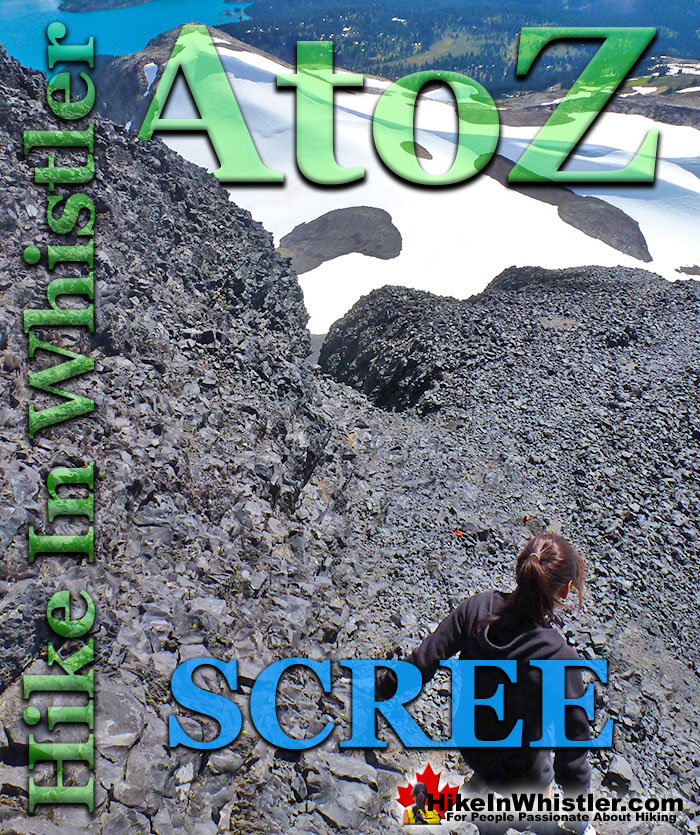
Scree: from the Norse “skridha”, landslide. The small, loose stones covering a slope. Also called talus, the French word for slope. Scree is mainly formed from the annual freeze/thaw periods of spring and fall, where water seeps into cracks in the rock and expands when freezing. Scree slopes are a common obstacle or simply part of the scenery around Whistler. The terrain at Wedgemount Lake is dominated by scree slopes and a massive erratic field around the lake.
Black Tusk in Garibaldi Park near Whistler is a crumbling mountain blanketed in scree. From the top of Black Tusk, to its steep chimney climb, jet-black chunks of rock crumble down the scree slopes everywhere you look. Black Tusk is the extraordinarily iconic and appropriately named mountain that can be seen from almost everywhere in Whistler. The massive black spire of crumbling rock juts out of the earth in an incredibly distinct way that appears like an enormous black tusk plunging out of the ground. Whether you spot it in the distance from the top of Whistler Mountain or from vantage points along the Sea to Sky Highway, its appearance is breathtaking. Black Tusk, created in the fires of the Garibaldi Volcanic Belt and is one of the most admired and hiked to destinations in Garibaldi Provincial Park. Every angle you look at it, from far away, to closer vantage points such as Taylor Meadows, Helm Creek, Panorama Ridge or Garibaldi Lake. All views give you the certain belief that it mus be impossible to hike to the top. In fact, Black Tusk seems to look more impossible to climb the closer you get to it. Even when you are close enough to touch its vertical, black and crumbling sides, you wonder in amazement how anyone can possible get up to the peak of this incredible mountain. Black Tusk is near the centre of Garibaldi Park, and is accessible from three different trailheads, all accessible via old access roads.
More Whistler & Garibaldi Park Hiking A to Z!
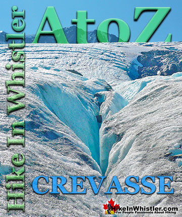
Crevasse: is a split or crack in the glacier surface, often with near vertical walls. Crevasses form out of the constant movement of a glacier over ...
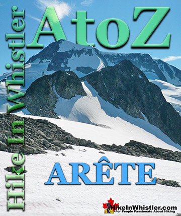
Arête: a thin ridge of rock formed by two glaciers parallel to each other. Sometimes formed from two cirques meeting. From the French for edge or ridge. Around ...
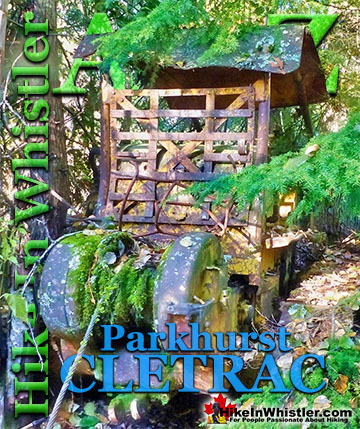
Adjacent to the huge Caterpillar tractor in Parkhurst is a large disintegrating wooden dock that is a great place to take in the wonderful view of Green ...
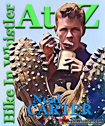
Neal Carter (14 Dec 1902 – 15 Mar 1978) was a mountaineer and early explorer of the Coast Mountains primarily in the 1920’s and 1930’s. Astoundingly skilled as a ...
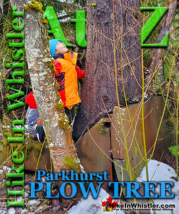
Hidden in the tangle of forest along Green Lake where the old Parkhurst Sawmill once operated, is the bizarre and beautiful Parkhurst Plow Tree. A very ...
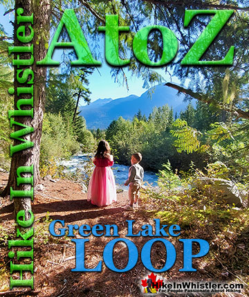
The Green Lake Loop is the original trail that runs around the back side of Green Lake. Before the Sea to Sky Highway was cut through the valley in 1964, ...
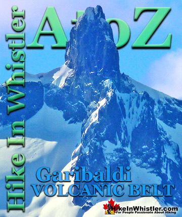
The Garibaldi Volcanic Belt is a line of mostly dormant stratovolcanoes and subglacial volcanoes largely centred around Whistler and extending through much ...
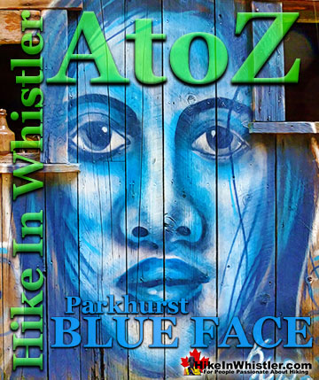
Back in 2011 Kups, a Whistler local and now professional muralist painted a hauntingly surreal, blue face on the side of this house. This beautiful ...
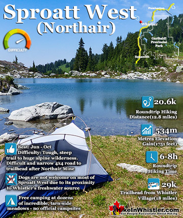
Mount Sproatt, or as it is known locally as just Sproatt, is one of the many towering mountains visible from Whistler Village. Above and beyond Alta Lake, directly across from Whistler Mountain and ...
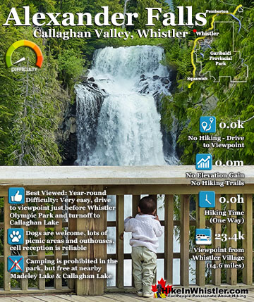
Alexander Falls is a very impressive 43 metre/141 foot waterfall just 30 to 40 minutes south of Whistler in the Callaghan Valley. Open year-round and located just before Whistler Olympic Park where several ...
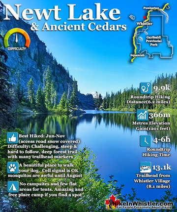
Newt Lake is cute little hidden lake high up on the far side of Cougar Mountain near Ancient Cedars. Its location is a wonderful mix of unexpected characteristics that combine to make it a gorgeous place to ...
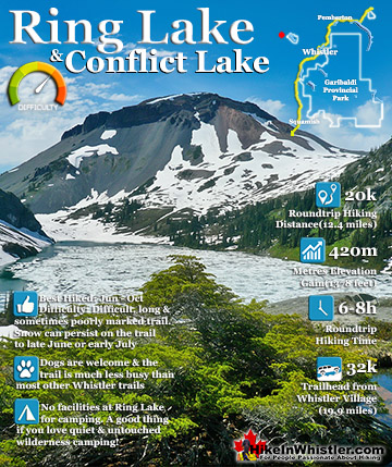
Ring Lake is a fantastically serene and wonderfully remote lake similar to Cirque Lake, but considerably farther to hike to reach it. The 10 kilometre(6.2 mile) hike takes you through a rarely hiked forest, ...
July is a wonderful time to hike in Whistler and Garibaldi Provincial Park. The weather is beautiful and the snow on high elevation hiking trails is long ...
August hiking in Whistler definitely has the most consistently great, hot weather. You can feel the rare pleasure of walking across a glacier shirtless and ...
September hiking in Whistler is possibly the best month of all. The snow has melted far up to the mountain tops, yet the temperatures are still quite ...
Hiking in Whistler in October is often unexpectedly stunning. The days are much shorter and colder but the mountains are alive with colour from the fall ...
Hiking in Whistler is spectacular and wonderfully varied. Looking at a map of Whistler you see an extraordinary spider web of hiking trails that are unbelievably numerous. Easy trails, moderate trails and challenging hiking trails are all available. Another marvellous ...
Squamish is located in the midst of a staggering array of amazing hiking trails. Garibaldi Provincial Park sprawls alongside Squamish and up and beyond Whistler. Tantalus Provincial Park lays across the valley to the west and the wonderfully remote Callaghan Valley ...
Vancouver is surrounded by seemingly endless hiking trails and mountains to explore. Massive parks line up one after another. Mount Seymour Provincial Park, Lynn Canyon Park, Grouse Mountain, Cypress Park and the enormous Garibaldi Park all contribute to Vancouver ...
Clayoquot Sound has a staggering array of hiking trails within it. Between Tofino and Ucluelet, Pacific Rim Park has several wilderness and beach trails, each one radically different from the last. The islands in the area are often Provincial parks on their own with ...
Victoria has a seemingly endless number of amazing hiking trails. Most take you to wild and beautiful Pacific Ocean views and others take you to tranquil lakes in beautiful BC Coastal Rainforest wilderness. Regional Parks and Provincial Parks are everywhere you turn ...
The West Coast Trail was created after decades of brutal and costly shipwrecks occurred along the West Coast of Vancouver Island. One shipwreck in particular was so horrific, tragic and unbelievable that it forced the creation of a trail along the coast, which ...