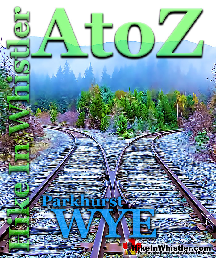
![]() When hiking to Parkhurst Ghost Town, the first area you will encounter after you cross the disintegrating bridge over Wedge Creek is the wye. In railroad terminology a wye is a large turnaround area which traces a large triangle shape and allows trains to exit the main train tracks and turnaround. The original wye in the area was Mons Wye located about where the Catholic church at the end of Lorimer Road is today.
When hiking to Parkhurst Ghost Town, the first area you will encounter after you cross the disintegrating bridge over Wedge Creek is the wye. In railroad terminology a wye is a large turnaround area which traces a large triangle shape and allows trains to exit the main train tracks and turnaround. The original wye in the area was Mons Wye located about where the Catholic church at the end of Lorimer Road is today.
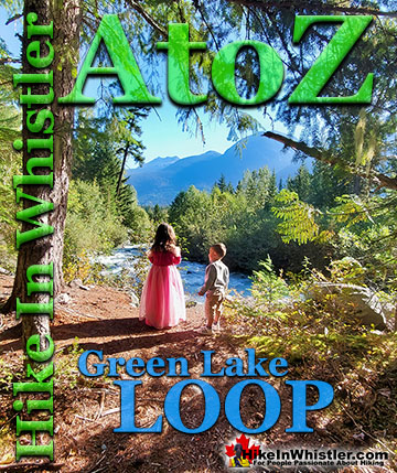
Whistler & Garibaldi Hiking
![]() Alexander Falls
Alexander Falls ![]() Ancient Cedars
Ancient Cedars ![]() Black Tusk
Black Tusk ![]() Blackcomb Mountain
Blackcomb Mountain ![]() Brandywine Falls
Brandywine Falls ![]() Brandywine Meadows
Brandywine Meadows ![]() Brew Lake
Brew Lake ![]() Callaghan Lake
Callaghan Lake ![]() Cheakamus Lake
Cheakamus Lake ![]() Cheakamus River
Cheakamus River ![]() Cirque Lake
Cirque Lake ![]() Flank Trail
Flank Trail ![]() Garibaldi Lake
Garibaldi Lake ![]() Garibaldi Park
Garibaldi Park ![]() Helm Creek
Helm Creek ![]() Jane Lakes
Jane Lakes ![]() Joffre Lakes
Joffre Lakes ![]() Keyhole Hot Springs
Keyhole Hot Springs ![]() Logger’s Lake
Logger’s Lake ![]() Madeley Lake
Madeley Lake ![]() Meager Hot Springs
Meager Hot Springs ![]() Nairn Falls
Nairn Falls ![]() Newt Lake
Newt Lake ![]() Panorama Ridge
Panorama Ridge ![]() Parkhurst Ghost Town
Parkhurst Ghost Town ![]() Rainbow Falls
Rainbow Falls ![]() Rainbow Lake
Rainbow Lake ![]() Ring Lake
Ring Lake ![]() Russet Lake
Russet Lake ![]() Sea to Sky Trail
Sea to Sky Trail ![]() Skookumchuck Hot Springs
Skookumchuck Hot Springs ![]() Sloquet Hot Springs
Sloquet Hot Springs ![]() Sproatt East
Sproatt East ![]() Sproatt West
Sproatt West ![]() Taylor Meadows
Taylor Meadows ![]() Train Wreck
Train Wreck ![]() Wedgemount Lake
Wedgemount Lake ![]() Whistler Mountain
Whistler Mountain
![]() January
January ![]() February
February ![]() March
March ![]() April
April ![]() May
May ![]() June
June ![]() July
July ![]() August
August ![]() September
September ![]() October
October ![]() November
November ![]() December
December
In 1914 the railroad was under construction and the Mons Wye was used frequently as a turnaround point. Maps of Whistler as recently as the 1980's show Mons Wye as still located there. Most of the development at the end of Lorimer Road happened in the mid 1990's, so it seems likely the the wye was removed well before then, and possibly reconstructed at Parkhurst. The Parkhurst Wye doesn't appear on any old maps, so it seems possible that when the Mons Wye was removed, the Parkhurst Wye was built, likely in the 1980's as well. The Parkhurst Wye is not very scenic as it is just a large, flat gravel area with an industrial feel. It is just the quickest way to get to the Parkhurst/Green Lake Loop Trail entrance into the forest at the far end of the wye. The Parkhurst Wye does have some unexpected highlights that are particularly nice on a sunny day. When hiking towards Parkhurst you get a nice, clear view of Rainbow Mountain in the distance between a gap in the hills. From this angle it is hard to recognize and takes a moment to figure out which snowy peak is so strangely close and unfamiliar. Rainbow Mountain doesn't have nice, eye catching, defining features like many other mountains in the area. If you look in the opposite direction you can help but recognized the row of mountain peaks visible from almost everywhere in Whistler. Mount Cook, Armchair Glacier, Mount Weart and Wedge Mountain. Wedge and Weart are the two highest mountains in the Garibaldi Ranges and Armchair Glacier stretches across the face of Weart to Mount Cook. On a sunny day these pure white, jagged peaks look wonderfully close.

Parkhurst Wye Winter Wonderland
In the middle of winter when the sun is is low in the sky, the wye is the only part of this hike you will get lots of sun and becomes a winter wonderland. Even in the summer, much of the various trails around Parkhurst are through deep forest. Opposite the main tracks from here you have quite a deep, dark forest running along Green River. Here you will find a few signs of the old Parkhurst as well as a well-defined, though very overgrown dirt road. Hiking and sometimes bushwhacking through this forest eventually squeezes you between Green River and the train tracks and you emerge near where the Parkhurst/Green Lake Loop Trail enters the forest.
Parkhurst Wye View of Rainbow Mountain

Parkhurst Wye Buried in Snow
The winter wonderland view of Rainbow Mountain you get as soon as you enter the Parkhurst Wye after crossing the Wedge Creek bridge. Much of the year, and certainly in the winter months Parkhurst is seldom hiked. In weeks where you get significant snowfall you will find the wye looking like this. Usually you find no human footprints, but instead tracks from rabbits and sometimes deer. As you walk alongside the train tracks you will see animal track zigzag back and forth through the otherwise pristine snow. It is wonderful to consider that the human to animal ratio in this winter paradise is about one to one on any given day!
Rainbow Mountain from the Parkhurst Wye

Mountain Views from the Parkhurst Wye
Looking north on a sunny, summer day gives you an amazing panorama of several beautiful mountains in Garibaldi Provincial Park. Mount Cook on the left, Armchair Glacier, Mount Weart, Rethel Mountain, Wedge Mountain and Parkhurst Mountain.

Parkhurst Wye View of Armchair Glacier
Below is a close up view of Armchair Glacier. Usually referred to as the Armchair or Armchair Mountain, this second highest peak in the Garibaldi Ranges was officially renamed Mount Weart a few years back. Weart's neighbour Wedge Mountain is the highest mountain in the Garibaldi Ranges and Wedgemount Lake is one of the most beautiful hikes in Garibaldi Park.

The Parkhurst Wye in Summer
Parkhurst Wye bends around to meet up with the opposite bend coming from the other side. They meet and come to a dead end in an area that allows the train to switch over and come out the other side reversed.

The Abrupt End of Parkhurst Wye

The Parkhurst Wye Return

Parkhurst Wye Stealth Camping
Just off to side of the Parkhurst Wye is a nice little area covered in an emerald coloured moss. A trail then runs up to connect with the Sea to Sky Trail. In the summer months when Whistler is bustling with activity, finding a quiet place to put up your tent is a wonderful thing.
Stealth Camping Near the Parkhurst Wye


Parkhurst Wye and Mons Wye
The map below is a BC forestry map from 1957 that shows the Mons Wye in the bottom left corner near Alta Lake in what is Whistler Cay today. It was located near where the Catholic Church is today at the end of Lorimer Road. The Parkhurst Wye is noticeably missing from the map and possibly was built in the 1980's or early 1990's when the Mons Wye was removed and development in the area increased. On December 24th 1980 there was a once in a century flood in Whistler and most notably from Fitzsimmons Creek and Twentyone Mile Creek. Where Twentyone Mile Creek and the River of Golden Dreams meet near the end of Lorimer Road there was massive flooding. The measures taken in the area to prevent future flooding may have hastened the removal of the old Mons Wye.
Mons Wye on a BC Forestry Map from 1957

According to John Burge, in 1914 the wye was at the end of the still under construction railway and was named after the Battle of Mons, the first major battle of World War I for the British against the Germans and widely report that year. He recalls that in the 1960's the Mons Wye was no longer used and the trail between Rainbow Lodge and Tapley's farm crossed it. You can see the trail on the original 1928 map of Garibaldi Park marked with the red arrow on the left. The right arrow points to where the Parkhurst Wye is today.

On the map on the lower left corner "Mons" is written about where Scotia Creek is as this was the location of the Mons train station, which in later years was renamed Alta Lake train station.
Mons Crossing in Whistler
In Whistler today Mons is a name that has moved a bit further north along the train tracks near the south end of Green Lake where Mons Road is. There is the industrial park there as well as Riverside Campground and the train tracks run past the industrial park with Nicklaus North Golf Course on the other side of the tracks. There are two and part of the way three, tracks running parallel here and the dual tracks run from about 500 metres north of the end of Lorimer Road in Whistler Cay and north all the way to Fitzsimmons Creek near the Nicklaus North parking lot. This section of parallel tracks and to some degree, the regions around it covers the area that we today refer to as "Mons". The Sea to Sky Highway overpass over the train track in this area is called Mons Crossing. Below is an excellent video of the 2016 construction of the much newer Mons Crossing underpass for the Valley Trail.
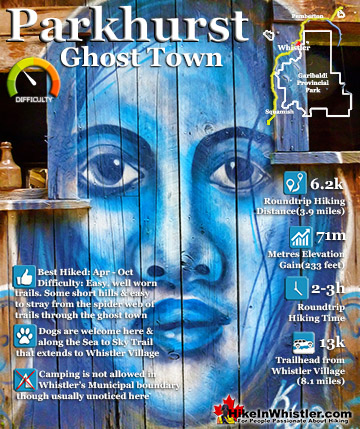
Parkhurst Ghost Town
![]() Parkhurst Ghost Town is a beautiful and comparatively quiet place to hike in Whistler. An ever increasing network of hiking and biking trails over the years have made it quite an accessible place to get to from either the Sea to Sky Trail/Green Lake Loop Trail from Lost Lake near Whistler Village or via the Parkhurst Trail at the far end of Green Lake. A short drive from Whistler Village along the Sea to Sky Highway past the north end of Green Lake takes you to the trailhead for the Parkhurst Trail and the short hike to Parkhurst. The highlights of Parkhurst Ghost Town are not just the interesting old relics of the abandoned town, but the gorgeous views of Green Lake from several places along the Parkhurst Ridge Trail.
Parkhurst Ghost Town is a beautiful and comparatively quiet place to hike in Whistler. An ever increasing network of hiking and biking trails over the years have made it quite an accessible place to get to from either the Sea to Sky Trail/Green Lake Loop Trail from Lost Lake near Whistler Village or via the Parkhurst Trail at the far end of Green Lake. A short drive from Whistler Village along the Sea to Sky Highway past the north end of Green Lake takes you to the trailhead for the Parkhurst Trail and the short hike to Parkhurst. The highlights of Parkhurst Ghost Town are not just the interesting old relics of the abandoned town, but the gorgeous views of Green Lake from several places along the Parkhurst Ridge Trail.


The Parkhurst Loop Trail
![]() The Parkhurst Loop Trail is roughly a triangle with each side about 300 metres long. This trail runs through the now deep forest where most of the houses once stood in Parkhurst. Part of the loop trail was once an old gravel road which explains how the various wrecked vehicles managed to get there. Wrecked, old trucks from the 1950’s, an old car from the 1970’s and dozens of collapsed houses lay rotting along this trail. It is fun to wander through the forest here as you can never tell what you will find around the next bend in the trail. The triangle shaped loop trail surrounded by deep forest is strangely disorienting. You find yourself wandering for a while in a direction you are sure is away from Green Lake, only to suddenly emerge from the forest just steps from the water. Unlike other hiking trails in Whistler where you have a set destination, at Parkhurst you have a non-stop series of curious structures, beautiful sections of forest and endless great lake views.
The Parkhurst Loop Trail is roughly a triangle with each side about 300 metres long. This trail runs through the now deep forest where most of the houses once stood in Parkhurst. Part of the loop trail was once an old gravel road which explains how the various wrecked vehicles managed to get there. Wrecked, old trucks from the 1950’s, an old car from the 1970’s and dozens of collapsed houses lay rotting along this trail. It is fun to wander through the forest here as you can never tell what you will find around the next bend in the trail. The triangle shaped loop trail surrounded by deep forest is strangely disorienting. You find yourself wandering for a while in a direction you are sure is away from Green Lake, only to suddenly emerge from the forest just steps from the water. Unlike other hiking trails in Whistler where you have a set destination, at Parkhurst you have a non-stop series of curious structures, beautiful sections of forest and endless great lake views.

The Parkhurst Sawmill Site
![]() The old Parkhurst Sawmill was located on the peninsula adjacent to the old Caterpillar tractor. A little bit of bushwhacking takes you into a surprisingly big clearing in tangle of forest. The clearing is caused by the collapsed sawmill's metal roof covering the forest floor and preventing big trees from taking root. You can only see some of the huge metal sheets as most of it lays under a carpet of forest that has settled in over the past 65 years. The clearing is serene and cut off from the world by a thick perimeter of jungle, making it a sunny paradise on a nice day.
The old Parkhurst Sawmill was located on the peninsula adjacent to the old Caterpillar tractor. A little bit of bushwhacking takes you into a surprisingly big clearing in tangle of forest. The clearing is caused by the collapsed sawmill's metal roof covering the forest floor and preventing big trees from taking root. You can only see some of the huge metal sheets as most of it lays under a carpet of forest that has settled in over the past 65 years. The clearing is serene and cut off from the world by a thick perimeter of jungle, making it a sunny paradise on a nice day.

Venturing into the forest around the clearing you will encounter the huge, old chimney from the sawmill as well as a pile of bricks that once housed the sawmill's furnace that powered everything. Further into the forest you will find two more logging tractors. An old Cletrac tractor that dates from the mid 1940's and an unexpectedly impressive Caterpillar buried in the forest with its huge plow being lifted off the ground by several trees. You will probably find yourself crawling around in amazement, peering under the 4000 kilogram plow, wondering how it is possible.

More Parkhurst Ghost Town Info
More Whistler & Garibaldi Park Hiking A to Z!

The Best Whistler & Garibaldi Park Hiking Trails!
Whistler & Garibaldi Park Best Hiking by Month!


Explore BC Hiking Destinations!

Whistler Hiking Trails

Squamish Hiking Trails

Vancouver Hiking Trails

Clayoquot Hiking Trails
Victoria Hiking Trails

