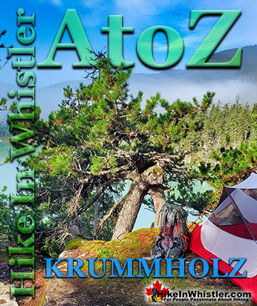
When you hike in the alpine in Whistler and Garibaldi Provincial Park, you will often encounter unbelievably hardy and sometimes mangled looking trees. Weathering high winds, freezing temperatures, deep snow and usually growing where most other things can't. These weather battered trees are called krummholz. Krummholz is a German derived word that comes from two words, krumm and holz. Krumm means bent, crooked, twisted and holz means wood.
The lodgepole pine is commonly found in the alpine regions around Whistler. There are many other types of trees that are known to form into bizarre krummholz trees, including spruce, mountain pine, balsam fir, subalpine fir and limber pine. The krummholz tree pictured here is on a cliff above Cirque Lake in the Callaghan Valley. A tremendously hostile place to live in the winter months, however, during the summer Cirque Lake is a tranquil paradise. Most krummholz trees you will see will be found growing out of a rocky landscape with just a thin layer of dirt. Often they have a short, yet very solid shape, pushing the bedrock apart as they grow. Other common krummholz trees form into a flag shape, where high winds have blasted the branches so they form on one side only. Regardless of the shape of krummholz trees, they always appear to have lived through brutal winters in improbable locations. This krummholz tree pictured below is growing out of a rocky island, one of the Battleship Islands in Garibaldi Lake, Garibaldi Provincial Park.
Below are examples of krummholz trees at Brew Lake, Garibaldi Lake and Brandywine Meadows. The Brew Lake krummholz on the bottom left is a great example of a twisted, mangled looking krummholz. The centre picture from Garibaldi Lake shows two, much older, weather battered krummholz trees at the shore of the lake. And the right side picture shows krummholz trees with the characteristic flag shape at Brandywine Meadows with Mount Garibaldi in the distance.
More Whistler & Garibaldi Park Hiking A to Z!
When you hike in the alpine in Whistler and Garibaldi Provincial Park, you will often encounter unbelievably hardy and sometimes mangled looking trees. ...
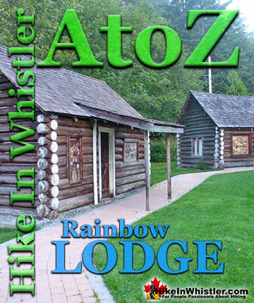
Rainbow Lodge was a popular wilderness lodge in the small community called Alta Lake, and what would eventually be called Whistler It was a fishing and ...
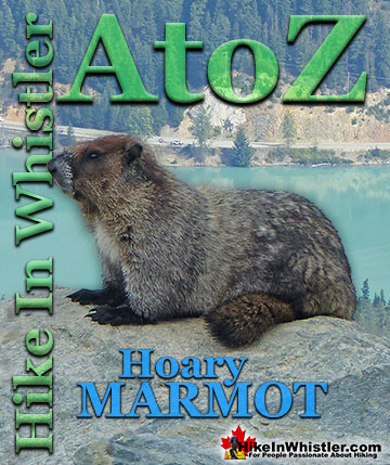
Hoary Marmots are the cute, pudgy, twenty plus pound ground squirrels that have evolved to live quite happily in the hostile alpine areas around Whistler. ...
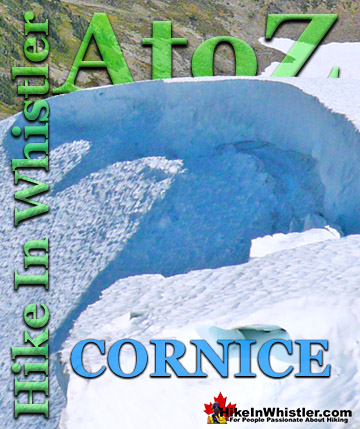
Cornice: a wind deposited wave of snow on a ridge, often overhanging a steep slope or cliff. They are the result of snow building up on the crest of a ...
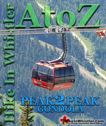
The Peak 2 Peak Gondola connects Whistler Mountain and Blackcomb Mountain at a dizzying height of 436 metres(1427 feet). It runs all winter and in the ...
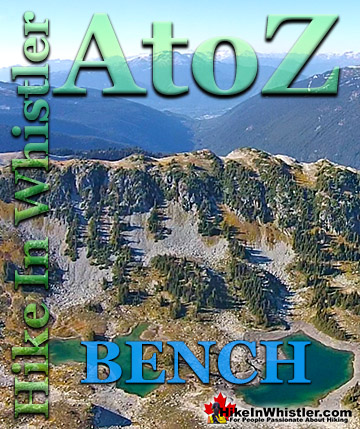
Bench: a flat section in steep terrain. Characteristically narrow, flat or gently sloping with steep or vertical slopes on either side. A bench can be ...
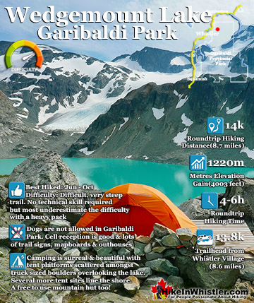
Wedgemount Lake itself is a magnificent destination for a day hike or spectacular overnight beneath the dazzling mountain peaks and stars above Garibaldi Provincial Park. Many sleep under the stars on one of ...
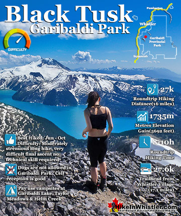
Black Tusk is the extraordinarily iconic and appropriately named mountain that can be seen from almost everywhere in Whistler. The massive black spire of crumbling rock juts out of the earth in an incredibly ...
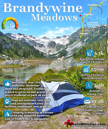
Brandywine Meadows is a nice, relatively short hike to a massive flower filled valley high up in Callaghan Valley. Located 40 minutes south of Whistler, this tough and sometimes muddy trail gains a huge 550 ...
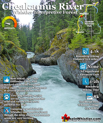
Cheakamus River is a beautiful, crashing, turquoise coloured river that flows from Cheakamus Lake, through Whistler Interpretive Forest, then down past Brandywine Falls to Daisy Lake, then all the way to ...
July is a wonderful time to hike in Whistler and Garibaldi Provincial Park. The weather is beautiful and the snow on high elevation hiking trails is long ...
August hiking in Whistler definitely has the most consistently great, hot weather. You can feel the rare pleasure of walking across a glacier shirtless and ...
September hiking in Whistler is possibly the best month of all. The snow has melted far up to the mountain tops, yet the temperatures are still quite ...
Hiking in Whistler in October is often unexpectedly stunning. The days are much shorter and colder but the mountains are alive with colour from the fall ...
Hiking in Whistler is spectacular and wonderfully varied. Looking at a map of Whistler you see an extraordinary spider web of hiking trails that are unbelievably numerous. Easy trails, moderate trails and challenging hiking trails are all available. Another marvellous ...
Squamish is located in the midst of a staggering array of amazing hiking trails. Garibaldi Provincial Park sprawls alongside Squamish and up and beyond Whistler. Tantalus Provincial Park lays across the valley to the west and the wonderfully remote Callaghan Valley ...
Vancouver is surrounded by seemingly endless hiking trails and mountains to explore. Massive parks line up one after another. Mount Seymour Provincial Park, Lynn Canyon Park, Grouse Mountain, Cypress Park and the enormous Garibaldi Park all contribute to Vancouver ...
Clayoquot Sound has a staggering array of hiking trails within it. Between Tofino and Ucluelet, Pacific Rim Park has several wilderness and beach trails, each one radically different from the last. The islands in the area are often Provincial parks on their own with ...
Victoria has a seemingly endless number of amazing hiking trails. Most take you to wild and beautiful Pacific Ocean views and others take you to tranquil lakes in beautiful BC Coastal Rainforest wilderness. Regional Parks and Provincial Parks are everywhere you turn ...
The West Coast Trail was created after decades of brutal and costly shipwrecks occurred along the West Coast of Vancouver Island. One shipwreck in particular was so horrific, tragic and unbelievable that it forced the creation of a trail along the coast, which ...