![]() Alexander Falls is a very impressive 43 metre/141 foot waterfall just 30 to 40 minutes south of Whistler in the Callaghan Valley. Open year-round and located just before Whistler Olympic Park where several of the 2010 Olympic events were held. There is a nice viewing platform on the edge of the cliff across from the falls which crash fantastically into the valley below.
Alexander Falls is a very impressive 43 metre/141 foot waterfall just 30 to 40 minutes south of Whistler in the Callaghan Valley. Open year-round and located just before Whistler Olympic Park where several of the 2010 Olympic events were held. There is a nice viewing platform on the edge of the cliff across from the falls which crash fantastically into the valley below.
 Very scenic drive to get there with bear sightings
- Impressively beautiful falls in the wilderness
- Amazing place for a picnic or glass of champagne
- Lots of other sights to see in the Callaghan Valley
- Effortless sightseeing as you drive to viewpoint
- Beautiful & free camping nearby
- Interesting history & information display
 Not much to see except the falls
- Camping is no longer allowed
- No visible connecting route to base of the falls
The parking area and viewing platform at Alexander Falls is one big area just 40 metres from the main road, just before Whistler Olympic Park. The adventurous can find the obscure trail that leads to both the top of the falls as well as, with great difficulty, to the base of the falls. Alexander Falls is certainly one of the nicest spots for a picnic in Whistler. The picnic areas are numerous, the surrounding forest is gorgeous and wild and Alexander Falls crashes loud and beautiful in the background. Several picnic tables are located in forested clearings that were once used as campsites, so if you have a big group, you will have lots of room to spread out and enjoy the surroundings. The free parking lot at Alexander Falls is enormous. Keep in mind that it is a day-use only parking area and camping or campfires are prohibited. If you are looking for a place to park overnight in the area the possibilities are endless. Callaghan Valley is very wild, devoid of people and the spider-web of logging roads that cover the valley run for hundreds of kilometres. Continued here...


More Sights Near Alexander Falls
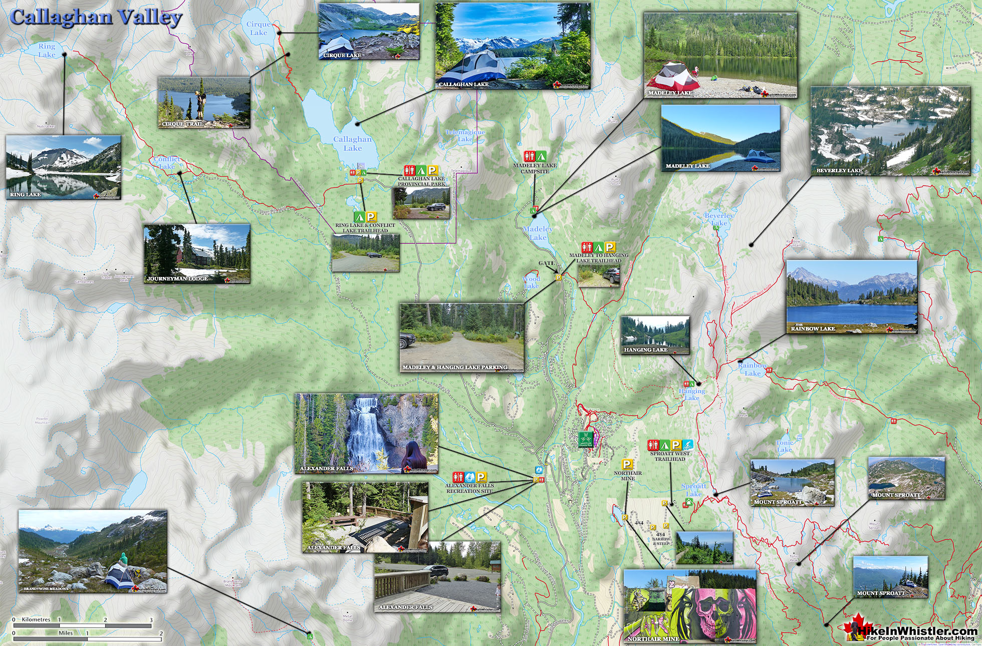
![]() The Callaghan Valley is home to some other great places to visit. Just past the Alexander Falls parking lot on your left you will see a sign for Callaghan Lake Provincial Park. If you turn left here you can either drive straight up a very bad logging road for 8.5 kilometres to Callaghan Lake. Callaghan Lake Provincial Park has only a couple short trails. There is, however, a the Cirque Lake trail at the end of the lake takes you to paradise! Cirque Lake is found high above Callaghan Lake and up quite a steep, but short 2 kilometre trail. Well worth the hike, but you have to have a canoe/kayak to get to the trailhead. If you want a quick look at a very pretty mountain lake, take the first right at the start of this logging road that takes you to Madeley Lake. On a sunny summer day, few places in Whistler are more serene and beautiful. A short trail from the end of the road, behind the lake takes you down to a lovely and sunny shore of this crystal clear lake. It is also a free campground that is very nice. Northair Mine is close by and a very interesting place to see, though you need a 4x4 to get up the increasingly deteriorating forest service road.
The Callaghan Valley is home to some other great places to visit. Just past the Alexander Falls parking lot on your left you will see a sign for Callaghan Lake Provincial Park. If you turn left here you can either drive straight up a very bad logging road for 8.5 kilometres to Callaghan Lake. Callaghan Lake Provincial Park has only a couple short trails. There is, however, a the Cirque Lake trail at the end of the lake takes you to paradise! Cirque Lake is found high above Callaghan Lake and up quite a steep, but short 2 kilometre trail. Well worth the hike, but you have to have a canoe/kayak to get to the trailhead. If you want a quick look at a very pretty mountain lake, take the first right at the start of this logging road that takes you to Madeley Lake. On a sunny summer day, few places in Whistler are more serene and beautiful. A short trail from the end of the road, behind the lake takes you down to a lovely and sunny shore of this crystal clear lake. It is also a free campground that is very nice. Northair Mine is close by and a very interesting place to see, though you need a 4x4 to get up the increasingly deteriorating forest service road.

Callaghan Lake Near Alexander Falls
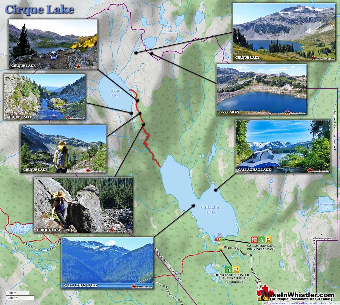
Callaghan Lake is a big and beautiful, remote lake high up beyond Alexander Falls. A free, drive-to campsite and parking area are located on one end of the lake and the rest of the lake is wild and untouched wilderness. There are few trails around the lake and most visitors travel by canoe, kayak or paddleboard. There is one significant trail to hike at the far end of Callaghan Lake and it is very nice. The somewhat hard to find trail starts at the far end of the lake and takes you up to a stunning glacier carved lake appropriately called Cirque Lake.

Cirque Lake Near Alexander Falls
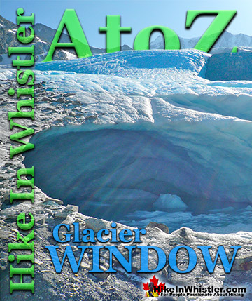
Cirque Lake gets its name from the term 'cirque', which is a glacier-carved bowl or amphitheatre in the mountains. To form, the glacier must be a combination of size, a certain slope and more unexpectedly, a certain angle away from the sun. In the northern hemisphere, this means the glacier must be on the northeast slope of the mountain, away from the suns rays and the prevailing winds. Thick snow, protected in this way, grows thicker into glacial ice, then a process of freeze-thaw called nivation, chews at the lower rocks, hollowing out a deep basin.

Madeley Lake Near Alexander Falls
Madeley Lake is a beautiful alpine lake just a 10 minute drive past Alexander Falls. A free, serene and hidden feeling campsite hides in the forest at the far end of the lake. Whistler Olympic Park has recently wrestled control over the access road and in 2020 and barricaded the access road. They attempted to require an access fee to the lake and quickly backtracked when they realized their quiet takeover of Madeley Lake would cause a public outcry and force the Resort Municipality of Whistler to coerce Whistler Olympic Park to return free access to the decades old regional park. The sign on the gate that stated "WARNING ENTERING WHISTLER OLYMPIC PARK CORE AREA YOU ARE REQUIRED TO HAVE A TICKET OR YOU ARE TRESPASSING" was quickly removed by WOP shortly after it was discovered by the public in 2020. They have since moved the gate much further up the road and it is now just one kilometre from the start of Madeley Lake and another kilometre to the end of the lake near the campsite.


Northair Mine Near Alexander Falls
Northair Mine is a strangely beautiful old goldmine near Alexander Falls. Abandoned several decades ago, the cement foundations are now adorned in colourful graffiti and stunning murals. In 2019 Kups, a professional Whistler muralist, painted a stunning mural across one of the largest and broadest cement walls. Along with the beautiful and surreal foundations, Northair Mine is also home to a surprisingly beautiful lake.

Alexander Falls Directions
![]() Cell coverage is reliable on the road and at the viewpoint to Alexander Falls so you will be able to access the internet if you have a data plan, however saving this map to your smartphone or tablet might be helpful. From Whistler Village: Drive south on Hwy 99(Sea to Sky Highway), 13.8 kilometres from Village Gate Boulevard, turn right onto Callaghan Valley Road at the sign to Whistler Olympic Park. Follow this road for 9.6 kilometres, keep an eye out on your left for a little sign that directs you to Alexander Falls. The sign/turnoff is just before Whistler Olympic Park.
Cell coverage is reliable on the road and at the viewpoint to Alexander Falls so you will be able to access the internet if you have a data plan, however saving this map to your smartphone or tablet might be helpful. From Whistler Village: Drive south on Hwy 99(Sea to Sky Highway), 13.8 kilometres from Village Gate Boulevard, turn right onto Callaghan Valley Road at the sign to Whistler Olympic Park. Follow this road for 9.6 kilometres, keep an eye out on your left for a little sign that directs you to Alexander Falls. The sign/turnoff is just before Whistler Olympic Park.

Alexander Falls Provincial Park Continued Here...
Guides to the Best of Whistler
 Best Dog Friendly Hiking Trails
Whistler is very dog friendly and the number of wonderful hiking trails that your dog will love is huge. The massively varied hiking trails range from easy, short, close to Whistler Village to challenging, long and deep in the endless wilderness around Whistler. You can find dog friendly trails in and around Whistler Village that take you through deep, dark and magical forests. Or you can drive beyond Whistler Village and take your dog to spectacular alpine lakes. Some requiring little or no hiking, while others are found after hiking challenging and long trails. Many of these places are comparatively quiet and often you and your dog will have the the wilderness to yourselves. In and around Whistler Village you have Lost Lake with its spider web of trails... Continued here.
 No Car? No Problem! Whistler Trails
Whistler as a resort has a wonderful car-free core. The Village Stroll runs through the heart of Whistler Village and is entirely car free. If you are visiting Whistler or living here and you don't have a car, it's no problem. On foot or on a bike you can travel the extensive network of non-motorized trails. The Valley Trail snakes through Whistler Village and extends in several directions, all of which lead to beautiful parts of Whistler. The Sea to Sky Trail and the Lost Lake trails continue this massive, car-free network of trails running almost everywhere in Whistler. When it comes to many of the best hiking trails, getting to the trailheads on foot, by bike or public transit can be tricky at best or complicated and impractical at worst. Many trailheads are far from Whistler Village and... Continued here.
 Kid Friendly Whistler Hiking Trails
There are plenty of excellent, kid and family friendly hiking trails and destinations in and around Whistler. Kid and family friendly generally means an easy and somewhat short trail that a toddler can happily manage. Some of these trails are flat enough to be stroller friendly, such as Brandywine Falls, Whistler Mountain and Blackcomb Mountain. Others such as Logger’s Lake, Cheakamus River and Madeley Lake have short enough trails to reach them that you can manage with little kids that don't want to hike too far. Some of these hikes and walks are popular and close to Whistler Village, like Whistler Mountain, Blackcomb Mountain, Lost Lake Park, Rainbow Park and Meadow Park. Others are a beautiful, but far drive into the mountains and tricky to find... Continued here.
 Whistler Train Wreck Murals
The colourful graffiti and murals that make Whistler Train Wreck the magical place it is today began appearing in 2011, when this hidden place was known by just a few Whistler locals. In the summer of 2011 several Whistler artists came here for "The Train Wreck Paint Jam" and transformed the mangled wreckage into a surreal art exhibit. The artists ranged from aspiring graffiti artists to professional artists like Kups. Remnants of one of his murals from 2011 is found inside the first boxcar you come to after crossing the bridge into Whistler Train Wreck. Several of the original murals were gorgeous. Brilliantly coloured and surreal in such an unusual, tranquil and hidden forest with seven mangled train boxcars scattered. Like some sort of haunting art gallery... Continued here.
 Northair Mine Murals
Way up in the Callaghan Valley on the back side of Mount Sproatt is an abandoned gold mine. Old cement foundations and two unexpectedly beautiful lakes mark the location of Northair Mine, abandoned in 1982. It was a fairly productive gold mine that extracted five tons of gold. Largely forgotten for years, in the last decade it has come to life in stunning colour by graffiti artists and professional muralists. In the summer of 2013, the first mural appeared on the blank foundation walls of Northair Mine. A creation of a professional Whistler artist PETKO. Painted on one of the inside, pillar walls, the mural is about 8 feet tall and five feet wide of what looks like a robot snake in front of a cube background. It stood out in striking contrast to the grey walls in the background... Continued here.
 Neal Carter Mountaineer
Neal Carter (14 Dec 1902 – 15 Mar 1978) was a mountaineer and early explorer of the Coast Mountains primarily in the 1920’s and 1930’s. Highly skilled as a mountaineer and climber, Carter also excelled at cartography and surveying which he used to map the vast unnamed and unexplored mountains of BC. He named a staggering number of mountains and alpine features, as well as making at least 25 first ascents, many around what we now call the Whistler Valley. Carter began climbing the mountains around Vancouver as a teenager and at the age of seventeen he met someone who would change his life forever. In 1920, while hiking with high school friends Carter had a chance encounter with Tom Fyles, arguably the greatest mountaineer of the era. Continued here.
More Whistler & Garibaldi Park Hiking Maps!
Ring Lake Maps
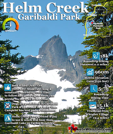
Helm Creek Maps
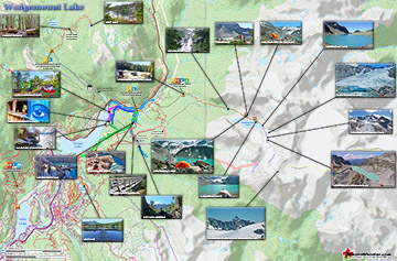
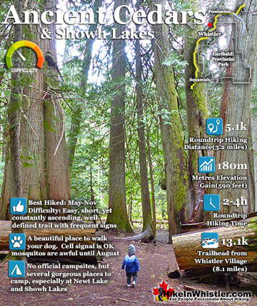
Wedgemount Lake Maps
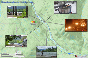
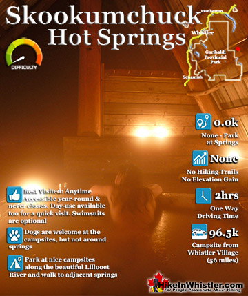
Skookumchuck Hot Springs Maps

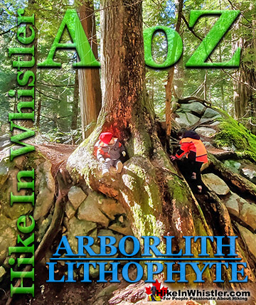
Whistler & Garibaldi Park Glossary A to Z

The Best Whistler & Garibaldi Park Hiking Trails!