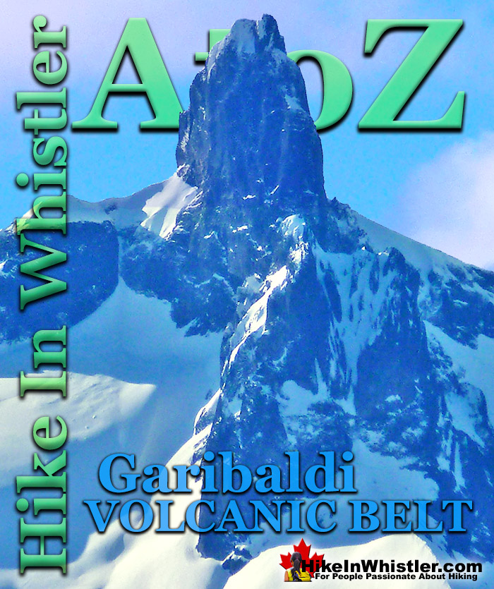
![]() The Garibaldi Volcanic Belt is a line of mostly dormant stratovolcanoes and subglacial volcanoes largely centred around Whistler and extending through much of the Coast Mountains. Divided into sections with the Mount Garibaldi Area at the southern end and the Mount Cayley area southwest of Whistler. The Mount Meager Area is west of Pemberton and the Bridge River Cones Area northwest of the Meager Area.
The Garibaldi Volcanic Belt is a line of mostly dormant stratovolcanoes and subglacial volcanoes largely centred around Whistler and extending through much of the Coast Mountains. Divided into sections with the Mount Garibaldi Area at the southern end and the Mount Cayley area southwest of Whistler. The Mount Meager Area is west of Pemberton and the Bridge River Cones Area northwest of the Meager Area.
Whistler & Garibaldi Hiking
![]() Alexander Falls
Alexander Falls ![]() Ancient Cedars
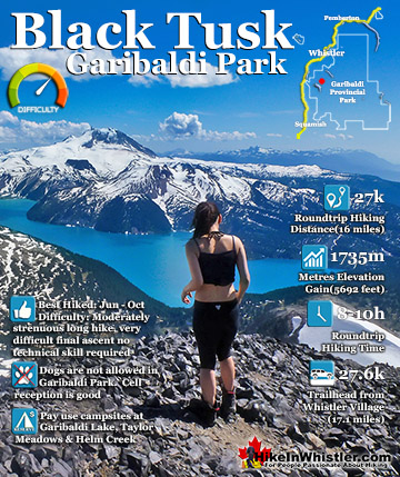
Ancient Cedars ![]() Black Tusk
Black Tusk ![]() Blackcomb Mountain
Blackcomb Mountain ![]() Brandywine Falls
Brandywine Falls ![]() Brandywine Meadows
Brandywine Meadows ![]() Brew Lake
Brew Lake ![]() Callaghan Lake
Callaghan Lake ![]() Cheakamus Lake
Cheakamus Lake ![]() Cheakamus River
Cheakamus River ![]() Cirque Lake
Cirque Lake ![]() Flank Trail
Flank Trail ![]() Garibaldi Lake
Garibaldi Lake ![]() Garibaldi Park
Garibaldi Park ![]() Helm Creek
Helm Creek ![]() Jane Lakes
Jane Lakes ![]() Joffre Lakes
Joffre Lakes ![]() Keyhole Hot Springs
Keyhole Hot Springs ![]() Logger’s Lake
Logger’s Lake ![]() Madeley Lake
Madeley Lake ![]() Meager Hot Springs
Meager Hot Springs ![]() Nairn Falls
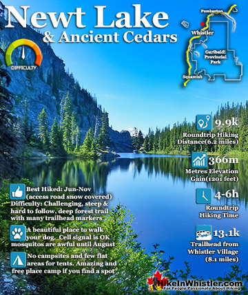
Nairn Falls ![]() Newt Lake
Newt Lake ![]() Panorama Ridge
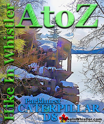
Panorama Ridge ![]() Parkhurst Ghost Town
Parkhurst Ghost Town ![]() Rainbow Falls
Rainbow Falls ![]() Rainbow Lake
Rainbow Lake ![]() Ring Lake
Ring Lake ![]() Russet Lake
Russet Lake ![]() Sea to Sky Trail
Sea to Sky Trail ![]() Skookumchuck Hot Springs
Skookumchuck Hot Springs ![]() Sloquet Hot Springs
Sloquet Hot Springs ![]() Sproatt East
Sproatt East ![]() Sproatt West
Sproatt West ![]() Taylor Meadows
Taylor Meadows ![]() Train Wreck
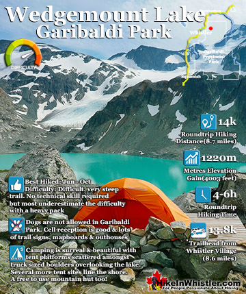
Train Wreck ![]() Wedgemount Lake
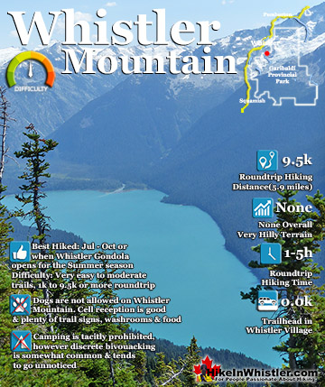
Wedgemount Lake ![]() Whistler Mountain
Whistler Mountain
![]() January
January ![]() February
February ![]() March
March ![]() April
April ![]() May
May ![]() June
June ![]() July
July ![]() August
August ![]() September
September ![]() October
October ![]() November
November ![]() December
December
And finally the Silverthrone Caldera Area which is a couple hundred kilometres northwest of Whistler. The Garibaldi Volcanic Belt makes up the northern section of the Cascade Volcanic Arc which includes Mount St. Helens, which had a major eruption in 1980. The Garibaldi Volcanic Belt is potentially active from several locations. Mount Garibaldi, Mount Price and many of the mountains in the area were tremendously active during the last ice age less than ten thousand year ago. Mount Price produced a lava flow that formed The Barrier and allowed Garibaldi Lake to form. Mount Meager had several massive eruptions in the last 2 million years, with the most recent one just 2360 years ago! This makes Mount Meager the most recent volcanic eruption in Canada. The Garibaldi Volcanic Belt is caused by the Juan de Fuca Plate and the North American Plate colliding together along the coast of British Columbia. The Juan de Fuca Plate is subducting under the North American Plate. It is estimated that these plates build up stress for centuries before slipping and producing a massive earthquake. The most recent mega-earthquake, the Cascadia earthquake occurred on January 26th, 1700. It is estimated that this megathrust earthquake ran from the centre of Vancouver Island down to northern California and produced a tsunami powerful enough to hit Japan. Similarly large earthquakes have occurred along this fault in 1310, 810, 400, 170BC and 600BC.
The Garibaldi Volcanic Belt was very active during the last major ice age and some interesting interactions took place between fire and ice. The Barrier at Garibaldi Lake was a lava flow that pushed against a massive glacier. The result of lava piling up against the wall of ice was the creation of The Barrier as well as filling the valley at one end, allowing Garibaldi Lake to form. The Barrier is comprised of unpredictably unstable rock that is dangerous enough to necessitate the evacuation of a small settlement at Rubble Creek a few decades ago. Rubble Creek is named from the rubble debris from The Barrier's last major collapse in 1856. Today it is the main trailhead for Garibaldi Provincial Park if you want to hike to Garibaldi Lake, Black Tusk and Panorama Ridge.


Garibaldi Volcanic Belt Southern Section
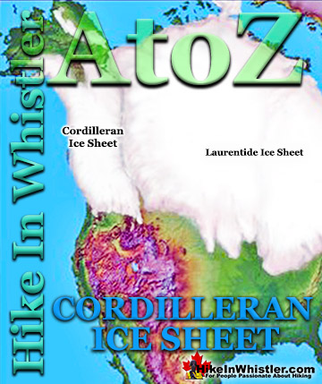
Mount Garibaldi was active in the last 300,000 years, with its most recent eruption just 9300 years ago. This eruption occurred during the last big ice age and lava erupted onto the Cordilleran Ice Sheet. Mount Garibaldi has had three detectable seismic events since 1985. Mount Price was a similarly active volcano during the same time Mount Garibaldi was, forming The Barrier and Garibaldi Lake. Cinder Cone lays on the north side of Garibaldi Lake and was quite active in the last 11,000 years. Lava flows from Cinder Cone down the valley along the flank of Black Tusk. Black Tusk is a stunning geological wonder formed in the last million years during two periods of volcanic activity. The original, much larger than today, volcano dome was eroded, exposing the roots of the cone. Further eruptions pushed against the surrounding glacier forming the distinctly tusk shaped pinnacle of black rock.


Garibaldi Volcanic Belt Central Section
The Mount Cayley Volcanic Field is another region of fairly recent volcanic activity. Mount Cayley began erupting about four million years ago and was active until just a couple hundred thousand years ago. Pali Dome, just north of Mount Cayley erupted several times in the last 25,000 years, and as recently as during the last ice age, 10,000 years ago. Nearby Cauldron Dome was similarly active during this period as well. Slag Hill, at the norther end of the Mount Cayley volcanic field appears to have been active less than 10,000 years ago. The Mount Cayley Volcanic Field has had four detectable seismic events since 1985. Ring Mountain appears to have been active as recently as the last ice age. Ring Lake is a nice hike in the Callaghan Valley with its trailhead just steps from the Callaghan Lake Provincial Park campsites and parking area. The Ring Lake trail ends at the lake with beautiful views across to Ring Mountain. A much quieter hiking trail than other Whistler and Garibaldi Park hiking trails. Callaghan Lake Provincial Park is a very beautiful mountain paradise with a pretty drivable access road that takes you right to the lake. Callaghan Lake and Cirque Lake are very beautiful and comparatively serene and untouched.


Garibaldi Volcanic Belt Northern Section
The northern segment of the Garibaldi Volcanic Belt has the Mount Meager massif. Mount Meager was the most recently active volcano in the Garibaldi Volcanic Belt. About 2350 years ago it had a major eruption with an ash column 20 kilometres high and spread ash as far as Alberta. Since 1985 the Mount Meager massif has had seventeen detectable seismic events. The Bridge River Cones are a series of stratovolcanoes, volcanic plugs and lava flows just a few kilometres north of the Meager massif. It appears that some of the lava flows in this area are less than 1500 year old. Further north, the Franklin Glacier complex and the Silverthrone Caldera are two large caldera complexes in the northern Garibaldi Volcanic Belt. Formed in the last million years, these two complexes have indications of volcanic activity as recently as 1000 years ago.


More Whistler & Garibaldi Park Hiking A to Z!

The Best Whistler & Garibaldi Park Hiking Trails!
Whistler & Garibaldi Park Best Hiking by Month!


Explore BC Hiking Destinations!

Whistler Hiking Trails

Squamish Hiking Trails

Vancouver Hiking Trails

Clayoquot Hiking Trails
Victoria Hiking Trails

