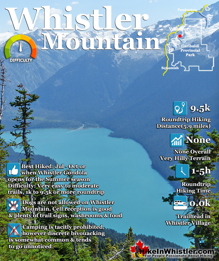
![]() The alpine hiking trails on Whistler Mountain are the ultimate in luxurious, quick-access alpine hiking. Little effort gets you amazing views of turquoise lakes, snowy mountains, valleys of flowers and distant glaciers. The Whistler Gondola takes you to the Roundhouse Lodge where you find gift shops, restaurants, viewing decks and the Umbrella Bar
The alpine hiking trails on Whistler Mountain are the ultimate in luxurious, quick-access alpine hiking. Little effort gets you amazing views of turquoise lakes, snowy mountains, valleys of flowers and distant glaciers. The Whistler Gondola takes you to the Roundhouse Lodge where you find gift shops, restaurants, viewing decks and the Umbrella Bar
 Endless alpine trails accessible by gondola
- Great way to access Garibaldi Park
- Best vantage point over Cheakamus Lake
- Effortless sightseeing from the lifts
- Great eating & drinking at the Roundhouse
- Wide range of easy to difficult hiking trails
- The Peak Chair is incredibly fun!
- Trails to Russet Lake in Garibaldi Park
- Peak2Peak Gondola to Blackcomb
 Pay access, but worth it!
Whistler & Garibaldi Hiking
![]() Alexander Falls
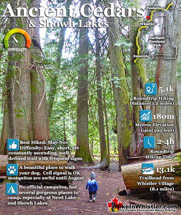
Alexander Falls ![]() Ancient Cedars
Ancient Cedars ![]() Black Tusk
Black Tusk ![]() Blackcomb Mountain
Blackcomb Mountain ![]() Brandywine Falls
Brandywine Falls ![]() Brandywine Meadows
Brandywine Meadows ![]() Brew Lake
Brew Lake ![]() Callaghan Lake
Callaghan Lake ![]() Cheakamus Lake
Cheakamus Lake ![]() Cheakamus River
Cheakamus River ![]() Cirque Lake
Cirque Lake ![]() Flank Trail
Flank Trail ![]() Garibaldi Lake
Garibaldi Lake ![]() Garibaldi Park
Garibaldi Park ![]() Helm Creek
Helm Creek ![]() Jane Lakes
Jane Lakes ![]() Joffre Lakes
Joffre Lakes ![]() Keyhole Hot Springs
Keyhole Hot Springs ![]() Logger’s Lake
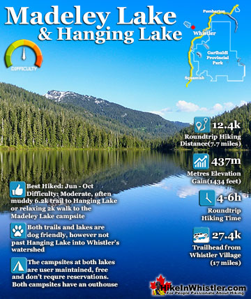
Logger’s Lake ![]() Madeley Lake
Madeley Lake ![]() Meager Hot Springs
Meager Hot Springs ![]() Nairn Falls
Nairn Falls ![]() Newt Lake
Newt Lake ![]() Panorama Ridge
Panorama Ridge ![]() Parkhurst Ghost Town
Parkhurst Ghost Town ![]() Rainbow Falls
Rainbow Falls ![]() Rainbow Lake
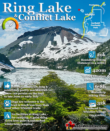
Rainbow Lake ![]() Ring Lake
Ring Lake ![]() Russet Lake
Russet Lake ![]() Sea to Sky Trail
Sea to Sky Trail ![]() Skookumchuck Hot Springs
Skookumchuck Hot Springs ![]() Sloquet Hot Springs
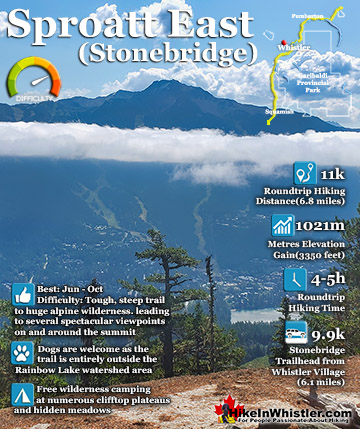
Sloquet Hot Springs ![]() Sproatt East
Sproatt East ![]() Sproatt West
Sproatt West ![]() Taylor Meadows
Taylor Meadows ![]() Train Wreck
Train Wreck ![]() Wedgemount Lake
Wedgemount Lake ![]() Whistler Mountain
Whistler Mountain
![]() January
January ![]() February
February ![]() March
March ![]() April
April ![]() May
May ![]() June
June ![]() July
July ![]() August
August ![]() September
September ![]() October
October ![]() November
November ![]() December
December
Just steps from the Roundhouse Lodge is one end of the Peak2Peak Gondola which takes you across to Blackcomb Mountain and another nice array of beautiful hiking trails. In the summer months, Whistler Mountain is somewhat divided in two. The lower half of the mountain is almost entirely for biking and the upper half is a spectacular combination of hardcore biking trails, hiking and sightseeing trails, as well as wonderful places to eat and drink.
There are three main directions you can hike from the Roundhouse Lodge. Just past the Peak2Peak Gondola building you will see the Spearhead Loop trail that is 1.2 kilometres or 0.7 miles long and with not a lot of elevation gain/loss at roughly 20 metres or 66 feet overall. Following it to the left you will descend down an easy trail toward Harmony Lake where you can link to the Harmony Lake Loop trail or veer back to where you started. If you follow the Spearhead Loop trail to the right you will quickly ascend a gravel road and after a couple hundred metres find the junction to Pika’s Traverse Road. This gravel access road takes you up to the summit of Whistler Mountain via a constantly ascending, though very beautiful 3.2 kilometre or 2 mile route. Up at this elevation, however, it is hard to not have a beautiful view. Most don’t take this route up as the Peak Express Chair takes you to Whistler’s summit. It may be your only way to get up to the summit if the Peak Express Chair is closed in the off-season or you have a baby or child that is not allowed to ride the Peak Chair. You do see plenty of people take this route down from the summit as it is very scenic, easy and home to the very picturesque Whistler ice walls. These huge walls of snow/ice that the access road cuts through are often 30 feet high or more. There is a height restriction measuring board on the trail to the Peak Express Chair. Kids must be over 1 metre or 40 inches tall to ride the Peak Express Chair and must be accompanied by an adult.
Whistler Mountain Musical Bumps Trail

Whistler Mountain Ice Walls Along Mathews' Traverse

Spearhead Loop Trail
![]() Back on the Spearhead Loop trail, if you continued along it and didn’t turn to follow Pika’s Traverse, you would have come to another trail veering off of it, the Harmony Meadows trail. The Harmony Meadows trail, aka the High Note trail, aka the Musical Bumps trail takes you through the beautiful valley running alongside Whistler Mountain. You can either loop back via the easier Harmony Lake Loop trail or continue the much longer trail past Symphony Lake, alongside Symphony Bowl and then the summit of Piccolo, one of the Musical Bumps. Here the trail splits with the Musical Bumps trail veering left toward Russet Lake and Singing Pass, or right continuing along the High Note trail back to the summit of Whistler Mountain.
Back on the Spearhead Loop trail, if you continued along it and didn’t turn to follow Pika’s Traverse, you would have come to another trail veering off of it, the Harmony Meadows trail. The Harmony Meadows trail, aka the High Note trail, aka the Musical Bumps trail takes you through the beautiful valley running alongside Whistler Mountain. You can either loop back via the easier Harmony Lake Loop trail or continue the much longer trail past Symphony Lake, alongside Symphony Bowl and then the summit of Piccolo, one of the Musical Bumps. Here the trail splits with the Musical Bumps trail veering left toward Russet Lake and Singing Pass, or right continuing along the High Note trail back to the summit of Whistler Mountain.
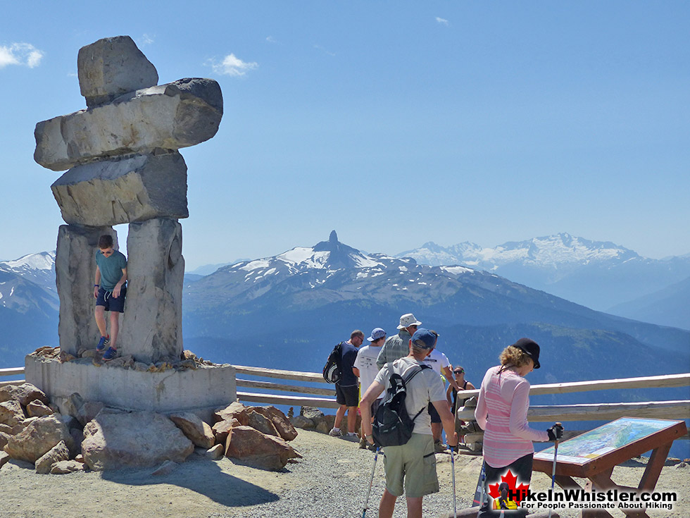
Whistler Mountain Summit Inukshuk and Black Tusk

Trails From the Roundhouse
![]() Back at the Roundhouse, the third direction you could have hiked is along the short, 5 minute(.6 kilometre or .4 mile) Peak Express Traverse trail to the Peak Express Chair. This very exhilarating ride to the summit of Whistler feels like a carnival ride as it carries you very high, very steep and pretty quickly to the top. From the summit of Whistler you will find o several hiking trails with a wide range of difficulty, but all pretty amazing. Along with the natural beauty of the alpine wilderness and the exquisitely coloured Cheakamus Lake in the valley below, you have some wonderful man-made attractions.
Back at the Roundhouse, the third direction you could have hiked is along the short, 5 minute(.6 kilometre or .4 mile) Peak Express Traverse trail to the Peak Express Chair. This very exhilarating ride to the summit of Whistler feels like a carnival ride as it carries you very high, very steep and pretty quickly to the top. From the summit of Whistler you will find o several hiking trails with a wide range of difficulty, but all pretty amazing. Along with the natural beauty of the alpine wilderness and the exquisitely coloured Cheakamus Lake in the valley below, you have some wonderful man-made attractions.
Whistler Mountain Peak Chair to the Summit

Cloudraker Skybridge on Whistler Mountain
In 2018 the Cloudraker Skybridge was built spanning the gap between cliffs just steps from the top of the Peak Express Chair. At 130 metres long and with Whistler Bowl directly below, the bridge sways as you walk across the dizzyingly high gap to the Raven's Eye. The Raven's Eye gives you wonderful views over the Whistler valley as well as an excellent vantage point to see the Peak Express Chair with Blackcomb Mountain and the Spearhead Range in the background. The Spearhead Range encompasses Blackcomb Mountain, while the Fitzsimmons Range includes Whistler Mountain and extends to Overlord Mountain. Overlord Mountain is where the two mountain ranges meet, separated by Fitzsimmons River that flows from Overlord Glacier down to Whistler Village before pouring into Green Lake. Fitzsimmons River gives Green Lake its wonderful glacier green colouring. Glacier water contains particles of rock that reflect light producing dazzlingly vivid colours. With Green Lake it is a brilliant light turquoise greenish colour, similar to Cheakamus Lake and Wedgemount Lake. Garibaldi Lake has more of a turquoise blue colour to it.
The Cloudraker Skybridge on Whistler Mountain

Trails From Whistler Peak
![]() At Whistler’s peak you can hike the cliffs adjacent to the top of the Peak Express Chair on the Whistler Mountain Summit Trail. This rugged, though very easy 1.6 kilometre set of trails can be done as a figure 8 loop trail. The large area to the right as you exit the Peak Express Chair with the inuksuk and the Cloudraker Skybridge & Raven's Eye is one side of the figure 8 and the other side ascends up past the Peak Express Chair to some incredible lookouts and interpretive information boards before bending back to meet Mathews’ Traverse, the gravel road that brings you back to where you started. Many follow Mathews’ Traverse down to the Roundhouse on a constantly descending and gorgeous 3.2 kilometre or 2 mile route past several stunning views and through the Whistler ice walls.
At Whistler’s peak you can hike the cliffs adjacent to the top of the Peak Express Chair on the Whistler Mountain Summit Trail. This rugged, though very easy 1.6 kilometre set of trails can be done as a figure 8 loop trail. The large area to the right as you exit the Peak Express Chair with the inuksuk and the Cloudraker Skybridge & Raven's Eye is one side of the figure 8 and the other side ascends up past the Peak Express Chair to some incredible lookouts and interpretive information boards before bending back to meet Mathews’ Traverse, the gravel road that brings you back to where you started. Many follow Mathews’ Traverse down to the Roundhouse on a constantly descending and gorgeous 3.2 kilometre or 2 mile route past several stunning views and through the Whistler ice walls.
Whistler Mountain Summit Trail

The Cloudraker Skybridge from the Peak Chair

Whistler Mountain Summit Trail
![]() The Whistler Mountain Summit Trail is quite easy and two much more challenging hiking trails can be found starting at the trailhead located next to the inuksuk just past the new Cloudraker Skybridge & Raven's Eye. The Half Note trail and the High Note trail both start here. The Half Note trail is a beautiful trail that follows the ridge of Whistler Mountain overlooking Cheakamus Lake. It bends back and connects to Pika’s Traverse Road which takes you back to the Roundhouse. This route is 5.5 kilometres or 3.4 miles and should take you 2 to 3 hours from the start at the top of the Peak Express Chair to the end at the Roundhouse. Alternatively you could take the much shorter Mathews’ Traverse Road(instead of Pika’s Traverse) back up to the summit of Whistler Mountain and ride the Peak Express Chair back down to the Roundhouse(via the short Peak Express Traverse trail). Where the Half Note trail veers back, the High Note trail continues. This much longer route takes you deeper into Garibaldi Provincial Park before meeting the junction to the Musical Bumps trail at Piccolo Summit. The High Note trail sinks into the valley in the shadow of Whistler Mountain and past Symphony Lake and Harmony Lake before reaching the Roundhouse. The High Note trail from the summit of Whistler Mountain at the Cloudraker Skybridge & Raven's Eye to the Roundhouse is 11 kilometres or 6.8 miles and takes most hikers 4-5 hours.
The Whistler Mountain Summit Trail is quite easy and two much more challenging hiking trails can be found starting at the trailhead located next to the inuksuk just past the new Cloudraker Skybridge & Raven's Eye. The Half Note trail and the High Note trail both start here. The Half Note trail is a beautiful trail that follows the ridge of Whistler Mountain overlooking Cheakamus Lake. It bends back and connects to Pika’s Traverse Road which takes you back to the Roundhouse. This route is 5.5 kilometres or 3.4 miles and should take you 2 to 3 hours from the start at the top of the Peak Express Chair to the end at the Roundhouse. Alternatively you could take the much shorter Mathews’ Traverse Road(instead of Pika’s Traverse) back up to the summit of Whistler Mountain and ride the Peak Express Chair back down to the Roundhouse(via the short Peak Express Traverse trail). Where the Half Note trail veers back, the High Note trail continues. This much longer route takes you deeper into Garibaldi Provincial Park before meeting the junction to the Musical Bumps trail at Piccolo Summit. The High Note trail sinks into the valley in the shadow of Whistler Mountain and past Symphony Lake and Harmony Lake before reaching the Roundhouse. The High Note trail from the summit of Whistler Mountain at the Cloudraker Skybridge & Raven's Eye to the Roundhouse is 11 kilometres or 6.8 miles and takes most hikers 4-5 hours.
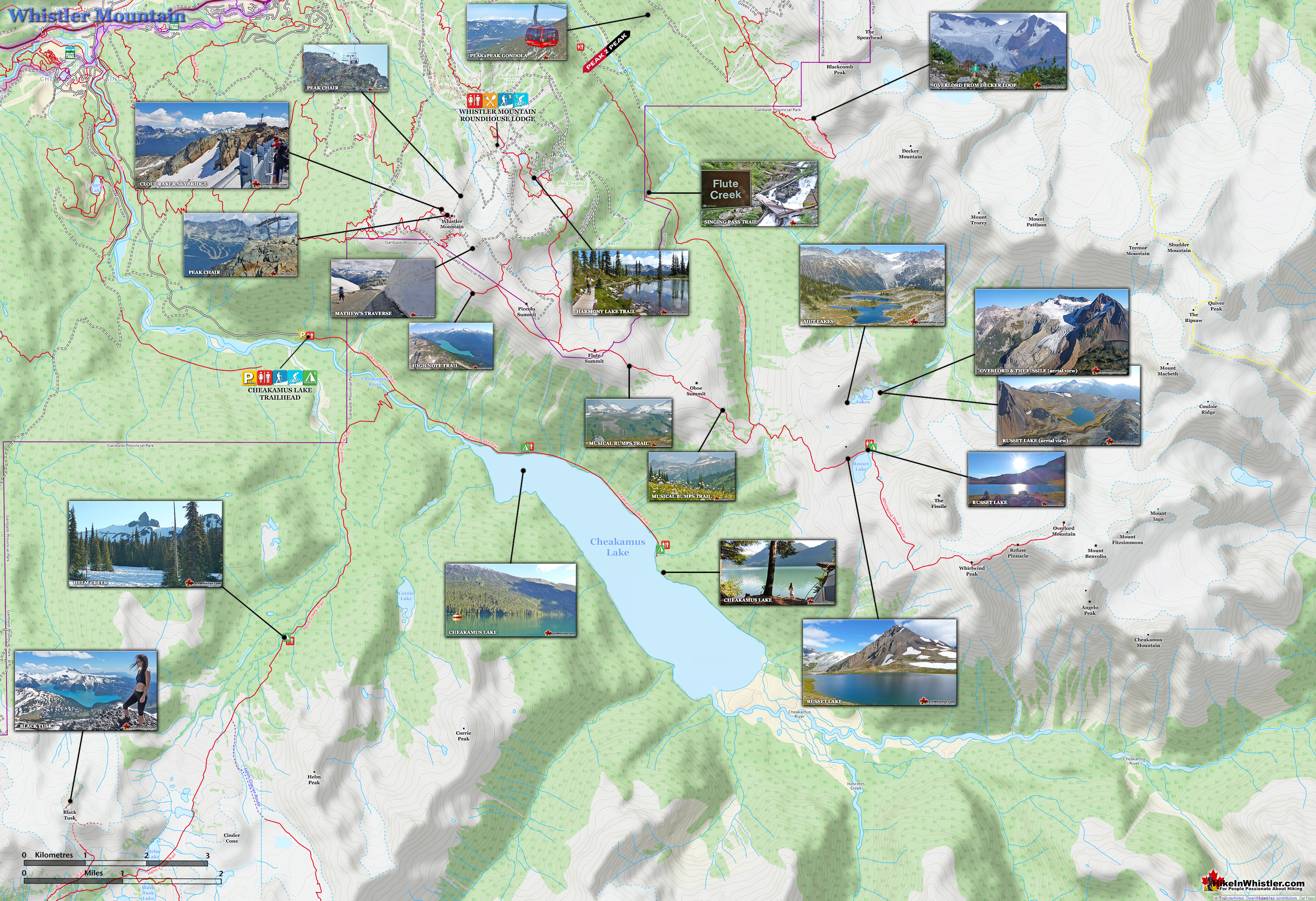
Whistler Mountain Hiking Trails Map
![]() Most start hiking the Whistler Mountain hiking trails at the Roundhouse at the terminus of the Whistler Gondola. You can also access Whistler Mountain for free by hiking the long Singing Pass trail and then across the Musical Bumps Trail to the peak of Whistler Mountain. The Singing Pass trail is long and boring as it runs a fairly direct line in between Whistler Mountain and Blackcomb Mountain, and always in deep forest. Years ago this 11.5 kilometre trail was much more enjoyable owing to the access road and parking area 4 kilometres up the trail. A slide took a chuck of the road out and years later you will still only find a ravine that you have to negotiate before continuing up to the original trailhead. Accessing Whistler Mountain with a day or season's pass is the best option for most. You ride in style up the Blackcomb Gondola then take the Peak2Peak Gondola across to Whistler Mountain where you arrive next to the Roundhouse Lodge. From the Roundhouse you can start hiking in a few directions or take the short walk down to the Peak Chair and ride up to the summit of Whistler Mountain. A pretty amazing way to start your hike.
Most start hiking the Whistler Mountain hiking trails at the Roundhouse at the terminus of the Whistler Gondola. You can also access Whistler Mountain for free by hiking the long Singing Pass trail and then across the Musical Bumps Trail to the peak of Whistler Mountain. The Singing Pass trail is long and boring as it runs a fairly direct line in between Whistler Mountain and Blackcomb Mountain, and always in deep forest. Years ago this 11.5 kilometre trail was much more enjoyable owing to the access road and parking area 4 kilometres up the trail. A slide took a chuck of the road out and years later you will still only find a ravine that you have to negotiate before continuing up to the original trailhead. Accessing Whistler Mountain with a day or season's pass is the best option for most. You ride in style up the Blackcomb Gondola then take the Peak2Peak Gondola across to Whistler Mountain where you arrive next to the Roundhouse Lodge. From the Roundhouse you can start hiking in a few directions or take the short walk down to the Peak Chair and ride up to the summit of Whistler Mountain. A pretty amazing way to start your hike.

Whistler Mountain Hiking Trails
![]() Whistler Mountain has a dozen named hiking trails that range from extremely easy and short to very challenging and long. All of them are pretty beautiful on their own, however all of them tend to be combined with others into routes, depending on what hikers are after and how much time and effort they want to put in. Another factor is the time of year and snowpack. In May and much of June, for example, you won’t have the Peak Express Chair running and almost every trail will be still buried in snow. If you are short on time and want to get to the obvious highlights, you will ride the Whistler Gondola to the Roundhouse Lodge, ride the Peak Express Chair to the summit of Whistler, see the Cloudraker Skybridge & Raven's Eye, inuksuk, Interpretive Walk, then ride back down to Whistler Village. If you are wanting more of a hike, you will not return via the Peak Express Chair, but instead hike the Half Note trail and check out the snow wall on Mathews’ Traverse. This route takes only a couple hours, but takes in a tremendous variety of sights and endless viewpoints.
Whistler Mountain has a dozen named hiking trails that range from extremely easy and short to very challenging and long. All of them are pretty beautiful on their own, however all of them tend to be combined with others into routes, depending on what hikers are after and how much time and effort they want to put in. Another factor is the time of year and snowpack. In May and much of June, for example, you won’t have the Peak Express Chair running and almost every trail will be still buried in snow. If you are short on time and want to get to the obvious highlights, you will ride the Whistler Gondola to the Roundhouse Lodge, ride the Peak Express Chair to the summit of Whistler, see the Cloudraker Skybridge & Raven's Eye, inuksuk, Interpretive Walk, then ride back down to Whistler Village. If you are wanting more of a hike, you will not return via the Peak Express Chair, but instead hike the Half Note trail and check out the snow wall on Mathews’ Traverse. This route takes only a couple hours, but takes in a tremendous variety of sights and endless viewpoints.
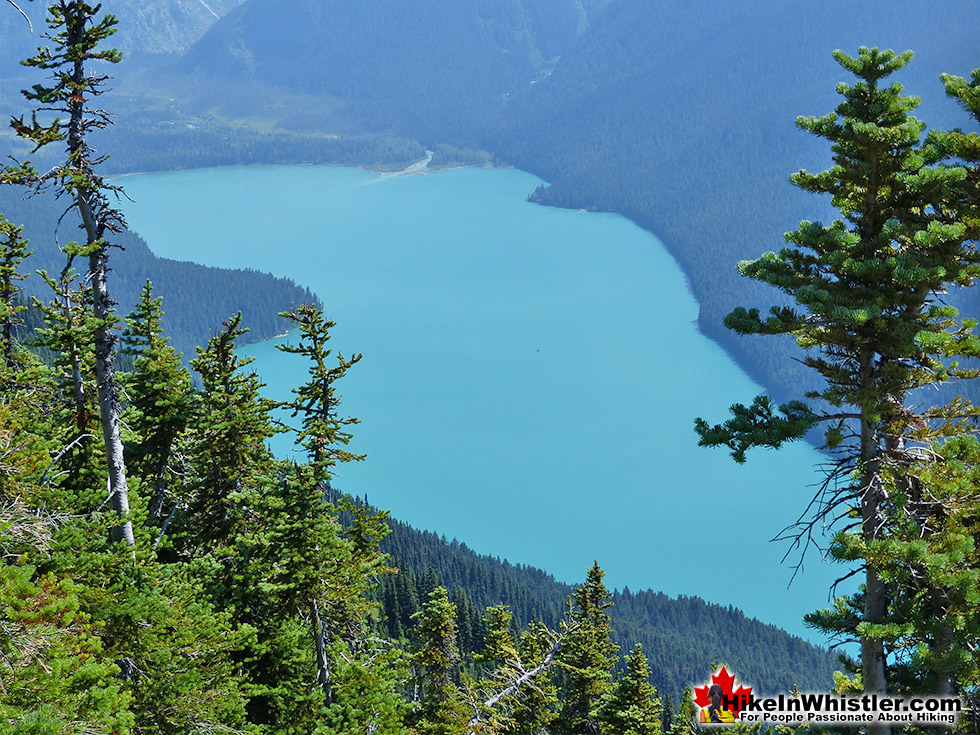
High Note Trail View of Cheakamus Lake

The High Note Trail
![]() For a more challenging and longer hike, the High Note trail is about a five hour trek that covers much of the Half Note trail and continues along the ridge toward the Musical Bumps. The trail then bends back through the beautifully lush, green valley in the shadow of Whistler Mountain, past lakes and through rocky terrain to arrive at the Roundhouse. If you are after a full day or overnight hike, then you can continue the High Note trail onto the Musical Bumps trail deep into Garibaldi Provincial Park. This trail takes you to Russet Lake, a hidden feeling lake in the midst of a pretty spectacular setting. At the foot of The Fissile, a stunning pyramid shaped, red mountain that Whistler Village was designed to allow for views of!
For a more challenging and longer hike, the High Note trail is about a five hour trek that covers much of the Half Note trail and continues along the ridge toward the Musical Bumps. The trail then bends back through the beautifully lush, green valley in the shadow of Whistler Mountain, past lakes and through rocky terrain to arrive at the Roundhouse. If you are after a full day or overnight hike, then you can continue the High Note trail onto the Musical Bumps trail deep into Garibaldi Provincial Park. This trail takes you to Russet Lake, a hidden feeling lake in the midst of a pretty spectacular setting. At the foot of The Fissile, a stunning pyramid shaped, red mountain that Whistler Village was designed to allow for views of!
The Fissile and Russet Lake

Village Gate's View of The Fissile
Village Gate Boulevard was oriented to have an unbroken view of this beautiful mountain as written in the original Whistler Village plans. Russet Lake overlooks Overlord Glacier, a hypnotically beautiful glacier to see, especially from so close! The glacier valley that Russet Lake sits in is interesting to hike in almost every direction. Down to the glacier, or up to The Fissile. There is even an unmarked route down to Cheakamus Lake to tempt adventurous and experienced hikers. Whistler Mountain is also home to the Singing Pass trail. The original route up the mountain that existed long before Whistler Mountain was called Whistler Mountain. The trailhead is located at the Whistler bus transit exchange in Whistler Village. This arduous trek takes you up the old trail along the valley between Whistler Mountain and Blackcomb Mountain along the Fitzsimmons River. Jimmy Fitzsimmons was the prospector that mined the area and had a small cabin near the Singing Pass trail and Musical Bumps trail junction.
Peak2Peak, Overlord and The Fissile

Hiking Trails Near Roundhouse Lodge
![]() The Spearhead Loop trail is a short, very easy, 1.2 kilometre or .7 mile loop trail that begins just past the Peak2Peak Gondola building. It descends down a gravel path to a snowmaking reservoir before looping back to where it started. The last section from the reservoir to the Peak2Peak Gondola building there are three trail junctions. The Harmony Lake Loop trail bends around the back of the reservoir and through a lovely alpine forest to Harmony Lake. Another trail junction at Harmony Lake goes left to another loop trail section of the Harmony Lake Loop trail or continues past the lake to yet another trail junction to the High Note trail and the Musical Bumps trail. Or you can take the trail to the right and follow the short, but challenging trail section of the Harmony Meadows trail back to the Spearhead Loop trail. The third Spearhead Loop trail junction, just before reaching the Peak2Peak Gondola building, is the wide gravel road hiking route, Pika’s Traverse. This long and continuously steep ascent takes you to the summit of Whistler Mountain along a very beautiful and constantly scenic route.
The Spearhead Loop trail is a short, very easy, 1.2 kilometre or .7 mile loop trail that begins just past the Peak2Peak Gondola building. It descends down a gravel path to a snowmaking reservoir before looping back to where it started. The last section from the reservoir to the Peak2Peak Gondola building there are three trail junctions. The Harmony Lake Loop trail bends around the back of the reservoir and through a lovely alpine forest to Harmony Lake. Another trail junction at Harmony Lake goes left to another loop trail section of the Harmony Lake Loop trail or continues past the lake to yet another trail junction to the High Note trail and the Musical Bumps trail. Or you can take the trail to the right and follow the short, but challenging trail section of the Harmony Meadows trail back to the Spearhead Loop trail. The third Spearhead Loop trail junction, just before reaching the Peak2Peak Gondola building, is the wide gravel road hiking route, Pika’s Traverse. This long and continuously steep ascent takes you to the summit of Whistler Mountain along a very beautiful and constantly scenic route.

The Harmony Lake Loop Trail
![]() The Harmony Lake Loop trail is another short, fairly easy loop trail, similar, to the Spearhead Loop trail, but deeper into the lush valley wilderness. A bit longer than the Spearhead Loop trail at 1.9 kilometres or 1.2 miles, the Harmony Lake Loop trail is a continuation of the Spearhead Loop trail and both trails together can be hiked from and back to the Roundhouse Lodge in an hour or two. The combined distance hiked is just over 3 kilometres or just under 2 miles. With fairly gradual elevation change overall, the Harmony Lake Loop trail and the Spearhead Loop trail are the only really good hiking option if you are with very young kids. There is a height/age restriction measuring board on the trail to the Peak Express Chair, so if you have kids under 5 years old, you may not meet this height requirement. Kids must be over 1 metre or 40 inches tall to ride the Peak Express Chair and must be accompanied by an adult. You can hike the beautiful Pika’s Traverse Road to the summit of Whistler, but it is quite a grueling trek for very young kids.
The Harmony Lake Loop trail is another short, fairly easy loop trail, similar, to the Spearhead Loop trail, but deeper into the lush valley wilderness. A bit longer than the Spearhead Loop trail at 1.9 kilometres or 1.2 miles, the Harmony Lake Loop trail is a continuation of the Spearhead Loop trail and both trails together can be hiked from and back to the Roundhouse Lodge in an hour or two. The combined distance hiked is just over 3 kilometres or just under 2 miles. With fairly gradual elevation change overall, the Harmony Lake Loop trail and the Spearhead Loop trail are the only really good hiking option if you are with very young kids. There is a height/age restriction measuring board on the trail to the Peak Express Chair, so if you have kids under 5 years old, you may not meet this height requirement. Kids must be over 1 metre or 40 inches tall to ride the Peak Express Chair and must be accompanied by an adult. You can hike the beautiful Pika’s Traverse Road to the summit of Whistler, but it is quite a grueling trek for very young kids.
Harmony Lake Loop Trail on Whistler Mountain

The Harmony Meadows Trail
![]() The Harmony Meadows trail runs parallel to the Harmony Lake Loop trail and is a fair bit tougher than the previous two trails here. It is a short trail, but very steep, winding and lots of loose rock to lose your footing on. With the steep elevation change, you get beautiful cliff views over the Harmony Lake Loop trail, and the massive valley that separates Whistler Mountain and Blackcomb Mountain. At 1.6 kilometres or 1 mile, the Harmony Meadows trail connects the High Note trail/Musical Bumps trail to the Harmony Lake Loop trail and/or the Spearhead Loop trail. If you have hiked this area before, you may notice the adjusting and renaming trail sections. The Harmony Meadows trail was previously part of the Musical Bumps trail, though it has been changed a bit and you will notice lots of zig-zags along the new route with "No Hiking" signs over the old, more direct sections. It appears that the new trail configuration is not much different than the old, slightly different route and seems to avoid a section that was buried in snow well into the summer.
The Harmony Meadows trail runs parallel to the Harmony Lake Loop trail and is a fair bit tougher than the previous two trails here. It is a short trail, but very steep, winding and lots of loose rock to lose your footing on. With the steep elevation change, you get beautiful cliff views over the Harmony Lake Loop trail, and the massive valley that separates Whistler Mountain and Blackcomb Mountain. At 1.6 kilometres or 1 mile, the Harmony Meadows trail connects the High Note trail/Musical Bumps trail to the Harmony Lake Loop trail and/or the Spearhead Loop trail. If you have hiked this area before, you may notice the adjusting and renaming trail sections. The Harmony Meadows trail was previously part of the Musical Bumps trail, though it has been changed a bit and you will notice lots of zig-zags along the new route with "No Hiking" signs over the old, more direct sections. It appears that the new trail configuration is not much different than the old, slightly different route and seems to avoid a section that was buried in snow well into the summer.
Following a Marmot on the Spearhead Loop Trail, Whistler Mountain

Navigating Whistler Mountain Trails
If this is all sounding a bit confusing, don’t worry, there are quite good signs at each trail junction indicating where everything is. There are the occasional mapboards to go with the very user friendly trail signs that point in the direction of each trail and even show the distance to the Roundhouse Lodge. You can easily just wander through these trails and decide at each junction where you want to go. All but a couple of the trails in this area return back to the Roundhouse Lodge. Keep in mind that all these trails, Harmony Lake Loop, Harmony Meadows and the Spearhead Loop trails are relatively easy due to their comparatively short hiking distances, however all have steep sections with loose rock. Baby strollers won't get far and if you are prone to losing your footing on irregular terrain, you should be aware. Having said that, all these trails are pretty kid friendly and short enough to keep them interested. The constantly zig-zagging, ascending and descending terrain is quite fun and very scenic. Also, nearly all hikers in the area head straight toward the summit of Whistler Mountain and even on extremely busy, summer days, these trails remain quiet and largely forgotten!
Whistler Summit Hiking Trails
There are two ways to get to the summit of Whistler Mountain, one easy and beautiful and the other tough and beautiful. Peak Express Traverse to the Peak Express Chair is easy and Pika’s Traverse Road and Mathews’ Traverse Road is a 3.2 kilometre or 2 mile, always ascending ascent to the summit. Pika’s Traverse and Mathews’ Traverse are actually access roads that work and supply vehicles get to the summit. Due to the stunning and constant views along the route have made these a popular hiking route over the years. The amazing ice walls along Mathews’ Traverse are a huge attraction as well. Though the Peak Express Chair is thrilling to ride up and down, as well as amazingly scenic, the traverse roads allow you to relax and soak in the scenery over the hour or so it takes you to hike.
Whistler Mountain Summit Trail
![]() The Whistler Summit Interpretive Walk is a gorgeous 1.6 kilometre or 1 mile route at the absolute summit of Whistler Mountain. Along the winding, rocky path you come across several very nice and informative information boards describing what you see and a bit of the history behind it. The hiking trail is a rough figure 8 in design, with the large area at the top of the Peak Express Chair with the inuksuk, Cloudraker Skybridge & Raven's Eye as one side. The other side of the figure 8 is where you find the interesting interpretive boards. Because most visitors to the summit of Whistler Mountain immediately head to the Cloudraker Skybridge & Raven's Eye and the inuksuk, the rest of the Summit Interpretive Walk remains relatively quiet. If you are lucky you will have the far viewpoint to yourself. It juts way out overlooking Glacier Bowl, a massive valley of snow and ice with the enormous Whistler Valley stretching out to an endless wall of mountains. From this spot you can get a good look at Blackcomb Mountain and the Spearhead Range. Lost Lake, Green Lake and Alta Lake are easily spotted with such a great vantage point. Further along the trail you come to another endless mountain view and more info boards with descriptions of the mountains you see. Black Tusk is explained as a conventional volcano that had its outer cone ripped away by glaciers about 170,000 years ago. From this viewpoint you can readily see how it once looked like and how the current, narrow black shape is the solidified lava from its central vent. The murals also describe the massive glaciers that filled and, in some cases covered many of the mountains in the Coast Mountains. The summit of Whistler was for a short time covered by a glacier. Further mountain descriptions include Mount Cayley, a potentially active volcano that geologists keep a close eye on.
The Whistler Summit Interpretive Walk is a gorgeous 1.6 kilometre or 1 mile route at the absolute summit of Whistler Mountain. Along the winding, rocky path you come across several very nice and informative information boards describing what you see and a bit of the history behind it. The hiking trail is a rough figure 8 in design, with the large area at the top of the Peak Express Chair with the inuksuk, Cloudraker Skybridge & Raven's Eye as one side. The other side of the figure 8 is where you find the interesting interpretive boards. Because most visitors to the summit of Whistler Mountain immediately head to the Cloudraker Skybridge & Raven's Eye and the inuksuk, the rest of the Summit Interpretive Walk remains relatively quiet. If you are lucky you will have the far viewpoint to yourself. It juts way out overlooking Glacier Bowl, a massive valley of snow and ice with the enormous Whistler Valley stretching out to an endless wall of mountains. From this spot you can get a good look at Blackcomb Mountain and the Spearhead Range. Lost Lake, Green Lake and Alta Lake are easily spotted with such a great vantage point. Further along the trail you come to another endless mountain view and more info boards with descriptions of the mountains you see. Black Tusk is explained as a conventional volcano that had its outer cone ripped away by glaciers about 170,000 years ago. From this viewpoint you can readily see how it once looked like and how the current, narrow black shape is the solidified lava from its central vent. The murals also describe the massive glaciers that filled and, in some cases covered many of the mountains in the Coast Mountains. The summit of Whistler was for a short time covered by a glacier. Further mountain descriptions include Mount Cayley, a potentially active volcano that geologists keep a close eye on.
View from the Whistler Mountain Summit Trail

Overlord From the Whistler Mountain Summit Trail

Mathews’ Traverse & Pika’s Traverse
![]() Mathews’ Traverse & Pika’s Traverse are two connected access roads/hiking routes that connect the Roundhouse Lodge to the summit of Whistler Mountain. Both have almost constantly amazing views of Whistler valley, the Spearhead Range, Black Tusk, Musical Bumps and quite a lot more. The combined length of both roads between the summit of Whistler and the Roundhouse is 3.2 kilometres or 2 miles. With an elevation change of 354 metres or 1161 feet, hiking up is pretty arduous, though hiking down is very pleasant. Many hikers hike it down from the summit in order to see the marvellous ice walls along Mathews’ Traverse.
Mathews’ Traverse & Pika’s Traverse are two connected access roads/hiking routes that connect the Roundhouse Lodge to the summit of Whistler Mountain. Both have almost constantly amazing views of Whistler valley, the Spearhead Range, Black Tusk, Musical Bumps and quite a lot more. The combined length of both roads between the summit of Whistler and the Roundhouse is 3.2 kilometres or 2 miles. With an elevation change of 354 metres or 1161 feet, hiking up is pretty arduous, though hiking down is very pleasant. Many hikers hike it down from the summit in order to see the marvellous ice walls along Mathews’ Traverse.
Mathews' Traverse Snow Walls on Whistler Mountain

Hiking Time to Whistler Peak
Expect to take a bit less than an hour to hike down from the summit of Whistler to the Roundhouse. Hiking up takes most people an hour at a fast pace or over an hour at a slower pace. Because small children cannot ride the Peak Express Chair, hiking up is the only option for many. There is a sign at the start of the short hike to the Peak Express Chair with a bear standing, indicating you have to be this tall(1 metre) to ride the Peak Chair. Kids under 4 years old will likely not make the height restriction. Another reason hikers may need to hike up Mathews’ and Pika’s Traverse is when the Peak Express Chair is not running. Stormy, windy days, mechanical problems and early summer and late summer are times when the Peak Express Chair is unavailable to access the summit of Whistler.
Pika's Traverse View of Whistler Valley

High Note & Half Note Trails
![]() The High Note trail begins high up on Whistler Mountain at the top of the Peak Express chairlift. To get there you must buy a lift pass and ride the Whistler Gondola for 22 minutes up to the Roundhouse Lodge on Whistler Mountain, then hike for about 8 minutes to the Peak Express. Ride this beautiful and alarmingly steep chairlift up to Whistler's Peak where the High Note trail begins. The new Cloudraker Skybridge & Raven's Eye Walk is near the gateway to the High Note Trail, which is located next to the inuksuk. Of all the hiking choices on Whistler Mountain and Blackcomb Mountain, the High Note trail is possibly the most amazing and scenic. It has several attributes that make it a must-do hike on any summer visit to Whistler. First, the fact that it effectively starts and finishes at the Roundhouse Lodge is fantastic. The Roundhouse Lodge has a very nice and reasonably priced restaurant with an outdoor seating area with million-dollar views all around. They also have a great selection of pub style drinks so you can toast a beer or glass of wine on top of the world at the new Umbrella Bar after, or before your hike.
The High Note trail begins high up on Whistler Mountain at the top of the Peak Express chairlift. To get there you must buy a lift pass and ride the Whistler Gondola for 22 minutes up to the Roundhouse Lodge on Whistler Mountain, then hike for about 8 minutes to the Peak Express. Ride this beautiful and alarmingly steep chairlift up to Whistler's Peak where the High Note trail begins. The new Cloudraker Skybridge & Raven's Eye Walk is near the gateway to the High Note Trail, which is located next to the inuksuk. Of all the hiking choices on Whistler Mountain and Blackcomb Mountain, the High Note trail is possibly the most amazing and scenic. It has several attributes that make it a must-do hike on any summer visit to Whistler. First, the fact that it effectively starts and finishes at the Roundhouse Lodge is fantastic. The Roundhouse Lodge has a very nice and reasonably priced restaurant with an outdoor seating area with million-dollar views all around. They also have a great selection of pub style drinks so you can toast a beer or glass of wine on top of the world at the new Umbrella Bar after, or before your hike.
The Roundhouse Lodge on Whistler Mountain

Amazing Peak Chair
Second, after the Roundhouse Lodge there is a short hike to the carnival like, Peak Express Chair, which takes you to the High Note trailhead. This ride alone will cause you to snap about 25 photos as you ride into the clouds to the summit of Whistler Mountain. And the third and most beautiful aspect of the High Note trail is that half of it runs along the edge of Whistler Mountain with the hypnotically beautiful Cheakamus Lake always in view. This lake has that surreal and certainly bizarre looking colour that never quite looks real. With the sun shining off of it, producing such a vibrant blue that contrasts the green of everything else around you.
The Amazing Peak Chair to the Summit of Whistler Mountain

High Note Trail From Whistler Peak
High Note trail begins with some narrow, rocky and fairly steep ups and downs as you hike out to the edge of a rock outcrop with your first trail views of the valley and Whistler below. Though there are two small chain-assist sections, most hikers should have no difficulty in this section. Even if you are bringing your kids along, you will have no problem or worry at these parts or any other along the trail. After this short up and down section at the beginning of the High Note trail, the route evens out and runs along the edge of the ridge parallel to the amazing Cheakamus Lake far down the valley below. The entire ridge that runs parallel to Cheakamus Lake is in Garibaldi Provincial Park and all you see for hundreds of kilometres is untouched wilderness.
The High Note Trail and Cheakamus Lake

High Note Trail Signs
There are signs at a couple spots along the way directing you very clearly. The High Note trail is 9.4 kilometres/5.8 miles long and takes about 3-4 hours to hike one way. Before you reach the Roundhouse Lodge the High Note trail connects to the Harmony Lake trail or the Harmony Meadows trail which adds another 20-30 minutes of hiking time to your journey. Partway along the trail you can take a short cut, the Half Note Trail and head back earlier and shorten the trail by a couple kilometres. The trail is by no means easy as it is narrow and has a few ups and downs, but aside from the fairly long distance (9.4k), the High Note Trail is family friendly.
The High Note Trail on Whistler Mountain

Whistler Mountain Trails Open
It is free of snow from late June to October and easily accessible depending on when the Whistler Gondola and Peak Express are open of course. The cost to access Whistler Mountain is about $160 for a summer lift pass, however, there is so much to see and do up there, not least the Peak2Peak Gondola which shouldn't be missed on the same outing as hiking the High Note trail. One common misconception about paying to go up Whistler Mountain in the summer is that you will only be up there for an hour or so as there is little to do. The opposite is actually the case. If you hike the High Note trail, stop in at the Roundhouse Lodge, cross over to Blackcomb Mountain on the Peak2Peak Gondola, and then ride back down to Whistler Village, you may take well over 5 hours and have an amazing time.
The Musical Bumps Trail on Whistler Mountain
![]() Not too many years ago, before hiking trails were constructed from the summit of Whistler Mountain, the Musical Bumps trail was the only hiking trail on Whistler. It began at the Roundhouse Lodge and stretched across to the current Musical Bumps trail and to the Singing Pass trail. The Singing Pass trail is the original hiking trail to access Whistler Mountain and has existed long before Whistler Mountain was called Whistler Mountain. The High Note trail now runs from the summit of Whistler Mountain along the ridge that connects to the series of summits known as the Musical Bumps. Piccolo is the first summit and where the High Note trail bends back towards the Roundhouse Lodge and the Musical Bumps trail continues on to the next summit, Flute. Then finally Oboe, before descending to the Singing Pass trail back to Whistler Village or up to Russet Lake in Garibaldi Park.
Not too many years ago, before hiking trails were constructed from the summit of Whistler Mountain, the Musical Bumps trail was the only hiking trail on Whistler. It began at the Roundhouse Lodge and stretched across to the current Musical Bumps trail and to the Singing Pass trail. The Singing Pass trail is the original hiking trail to access Whistler Mountain and has existed long before Whistler Mountain was called Whistler Mountain. The High Note trail now runs from the summit of Whistler Mountain along the ridge that connects to the series of summits known as the Musical Bumps. Piccolo is the first summit and where the High Note trail bends back towards the Roundhouse Lodge and the Musical Bumps trail continues on to the next summit, Flute. Then finally Oboe, before descending to the Singing Pass trail back to Whistler Village or up to Russet Lake in Garibaldi Park.
The Beautiful Musical Bumps Trail on Whistler Mountain

High Note and Musical Bumps
The Section of the High Note trail that extends from the Musical Bumps trail to the Roundhouse Lodge was previously called the Musical Bumps trail and to most locals still is. If you are hiking to Russet Lake with the Roundhouse as your starting point, you have two trail choices. The old Musical Bumps trail, now separated into smaller sections with their own names. The Spearhead Loop Trail to either the Harmony Meadows trail or the Harmony Lake Loop trail, which both connect to the High Note trail, which leads to the Musical Bumps trail. Taking the Musical Bumps trail with your starting point at the Roundhouse Lodge on Whistler Mountain is arguably the best route to Russet Lake. It is fairly direct at 12.5 kilometres to Russet Lake and full of incredible views. Alpine forests, massive valleys, small alpine lakes, dramatic mountain views all around. The trail has considerable elevation gain and loss though. The trail is well marked with signs directing you along the Musical Bumps trail. You won't see Russet Lake signs until you reach the trail junction at the Singing Pass trail. This route is a very popular trail running route in Whistler. From the Roundhouse Lodge to the Village is 24 kilometres, and much of it downhill.
Flute Summit Along the Musical Bumps Trail

The Original Musical Bumps Trail
To find this original Musical Bumps route to Russet Lake take the Whistler Gondola up to the Roundhouse Lodge, walk past the Peak2Peak Gondola building, up a gravel slope about 50 metres. On your left you will see a trailhead. Trail names have been evolving over the recent years and keep in mind that you may not see any mention of Russet Lake, Singing Pass Trail, or even the Musical Bumps trail until you get a couple kilometres into the trail. From the Roundhouse Lodge, look for the trail marked as Harmony Lake trail and follow it to the High Note trail. Once on the High Note trail you will soon see signs indicating the Musical Bumps trail and the Singing Pass trail. The High Note trail hits a junction where the Musical Bumps trail veers left while the High Note trail bends right back toward the summit of Whistler Mountain. Once on the Musical Bumps trail you will soon reach Flute Summit. At Flute Summit follow the signs to Singing Pass. The signs on this route are sometimes confusing as some get destroyed during the winter. Just be sure to aim for Flute Summit, then Singing Pass, then Russet Lake. From Russet Lake, you can return to Whistler Village the way you came, or via the High Note trail, or via the Singing Pass trail, which brings you back to Whistler Village.

History of Whistler Mountain
![]() Whistler Mountain a century ago was inhabited by just a couple prospectors. Most notably Jimmy Fitzsimmons, who lived in a prospector cabin and created the Avalanche Pass trail. Later renamed the Singing Pass trail, it is still in use today as one of five main trailhead access points to Garibaldi Provincial Park. In September 1923 two Vancouver area mountaineers, set out from the Rainbow Lodge to explore the vast and largely unexplored wilderness beyond the Avalanche Pass trail. Neal Carter and Charles Townsend explored The Fissile(Red Mountain at the time), Overlord Mountain and many more. The claimed the first ascent of several mountains in the area, including Wedge Mountain, James Turner and many more. Neal Carter went on to map the area in detail and successfully lobbied the Provincial Government to expand the boundary of the newly created Garibaldi Park to include the Spearhead Range and the series of mountains, glaciers and valleys stretching almost to Pemberton.
Whistler Mountain a century ago was inhabited by just a couple prospectors. Most notably Jimmy Fitzsimmons, who lived in a prospector cabin and created the Avalanche Pass trail. Later renamed the Singing Pass trail, it is still in use today as one of five main trailhead access points to Garibaldi Provincial Park. In September 1923 two Vancouver area mountaineers, set out from the Rainbow Lodge to explore the vast and largely unexplored wilderness beyond the Avalanche Pass trail. Neal Carter and Charles Townsend explored The Fissile(Red Mountain at the time), Overlord Mountain and many more. The claimed the first ascent of several mountains in the area, including Wedge Mountain, James Turner and many more. Neal Carter went on to map the area in detail and successfully lobbied the Provincial Government to expand the boundary of the newly created Garibaldi Park to include the Spearhead Range and the series of mountains, glaciers and valleys stretching almost to Pemberton.

London Mountain
Whistler Mountain was originally called London Mountain after a mining claim more than a century ago. The settlement that preceded the town of Whistler was called Alta Lake after the fishing lodge that was built in 1914, shortly after the railway line was completed. The Rainbow Lodge existed on the shores of Alta Lake until 1977. Today at Rainbow Park you will find several small log cabins and a replica of the original bridge over the River of Golden Dreams as well as several large murals of the old Rainbow Lodge and the characters that pioneered the area before it became Whistler. In 1966 Whistler Mountain was opened as a ski resort, though it wasn’t until 1976 that the town of Alta Lake was rebranded as Whistler. The renaming of London Mountain to Whistler Mountain had a couple reasons. Locals had called the mountain Whistler Mountain for decades due to the whistling sound of the resident hoary marmots in the area. So, it was known as London Mountain on maps and Whistler Mountain locally. Also, in branding the new ski resort the name London Mountain was thought to bring to mind the notoriously bad weather of London, England.
Geology of Whistler Mountain
![]() The Fitzsimmons Range is a subsection of the Garibaldi Ranges that covers the area between the valleys of Cheakamus Lake and Fitzsimmons Creek. Fitzsimmons Creek cuts between Whistler Mountain and Blackcomb Mountain and largely originates from the Fitzsimmons Glacier. The Fitzsimmons Glacier and Mount Fitzsimmons are part of the Overlord Massif, which gets its name from the highest peak in the area, Overlord Mountain. Massif is a term used in geology to refer to a compact group of connected mountains that easily identify into one large mountain mass. Massif is a French word that means “massive”. The Fitzsimmons Range includes several locally famous summits, including the summit of Whistler, Oboe Summit, Piccolo Summit and Flute Summit. These form the Musical Bumps trail which is a gorgeous route to the Russet Lake campground in Garibaldi Provincial Park. Next to Russet Lake is The Fissile and next to The Fissile is Overlord Mountain. Near Russet Lake and connecting to the Musical Bumps trail is the Singing Pass trail that ascends along Fitzsimmons Creek to Whistler Village at the base of Whistler Mountain.
The Fitzsimmons Range is a subsection of the Garibaldi Ranges that covers the area between the valleys of Cheakamus Lake and Fitzsimmons Creek. Fitzsimmons Creek cuts between Whistler Mountain and Blackcomb Mountain and largely originates from the Fitzsimmons Glacier. The Fitzsimmons Glacier and Mount Fitzsimmons are part of the Overlord Massif, which gets its name from the highest peak in the area, Overlord Mountain. Massif is a term used in geology to refer to a compact group of connected mountains that easily identify into one large mountain mass. Massif is a French word that means “massive”. The Fitzsimmons Range includes several locally famous summits, including the summit of Whistler, Oboe Summit, Piccolo Summit and Flute Summit. These form the Musical Bumps trail which is a gorgeous route to the Russet Lake campground in Garibaldi Provincial Park. Next to Russet Lake is The Fissile and next to The Fissile is Overlord Mountain. Near Russet Lake and connecting to the Musical Bumps trail is the Singing Pass trail that ascends along Fitzsimmons Creek to Whistler Village at the base of Whistler Mountain.
Overlord Glacier, Overlord Mountain and The Fissile

The Fissile
The Fissile is the stunning Matterhorn looking mountain that is visible from Village Gate Boulevard in Whistler. Looking up from Village Gate you will see the distant Peak2Peak Gondola spanning Whistler Mountain and Blackcomb Mountain. In the background distance you will see The Fissile. In the bright sunshine of summer it will be vibrantly coloured red. In the evening it turns dark red then fades into an ominous black. In the winter months, of course, The Fissile is a striking, white pyramid. For newcomers to Whistler, The Fissile can go unnoticed for weeks, or even months. Until you find yourself at one of the many perfect vantage points to this beautiful mountain peak, such as Village Gate Boulevard. One little known fact about Whistler is how intricately designed The Village is. The Village Gate entrance to Whistler Village was designed in the late 70’s with one thing in mind. It had to have a view of The Fissile.
The Fissile and the Peak2Peak Gondola

Originally called Red Mountain, it wasn’t until 1965 the name was changed to The Fissile. One motivation may have been the fact that Red Mountain is a very common mountain name. Two local Whistler legends, Karl Ricker and Neal Carter suggested the name. Karl Ricker was mountaineering legend that, along with Bert Port, Chris Gardner and Alistair MacDonald that skied and mapped out the Spearhead Traverse in 1964. Neal Carter was also a mountaineering legend was the first to explore many Whistler area mountains in the 1920’s and 1930’s. Photographing and documenting many first ascents of Whistler area mountains like Wedge Mountain and Mount James Turner. The name The Fissile is derived from the geological term fissility. Fissility refers to the tendency of certain rocks to split along flat planes of weakness. Sedimentary rocks like shale and slate to develop planes of weakness along layers during compaction. The Fissile is a mountain of red slate and a remarkably beautiful example of a mountain showing fissility.

The Fissile is quite a distinct mountain in Garibaldi Park because of its vivid red colour and symmetrical arrowhead shape. There is another, even more remarkable feature of The Fissile, its age. The sedimentary rock that would eventually become The Fissile was laid down more than 200 million years ago. The Fissile began its life as sedimentary rock formed in a shallow sea along the coast of North America. As tectonic plates pushed into the North American Plate from the Pacific, the Coast Mountains we formed over millions of years. The Coast Mountains are almost entirely comprised of geologically young mountains comprised of volcanic rock. Black Tusk, for example is strikingly youthful at just over a million years old.
Camping & Bivouacking - Whistler Mountain
![]()
![]() Whistler Mountain is generally for day-hiking and there are no facilities for camping. Though you don’t see signs prohibiting camping anywhere, there is no camping allowed within the Whistler Resort areas of Whistler Mountain. Garibaldi Provincial Park surrounds Whistler Mountain and the border is just a few minutes into the High Note trail. Just before you come to the the first big bend that the High Note trail takes where it starts running parallel to Cheakamus Lake is where you enter the park. The Garibaldi Provincial Park boundary is roughly the top of the ridge from the summit of Whistler Mountain to Piccolo Summit. Then the boundary bends out keeping Piccolo Summit and Flute Summit outside Garibaldi Park. The boundary then bends sharply north and crosses the Singing Pass trail and zig-zagging past Blackcomb Mountain. Oboe Summit along the Musical Bumps trail is well within Garibaldi Provincial Park. Camping in Garibaldi Provincial Park near Whistler is restricted to various established campsites. The closest campsite if you are hiking Whistler Mountain is the beautiful campsite at Russet Lake. There are innumerable beautiful places to camp in Garibaldi Park, however there are restrictions on where you can legally camp. Also, you have to have a Garibaldi Park camping reservation confirmation letter with you at all times. The places you are allowed to camp in Garibaldi Park outside the campsites is shown on a map provided by the park and the legal wilderness boundary is a considerable distance from any regularly used trails in the park. This seemingly heavy handed prohibition on camping in Garibaldi Park is actually very well thought out. It effectively prohibits overuse of the park and those that leave traces of their presence. Responsible, courteous, experienced, leave-no-trace hikers will still disappear into the wilderness of Garibaldi Park and bivouac where they please, unnoticed and undisturbed.
Whistler Mountain is generally for day-hiking and there are no facilities for camping. Though you don’t see signs prohibiting camping anywhere, there is no camping allowed within the Whistler Resort areas of Whistler Mountain. Garibaldi Provincial Park surrounds Whistler Mountain and the border is just a few minutes into the High Note trail. Just before you come to the the first big bend that the High Note trail takes where it starts running parallel to Cheakamus Lake is where you enter the park. The Garibaldi Provincial Park boundary is roughly the top of the ridge from the summit of Whistler Mountain to Piccolo Summit. Then the boundary bends out keeping Piccolo Summit and Flute Summit outside Garibaldi Park. The boundary then bends sharply north and crosses the Singing Pass trail and zig-zagging past Blackcomb Mountain. Oboe Summit along the Musical Bumps trail is well within Garibaldi Provincial Park. Camping in Garibaldi Provincial Park near Whistler is restricted to various established campsites. The closest campsite if you are hiking Whistler Mountain is the beautiful campsite at Russet Lake. There are innumerable beautiful places to camp in Garibaldi Park, however there are restrictions on where you can legally camp. Also, you have to have a Garibaldi Park camping reservation confirmation letter with you at all times. The places you are allowed to camp in Garibaldi Park outside the campsites is shown on a map provided by the park and the legal wilderness boundary is a considerable distance from any regularly used trails in the park. This seemingly heavy handed prohibition on camping in Garibaldi Park is actually very well thought out. It effectively prohibits overuse of the park and those that leave traces of their presence. Responsible, courteous, experienced, leave-no-trace hikers will still disappear into the wilderness of Garibaldi Park and bivouac where they please, unnoticed and undisturbed.
Camping at Russet Lake
The Russet Lake campground in Garibaldi Park is the only legal place to camp in the vicinity of Whistler Mountain. It is an excellent place to camp, high up in the alpine at the edge of Whistler Mountain in the shadow of The Fissile and overlooking Overlord Glacier. Most hike in from the top of Whistler Mountain via the Whistler Gondola and Peak Express Chair, then along the gorgeous, fairly easy, but quite long, High Note trail and Musical Bumps trail. You can also hike in for free via the somewhat long and tedious Singing Pass trail from Whistler Village. You can hike the Singing Pass trail for free then return to Whistler via the Musical Bumps trail and ride the Peak Express Chair and Whistler Gondola down the mountain for free. Avoiding the Singing Pass trail and riding up the Whistler Gondola and the Peak Express Chair are a pretty amazing and less exhausting way to get to Russet Lake and well worth the money!

Camping at Russet Lake in Garibaldi Park
![]()
![]() The Russet Lake campground in Garibaldi Park is the only legal place to camp in the vicinity of Whistler Mountain. It is an excellent place to camp, high up in the alpine at the edge of Whistler Mountain in the shadow of The Fissile and overlooking Overlord Glacier. Most hike in from the top of Whistler Mountain via the Whistler Gondola and Peak Express Chair, then along the gorgeous High Note trail and Musical Bumps trail. You can also hike in for free via the long Singing Pass trail from Whistler Village. Russet Lake campground has about 20 tent platforms (gravel clearings, some with rock wind-breaks). Current backcountry camping fee is $12 per person (16+) / $6 per child 6–15 per night – reserve online via the BC Parks reservation system. The beautiful Kees and Claire Memorial Hut is also available (separate booking through the Spearhead Huts Society – currently $50 per bunk). Both tent sites and hut must be booked in advance.
The Russet Lake campground in Garibaldi Park is the only legal place to camp in the vicinity of Whistler Mountain. It is an excellent place to camp, high up in the alpine at the edge of Whistler Mountain in the shadow of The Fissile and overlooking Overlord Glacier. Most hike in from the top of Whistler Mountain via the Whistler Gondola and Peak Express Chair, then along the gorgeous High Note trail and Musical Bumps trail. You can also hike in for free via the long Singing Pass trail from Whistler Village. Russet Lake campground has about 20 tent platforms (gravel clearings, some with rock wind-breaks). Current backcountry camping fee is $12 per person (16+) / $6 per child 6–15 per night – reserve online via the BC Parks reservation system. The beautiful Kees and Claire Memorial Hut is also available (separate booking through the Spearhead Huts Society – currently $50 per bunk). Both tent sites and hut must be booked in advance.

Facilities on Whistler Mountain
![]()
![]() There are plenty of washroom facilities on Whistler Mountain. The Whistler Gondola drops you off at the Roundhouse, which has washrooms, gift shops and two restaurants. From the Roundhouse you have a 5 minute hike down to the Peak Express Chair. At the top of the Peak Express Chair you will find washroom facilities and a small food shack with a cute little patio. Like everywhere else it seems on Whistler Mountain and Blackcomb Mountain there is free wifi on the summit as well as at the Roundhouse. Beyond the Roundhouse and the summit of Whistler Mountain there are few facilities such as washrooms. There are a couple slight variations on the route you can take for the High Note trail, however, the normal route returns you past washrooms at a small cabin about 7 kilometres into the 9.5k roundtrip journey. If you are continuing past the High Note trail toward Russet Lake or the Singing Pass trail, you will find outhouses at both Russet Lake and partway down/up the Singing Pass trail.
There are plenty of washroom facilities on Whistler Mountain. The Whistler Gondola drops you off at the Roundhouse, which has washrooms, gift shops and two restaurants. From the Roundhouse you have a 5 minute hike down to the Peak Express Chair. At the top of the Peak Express Chair you will find washroom facilities and a small food shack with a cute little patio. Like everywhere else it seems on Whistler Mountain and Blackcomb Mountain there is free wifi on the summit as well as at the Roundhouse. Beyond the Roundhouse and the summit of Whistler Mountain there are few facilities such as washrooms. There are a couple slight variations on the route you can take for the High Note trail, however, the normal route returns you past washrooms at a small cabin about 7 kilometres into the 9.5k roundtrip journey. If you are continuing past the High Note trail toward Russet Lake or the Singing Pass trail, you will find outhouses at both Russet Lake and partway down/up the Singing Pass trail.

Restrictions and Concerns on Whistler Mountain
![]()
![]()
![]()
![]() The massive network of downhill biking trails are mostly separated from the hiking trails, so you won't find bikes on the hiking trails. You will find bikes on the Whistler Gondola and the Peak Chair as there is a massive bike trail that begins at the top of Whistler Mountain. Tragically dogs are not welcome on Whistler Mountain, Blackcomb Mountain, or any of Garibaldi Provincial Park. This is out of respect for the local wildlife as well as the inability of chairlifts to safely accommodate transporting pets. Unfortunately, if you want to hike with your dog, you have very limited hiking choices in Whistler. There are an ever increasing number of dog friendly hiking alternatives in Whistler. Certainly the massive Sea to Sky Trail that runs through Whistler is an excellent dog friendly hiking trail. The Sea to Sky Trail runs for over 30 kilometres through Whistler and every inch of it is pretty amazing. From Brandywine Falls, through and over the Bungee Bridge, up through Cheakamus Crossing and through Whistler Village and beyond Green Lake, the Sea to Sky Trail is an incredibly way to see Whistler with your dogs. Camping, fires and public motorized vehicles are also prohibited on Whistler Mountain. ATV’s are much more welcomed across the valley on Mount Sproatt and in much of the Callaghan Valley. Fires are effectively prohibited everywhere in Whistler in the summer months due to the extraordinarily high risk of forest fires.
The massive network of downhill biking trails are mostly separated from the hiking trails, so you won't find bikes on the hiking trails. You will find bikes on the Whistler Gondola and the Peak Chair as there is a massive bike trail that begins at the top of Whistler Mountain. Tragically dogs are not welcome on Whistler Mountain, Blackcomb Mountain, or any of Garibaldi Provincial Park. This is out of respect for the local wildlife as well as the inability of chairlifts to safely accommodate transporting pets. Unfortunately, if you want to hike with your dog, you have very limited hiking choices in Whistler. There are an ever increasing number of dog friendly hiking alternatives in Whistler. Certainly the massive Sea to Sky Trail that runs through Whistler is an excellent dog friendly hiking trail. The Sea to Sky Trail runs for over 30 kilometres through Whistler and every inch of it is pretty amazing. From Brandywine Falls, through and over the Bungee Bridge, up through Cheakamus Crossing and through Whistler Village and beyond Green Lake, the Sea to Sky Trail is an incredibly way to see Whistler with your dogs. Camping, fires and public motorized vehicles are also prohibited on Whistler Mountain. ATV’s are much more welcomed across the valley on Mount Sproatt and in much of the Callaghan Valley. Fires are effectively prohibited everywhere in Whistler in the summer months due to the extraordinarily high risk of forest fires.
Wildlife on Whistler Mountain
![]() Whistler Mountain is home to plenty of wildlife and bears and hoary marmots are seen quite frequently. Riding the Whistler Gondola up the mountain you will almost certainly see at least one bear. It is not unusual to catch multiple bear sightings on the long gondola ride. Black bears tend to be spotted on the lower elevations where they love to eat the grass in the wide, treeless ski runs. It is quite rare to see bears on the hiking trails in the alpine, such as the High Note trail or Musical Bumps. The Singing Pass trail that runs up between Blackcomb Mountain and Whistler Mountain is somewhat frequented by bears in the summer. Black bears in this part of the world are quite fearful of humans and encounters tend to result in the bear fleeing into the forest. There has never been an unprovoked bear attack in Whistler, though occasionally a bear is cornered in or outside a house and swipes the person before escaping.
Whistler Mountain is home to plenty of wildlife and bears and hoary marmots are seen quite frequently. Riding the Whistler Gondola up the mountain you will almost certainly see at least one bear. It is not unusual to catch multiple bear sightings on the long gondola ride. Black bears tend to be spotted on the lower elevations where they love to eat the grass in the wide, treeless ski runs. It is quite rare to see bears on the hiking trails in the alpine, such as the High Note trail or Musical Bumps. The Singing Pass trail that runs up between Blackcomb Mountain and Whistler Mountain is somewhat frequented by bears in the summer. Black bears in this part of the world are quite fearful of humans and encounters tend to result in the bear fleeing into the forest. There has never been an unprovoked bear attack in Whistler, though occasionally a bear is cornered in or outside a house and swipes the person before escaping.
Black Bear on Blackcomb Mountain

Cougars are known to inhabit the wilderness in and around Whistler Village and are generally feared much more than black bears by locals. In recent years they have been spotted near bike trails on Whistler Mountain and near Whistler Village. Two joggers were surprised in 2017 while jogging the bike trail, A River Runs Through It to see a cougar perched in a tree a few metres ahead! Fortunately, cougar sightings in Whistler are extremely rare and a cougar attack has never occurred here. However, in May 2018 two people biking near Seattle were attacked, seriously mauling one and killing the other. We can be comforted by the statistic that less than 30 deaths in the last 125 years in North America have been recorded. The worrying thing is that if a cougar or a black bear wants to kill you, it probably can. So why don’t they? Nobody seems to know the answer to that alarming question.
Hoary Marmot on Whistler Mountain

How Did Whistler Mountain Get It's Name?
Whistler Mountain got its name from the hoary marmots that love to live in the boulder fields that cover much of the alpine. You will hear them before you see them as they whistle quite loudly when they know people or predators are around. Hoary marmots are the cute, chubby, twenty plus pound ground squirrels that have evolved to live quite happily in the hostile alpine areas of much of the world. In the northwest of North America, marmots have a distinct grey in their hair, a hoary colour, so have been named hoary marmots. They manage to survive quite happily in the alpine, largely by hibernating for 8 months of the year and largely for having a surprisingly varied array of food in such an inhospitable environment. They live off of grasses, berries, lichens, mosses, and roots and flowers. And live quite well it seems, as they always look chubby, which has one great drawback. They are sought after by bears and wolves. They have a wonderful defense system though. They are constantly on watch and whistle loudly at the first sign of danger, alerting the colony. The prevalence of these "whistlers" as they came to be locally called, in the early days of London Mountain resulted in its name being changed to Whistler Mountain. Hiking on Whistler Mountain, Blackcomb Mountain or to Wedgemount Lake in the summer, will almost guarantee an encounter with a chubby, jolly little Whistler hoary marmot.
Trailhead & Parking Directions to Whistler Mountain
![]()
![]()
![]() Trailhead parking in Whistler Village for Whistler Mountain and Singing Pass in Garibaldi Park is in one of the four main day lots. Parking rules in Whistler changed to pay parking a few years ago, and parking rules keep changing. However, it seems that all parking lots will be pay use. Long-term, overnight parking for Singing Pass and Russet Lake is allowed in Lot 4 at some designated parking spots. Be sure to read the parking signs to ensure you are correctly and legally parked for the length of your stay. These two pictures below are of the Garibaldi Park parking in Lot 4 in Whistler Village. Current as of September 2018.
Trailhead parking in Whistler Village for Whistler Mountain and Singing Pass in Garibaldi Park is in one of the four main day lots. Parking rules in Whistler changed to pay parking a few years ago, and parking rules keep changing. However, it seems that all parking lots will be pay use. Long-term, overnight parking for Singing Pass and Russet Lake is allowed in Lot 4 at some designated parking spots. Be sure to read the parking signs to ensure you are correctly and legally parked for the length of your stay. These two pictures below are of the Garibaldi Park parking in Lot 4 in Whistler Village. Current as of September 2018.

Campsite fees must be paid online in advance at the BC Parks Garibaldi Provincial Park reservations page. Fees Per Night: $10 Adult - $5 Kids(6-15) - Hut is free to use with campsite permit. Lot 4 is easy to find. As you enter Whistler Village on Village Gate Boulevard, drive straight to the T junction stop sign at Blackcomb Way. Turn Left onto Blackcomb Way and you will see Lots 1 to 4 on your right. Lot 4 is the last one on your right, however you can enter the lots anywhere as they are all joined. Lots 1, 2, and 3 are all pay parking and you will see plenty of signs and instructions to pay. If driving in to Whistler and heading straight for the parking lot, you should take the more direct route to Lot 4, via Lorimer Road.


More Great Hiking Around Whistler Mountain
![]() Blackcomb Mountain has come alive with beautiful hiking trails in recent years. With the 2008 addition of the Peak2Peak Gondola which connects Blackcomb Mountain to Whistler Mountain, the demand for mountain trails is higher than ever. A dozen years ago, you would just have had some rough hiking trails to follow, and not many hikers to follow them. Now you have mapboards, trail signs, viewpoint seating areas and six popular, named trails to hike. The trails are mostly easy and relaxing, however the Decker Loop trail at the far end of Blackcomb Mountain is very challenging and spectacularly scenic. For the most part, you will find yourself winding through a nice alpine forest scattered with enormous fields of erratics leading to one great viewpoint after another. You can hike for as little as 15 minutes or more than 3 hours, depending on the trail or trails you choose to follow. Blackcomb Lake and Blackcomb Peak that looms far above it are the most popular destinations for hikers and getting there and back can be done in a couple hours.
Blackcomb Mountain has come alive with beautiful hiking trails in recent years. With the 2008 addition of the Peak2Peak Gondola which connects Blackcomb Mountain to Whistler Mountain, the demand for mountain trails is higher than ever. A dozen years ago, you would just have had some rough hiking trails to follow, and not many hikers to follow them. Now you have mapboards, trail signs, viewpoint seating areas and six popular, named trails to hike. The trails are mostly easy and relaxing, however the Decker Loop trail at the far end of Blackcomb Mountain is very challenging and spectacularly scenic. For the most part, you will find yourself winding through a nice alpine forest scattered with enormous fields of erratics leading to one great viewpoint after another. You can hike for as little as 15 minutes or more than 3 hours, depending on the trail or trails you choose to follow. Blackcomb Lake and Blackcomb Peak that looms far above it are the most popular destinations for hikers and getting there and back can be done in a couple hours.
Beautiful Blackcomb Mountain

Russet Lake From Whistler Mountain
![]() Russet Lake, in Garibaldi Park is the wonderfully expansive hiking area located just a few spectacular steps from Whistler. Among the various ways to reach Russet Lake, possibly the most impressive are the approaches from either the Musical Bumps trail or the High Note trail. Both begin from high up on Whistler Mountain. Musical Bumps starts near the Roundhouse Lodge on Whistler and the High Note trail begins at the top of Whistler near the Peak Chair. Though Russet Lake is not terribly impressive in terms of size or colour, the valley around it is remarkably beautiful.
Russet Lake, in Garibaldi Park is the wonderfully expansive hiking area located just a few spectacular steps from Whistler. Among the various ways to reach Russet Lake, possibly the most impressive are the approaches from either the Musical Bumps trail or the High Note trail. Both begin from high up on Whistler Mountain. Musical Bumps starts near the Roundhouse Lodge on Whistler and the High Note trail begins at the top of Whistler near the Peak Chair. Though Russet Lake is not terribly impressive in terms of size or colour, the valley around it is remarkably beautiful.
Beautiful View from Adit Lakes, Near Russet Lake

Whistler's Best Hiking Trails!
Whistler & Garibaldi Park Best Hiking by Month!


Explore BC Hiking Destinations!

Whistler Hiking Trails

Squamish Hiking Trails

Vancouver Hiking Trails

Clayoquot Hiking Trails
Victoria Hiking Trails

