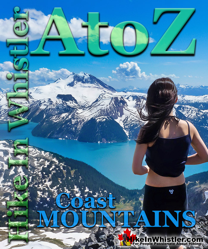
![]() The Coast Mountains run from the Yukon down to Vancouver along the west coast of British Columbia in a band that averages 300 kilometres wide(190 miles). The length of the Coast Mountains is roughly 1600 kilometres(1000 miles). They are often referred to as the BC Coastal Range or the Coast Range. The Coast Mountains are comprised of three mountain ranges, the Pacific Ranges, the Kitimat Ranges, and the Boundary Ranges.
The Coast Mountains run from the Yukon down to Vancouver along the west coast of British Columbia in a band that averages 300 kilometres wide(190 miles). The length of the Coast Mountains is roughly 1600 kilometres(1000 miles). They are often referred to as the BC Coastal Range or the Coast Range. The Coast Mountains are comprised of three mountain ranges, the Pacific Ranges, the Kitimat Ranges, and the Boundary Ranges.
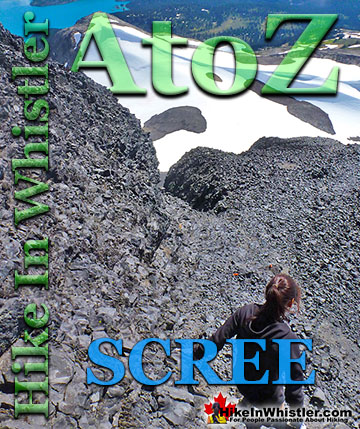
Whistler & Garibaldi Hiking
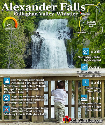
![]() Alexander Falls
Alexander Falls ![]() Ancient Cedars
Ancient Cedars ![]() Black Tusk
Black Tusk ![]() Blackcomb Mountain
Blackcomb Mountain ![]() Brandywine Falls
Brandywine Falls ![]() Brandywine Meadows
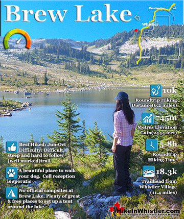
Brandywine Meadows ![]() Brew Lake
Brew Lake ![]() Callaghan Lake
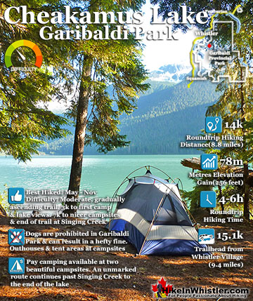
Callaghan Lake ![]() Cheakamus Lake
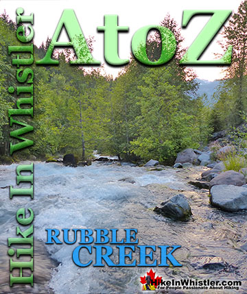
Cheakamus Lake ![]() Cheakamus River
Cheakamus River ![]() Cirque Lake
Cirque Lake ![]() Flank Trail
Flank Trail ![]() Garibaldi Lake
Garibaldi Lake ![]() Garibaldi Park
Garibaldi Park ![]() Helm Creek
Helm Creek ![]() Jane Lakes
Jane Lakes ![]() Joffre Lakes
Joffre Lakes ![]() Keyhole Hot Springs
Keyhole Hot Springs ![]() Logger’s Lake
Logger’s Lake ![]() Madeley Lake
Madeley Lake ![]() Meager Hot Springs
Meager Hot Springs ![]() Nairn Falls
Nairn Falls ![]() Newt Lake
Newt Lake ![]() Panorama Ridge
Panorama Ridge ![]() Parkhurst Ghost Town
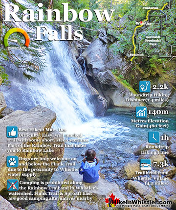
Parkhurst Ghost Town ![]() Rainbow Falls
Rainbow Falls ![]() Rainbow Lake
Rainbow Lake ![]() Ring Lake
Ring Lake ![]() Russet Lake
Russet Lake ![]() Sea to Sky Trail
Sea to Sky Trail ![]() Skookumchuck Hot Springs
Skookumchuck Hot Springs ![]() Sloquet Hot Springs
Sloquet Hot Springs ![]() Sproatt East
Sproatt East ![]() Sproatt West
Sproatt West ![]() Taylor Meadows
Taylor Meadows ![]() Train Wreck
Train Wreck ![]() Wedgemount Lake
Wedgemount Lake ![]() Whistler Mountain
Whistler Mountain
![]() January
January ![]() February
February ![]() March
March ![]() April
April ![]() May
May ![]() June
June ![]() July
July ![]() August
August ![]() September
September ![]() October
October ![]() November
November ![]() December
December
The Pacific Ranges, subsection of the Coast Mountains is the mountainous area along the west coast of BC roughly parallel to Vancouver Island. The Pacific Ranges are divided further into several smaller, easily defined groups of mountain ranges. One of those mountain range groups engulfs Whistler and much of Garibaldi Provincial Park, the Garibaldi Ranges. The Garibaldi Ranges cover an enormous stretch of mountainous terrain between two large river valleys. The Lillooet River valley on the east side and the Cheakamus River/Green Lake valley on the west. Whistler is located on the west edge of the Garibaldi Ranges, while Pemberton near the north end and Vancouver at the south end. The subdivisions of the Garibaldi Ranges include Garibaldi Névé, Fitzsimmons Range, McBride Range, Spearhead Range, Golden Ears, Misty Icefield and the Bastion Range. Of these subsections, four are well known and loved by hard-core Whistler mountaineers and skiers/snowboarders. They are the Fitzsimmons Range, the Spearhead Range, the McBride Range and the Garibaldi Névé.
The Fitzsimmons Range
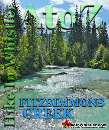
![]() The Fitzsimmons Range is a subsection of the Garibaldi Ranges that covers the area between the valleys of Cheakamus Lake and Fitzsimmons Creek. Fitzsimmons Creek cuts between Whistler Mountain and Blackcomb Mountain and largely originates from the Fitzsimmons Glacier. The Fitzsimmons Glacier and Mount Fitzsimmons are part of the Overlord Massif, which gets its name from the highest peak in the area, Overlord Mountain. Massif is a term used in geology to refer to a compact group of connected mountains that easily identify into one large mountain mass. Massif is a French word that means “massive”. The Fitzsimmons Range includes several locally famous summits, including the summit of Whistler, Oboe Summit, Piccolo Summit and Flute Summit. These form the Musical Bumps trail which is a gorgeous route to the Russet Lake campground in Garibaldi Provincial Park. Next to Russet Lake is The Fissile and next to The Fissile is Overlord Mountain. Near Russet Lake and connecting to the Musical Bumps trail is the Singing Pass trail that ascends along Fitzsimmons Creek to Whistler Village at the base of Whistler Mountain.
The Fitzsimmons Range is a subsection of the Garibaldi Ranges that covers the area between the valleys of Cheakamus Lake and Fitzsimmons Creek. Fitzsimmons Creek cuts between Whistler Mountain and Blackcomb Mountain and largely originates from the Fitzsimmons Glacier. The Fitzsimmons Glacier and Mount Fitzsimmons are part of the Overlord Massif, which gets its name from the highest peak in the area, Overlord Mountain. Massif is a term used in geology to refer to a compact group of connected mountains that easily identify into one large mountain mass. Massif is a French word that means “massive”. The Fitzsimmons Range includes several locally famous summits, including the summit of Whistler, Oboe Summit, Piccolo Summit and Flute Summit. These form the Musical Bumps trail which is a gorgeous route to the Russet Lake campground in Garibaldi Provincial Park. Next to Russet Lake is The Fissile and next to The Fissile is Overlord Mountain. Near Russet Lake and connecting to the Musical Bumps trail is the Singing Pass trail that ascends along Fitzsimmons Creek to Whistler Village at the base of Whistler Mountain.


The Spearhead Range
![]() The Spearhead Range is a subsection of the Garibaldi Ranges that runs in an arc that connects Whistler Mountain and Blackcomb Mountain. The Spearhead Range is effectively the brother of the Fitzsimmons Range which runs east from the summit of Whistler Mountain to Russett Lake. The Spearhead Range covers the area on the north side or Blackcomb Mountain side of Fitzsimmons Creek. Fitzsimmons Creek cuts between Whistler Mountain and Blackcomb Mountain. Where the Fitzsimmons Range ends at Fitzsimmons Creek, the Spearhead Range begins and continues along a set of peaks resembling spearheads to Blackcomb Mountain. These peaks include The Spearhead, Mount Trorey, Tremor, Shatter, Shudder, Quiver, and more. The Spearhead Range is home to the increasingly popular and extraordinarily beautiful Spearhead Traverse. This amazing ski traverse traces a very challenging route from Blackcomb Mountain to Whistler Mountain via the Spearhead Range. It has, in recent years, spawned the Spearhead Huts Project. An ambitious plan to install mountain huts along the Spearhead Traverse. It has considerable public support and funding via donations. The first hut is already well underway and is scheduled for completion in January 2019.
The Spearhead Range is a subsection of the Garibaldi Ranges that runs in an arc that connects Whistler Mountain and Blackcomb Mountain. The Spearhead Range is effectively the brother of the Fitzsimmons Range which runs east from the summit of Whistler Mountain to Russett Lake. The Spearhead Range covers the area on the north side or Blackcomb Mountain side of Fitzsimmons Creek. Fitzsimmons Creek cuts between Whistler Mountain and Blackcomb Mountain. Where the Fitzsimmons Range ends at Fitzsimmons Creek, the Spearhead Range begins and continues along a set of peaks resembling spearheads to Blackcomb Mountain. These peaks include The Spearhead, Mount Trorey, Tremor, Shatter, Shudder, Quiver, and more. The Spearhead Range is home to the increasingly popular and extraordinarily beautiful Spearhead Traverse. This amazing ski traverse traces a very challenging route from Blackcomb Mountain to Whistler Mountain via the Spearhead Range. It has, in recent years, spawned the Spearhead Huts Project. An ambitious plan to install mountain huts along the Spearhead Traverse. It has considerable public support and funding via donations. The first hut is already well underway and is scheduled for completion in January 2019.


McBride Range
![]() The McBride Range is a subsection of the Garibaldi Ranges and covers a 357 square kilometre area east of Cheakamus Lake and Garibaldi Lake. Where the Spearhead Range ends, the McBride Range begins. Owing to its central location in the middle of Garibaldi Provincial Park, the McBride Range is often referred to as the backbone of Garibaldi Park. The McBride Range is a morass of brutally steep mountains and glacier valleys that expert skiers have plotted a route through. The McBride Traverse is an astoundingly difficult and beautiful, week long route through the McBride Range. Along the route you encounter several monster mountains with wonderful names, including Decker Mountain, Mount Patterson, Tremor Mountain, Sir Richard Mountain, The Gatekeeper, Forger Peaks, Isosceles Peak, Mount Carr, The Bookworms and The Sphinx.
The McBride Range is a subsection of the Garibaldi Ranges and covers a 357 square kilometre area east of Cheakamus Lake and Garibaldi Lake. Where the Spearhead Range ends, the McBride Range begins. Owing to its central location in the middle of Garibaldi Provincial Park, the McBride Range is often referred to as the backbone of Garibaldi Park. The McBride Range is a morass of brutally steep mountains and glacier valleys that expert skiers have plotted a route through. The McBride Traverse is an astoundingly difficult and beautiful, week long route through the McBride Range. Along the route you encounter several monster mountains with wonderful names, including Decker Mountain, Mount Patterson, Tremor Mountain, Sir Richard Mountain, The Gatekeeper, Forger Peaks, Isosceles Peak, Mount Carr, The Bookworms and The Sphinx.
Garibaldi Névé
![]() The Garibaldi Névé is the large icefield that stretches out along the east side of Mount Garibaldi. With a size of 35 square kilometers(14 square miles), the Garibaldi Névé is a subdivision of the Garibaldi Ranges, which in turn is a subdivision of the Pacific Ranges of the Coast Mountains. The Garibaldi Névé Traverse is a tremendously beautiful and very treacherous winter skiing route that runs between Elfin Lakes and Garibaldi Lake. It is generally done as a three day expedition beginning and ending at two BC Parks Garibaldi Provincial Park trailheads. The Diamond Head(Garibaldi) trailhead in Squamish and the Rubble Creek, Black Tusk(Garibaldi) trailhead halfway between Squamish and Whistler. A common itinerary is the Diamond Head(Garibaldi) trailhead to Elfin Lakes on the first day. Sleeping in the very nice and well equipped Elfin Lakes hut. The second day covers the difficult Garibaldi Névé which runs from the Opal Cone north of Elfin Lakes to the foot of Sentinel Glacier northeast of The Table. The second night is usually spent at the Burton Hut at the east end of Garibaldi Lake. The third day involves crossing the length of Garibaldi Lake to the Garibaldi Lake campground and then the comparatively easy descent to Rubble Creek. The south to north route is favoured over the north south route because of the net elevation loss and much prized north facing ski descents.
The Garibaldi Névé is the large icefield that stretches out along the east side of Mount Garibaldi. With a size of 35 square kilometers(14 square miles), the Garibaldi Névé is a subdivision of the Garibaldi Ranges, which in turn is a subdivision of the Pacific Ranges of the Coast Mountains. The Garibaldi Névé Traverse is a tremendously beautiful and very treacherous winter skiing route that runs between Elfin Lakes and Garibaldi Lake. It is generally done as a three day expedition beginning and ending at two BC Parks Garibaldi Provincial Park trailheads. The Diamond Head(Garibaldi) trailhead in Squamish and the Rubble Creek, Black Tusk(Garibaldi) trailhead halfway between Squamish and Whistler. A common itinerary is the Diamond Head(Garibaldi) trailhead to Elfin Lakes on the first day. Sleeping in the very nice and well equipped Elfin Lakes hut. The second day covers the difficult Garibaldi Névé which runs from the Opal Cone north of Elfin Lakes to the foot of Sentinel Glacier northeast of The Table. The second night is usually spent at the Burton Hut at the east end of Garibaldi Lake. The third day involves crossing the length of Garibaldi Lake to the Garibaldi Lake campground and then the comparatively easy descent to Rubble Creek. The south to north route is favoured over the north south route because of the net elevation loss and much prized north facing ski descents.
More Whistler & Garibaldi Park Hiking A to Z!

The Best Whistler & Garibaldi Park Hiking Trails!
Whistler & Garibaldi Park Best Hiking by Month!


Explore BC Hiking Destinations!

Whistler Hiking Trails

Squamish Hiking Trails

Vancouver Hiking Trails

Clayoquot Hiking Trails
Victoria Hiking Trails

