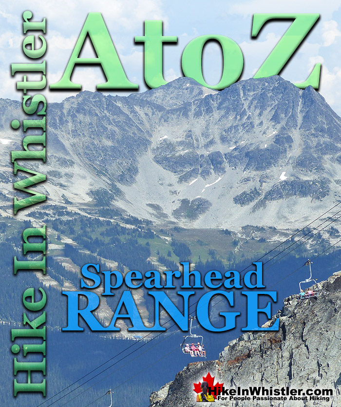
![]() The Spearhead Range is a subsection of the Garibaldi Ranges that runs in an arc that connects Whistler Mountain and Blackcomb Mountain. The Spearhead Range is effectively the brother of the Fitzsimmons Range which runs east from the summit of Whistler Mountain to Russet Lake. The Spearhead Range covers the area on the north side or Blackcomb Mountain side of Fitzsimmons Creek.
The Spearhead Range is a subsection of the Garibaldi Ranges that runs in an arc that connects Whistler Mountain and Blackcomb Mountain. The Spearhead Range is effectively the brother of the Fitzsimmons Range which runs east from the summit of Whistler Mountain to Russet Lake. The Spearhead Range covers the area on the north side or Blackcomb Mountain side of Fitzsimmons Creek.
Whistler & Garibaldi Hiking
![]() Alexander Falls
Alexander Falls ![]() Ancient Cedars
Ancient Cedars ![]() Black Tusk
Black Tusk ![]() Blackcomb Mountain
Blackcomb Mountain ![]() Brandywine Falls
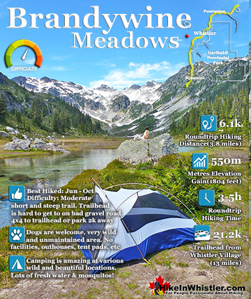
Brandywine Falls ![]() Brandywine Meadows
Brandywine Meadows ![]() Brew Lake
Brew Lake ![]() Callaghan Lake
Callaghan Lake ![]() Cheakamus Lake
Cheakamus Lake ![]() Cheakamus River
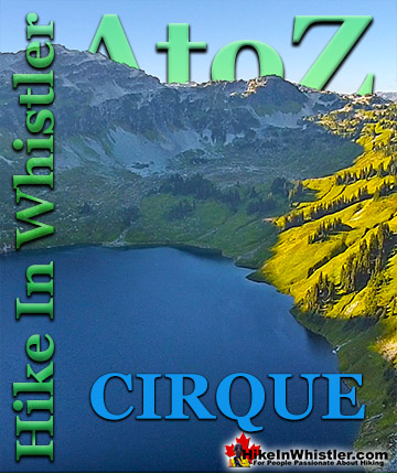
Cheakamus River ![]() Cirque Lake
Cirque Lake ![]() Flank Trail
Flank Trail ![]() Garibaldi Lake
Garibaldi Lake ![]() Garibaldi Park
Garibaldi Park ![]() Helm Creek
Helm Creek ![]() Jane Lakes
Jane Lakes ![]() Joffre Lakes
Joffre Lakes ![]() Keyhole Hot Springs
Keyhole Hot Springs ![]() Logger’s Lake
Logger’s Lake ![]() Madeley Lake
Madeley Lake ![]() Meager Hot Springs
Meager Hot Springs ![]() Nairn Falls
Nairn Falls ![]() Newt Lake
Newt Lake ![]() Panorama Ridge
Panorama Ridge ![]() Parkhurst Ghost Town
Parkhurst Ghost Town ![]() Rainbow Falls
Rainbow Falls ![]() Rainbow Lake
Rainbow Lake ![]() Ring Lake
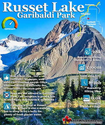
Ring Lake ![]() Russet Lake
Russet Lake ![]() Sea to Sky Trail
Sea to Sky Trail ![]() Skookumchuck Hot Springs
Skookumchuck Hot Springs ![]() Sloquet Hot Springs
Sloquet Hot Springs ![]() Sproatt East
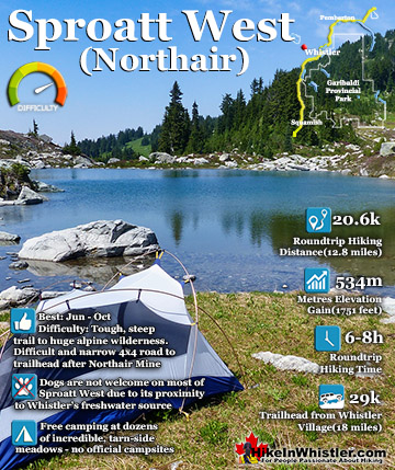
Sproatt East ![]() Sproatt West
Sproatt West ![]() Taylor Meadows
Taylor Meadows ![]() Train Wreck
Train Wreck ![]() Wedgemount Lake
Wedgemount Lake ![]() Whistler Mountain
Whistler Mountain
![]() January
January ![]() February
February ![]() March
March ![]() April
April ![]() May
May ![]() June
June ![]() July
July ![]() August
August ![]() September
September ![]() October
October ![]() November
November ![]() December
December
Fitzsimmons Creek cuts between Whistler Mountain and Blackcomb Mountain. Where the Fitzsimmons Range ends at Fitzsimmons Creek, the Spearhead Range begins and continues along a set of peaks resembling spearheads to Blackcomb Mountain. These peaks include The Spearhead, Mount Trorey, Tremor, Shatter, Shudder, Quiver, and more. The Spearhead Range is home to the increasingly popular and extraordinarily beautiful Spearhead Traverse. This amazing ski traverse traces a very challenging route from Blackcomb Mountain to Whistler Mountain via the Spearhead Range. It has, in recent years, spawned the Spearhead Huts Project. An ambitious plan to install mountain huts along the Spearhead Traverse. It has considerable public support and funding via donations. The first hut, the Kees and Claire Hut was completed in September of 2019. Located at Russet Lake with a gorgeous view over Russet Lake and The Fissile.
The Spearhead Range is a subsection of the Garibaldi Ranges, which in turn is a subsection of the Pacific Ranges of the Coast Mountains. Deriving its name from Mount Garibaldi, the Garibaldi Ranges cover the huge stretch of mountains between two enormous river valleys. The Lillooet River valley on the east side and the Cheakamus River/Green River valley on the west. Whistler is located on the west edge of the Garibaldi Ranges, while Pemberton near the north end and Vancouver at the south end. Other subdivisions of the Garibaldi Ranges include Garibaldi Névé, McBride Range, Fitzsimmons Range, Golden Ears, Misty Icefield and the Bastion Range.


The Spearhead Range is fairly accessible to hike in the summer. The Rendezvous Lodge on Blackcomb Mountain is the starting point to a whole network of beautiful hiking trails that extend along the Spearhead Range. A summer sightseeing lift pass gives you access to all the available lifts and gondolas on Whistler Mountain and Blackcomb Mountain. A new gondola is being built in the summer of 2018, so you have to ride the gondola up from Whistler Village or take the Creekside Gondola up to the Roundhouse Lodge on Whistler Mountain. From the Peak 2 Peak Gondola building next to the Roundhouse Lodge you can ride the spectacular Peak 2 Peak Gondola over to Blackcomb Mountain. The Peak 2 Peak Gondola drops you next to the Rendezvous Lodge and the start of the wonderful Blackcomb Mountain hiking trail network. The Blackcomb Mountain trails almost always have amazing views across the valley to the Fitzsimmons Range that stretches from Whistler Mountain on the far right to Overlord Mountain on the far left. You even catch incredible views of the massive Overlord Glacier from the end of the Overlord Trail.


Blackcomb Mountain in the Spearhead Range
![]() Blackcomb Mountain in July is a stunning place to hike. The Blackcomb Gondola, completed in 2018, takes you all the way to Rendezvous Lodge and Peak2Peak Gondola. The Blackcomb Mountain trails start the moment you exit either the Blackcomb Gondoal or the Peak2Peak Gondola, and immediately give you stunning views of Whistler valley. The trail then ascends up and along a winding route that opens up to great views across to Whistler Mountain. At every trail junction you can circle back to where you started or continue another leg. At each turn you have very nice mapboards and signs indicating where to go and how long you likely will take to hike it and return in time for the Peak2Peak which stops around 4pm.
Blackcomb Mountain in July is a stunning place to hike. The Blackcomb Gondola, completed in 2018, takes you all the way to Rendezvous Lodge and Peak2Peak Gondola. The Blackcomb Mountain trails start the moment you exit either the Blackcomb Gondoal or the Peak2Peak Gondola, and immediately give you stunning views of Whistler valley. The trail then ascends up and along a winding route that opens up to great views across to Whistler Mountain. At every trail junction you can circle back to where you started or continue another leg. At each turn you have very nice mapboards and signs indicating where to go and how long you likely will take to hike it and return in time for the Peak2Peak which stops around 4pm.

Whistler Mountain, Musical Bumps and Russet Lake
![]() Whistler Mountain's huge winter snowfalls mean that alpine hiking usually takes until late June to open up. So July and August are the months where the Whistler Mountain hiking trails are clear of snow and beautiful. Valleys of flowers, distant glaciers, alpine lakes, and plenty of hiking trails to choose from. From the Roundhouse you can start hiking the Musical Bumps trail towards Russet Lake or hike down to the Peak Express Chair and ride up to the summit of Whistler Mountain. An easy interpretive hiking trail loops around the summit and the more challenging Half Note and High Note trails run out along the ridge that overlooks the Whistler valley and Cheakamus Lake. The High Note trail eventually links to the Musical Bumps trail which takes you to Russet Lake in Garibaldi Provincial Park.
Whistler Mountain's huge winter snowfalls mean that alpine hiking usually takes until late June to open up. So July and August are the months where the Whistler Mountain hiking trails are clear of snow and beautiful. Valleys of flowers, distant glaciers, alpine lakes, and plenty of hiking trails to choose from. From the Roundhouse you can start hiking the Musical Bumps trail towards Russet Lake or hike down to the Peak Express Chair and ride up to the summit of Whistler Mountain. An easy interpretive hiking trail loops around the summit and the more challenging Half Note and High Note trails run out along the ridge that overlooks the Whistler valley and Cheakamus Lake. The High Note trail eventually links to the Musical Bumps trail which takes you to Russet Lake in Garibaldi Provincial Park.

Russet Lake in Garibaldi Provincial Park
![]() Russet Lake is a fantastic hiking destination as it is located close to where the Fitzsimmons Range meets the Spearhead Range and at the foot of The Fissile. The Fitzsimmons Range is the range of mountains that includes Whistler Mountain. The Spearhead Range is the mountain range that lays across the valley, cut by Fitzsimmons Creek. If you have ever been on the Peak2Peak Gondola that connects Whistler Mountain and Blackcomb Mountain, you would have noticed at the mid-point a river that runs down the valley. This is Fitzsimmons Creek which is fed by Russet Lake and Overlord Glacier as well as hundreds of small streams. Russet Lake can be hiked to via the free, BC Parks Garibaldi Provincial Park trail that starts a couple hundred metres up from the base of Whistler Mountain. The big bus stop on Blackcomb Way has a trailhead mapboard for the Singing Pass trail to Russet Lake. It is quite a long and boring trail that constantly ascends for about a dozen kilometres through the forest before getting scenic. A nicer alternative is to buy a lift pass and ride the Whistler Gondola up Whistler Mountain, then hike the Musical Bumps trail or the High Note trail to Russet Lake.
Russet Lake is a fantastic hiking destination as it is located close to where the Fitzsimmons Range meets the Spearhead Range and at the foot of The Fissile. The Fitzsimmons Range is the range of mountains that includes Whistler Mountain. The Spearhead Range is the mountain range that lays across the valley, cut by Fitzsimmons Creek. If you have ever been on the Peak2Peak Gondola that connects Whistler Mountain and Blackcomb Mountain, you would have noticed at the mid-point a river that runs down the valley. This is Fitzsimmons Creek which is fed by Russet Lake and Overlord Glacier as well as hundreds of small streams. Russet Lake can be hiked to via the free, BC Parks Garibaldi Provincial Park trail that starts a couple hundred metres up from the base of Whistler Mountain. The big bus stop on Blackcomb Way has a trailhead mapboard for the Singing Pass trail to Russet Lake. It is quite a long and boring trail that constantly ascends for about a dozen kilometres through the forest before getting scenic. A nicer alternative is to buy a lift pass and ride the Whistler Gondola up Whistler Mountain, then hike the Musical Bumps trail or the High Note trail to Russet Lake.

Both are shorter than the Singing Pass trail, and constantly amazing. Also, you ride most of the ascent by gondola. No matter what way you hike to Russet Lake, if you do it in July you will likely have gorgeous weather and a wonderful time at the lake. Russet Lake has a cute old hut that anyone can use(with a campsite park permit) as well as several nice tent clearings. The campsite sits near the base of The Fissile, at the shore of Russet Lake, and overlooking Overlord Glacier. A small stream runs along the campsite that you can drink straight from. From the campsite you can hike in several directions to see some incredible sights. The Fissile is a challenging scramble.

Overlord Glacier is just an easy hike down the valley. The small and comparatively warm, Adit Lakes sit up from Russet Lake on the opposite side of the valley from The Fissile. Russet Lake is paradise in July, but keep in mind that it can get busy, especially on weekends. If you are camping, get your BC Parks camping permit ahead of time. If you are day hiking, you don’t have to pay a think, except the Whistler lift pass if you hike in that way. If you hike up Singing Pass, it is of course free, and you can return via Whistler Mountain on the Peak Express Chair and/or the Whistler Gondola for free.


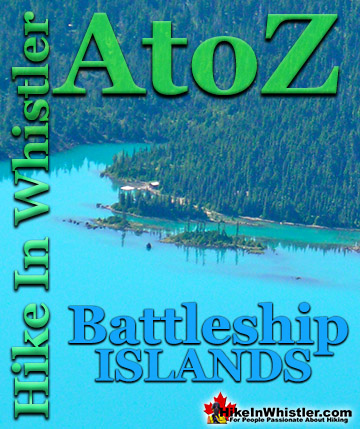
More Whistler & Garibaldi Park Hiking A to Z!

The Best Whistler & Garibaldi Park Hiking Trails!
Whistler & Garibaldi Park Best Hiking by Month!


Explore BC Hiking Destinations!

Whistler Hiking Trails

Squamish Hiking Trails

Vancouver Hiking Trails

Clayoquot Hiking Trails
Victoria Hiking Trails

