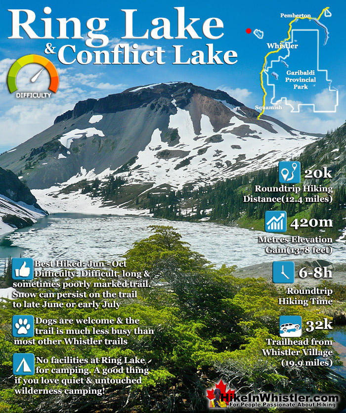
![]() Ring Lake is a fantastically serene and wonderfully remote lake similar to Cirque Lake, but considerably farther to hike to reach it. The 10 kilometre(6.2 mile) hike takes you through a rarely hiked forest, then to an idyllic meadow filled with ponds and ringed with distant, mountains, then finally up an over some steep terrain to reveal this very hidden lake. 5 kilometres(3.1 miles) into the hike you come to Conflict Lake with trails running around it.
Ring Lake is a fantastically serene and wonderfully remote lake similar to Cirque Lake, but considerably farther to hike to reach it. The 10 kilometre(6.2 mile) hike takes you through a rarely hiked forest, then to an idyllic meadow filled with ponds and ringed with distant, mountains, then finally up an over some steep terrain to reveal this very hidden lake. 5 kilometres(3.1 miles) into the hike you come to Conflict Lake with trails running around it.
 Idyllic lake high up in the mountains
- Nice and varied trail infrequently hiked
- Lots of accessible alpine routes beyond the lake
- Black Tusk's little brother sits across the lake
- Ring Lake feels wonderfully far from the world
- Trail starts from beautiful Callaghan Lake
 The trail is longer than other Whistler trails
- No wow factor like Wedgemount or Joffre Lakes
- Easy to lose the trail if you aren't careful
- Local tour company marches groups through
Whistler & Garibaldi Hiking
![]() Alexander Falls
Alexander Falls ![]() Ancient Cedars
Ancient Cedars ![]() Black Tusk
Black Tusk ![]() Blackcomb Mountain
Blackcomb Mountain ![]() Brandywine Falls
Brandywine Falls ![]() Brandywine Meadows
Brandywine Meadows ![]() Brew Lake
Brew Lake ![]() Callaghan Lake
Callaghan Lake ![]() Cheakamus Lake
Cheakamus Lake ![]() Cheakamus River
Cheakamus River ![]() Cirque Lake
Cirque Lake ![]() Flank Trail
Flank Trail ![]() Garibaldi Lake
Garibaldi Lake ![]() Garibaldi Park
Garibaldi Park ![]() Helm Creek
Helm Creek ![]() Jane Lakes
Jane Lakes ![]() Joffre Lakes
Joffre Lakes ![]() Keyhole Hot Springs
Keyhole Hot Springs ![]() Logger’s Lake
Logger’s Lake ![]() Madeley Lake
Madeley Lake ![]() Meager Hot Springs
Meager Hot Springs ![]() Nairn Falls
Nairn Falls ![]() Newt Lake
Newt Lake ![]() Panorama Ridge
Panorama Ridge ![]() Parkhurst Ghost Town
Parkhurst Ghost Town ![]() Rainbow Falls
Rainbow Falls ![]() Rainbow Lake
Rainbow Lake ![]() Ring Lake
Ring Lake ![]() Russet Lake
Russet Lake ![]() Sea to Sky Trail
Sea to Sky Trail ![]() Skookumchuck Hot Springs
Skookumchuck Hot Springs ![]() Sloquet Hot Springs
Sloquet Hot Springs ![]() Sproatt East
Sproatt East ![]() Sproatt West
Sproatt West ![]() Taylor Meadows
Taylor Meadows ![]() Train Wreck
Train Wreck ![]() Wedgemount Lake
Wedgemount Lake ![]() Whistler Mountain
Whistler Mountain
![]() January
January ![]() February
February ![]() March
March ![]() April
April ![]() May
May ![]() June
June ![]() July
July ![]() August
August ![]() September
September ![]() October
October ![]() November
November ![]() December
December
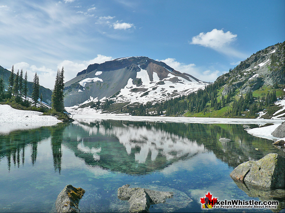
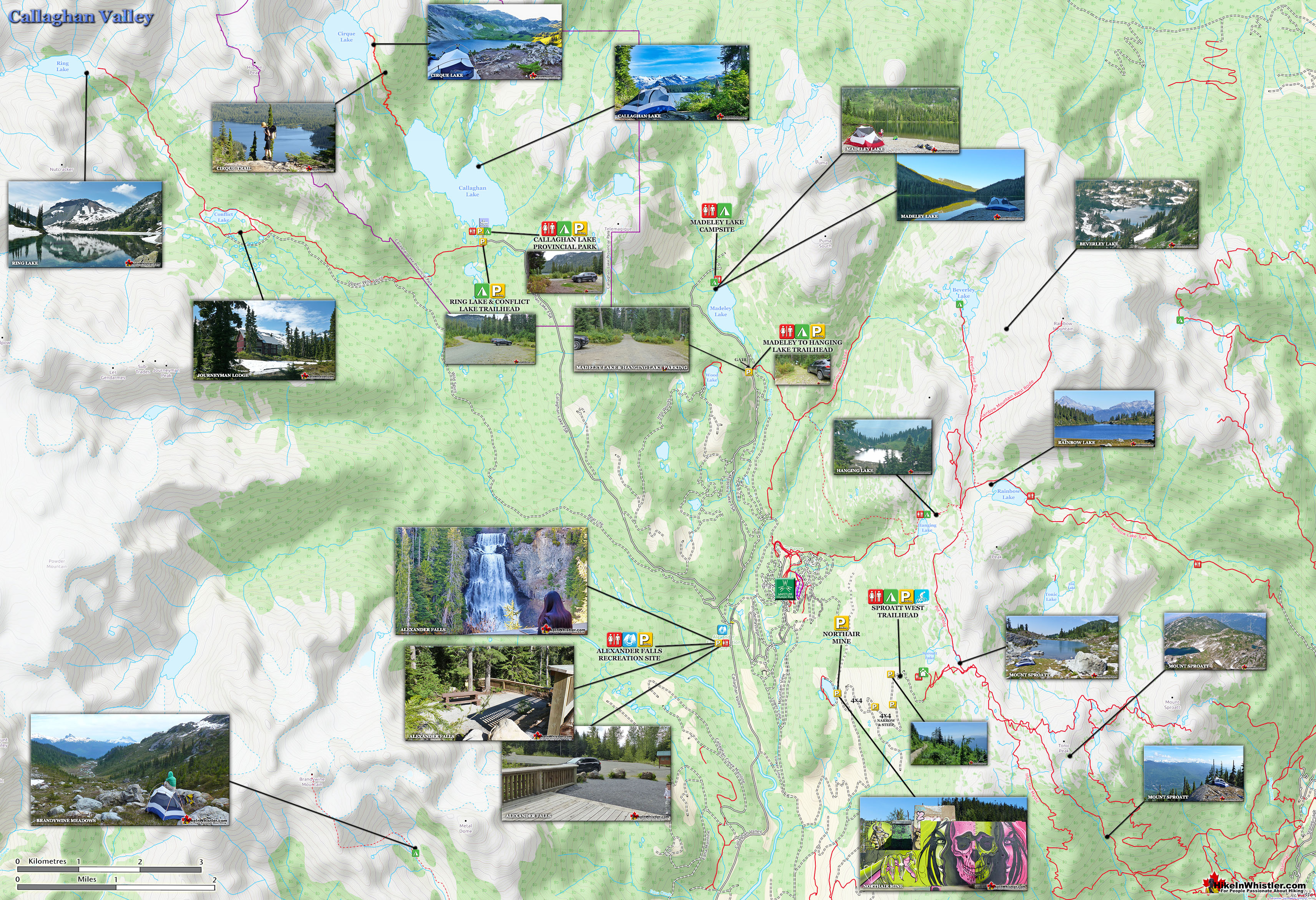
Journeyman Lodge sits near Conflict Lake. A wilderness lodge operated by Callaghan Country, a tour company that operates in the valley. They offer a range of alpine activities, far more serene than across the valley on Whistler Mountain and Blackcomb Mountain. Signs along the trail and at Conflict Lake indicate which trail to take to reach Ring Lake, a further 5 kilometres from Conflict Lake. The trail from Conflict Lake to Ring Lake passes through a huge valley for a couple kilometres, then abruptly ascends on the right side of the valley. The trail is poorly marked in this section and you have to keep bearing right to avoid descending back into the valley. The trail is occasionally maintained, however owing to heavy winter snow, the trail gets pretty brutalized every winter. Because of the winter destruction, the visible trail in some parts disappears and you find yourself wondering if you are still on your way to Ring Lake. The key to staying on the right route, you quickly figure out, is to keep to the right side of the valley. Three kilometres of, at times very steep, but not technical trail gets you to the magnificent Ring Lake and the imposing Ring Mountain across the emerald green water.

Finding the Trailhead to Ring Lake
The trailhead to Ring and Conflict Lakes is very close to the Callaghan Lake Provincial Park campsite. From the campsite, drive a couple hundred metres as if returning to Whistler and you will see a clearing on the right and a very well worn trail. From this trail you will see plenty of signs to guide you first to Conflict Lake in 5 kilometres, then Ring Lake, another 5 kilometres past Conflict. The 5 kilometre hike to Conflict Lake is quite relaxed and easy as you don't gain any significant elevation. The 5 kilometres from Conflict to Ring Lake is very steep, and though marked well with flagging tape and cairns, if often difficult to follow. Though the 10 kilometre trail is comparatively longer than most other Whistler hiking trails, the reward when you reach the end is magnificent. Unspoiled wilderness. Jagged mountain peaks, evidently from geologically recent volcanic activity. Snowy mountains beyond, and the stunningly clear and serene Ring Lake filling the valley. Ring Lake and Conflict Lake have their own, unmarked trailhead, a stones throw from the parking/campsite area for Callaghan Lake Provincial Park. It is very easy to find once you arrive at Callaghan Lake. Just a few metres outside/before the campsite/parking area at Callaghan Lake you will see a large area at the edge of the road with room for about 8 cars. The wide and very visible trail enters the forest and almost immediately crosses a large bridge over Callaghan Creek. Shortly after that you will spot trail signs at various stretches of the trail. Easy to follow and with good distance markers.
The Bridge Over Callaghan Creek


Conflict Lake

Callaghan Country Lodge


Trailhead & Parking Directions to Ring Lake
![]()
![]()
![]() The unmarked Ring & Conflict Lake trailhead and parking is just a couple hundred metres from the Callaghan Lake campsite and parking. Callaghan Lake Provincial Park is 32 kilometres (19.9 miles) from Whistler Village and takes about an hour to drive there. There are currently no public transit options to get there and the long and bumpy logging road to Callaghan Lake would almost certainly rule out taxi companies taking you there. Biking there is also too far and too steep to be realistic for most. Driving directions from Whistler Village are pretty straight forward, and there are good signs all the way there. From Village Gate Blvd in Whistler Village drive 13.8 kilometres towards Vancouver on the Sea to Sky Highway. Turn right at the turnoff for Callaghan Lake Provincial Park. Drive up the scenic and windy Callaghan Valley road for 9.6 kilometres. The sign for Callaghan Lake Provincial Park will be just after Alexander Falls Provincial Park and just before Whistler Olympic Park. You will turn left, cross a bridge and drive up the horrendously potholed Callaghan Lake FSR for 8.5 kilometres. Most vehicles can make it to the lake but with extreme caution and care at several waterbars and the frequent and very deep potholes. The deep waterbars start immediately on the road, so you will know right away if your car will make it. You often see full size motorhomes at the campsite so as long as you drive slow, most vehicles should make it slowly but surely.
The unmarked Ring & Conflict Lake trailhead and parking is just a couple hundred metres from the Callaghan Lake campsite and parking. Callaghan Lake Provincial Park is 32 kilometres (19.9 miles) from Whistler Village and takes about an hour to drive there. There are currently no public transit options to get there and the long and bumpy logging road to Callaghan Lake would almost certainly rule out taxi companies taking you there. Biking there is also too far and too steep to be realistic for most. Driving directions from Whistler Village are pretty straight forward, and there are good signs all the way there. From Village Gate Blvd in Whistler Village drive 13.8 kilometres towards Vancouver on the Sea to Sky Highway. Turn right at the turnoff for Callaghan Lake Provincial Park. Drive up the scenic and windy Callaghan Valley road for 9.6 kilometres. The sign for Callaghan Lake Provincial Park will be just after Alexander Falls Provincial Park and just before Whistler Olympic Park. You will turn left, cross a bridge and drive up the horrendously potholed Callaghan Lake FSR for 8.5 kilometres. Most vehicles can make it to the lake but with extreme caution and care at several waterbars and the frequent and very deep potholes. The deep waterbars start immediately on the road, so you will know right away if your car will make it. You often see full size motorhomes at the campsite so as long as you drive slow, most vehicles should make it slowly but surely.
Waterbar on the Callaghan Lake FSR

Callaghan Lake FSR Gated Until May 15th
This logging road is usually deep with snow until mid June. If you attempt to drive this road in early summer, be sure to bring a shovel and rope in case you find yourself stuck in the snow. You will have spotty cell reception all the way to the Callaghan campsite, however you may have to walk along the road until you catch a usable signal. Access to Callaghan Lake FSR is blocked by a chain at the bridge until May 15th every year.

After May 15th you will often find a huge pile of snow blocking Callaghan Lake FSR just past the bridge. It keeps people from driving up and getting stuck in the snow on the higher elevations. When this snow pile melts, it is a good indication that the road to Callaghan Lake may be clear as well.
Ring & Conflict Lake Unmarked Parking
As you approach the parking and campsite area for Callaghan Lake Provincial Park you will see the unmarked parking area for Ring & Conflict Lake on your left. There is room for about 6 vehicles at this unmarked trailhead. There are plenty more parking spaces at Callaghan Lake, an outhouse, boat launch and several nice drive-to campsites.
The Unmarked Parking and Trailhead for Ring & Conflict Lake


Callaghan Creek Bridge Near the Ring & Conflict Lake Trailhead

Callaghan Creek Near the Trailhead

Callaghan Lake Campsite

More Great Hiking Around Ring Lake
![]() The Callaghan Valley lays quietly across from Whistler despite being home to some incredible hikes. Ring & Conflict Lake and Cirque Lake are two phenomenal hiking destinations in the valley that few people have even heard of. Cirque Lake resides high above Callaghan Lake at the end of a very steep, though very short hike that runs startlingly close to the almost vertical falls that empty Cirque Lake. Ring and Conflict Lakes sit high up in the mountains 10 kilometres west of Callaghan Lake. You will never, or at least comparatively rarely see anyone on the trails to Cirque Lake, Conflict Lake or Ring Lake for several reasons. First is location. Despite the Callaghan Valley being tremendously beautiful geographically. The distant mountains are snow covered, even in September. The lakes are emerald coloured and crystal clear. The forests are an untouched blanket of beautiful green. The creeks, rivers and waterfalls are everywhere in your view or if not in view, heard as distant sounds of running water. Despite this beauty, it seems that the biggest reason for the Callaghan Valley's lack of use as a hiking destination is its location next to Garibaldi Provincial Park.
The Callaghan Valley lays quietly across from Whistler despite being home to some incredible hikes. Ring & Conflict Lake and Cirque Lake are two phenomenal hiking destinations in the valley that few people have even heard of. Cirque Lake resides high above Callaghan Lake at the end of a very steep, though very short hike that runs startlingly close to the almost vertical falls that empty Cirque Lake. Ring and Conflict Lakes sit high up in the mountains 10 kilometres west of Callaghan Lake. You will never, or at least comparatively rarely see anyone on the trails to Cirque Lake, Conflict Lake or Ring Lake for several reasons. First is location. Despite the Callaghan Valley being tremendously beautiful geographically. The distant mountains are snow covered, even in September. The lakes are emerald coloured and crystal clear. The forests are an untouched blanket of beautiful green. The creeks, rivers and waterfalls are everywhere in your view or if not in view, heard as distant sounds of running water. Despite this beauty, it seems that the biggest reason for the Callaghan Valley's lack of use as a hiking destination is its location next to Garibaldi Provincial Park.

The beautiful and well known park focuses all the throngs of hikers in the justifiably popular areas of Garibaldi Lake, Black Tusk, Taylor Meadows, Wedgemount Lake and Elfin Lakes. Laying outside this monstrously famous Provincial Park exists the relatively untouched and unknown Callaghan Valley. The second big reason of course is that the hikes in the Callaghan Valley are unmaintained or at least rarely maintained. The campsite at Callaghan Lake is maintained to a very high standard, however the trail to Cirque Lake is by comparison unmaintained. Just finding the Cirque Lake trailhead is a challenge. There are flagging tapes along the trail after the trailhead. The third reason, at least for Cirque Lake, for being hardly hiked is the fact that the unmarked trailhead starts at the far end of Callaghan Lake.


So you need to canoe or otherwise, boat there. This added impediment surely contributes to this wonderful trail, continuing to be infrequently hiked. The fourth, more practical, yet inexplicable reason is that the road to Callaghan Lake Provincial Park is horribly unmaintained. Obviously grading this poor logging road is expensive, however it is beyond neglected. Boulders, waterbars and potholes exist on this road to such a high degree that the neglect seems malicious. In fact, the moment you leave the deluxe road to the Olympic Nordic Centre the monstrous potholes begin, presumably scaring away any 4x4 lacking tourists Callaghan Lake Provincial Park bound. The Callaghan Valley gets a lot of drive in traffic since the recent paving of the road and installation of the fabulous Whistler Olympic Park for the 2010 Olympics. This road is open year-round and in the summer is frequented by bear watchers. The grass along the road is a favourite for bears and in the summer months consistently ensures at least a couple bears along the route to the Callaghan Valley. Madeley Lake is an amazing place to camp.

If looking for solitude at a paradise, mountain lake, Madeley Lake is hard to beat. Though somewhat popular with fishing, you are still likely to rarely see anyone at the lake in the summer and never in the fall. Once in a while you will see a car or two at the trailhead to Hanging Lake. If you have a canoe, Madeley Lake is a great place to paddle around or just float in the sun. The trail from Madeley Lake to Hanging Lake is nice, however at times muddy. Free of snow, usually from June to November most years(late May in 2015), this trail is a great way to avoid the much busier Rainbow Lake trail that starts from the Whistler side of this area. If you can arrange to have someone drop you off at the trailhead you can hike all the way to Whistler Village via the Rainbow Lake trail and the Valley Trail. The entire distance is about 23 kilometres and should only take about 6 hours, much of it steadily descending the beautiful Rainbow Trail. The route is well marked and there are several map-boards along the route ensuring you find your way safely.
Whistler's Best Hiking Trails!
Whistler & Garibaldi Park Best Hiking by Month!


Explore BC Hiking Destinations!

Whistler Hiking Trails

Squamish Hiking Trails

Vancouver Hiking Trails

Clayoquot Hiking Trails
Victoria Hiking Trails

