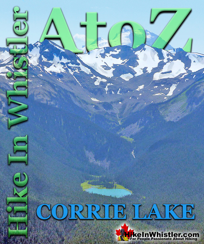
Corrie Lake is the surreal looking lake that can be seen across the valley from Whistler Mountain. While hiking the High Note trail along Whistler Mountain it slowly comes into view, seemingly hanging in the forest on an otherwise steep sided, broad mountain. The broad mountain that Corrie Lake sits within is called Corrie Ridge, which extend from Corrie Peak to Gentian Ridge. The ridge is named Corrie Ridge because Corrie Peak is the highest peak along the ridge.
Corrie Lake, Corrie Peak, Corrie Ridge, Corrie Glacier and Corrie Creek all derive their name from the observation in 1916 by provincial botanist John Davidson who compared the lake to the corries of Lochnagar and Braeriach in the Cairngorms of Scotland. Corries are glacier carved lakes usually found on the north facing slopes of mountains in the northern hemisphere. Corries in the western world are more commonly called cirques, though corrie is generally used in the United Kingdom. A corrie or cirque results from a north-facing glacier repeatedly gouging out a hollow where a lake forms. Every year as more rock is gouged out, the deeper, thicker and heavier the glacier gets and therefore the gouging force progressively increases. Interestingly, this process tends to confine itself to a somewhat standard size. Generally corries/cirques settle into a circumference of just under one kilometre. The back wall of the corrie/cirque gets steeper due to freeze-thaw weathering and plucking and the base becomes deeper due to erosion. The glacier is heavier as it moves downhill causing it to move in a circular motion known as rotational slip as it moves out of the hollow it created. The lake produced by this geologic process is circular in shape. Cirque is derived by the French from the Latin word for circus, which translates to English as circle. Corrie Lake has a somewhat circular shape and Cirque Lake in Callaghan Valley has an even more symmetrical shape to it.
Cirque Lake is a wild and beautiful lake that hides high above and beyond Callaghan Lake in Callaghan Lake Provincial Park. What makes Cirque Lake special among the other sensationally beautiful lakes in the Whistler area is both its location and geologically formed shape. It sits high above Callaghan Lake, which itself is a gorgeous, mountain lake. The remoteness of Callaghan Lake is a bit of a mirage due to the fact that you can drive right to it!
More Whistler & Garibaldi Park Hiking A to Z!
Whistler can be expensive. Everything worth doing seems to cost a lot of money. But if you step back from the noise and crowds you may spot some secret ...
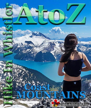
The Coast Mountains run from the Yukon down to Vancouver along the west coast of British Columbia in a band that averages 300 kilometres wide(190 miles). ...
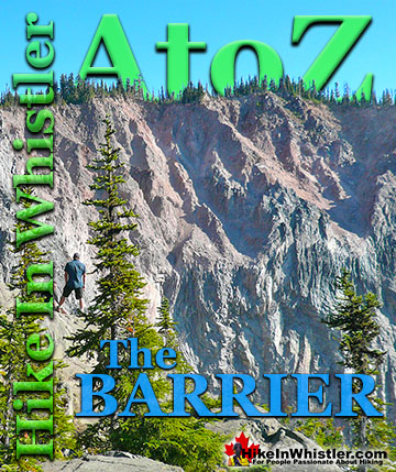
The Barrier formed as a result of huge lava flows from Clinker Peak on the west shoulder of Mount Price during the last ice age. About thirteen thousand ...
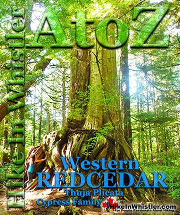
Western redcedar is a very large tree commonly found in the Pacific Northwest. Frequently growing up to 70 metres and with a trunk diameter of 7 metres, ...
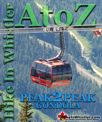
The Peak 2 Peak Gondola connects Whistler Mountain and Blackcomb Mountain at a dizzying height of 436 metres(1427 feet). It runs all winter and in the ...
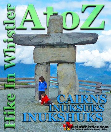
Cairns, inukshuks or inuksuks are a pile or arrangement of rocks used to indicate a route, landmark or a summit. The word cairn originates from the ...
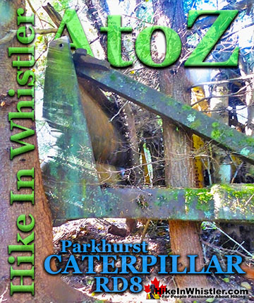
The second Caterpillar tractor in Parkhurst Ghost Town is considerably harder to find despite being just a few metres from the hulking Caterpillar at the shore ...
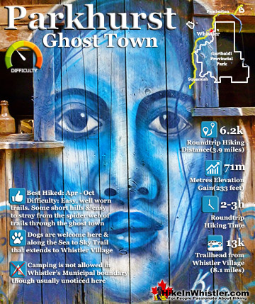
Whistler has an absurd number of wonderful and free hiking trails and Parkhurst Ghost Town certainly ranks as the most unusual and interesting. Parkhurst was a little logging town perched on the edge of Green ...
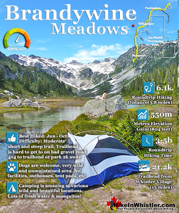
Brandywine Meadows is a nice, relatively short hike to a massive flower filled valley high up in Callaghan Valley. Located 40 minutes south of Whistler, this tough and sometimes muddy trail gains a huge 550 ...
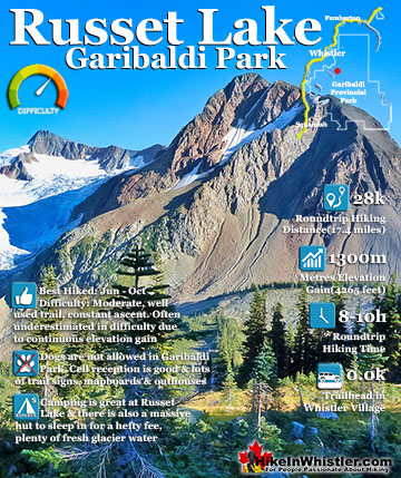
Russet Lake is a surreal little paradise that lays at the base of The Fissile, in Garibaldi Provincial Park. The Fissile is the strikingly bronze mountain visible from Whistler Village. From the Village ...
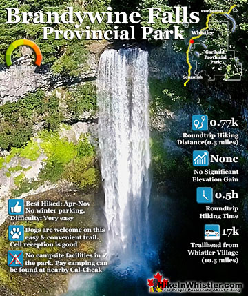
Brandywine Falls is one of the must see sights on the drive to or from Whistler, and arguably the nicest of Whistler’s numerous beautiful waterfalls. Located about halfway between Squamish and Whistler, the ...
July is a wonderful time to hike in Whistler and Garibaldi Provincial Park. The weather is beautiful and the snow on high elevation hiking trails is long ...
August hiking in Whistler definitely has the most consistently great, hot weather. You can feel the rare pleasure of walking across a glacier shirtless and ...
September hiking in Whistler is possibly the best month of all. The snow has melted far up to the mountain tops, yet the temperatures are still quite ...
Hiking in Whistler in October is often unexpectedly stunning. The days are much shorter and colder but the mountains are alive with colour from the fall ...
Hiking in Whistler is spectacular and wonderfully varied. Looking at a map of Whistler you see an extraordinary spider web of hiking trails that are unbelievably numerous. Easy trails, moderate trails and challenging hiking trails are all available. Another marvellous ...
Squamish is located in the midst of a staggering array of amazing hiking trails. Garibaldi Provincial Park sprawls alongside Squamish and up and beyond Whistler. Tantalus Provincial Park lays across the valley to the west and the wonderfully remote Callaghan Valley ...
Vancouver is surrounded by seemingly endless hiking trails and mountains to explore. Massive parks line up one after another. Mount Seymour Provincial Park, Lynn Canyon Park, Grouse Mountain, Cypress Park and the enormous Garibaldi Park all contribute to Vancouver ...
Clayoquot Sound has a staggering array of hiking trails within it. Between Tofino and Ucluelet, Pacific Rim Park has several wilderness and beach trails, each one radically different from the last. The islands in the area are often Provincial parks on their own with ...
Victoria has a seemingly endless number of amazing hiking trails. Most take you to wild and beautiful Pacific Ocean views and others take you to tranquil lakes in beautiful BC Coastal Rainforest wilderness. Regional Parks and Provincial Parks are everywhere you turn ...
The West Coast Trail was created after decades of brutal and costly shipwrecks occurred along the West Coast of Vancouver Island. One shipwreck in particular was so horrific, tragic and unbelievable that it forced the creation of a trail along the coast, which ...