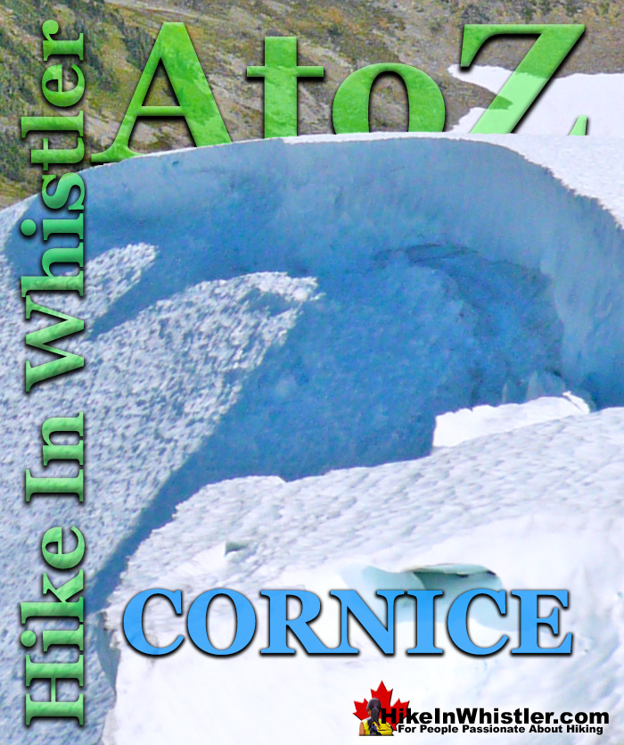
Cornice: a wind deposited wave of snow on a ridge, often overhanging a steep slope or cliff. They are the result of snow building up on the crest of a mountain. Cornices are extremely dangerous to travel on or below. A common refrain of climbers is that if you can see the drop-off of a cornice, you are too close to the edge. Cornices are dangerous for several reasons. They can collapse from hiking across or they can collapse from above.
A third danger to consider is the fact that they can often trigger a massive avalanche that extends a considerable distance from its starting point. The cornice shown in the above and below images are of Panorama Ridge in Garibaldi Provincial Park, Whistler. Panorama Ridge is easily one of the most amazing hikes in Garibaldi Provincial Park. The 15 kilometre hike from the trailhead at Rubble Creek to Panorama Ridge takes you through beautiful and deep forests, across countless idyllic streams, through meadows filled with flowers, and past dozens of jaw dropping viewpoints. The amazing views start once you reach Taylor Meadows and get even more spectacular as the trail progresses. Once you arrive at Panorama Ridge and its phenomenal vantage point, high above Garibaldi Park, you will stare in wonder. Mesmerized first by Garibaldi Lake, far below you and looking unnaturally blue, the lake looks amazing surrounded by green, untouched wilderness and snow capped mountains. The main trailhead for Panorama Ridge is at Rubble Creek, 25 kilometres south of Whistler Village on the Sea to Sky Highway you will see a Garibaldi Park sign indicating the turnoff. From the highway a paved road runs for 2 kilometres to the Rubble Creek trailhead and parking area. This is the most popular and close trailhead for Garibaldi Lake, Taylor Meadows and Black Tusk as well as Panorama Ridge.
More Whistler & Garibaldi Park Hiking A to Z!
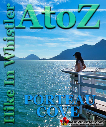
Porteau Cove is a beautiful little stop on the drive to or from Whistler. You will notice the lack of convenient washroom stops on the way to or from ...
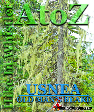
The pale green shub-like growths hanging from trees in the forests around Whistler is called usnea. These bushy, coral-like fruticose lichens anchor to bark ...
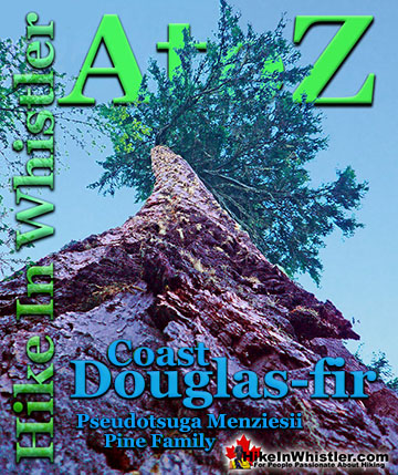
Coast Douglas-fir trees are medium to extremely large trees that you will encounter in Whistler and Garibaldi Park. They are the second tallest conifer ...
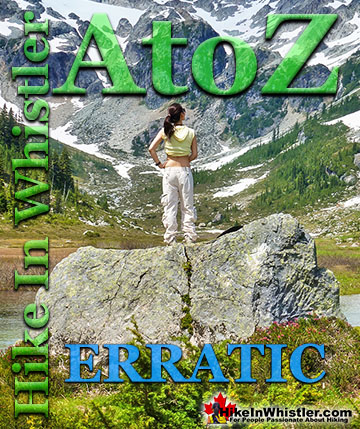
Erratic or glacier erratic is a piece of rock that has been carried by glacial ice, often hundreds of kilometres. Characteristic of their massive size and ...
Alec Dalgleish (1 August 1907 - 26 June 1934) was a highly respected mountaineer and climber out of Vancouver in the 1920's and 1930's. His enthusiasm and ...
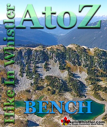
Bench: a flat section in steep terrain. Characteristically narrow, flat or gently sloping with steep or vertical slopes on either side. A bench can be ...
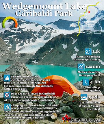
Wedgemount Lake itself is a magnificent destination for a day hike or spectacular overnight beneath the dazzling mountain peaks and stars above Garibaldi Provincial Park. Many sleep under the stars on one of ...
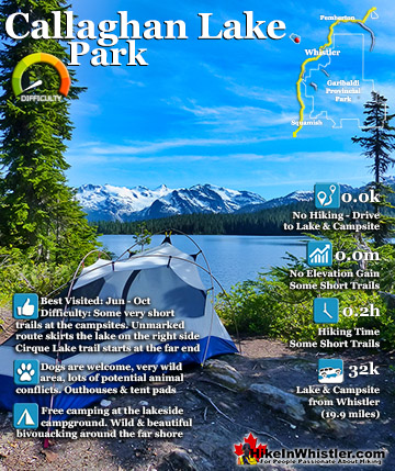
Callaghan Lake Park is a relatively untouched wilderness of rugged mountainous terrain. The valley walls were formed by relatively recent glaciation. Evidence of this can be seen in the considerable glacial ...
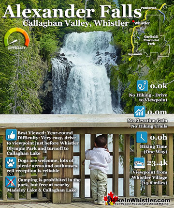
Alexander Falls is a very impressive 43 metre/141 foot waterfall just 30 to 40 minutes south of Whistler in the Callaghan Valley. Open year-round and located just before Whistler Olympic Park where several ...
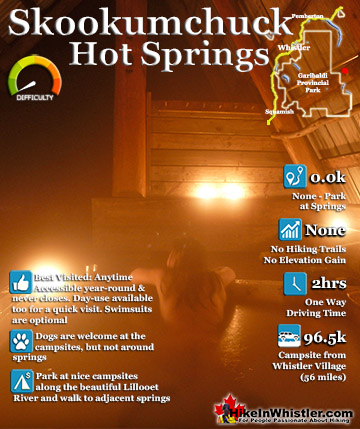
Skookumchuck Hot Springs(aka T'sek Hot Springs and St. Agnes Well), located two hours north of Whistler along the edge of the huge Lillooet River. The name Skookumchuck means "strong water" in the language ...
July is a wonderful time to hike in Whistler and Garibaldi Provincial Park. The weather is beautiful and the snow on high elevation hiking trails is long ...
August hiking in Whistler definitely has the most consistently great, hot weather. You can feel the rare pleasure of walking across a glacier shirtless and ...
September hiking in Whistler is possibly the best month of all. The snow has melted far up to the mountain tops, yet the temperatures are still quite ...
Hiking in Whistler in October is often unexpectedly stunning. The days are much shorter and colder but the mountains are alive with colour from the fall ...
Hiking in Whistler is spectacular and wonderfully varied. Looking at a map of Whistler you see an extraordinary spider web of hiking trails that are unbelievably numerous. Easy trails, moderate trails and challenging hiking trails are all available. Another marvellous ...
Squamish is located in the midst of a staggering array of amazing hiking trails. Garibaldi Provincial Park sprawls alongside Squamish and up and beyond Whistler. Tantalus Provincial Park lays across the valley to the west and the wonderfully remote Callaghan Valley ...
Vancouver is surrounded by seemingly endless hiking trails and mountains to explore. Massive parks line up one after another. Mount Seymour Provincial Park, Lynn Canyon Park, Grouse Mountain, Cypress Park and the enormous Garibaldi Park all contribute to Vancouver ...
Clayoquot Sound has a staggering array of hiking trails within it. Between Tofino and Ucluelet, Pacific Rim Park has several wilderness and beach trails, each one radically different from the last. The islands in the area are often Provincial parks on their own with ...
Victoria has a seemingly endless number of amazing hiking trails. Most take you to wild and beautiful Pacific Ocean views and others take you to tranquil lakes in beautiful BC Coastal Rainforest wilderness. Regional Parks and Provincial Parks are everywhere you turn ...
The West Coast Trail was created after decades of brutal and costly shipwrecks occurred along the West Coast of Vancouver Island. One shipwreck in particular was so horrific, tragic and unbelievable that it forced the creation of a trail along the coast, which ...