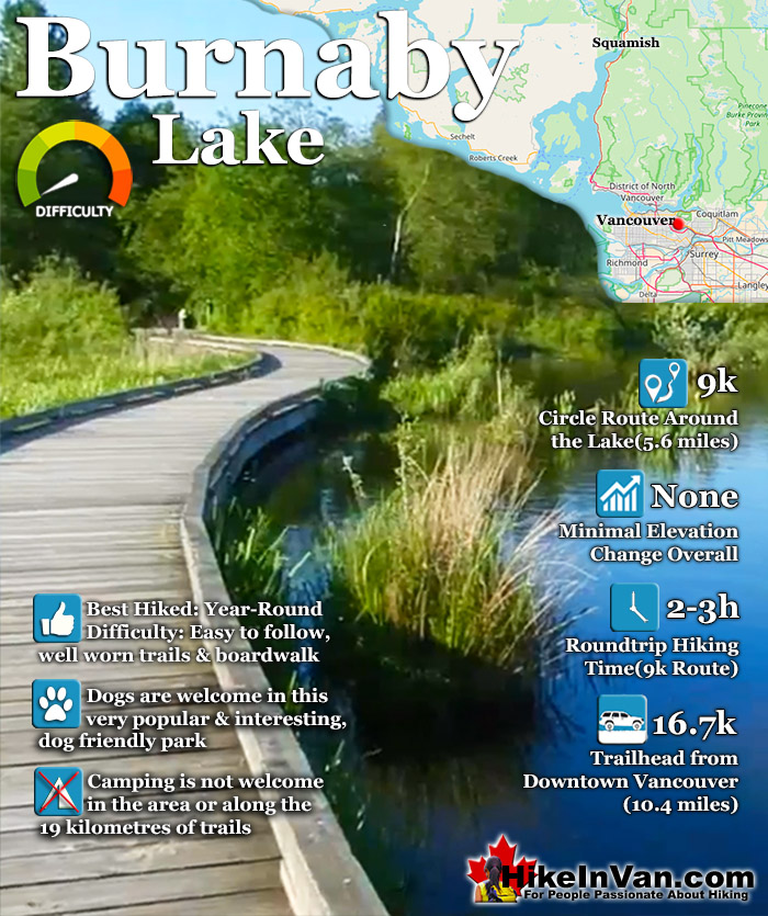
Burnaby Lake Regional Park has a series of trails that add up to 9 kilometres if done in a circular route around the lake. There are in fact 19 kilometres of trails in the park. The various trails include the 2.6 kilometres Cottonwood Trail, the 1.8 kilometres. Brunette Headwaters Trail, the 0.8 kilometres Avalon Trail which connects the Burnaby Equestrian Centre with the Southshore Trail.
The 3.4 kilometres Southshore Trail, and the smaller trails, Conifer Loop, Spruce Trail Loop and the Pavillion Trail. Burnaby Lake is often alive with activity. Whether on the water or around it. Over 400 types of creatures live in the area. Bald eagles, ospreys, herons, beavers and ducks are all frequently seen. Hiking and birdwatching are the main draws to the park, however, canoeing, rowing and kayaking are also done here. The Burnaby Canoe and Kayak Club and the Burnaby Lake Rowing Club practice here quite often. There are several access points to Burnaby Lake Regional Park. The four main access points are the Burnaby Sports Complex entrance, the Glencarin Traiilhead entrance, the Avalon Avenue entrance and the Piper Avenue Entrance.
Directions to Burnaby Lake
The easiest place to start hiking in Burnaby Lake Park is to start at the Nature House on Piper Avenue. From the Lougheed Highway in Burnaby, turn south on Brighton Ave, then right on Winston Ave, then left on Piper Ave.
Best Whistler & Garibaldi Park Hiking Trails!
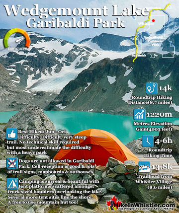
Wedgemount Lake itself is a magnificent destination for a day hike or spectacular overnight beneath the dazzling mountain peaks and stars above Garibaldi Provincial Park. Many sleep under the stars on one of ...
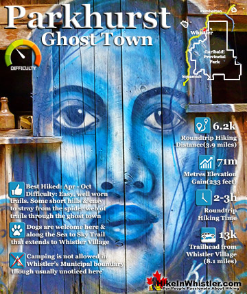
Whistler has an absurd number of wonderful and free hiking trails and Parkhurst Ghost Town certainly ranks as the most unusual and interesting. Parkhurst was a little logging town perched on the edge of Green ...
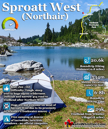
Mount Sproatt, or as it is known locally as just Sproatt, is one of the many towering mountains visible from Whistler Village. Above and beyond Alta Lake, directly across from Whistler Mountain and ...
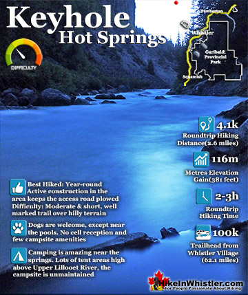
Keyhole Hot Springs (aka Pebble Creek Hot Springs) is located 100 kilometres from Whistler (Village Gate Blvd). Though much of the drive to Keyhole is on logging roads, the route is driveable by most cars ...
July is a wonderful time to hike in Whistler and Garibaldi Provincial Park. The weather is beautiful and the snow on high elevation hiking trails is long ...
August hiking in Whistler definitely has the most consistently great, hot weather. You can feel the rare pleasure of walking across a glacier shirtless and ...
September hiking in Whistler is possibly the best month of all. The snow has melted far up to the mountain tops, yet the temperatures are still quite ...
Hiking in Whistler in October is often unexpectedly stunning. The days are much shorter and colder but the mountains are alive with colour from the fall ...
Hiking in Whistler is spectacular and wonderfully varied. Looking at a map of Whistler you see an extraordinary spider web of hiking trails that are unbelievably numerous. Easy trails, moderate trails and challenging hiking trails are all available. Another marvellous ...
Squamish is located in the midst of a staggering array of amazing hiking trails. Garibaldi Provincial Park sprawls alongside Squamish and up and beyond Whistler. Tantalus Provincial Park lays across the valley to the west and the wonderfully remote Callaghan Valley ...
Vancouver is surrounded by seemingly endless hiking trails and mountains to explore. Massive parks line up one after another. Mount Seymour Provincial Park, Lynn Canyon Park, Grouse Mountain, Cypress Park and the enormous Garibaldi Park all contribute to Vancouver ...
Clayoquot Sound has a staggering array of hiking trails within it. Between Tofino and Ucluelet, Pacific Rim Park has several wilderness and beach trails, each one radically different from the last. The islands in the area are often Provincial parks on their own with ...
Victoria has a seemingly endless number of amazing hiking trails. Most take you to wild and beautiful Pacific Ocean views and others take you to tranquil lakes in beautiful BC Coastal Rainforest wilderness. Regional Parks and Provincial Parks are everywhere you turn ...
The West Coast Trail was created after decades of brutal and costly shipwrecks occurred along the West Coast of Vancouver Island. One shipwreck in particular was so horrific, tragic and unbelievable that it forced the creation of a trail along the coast, which ...
 Hidden oasis in the city
 Huge park often gets busy