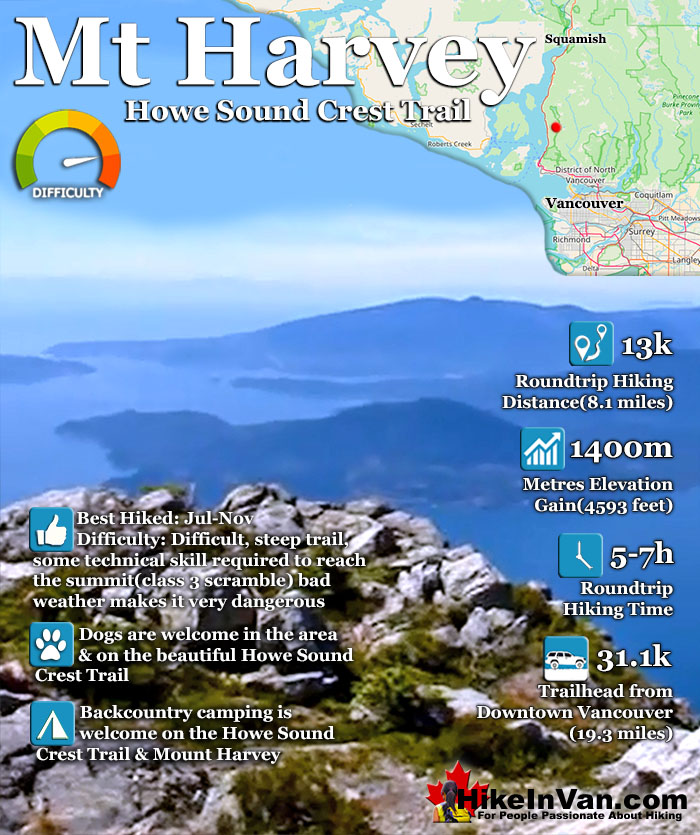
![]() Mount Harvey is one of the huge, visible and hikeable summits in the North Shore mountains. It is located on the Howe Sound Crest Trail in Cypress Provincial Park near The Lions. Reachable via the Howe Sound Crest Trail or by its own trailhead in Lions Bay. The same trailhead used for The Lions, Brunswick Mountain and Mount Hanover. There are no trail use fees, parking fees or camping fees from this trailhead.
Mount Harvey is one of the huge, visible and hikeable summits in the North Shore mountains. It is located on the Howe Sound Crest Trail in Cypress Provincial Park near The Lions. Reachable via the Howe Sound Crest Trail or by its own trailhead in Lions Bay. The same trailhead used for The Lions, Brunswick Mountain and Mount Hanover. There are no trail use fees, parking fees or camping fees from this trailhead.
 Insanely beautiful summit views
- See the Lions from behind
- Near the Howe Sound Crest Trail
- Camping is free & amazing
- The HSCT is dog friendly
- Relatively infrequently hiked
- Challenging & rewarding hike
 Too challenging for most hikers
- Parking is hopelessly inadequate
- Poor weather makes it dangerous
Vancouver Hiking Trails
![]() Black Mountain
Black Mountain ![]() Brunswick Mountain
Brunswick Mountain ![]() Burnaby Lake
Burnaby Lake ![]() Burnaby Mountain
Burnaby Mountain ![]() Coliseum Mountain
Coliseum Mountain ![]() Crown Mountain
Crown Mountain ![]() Cypress Falls
Cypress Falls ![]() Deeks Peak
Deeks Peak ![]() Deep Cove
Deep Cove ![]() Deer Lake
Deer Lake ![]() Dog Mountain
Dog Mountain ![]() Goat Mountain
Goat Mountain ![]() Goldie Lake
Goldie Lake ![]() Grouse
Grouse ![]() Hollyburn Mountain
Hollyburn Mountain ![]() Kitsilano Beaches
Kitsilano Beaches ![]() Lighthouse Park
Lighthouse Park ![]() Lynn Canyon
Lynn Canyon ![]() Lynn Peak
Lynn Peak ![]() Mt Elsay
Mt Elsay ![]() Mt Fromme
Mt Fromme ![]() Mt Hanover
Mt Hanover ![]() Mt Harvey
Mt Harvey ![]() Mt Seymour
Mt Seymour ![]() Mt Strachan
Mt Strachan ![]() Mystery Lake
Mystery Lake ![]() Pacific Spirit
Pacific Spirit ![]() Rice Lake
Rice Lake ![]() St Mark's
St Mark's ![]() Stanley Park
Stanley Park ![]() The Lions
The Lions ![]() Unnecessary
Unnecessary
Mount Harvey is one of the huge, visible and hikeable summits in the North Shore mountains. It is located on the Howe Sound Crest Trail in Cypress Provincial Park near The Lions. Reachable via the Howe Sound Crest Trail or by its own trailhead in Lions Bay. The same trailhead used for The Lions, Brunswick Mountain and Mount Hanover. There are no trail use fees, parking fees or camping fees from this trailhead.
The trail is challenging, though not out of technical skill but due to its steepness of the trail. You gain 1400 metres in just 6.5k. The final scramble to the summit can be dangerous in poor weather, but generally not too difficult. The trail to Mount Harvey is well worn, but poorly marked for the first half of the hike. From the trailhead continue up the old, overgrown logging road. Bear right at the first intersection.
The second intersection you come to, bear right again (left goes to Mt Brunswick). The third junction you come to bear right again. Finally at the fourth intersection you will see a sign for The Lions pointing to the right. You want to take the trail to the left here. This is the crucial trail marker not to miss and therefore it is very visible. From here the trail is easy to follow.
Mount Harvey is part of the amazing Howe Sound Crest Trail in Cypress Provincial Park and is one of the many beautiful peaks to be climbed if desired on the 29k trail. Among the hiker friendly mountains (in order from Cypress north) on the Howe Sound Crest Trail are: Mount Strachan, St Mark`s Summit, Unnecessary Mountain, The Lions, Mount Harvey, Mount Hanover, Brunswick Mountain and finally Deeks Peak.

Driving Directions to Mount Harvey
The trailhead to reach Mount Harvey is the same for The Lions, Mount Hanover and Brunswick Mountain and can be tricky to find. It is located town of Lions Bay which is about an hours drive from downtown Vancouver or a half hour south of Squamish. From either direction on the Sea to Sky Highway, take the Lions Bay exit onto Oceanview Road (the 2nd Lions bay exit from either direction), then immediately turn left onto Cross Creek Road, then right onto Centre Road, then left onto Bayview Road, then left onto Mountain Drive, left again onto Sunset Road and park near the black gate at the dead end. Be sure to park legally as they actively tow illegally parked cars. More parking is available at the school 1 kilometre from here. Arrive early to ensure convenient parking.
Best Whistler & Garibaldi Park Hiking Trails!
Whistler & Garibaldi Park Hiking by Month!


Explore BC Hiking Destinations!

Whistler Hiking Trails

Squamish Hiking Trails

Vancouver Hiking Trails

Clayoquot Hiking Trails
Victoria Hiking Trails

