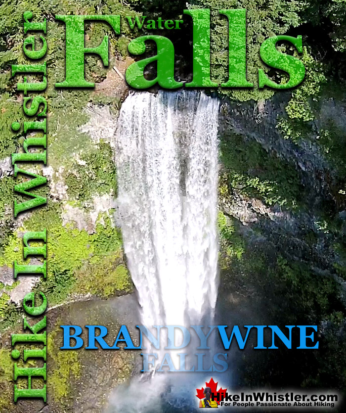
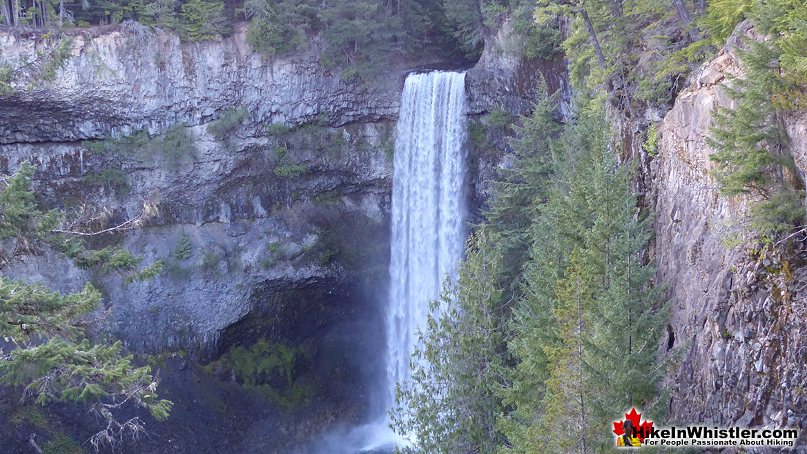
![]() Brandywine Falls is one of the must see sights on the way to or from Whistler. The falls drop from a 70 metre(230 feet), unnaturally abrupt looking cliff to the valley below. Brandywine Falls Provincial Park is such a popular, accessible and beautiful sight that it has a large and elaborate viewing platform directly opposite the falls. Located just 20 minutes south of Whistler, Brandywine Falls is just off of the Sea to Sky Highway.
Brandywine Falls is one of the must see sights on the way to or from Whistler. The falls drop from a 70 metre(230 feet), unnaturally abrupt looking cliff to the valley below. Brandywine Falls Provincial Park is such a popular, accessible and beautiful sight that it has a large and elaborate viewing platform directly opposite the falls. Located just 20 minutes south of Whistler, Brandywine Falls is just off of the Sea to Sky Highway.
Whistler & Garibaldi Hiking
![]() Alexander Falls
Alexander Falls ![]() Ancient Cedars
Ancient Cedars ![]() Black Tusk
Black Tusk ![]() Blackcomb Mountain
Blackcomb Mountain ![]() Brandywine Falls
Brandywine Falls ![]() Brandywine Meadows
Brandywine Meadows ![]() Brew Lake
Brew Lake ![]() Callaghan Lake
Callaghan Lake ![]() Cheakamus Lake
Cheakamus Lake ![]() Cheakamus River
Cheakamus River ![]() Cirque Lake
Cirque Lake ![]() Flank Trail
Flank Trail ![]() Garibaldi Lake
Garibaldi Lake ![]() Garibaldi Park
Garibaldi Park ![]() Helm Creek
Helm Creek ![]() Jane Lakes
Jane Lakes ![]() Joffre Lakes
Joffre Lakes ![]() Keyhole Hot Springs
Keyhole Hot Springs ![]() Logger’s Lake
Logger’s Lake ![]() Madeley Lake
Madeley Lake ![]() Meager Hot Springs
Meager Hot Springs ![]() Nairn Falls
Nairn Falls ![]() Newt Lake
Newt Lake ![]() Panorama Ridge
Panorama Ridge ![]() Parkhurst Ghost Town
Parkhurst Ghost Town ![]() Rainbow Falls
Rainbow Falls ![]() Rainbow Lake
Rainbow Lake ![]() Ring Lake
Ring Lake ![]() Russet Lake
Russet Lake ![]() Sea to Sky Trail
Sea to Sky Trail ![]() Skookumchuck Hot Springs
Skookumchuck Hot Springs ![]() Sloquet Hot Springs
Sloquet Hot Springs ![]() Sproatt East
Sproatt East ![]() Sproatt West
Sproatt West ![]() Taylor Meadows
Taylor Meadows ![]() Train Wreck
Train Wreck ![]() Wedgemount Lake
Wedgemount Lake ![]() Whistler Mountain
Whistler Mountain
![]() January
January ![]() February
February ![]() March
March ![]() April
April ![]() May
May ![]() June
June ![]() July
July ![]() August
August ![]() September
September ![]() October
October ![]() November
November ![]() December
December
![]() Alexander Falls
Alexander Falls ![]() Brandywine Falls
Brandywine Falls ![]() Cirque Falls
Cirque Falls ![]() Holloway Falls
Holloway Falls ![]() Keyhole Falls
Keyhole Falls ![]() Nairn Falls
Nairn Falls ![]() Rainbow Falls
Rainbow Falls ![]() Shannon Falls
Shannon Falls ![]() Train Wreck Falls
Train Wreck Falls ![]() Wedgemount Falls
Wedgemount Falls
Brandywine Falls Provincial Park is wonderful for so many reasons. First it is dramatically beautiful as it plunges from an abrupt cliff. Second it is very easy to get to and easy to hike to. The viewing areas are nicely located and the far viewing area overlooks the massive valley toward Daisy Lake. Brandywine Falls is the main sight in the area, but there are several more great sights around the falls. The Whistler Bungee Bridge is just a short hike or bike ride away along the Sea to Sky Trail. This beautiful bridge spans the massive Cheakamus River and is home to Whistler Bungee. The bridge is always accessible and Whistler Bungee is open year-round, though they are only there when tours are booked. If they are there, you can watch the exciting jumps. If they are not there, the bridge is fantastically serene and the views are tremendous. The Sea to Sky Trail continues north from here to Whistler Village and beyond.
Brandywine Falls Provincial Park
Brandywine Falls Provincial Park was established in 1973 as a campground and recreational area. The origin of the name for Brandywine Falls is thought to have come from a wager by two surveyors. Legend has it that Jack Nelson and Bob Mollison, working for the Howe Sound and Northern Railway made a wager for a bottle of brandy for who could guess how high the falls were. Measured by a chain, Mollison won the wager and bottle of brandy and Nelson named the falls Brandywine.


Swim Lake is another interesting sight to see in Brandywine Falls Provincial Park and is at the end of a short and easy trail off of the main trail near the train tracks. The start of the trail takes you across a small, covered bridge over the river. The trail then continues along the river and leads to the wonderful viewing area across from the falls. The trail then continues another hundred metres to another viewing area. This viewpoint overlooks Daisy Lake, the massive lake that Brandywine Falls empties into. On a sunny day, Black Tusk dominates the skyline here. An unmarked trail continues from this viewpoint and continues along the cliffs and to a very difficult trail down to the base of the falls. The first section requires lowering yourself down by rope, so should only be tackled by the adventurous and very fit.
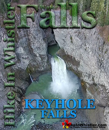
Keyhole Falls - Best Whistler Waterfalls
![]() Mount Meager erupted 2400 years ago and filled the valley with debris that cemented into rock that blocked Lillooet River. Eventually water erosion cut a channel through the breccia dam, and Keyhole Falls were born. The trail to Keyhole Hot Springs shows you plenty of examples of breccia, which is larger pieces of angular rock cemented together with small particles or a mineral cement that forms these marvels. The beautiful Keyhole Falls are just a couple kilometres upriver from Keyhole Hot Springs. The unmarked trailhead and parking area for Keyhole Falls are just a couple kilometres past the parking area for Keyhole Hot Springs. It is easy to find if you have a good idea where it is, see the map below. If you don't have a rough idea where it is, or expect an obvious sign, you will likely get lost in the maze of logging roads in the area. Mount Meager looms high above Keyhole Hot Springs and it, and the surrounding peaks are known collectively as the Mount Meager Complex. The Meager Complex produced the most recent, major volcanic event in Canada in the last 10,000 years. The eruption 2400 years ago spread ash as far as Alberta. More recently, in 2010 a massive debris flow swept down and into the valley causing Pemberton to be evacuated. The eruption 2400 years ago left a huge pumice outcrop 2 kilometres long and 1 kilometre wide. Continued here...
Mount Meager erupted 2400 years ago and filled the valley with debris that cemented into rock that blocked Lillooet River. Eventually water erosion cut a channel through the breccia dam, and Keyhole Falls were born. The trail to Keyhole Hot Springs shows you plenty of examples of breccia, which is larger pieces of angular rock cemented together with small particles or a mineral cement that forms these marvels. The beautiful Keyhole Falls are just a couple kilometres upriver from Keyhole Hot Springs. The unmarked trailhead and parking area for Keyhole Falls are just a couple kilometres past the parking area for Keyhole Hot Springs. It is easy to find if you have a good idea where it is, see the map below. If you don't have a rough idea where it is, or expect an obvious sign, you will likely get lost in the maze of logging roads in the area. Mount Meager looms high above Keyhole Hot Springs and it, and the surrounding peaks are known collectively as the Mount Meager Complex. The Meager Complex produced the most recent, major volcanic event in Canada in the last 10,000 years. The eruption 2400 years ago spread ash as far as Alberta. More recently, in 2010 a massive debris flow swept down and into the valley causing Pemberton to be evacuated. The eruption 2400 years ago left a huge pumice outcrop 2 kilometres long and 1 kilometre wide. Continued here...


Alexander Falls - Best Whistler Waterfalls
![]() Alexander Falls is a very impressive 43 metre/141 foot waterfall just 30 to 40 minutes south of Whistler in the Callaghan Valley. Open year-round and located just before Whistler Olympic Park where several of the 2010 Olympic events were held. There is a nice viewing platform on the edge of the cliff across from the falls which crash fantastically into the valley below. The parking area and viewing platform at Alexander Falls is one big area just 40 metres from the main road, just before Whistler Olympic Park. The adventurous can find the obscure trail that leads to both the top of the falls as well as, with great difficulty, to the base of the falls. Alexander Falls is certainly one of the nicest spots for a picnic in Whistler. The picnic areas are numerous, the surrounding forest is gorgeous and wild and Alexander Falls crashes loud and beautiful in the background. Several picnic tables are located in forested clearings that were once used as campsites, so if you have a big group, you will have lots of room to spread out and enjoy the surroundings. The free parking lot at Alexander Falls is enormous. Keep in mind that it is a day-use only parking area and camping or campfires are prohibited. If you are looking for a place to park overnight in the area the possibilities are endless. Callaghan Valley is very wild, devoid of people and the spider-web of logging roads that cover the valley run for hundreds of kilometres. Continued here...
Alexander Falls is a very impressive 43 metre/141 foot waterfall just 30 to 40 minutes south of Whistler in the Callaghan Valley. Open year-round and located just before Whistler Olympic Park where several of the 2010 Olympic events were held. There is a nice viewing platform on the edge of the cliff across from the falls which crash fantastically into the valley below. The parking area and viewing platform at Alexander Falls is one big area just 40 metres from the main road, just before Whistler Olympic Park. The adventurous can find the obscure trail that leads to both the top of the falls as well as, with great difficulty, to the base of the falls. Alexander Falls is certainly one of the nicest spots for a picnic in Whistler. The picnic areas are numerous, the surrounding forest is gorgeous and wild and Alexander Falls crashes loud and beautiful in the background. Several picnic tables are located in forested clearings that were once used as campsites, so if you have a big group, you will have lots of room to spread out and enjoy the surroundings. The free parking lot at Alexander Falls is enormous. Keep in mind that it is a day-use only parking area and camping or campfires are prohibited. If you are looking for a place to park overnight in the area the possibilities are endless. Callaghan Valley is very wild, devoid of people and the spider-web of logging roads that cover the valley run for hundreds of kilometres. Continued here...


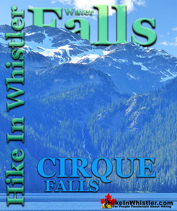
Cirque Falls - Best Whistler Waterfalls
![]() Cirque Falls crashes down from Cirque Lake to Callaghan Lake, connecting these two remarkably beautiful and very different lakes. Where Callaghan Lake is a large, easy to get to mountain lake, Cirque Lake is an extraordinarily serene and hidden lake that takes a bit of planning and effort to get to. Though it is just two kilometres up a steep, yet easily manageable trail, the Cirque Lake trailhead is hidden at the far end of Callaghan Lake. With the massive snowfall and long winters, combined with the rapid, trail-consuming forest growth in BC's Coast Mountains, finding the Cirque Lake trail is mangled, obscured and overgrown. Keeping to the trail and even finding the trailhead would be nearly impossible without the help of Cirque Falls and Cirque Creek. The trailhead, in fact, is so well concealed by the forest that it is completely invisible from the lake. Paddling up to the end of Callaghan Lake and where you assume the trailhead to be leaves you some probable options that entice you away from the actual trailhead. Flatter terrain, gaps in the forest and a more obvious entry point to the forest can be found on the right side of the end of the lake. The left side and middle, you rule out quickly as they are both too steep and the impenetrable wall of the rainforest looks uninviting. Continued here...
Cirque Falls crashes down from Cirque Lake to Callaghan Lake, connecting these two remarkably beautiful and very different lakes. Where Callaghan Lake is a large, easy to get to mountain lake, Cirque Lake is an extraordinarily serene and hidden lake that takes a bit of planning and effort to get to. Though it is just two kilometres up a steep, yet easily manageable trail, the Cirque Lake trailhead is hidden at the far end of Callaghan Lake. With the massive snowfall and long winters, combined with the rapid, trail-consuming forest growth in BC's Coast Mountains, finding the Cirque Lake trail is mangled, obscured and overgrown. Keeping to the trail and even finding the trailhead would be nearly impossible without the help of Cirque Falls and Cirque Creek. The trailhead, in fact, is so well concealed by the forest that it is completely invisible from the lake. Paddling up to the end of Callaghan Lake and where you assume the trailhead to be leaves you some probable options that entice you away from the actual trailhead. Flatter terrain, gaps in the forest and a more obvious entry point to the forest can be found on the right side of the end of the lake. The left side and middle, you rule out quickly as they are both too steep and the impenetrable wall of the rainforest looks uninviting. Continued here...


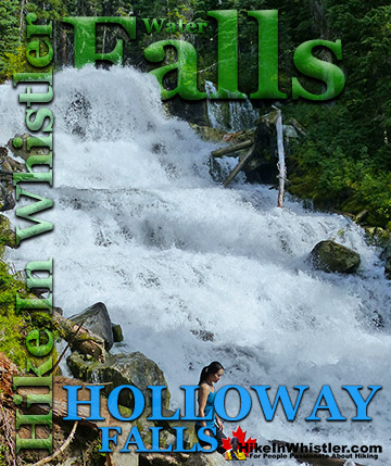
Holloway Falls - Best Whistler Waterfalls
![]() Holloway Falls is the beautiful waterfalls you see partway along the Joffre Lakes Provincial Park trail. Located between Middle Joffre Lake and Upper Joffre Lake, Holloway Falls is a wide, crashing torrent of white water emerging from the forest and rushing past the trail. Huge boulders and logs along the edge with swirling water rushing around them. On a hot day, you can easily dunk your head in the rushing water and cool down. Joffre Creek flows from Upper Joffre Lake to Middle Joffre Lake with Holloway Falls an equal distance between them. Joffre Creek then flows quite some distance to Lower Joffre Lake. It then flows out of Joffre Lakes Provincial Park and runs along parallel to the Sea to Sky Highway for several kilometres to Lillooet Lake. Holloway Falls is not dramatically impressive like other Whistler waterfalls like Brandywine Falls or Alexander Falls. It is more like Rainbow Falls, in that it flows down more gradually, and not over a massive and abrupt cliff. Though compared to Rainbow Falls, Holloway Falls is quite a larger torrent of water flowing through. Joffre Lakes Provincial Park is a beautiful and popular park, well known for its brilliantly, glacier coloured lakes. All three Joffre Lakes are extraordinarily turquoise coloured. On a sunny day, the lakes are hypnotizingly beautiful, surrounded by gorgeous mountains and untouched wilderness. Continued here...
Holloway Falls is the beautiful waterfalls you see partway along the Joffre Lakes Provincial Park trail. Located between Middle Joffre Lake and Upper Joffre Lake, Holloway Falls is a wide, crashing torrent of white water emerging from the forest and rushing past the trail. Huge boulders and logs along the edge with swirling water rushing around them. On a hot day, you can easily dunk your head in the rushing water and cool down. Joffre Creek flows from Upper Joffre Lake to Middle Joffre Lake with Holloway Falls an equal distance between them. Joffre Creek then flows quite some distance to Lower Joffre Lake. It then flows out of Joffre Lakes Provincial Park and runs along parallel to the Sea to Sky Highway for several kilometres to Lillooet Lake. Holloway Falls is not dramatically impressive like other Whistler waterfalls like Brandywine Falls or Alexander Falls. It is more like Rainbow Falls, in that it flows down more gradually, and not over a massive and abrupt cliff. Though compared to Rainbow Falls, Holloway Falls is quite a larger torrent of water flowing through. Joffre Lakes Provincial Park is a beautiful and popular park, well known for its brilliantly, glacier coloured lakes. All three Joffre Lakes are extraordinarily turquoise coloured. On a sunny day, the lakes are hypnotizingly beautiful, surrounded by gorgeous mountains and untouched wilderness. Continued here...


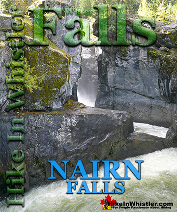
Nairn Falls - Best Whistler Waterfalls
![]() Nairn Falls is a wonderful, crashing and chaotic waterfall that surrounds you from the deluxe viewing platform that allows you to safely watch it from above. The beautiful, green water rushes through the deep and angular channels of rock. Nairn Falls Provincial Park is centred around a very large campground and the short, 1.2 kilometre trail to the falls. You won't find the abrupt drop into a deep chasm like to see with Brandywine Falls. Nairn Falls has a very different shape to it, but is every bit as interesting and scenic. More so, in fact, due to the interesting geological information you find at the main viewpoint over the falls. Nairn Falls crash through various narrow and wide areas, and though the cumulative drop is 60 metres, what you see is a series of 10 to 20 metre falls through a deep, zig-zagging canyon. There are very nicely constructed railings, fences and viewing areas as well as a walkway that guides you to the best views. Continued here...
Nairn Falls is a wonderful, crashing and chaotic waterfall that surrounds you from the deluxe viewing platform that allows you to safely watch it from above. The beautiful, green water rushes through the deep and angular channels of rock. Nairn Falls Provincial Park is centred around a very large campground and the short, 1.2 kilometre trail to the falls. You won't find the abrupt drop into a deep chasm like to see with Brandywine Falls. Nairn Falls has a very different shape to it, but is every bit as interesting and scenic. More so, in fact, due to the interesting geological information you find at the main viewpoint over the falls. Nairn Falls crash through various narrow and wide areas, and though the cumulative drop is 60 metres, what you see is a series of 10 to 20 metre falls through a deep, zig-zagging canyon. There are very nicely constructed railings, fences and viewing areas as well as a walkway that guides you to the best views. Continued here...


Rainbow Falls - Best Whistler Waterfalls
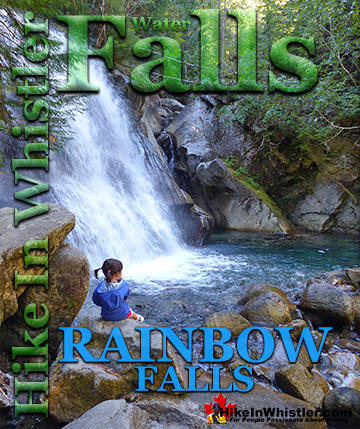
![]() Rainbow Falls is located just a short hike from the start of the Rainbow Trail to Rainbow Lake. The trailhead is along Alta Lake Road on the far side of Alta Lake, just down and across from Rainbow Park. Rainbow Falls are not awe inspiring, however the trail to them is fun and the creek above and below the falls is very scenic. The Flank Trail crosses the Rainbow Trail and 21 Mile Creek just up from Rainbow Falls. A small trail on the far side of the bridge takes you down to the creek bed and the top of the falls. Depending on the time of year, the creek bed may be full of crashing water or half empty and inviting to crawl around the huge, water-smoothed boulders. Rainbow Falls can be tricky to find from the Rainbow trailhead as the trail branches a few times along the way. There is a small Rainbow Falls sign, however it is easily missed, especially in the winter if it is buried in snow. Continued here...
Rainbow Falls is located just a short hike from the start of the Rainbow Trail to Rainbow Lake. The trailhead is along Alta Lake Road on the far side of Alta Lake, just down and across from Rainbow Park. Rainbow Falls are not awe inspiring, however the trail to them is fun and the creek above and below the falls is very scenic. The Flank Trail crosses the Rainbow Trail and 21 Mile Creek just up from Rainbow Falls. A small trail on the far side of the bridge takes you down to the creek bed and the top of the falls. Depending on the time of year, the creek bed may be full of crashing water or half empty and inviting to crawl around the huge, water-smoothed boulders. Rainbow Falls can be tricky to find from the Rainbow trailhead as the trail branches a few times along the way. There is a small Rainbow Falls sign, however it is easily missed, especially in the winter if it is buried in snow. Continued here...


Shannon Falls - Best Whistler Waterfalls
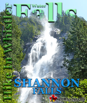
![]() Shannon Falls towers above Howe Sound at 335 metres as the third tallest falls in BC. The wonderful, though very short trail winds through a beautiful old growth forest to get to the base of the falls. From your car to the viewpoint takes only about four minutes. You can continue along the trail and join with the Stawamus Chief trail which goes to the three marvellous summits of The Chief. Shannon Falls Provincial Park has a concession stand as well as an information centre next to the parking area. This parking area is day use only, so if you are hoping to camp overnight in the area, you have to park at the Stawamus Chief parking lot, just a 1 minute drive north of the Shannon Falls lot. If you are planning to hike the Stawamus Chief, the Shannon Falls parking lot is arguably a better place to start from. You can take a look at Shannon Falls and then take the connecting trail to join onto the trail to The Chief. Continued here...
Shannon Falls towers above Howe Sound at 335 metres as the third tallest falls in BC. The wonderful, though very short trail winds through a beautiful old growth forest to get to the base of the falls. From your car to the viewpoint takes only about four minutes. You can continue along the trail and join with the Stawamus Chief trail which goes to the three marvellous summits of The Chief. Shannon Falls Provincial Park has a concession stand as well as an information centre next to the parking area. This parking area is day use only, so if you are hoping to camp overnight in the area, you have to park at the Stawamus Chief parking lot, just a 1 minute drive north of the Shannon Falls lot. If you are planning to hike the Stawamus Chief, the Shannon Falls parking lot is arguably a better place to start from. You can take a look at Shannon Falls and then take the connecting trail to join onto the trail to The Chief. Continued here...


Train Wreck Falls - Best Whistler Waterfalls
![]() Whistler Train Wreck is a hidden little world of brightly graffiti painted, wrecked train cars along a gorgeous stretch of Cheakamus River. One particularly stunning section of the river, unseen by nearly all visitors to Train Wreck, is the marvellously broad and crashing Train Wreck Falls. In the past, the falls were easily spotted on the trail to Train Wreck, but with the recent installation of the bridge to Train Wreck, the access trail was redirected. The new trail to Whistler Train Wreck comes from the opposite direction as the old trail. Designed to avoid the train tracks and inevitable conflicts with CN Rail, the new trail and bridge allows access to Train Wreck without crossing the train tracks. The new trail, however, keeps Train Wreck Falls out of sight. The Trash Trail runs along the other side of Cheakamus River and runs along the edge of the top of the falls and quite a nice view of them. The Train Wreck side of the river has multiple viewpoints of Train Wreck Falls that are considerably more beautiful. Continued here...
Whistler Train Wreck is a hidden little world of brightly graffiti painted, wrecked train cars along a gorgeous stretch of Cheakamus River. One particularly stunning section of the river, unseen by nearly all visitors to Train Wreck, is the marvellously broad and crashing Train Wreck Falls. In the past, the falls were easily spotted on the trail to Train Wreck, but with the recent installation of the bridge to Train Wreck, the access trail was redirected. The new trail to Whistler Train Wreck comes from the opposite direction as the old trail. Designed to avoid the train tracks and inevitable conflicts with CN Rail, the new trail and bridge allows access to Train Wreck without crossing the train tracks. The new trail, however, keeps Train Wreck Falls out of sight. The Trash Trail runs along the other side of Cheakamus River and runs along the edge of the top of the falls and quite a nice view of them. The Train Wreck side of the river has multiple viewpoints of Train Wreck Falls that are considerably more beautiful. Continued here...


Wedgemount Falls - Best Whistler Waterfalls
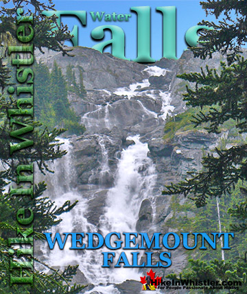
![]() Wedgemount Falls can be seen along the trail to Wedgemount Lake. As the falls flow directly from Wedgemount Lake, they are located about three quarters of the hiking distance from the trailhead. At almost 300 metres high, Wedgemount Falls can be heard long before being visible. The forest cover is very thick for most of the trail to Wedgemount Lake so getting a clear look at the falls is difficult. There is one spot, however, where you will catch sight of them, still kilometres away, yet with such a enormously tall waterfall, you would have to see them from a distance to get it all in view. The falls crash down the almost vertical mountainside, not far from the edge of Wedgemount Lake. You can, if you are fairly brave, hike fairly close to the top of Wedgemount Falls from Wedgemount Lake. Continued here...
Wedgemount Falls can be seen along the trail to Wedgemount Lake. As the falls flow directly from Wedgemount Lake, they are located about three quarters of the hiking distance from the trailhead. At almost 300 metres high, Wedgemount Falls can be heard long before being visible. The forest cover is very thick for most of the trail to Wedgemount Lake so getting a clear look at the falls is difficult. There is one spot, however, where you will catch sight of them, still kilometres away, yet with such a enormously tall waterfall, you would have to see them from a distance to get it all in view. The falls crash down the almost vertical mountainside, not far from the edge of Wedgemount Lake. You can, if you are fairly brave, hike fairly close to the top of Wedgemount Falls from Wedgemount Lake. Continued here...