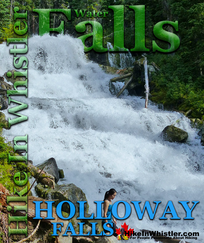
![]() Holloway Falls is the beautiful waterfalls you see partway along the Joffre Lakes Provincial Park trail. Located between Middle Joffre Lake and Upper Joffre Lake, Holloway Falls is a wide, crashing torrent of white water emerging from the forest and rushing past the trail. Huge boulders and logs along the edge with swirling water rushing around them. On a hot day, you can easily dunk your head in the rushing water and cool down.
Holloway Falls is the beautiful waterfalls you see partway along the Joffre Lakes Provincial Park trail. Located between Middle Joffre Lake and Upper Joffre Lake, Holloway Falls is a wide, crashing torrent of white water emerging from the forest and rushing past the trail. Huge boulders and logs along the edge with swirling water rushing around them. On a hot day, you can easily dunk your head in the rushing water and cool down.
Whistler & Garibaldi Hiking
![]() Alexander Falls
Alexander Falls ![]() Ancient Cedars
Ancient Cedars ![]() Black Tusk
Black Tusk ![]() Blackcomb Mountain
Blackcomb Mountain ![]() Brandywine Falls
Brandywine Falls ![]() Brandywine Meadows
Brandywine Meadows ![]() Brew Lake
Brew Lake ![]() Callaghan Lake
Callaghan Lake ![]() Cheakamus Lake
Cheakamus Lake ![]() Cheakamus River
Cheakamus River ![]() Cirque Lake
Cirque Lake ![]() Flank Trail
Flank Trail ![]() Garibaldi Lake
Garibaldi Lake ![]() Garibaldi Park
Garibaldi Park ![]() Helm Creek
Helm Creek ![]() Jane Lakes
Jane Lakes ![]() Joffre Lakes
Joffre Lakes ![]() Keyhole Hot Springs
Keyhole Hot Springs ![]() Logger’s Lake
Logger’s Lake ![]() Madeley Lake
Madeley Lake ![]() Meager Hot Springs
Meager Hot Springs ![]() Nairn Falls
Nairn Falls ![]() Newt Lake
Newt Lake ![]() Panorama Ridge
Panorama Ridge ![]() Parkhurst Ghost Town
Parkhurst Ghost Town ![]() Rainbow Falls
Rainbow Falls ![]() Rainbow Lake
Rainbow Lake ![]() Ring Lake
Ring Lake ![]() Russet Lake
Russet Lake ![]() Sea to Sky Trail
Sea to Sky Trail ![]() Skookumchuck Hot Springs
Skookumchuck Hot Springs ![]() Sloquet Hot Springs
Sloquet Hot Springs ![]() Sproatt East
Sproatt East ![]() Sproatt West
Sproatt West ![]() Taylor Meadows
Taylor Meadows ![]() Train Wreck
Train Wreck ![]() Wedgemount Lake
Wedgemount Lake ![]() Whistler Mountain
Whistler Mountain
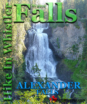
![]() Alexander Falls
Alexander Falls ![]() Brandywine Falls
Brandywine Falls ![]() Cirque Falls
Cirque Falls ![]() Holloway Falls
Holloway Falls ![]() Keyhole Falls
Keyhole Falls ![]() Nairn Falls
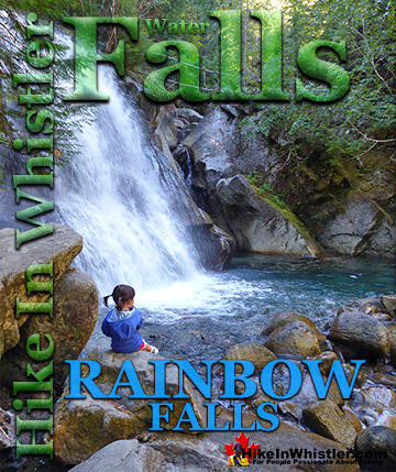
Nairn Falls ![]() Rainbow Falls
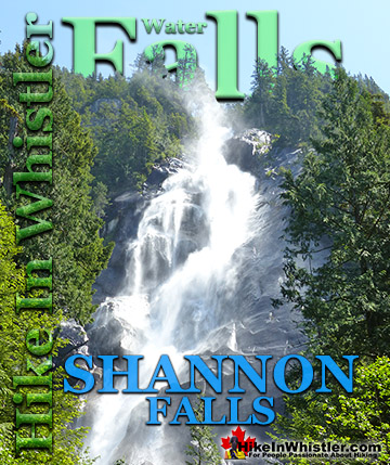
Rainbow Falls ![]() Shannon Falls
Shannon Falls ![]() Train Wreck Falls
Train Wreck Falls ![]() Wedgemount Falls
Wedgemount Falls
![]() January
January ![]() February
February ![]() March
March ![]() April
April ![]() May
May ![]() June
June ![]() July
July ![]() August
August ![]() September
September ![]() October
October ![]() November
November ![]() December
December
Joffre Creek flows from Upper Joffre Lake to Middle Joffre Lake with Holloway Falls an equal distance between them. Joffre Creek then flows quite some distance to Lower Joffre Lake. It then flows out of Joffre Lakes Provincial Park and runs along parallel to the Sea to Sky Highway for several kilometres to Lillooet Lake. Holloway Falls is not dramatically impressive like other Whistler waterfalls like Brandywine Falls or Alexander Falls. It is more like Rainbow Falls, in that it flows down more gradually, and not over a massive and abrupt cliff. Though compared to Rainbow Falls, Holloway Falls is quite a larger torrent of water flowing through. Joffre Lakes Provincial Park is a beautiful and popular park, well known for its brilliantly, glacier coloured lakes. All three Joffre Lakes are extraordinarily turquoise coloured. On a sunny day, the lakes are hypnotizingly beautiful, surrounded by gorgeous mountains and untouched wilderness. The park gets very busy on weekends and the parking lot fills up fast. Though Joffre Lakes Provincial Park is 62 kilometres(38.3 miles) from Whistler Village, the comparatively easy hiking trail and beautiful scenery draws hikers to it year-round. The Joffre Lakes trail is considerably easier than the trails to Wedgemount Lake, Garibaldi Lake, Russet Lake or Elfin Lakes, which is definitely an advantage that overcomes the driving distance to the trailhead.
Holloway Falls in Joffre Lakes Provincial Park


Driving to Joffre Lakes Provincial Park
![]() If you are driving from Whistler, zero your odometer in the Village at Village Gate Boulevard and follow highway 99 north toward Pemberton. From Whistler you will be following the highway signs for Pemberton and Lillooet. At 32km you will arrive at Pemberton, an intersection, with a Petro Can gas station on your left and McDonalds to your right. Continue straight, through Pemberton. At 39km turn right at the sign to Lillooet. Follow this winding road, and soon you will pass Lillooet Lake on your right as the highway ascends steeply. You are only 20 minutes from the parking lot now. At 61.6km, you will see the large Joffre Lakes parking lot on your right. There are several worthwhile stops on the drive to Joffre Lakes. Just five minutes from Whistler Village and you will drive along the edge of Green Lake. There is an excellent pullout on the right side of the highway at a great viewpoint over the lake. Wedge Mountain, Blackcomb Mountain, and Whistler Mountain lay beyond Green Lake. Another 15 minutes driving and you will see the sign for Nairn Falls Provincial Park. A short and easy 1.2 kilometre trail runs along the wild and crashing Green River to a viewing area on cliffs across from the falls. Back on the highway, you reach Pemberton in just 5 minutes. Two gas stations and a McDonald's are at the first intersection you come to. This is the last food or gas until well beyond Joffre Lakes.
If you are driving from Whistler, zero your odometer in the Village at Village Gate Boulevard and follow highway 99 north toward Pemberton. From Whistler you will be following the highway signs for Pemberton and Lillooet. At 32km you will arrive at Pemberton, an intersection, with a Petro Can gas station on your left and McDonalds to your right. Continue straight, through Pemberton. At 39km turn right at the sign to Lillooet. Follow this winding road, and soon you will pass Lillooet Lake on your right as the highway ascends steeply. You are only 20 minutes from the parking lot now. At 61.6km, you will see the large Joffre Lakes parking lot on your right. There are several worthwhile stops on the drive to Joffre Lakes. Just five minutes from Whistler Village and you will drive along the edge of Green Lake. There is an excellent pullout on the right side of the highway at a great viewpoint over the lake. Wedge Mountain, Blackcomb Mountain, and Whistler Mountain lay beyond Green Lake. Another 15 minutes driving and you will see the sign for Nairn Falls Provincial Park. A short and easy 1.2 kilometre trail runs along the wild and crashing Green River to a viewing area on cliffs across from the falls. Back on the highway, you reach Pemberton in just 5 minutes. Two gas stations and a McDonald's are at the first intersection you come to. This is the last food or gas until well beyond Joffre Lakes.

Getting to the Joffre Lakes Trailhead by Bus
![]() From Whistler, Joffre Lakes Provincial Park is 65 kilometres away so driving or public transit are your only realistic choices. There are some companies that do a somewhat regular bus route to Joffre Lakes from Vancouver in the summer months. ParkBus picks up in downtown Vancouver at 730am and returns at 730pm. They do this route all summer long and currently the cost is $69. Check them out at parkbus.ca/joffre.
From Whistler, Joffre Lakes Provincial Park is 65 kilometres away so driving or public transit are your only realistic choices. There are some companies that do a somewhat regular bus route to Joffre Lakes from Vancouver in the summer months. ParkBus picks up in downtown Vancouver at 730am and returns at 730pm. They do this route all summer long and currently the cost is $69. Check them out at parkbus.ca/joffre.

Complete Hiking and Camping Guide for Joffre Lakes Provincial Park

Must See Whistler Waterfalls!

Guides to the Best of Whistler, Garibaldi Park & Sea to Sky!

Explore BC Hiking Destinations!

Whistler Hiking Trails

Squamish Hiking Trails

Vancouver Hiking Trails

Clayoquot Hiking Trails
Victoria Hiking Trails

