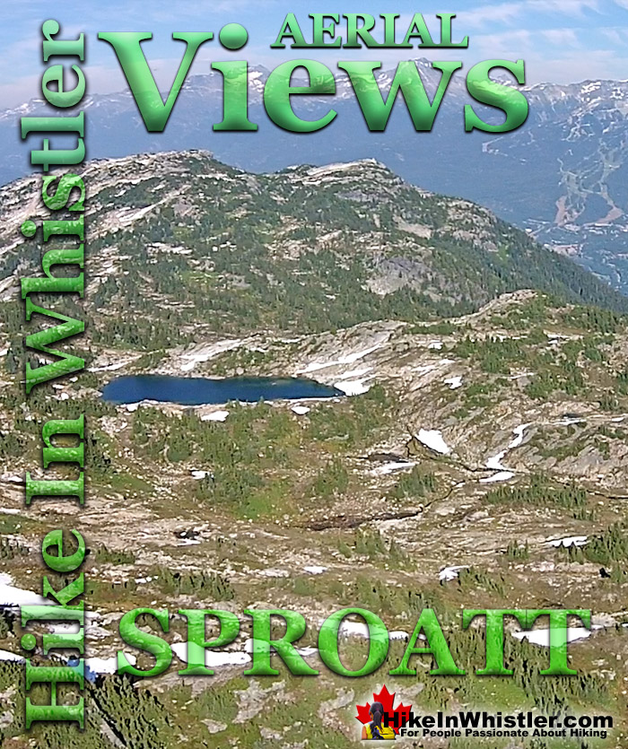
Mount Sproatt, or as it is known locally as just Sproatt, is one of the many towering mountains visible from Whistler Village. Above and beyond Alta Lake, directly across from Whistler Mountain and Blackcomb Mountain, you will see this quiet giant. Its unremarkable appearance hides the growing network of trails that stretch through some startlingly beautiful terrain.
Truck sized erratics in the midst of vibrant green meadows, mountain lakes everywhere you look, and endless open alpine terrain. Mount Sproatt is largely off the radar for most hikers. It doesn't have dramatically beautiful views like you get at Panorama Ridge, Black Tusk, Cheakamus Lake, Garibaldi Lake or Wedgemount Lake. On Sproatt you get a hostile, winter battered alpine that has the wonderful feeling of being unexplored. You can wander in many directions and guess at what you will find. A spectacular little mountain lake, a breathtaking view of Hanging Lake, Sproatt Lake, Alta Lake, Whistler Mountain, Blackcomb Mountain, Rainbow Mountain and quite a lot more. Most trails on Sproatt were built as bike trails and the vast majority of traffic is therefore bikes. If you are biking Sproatt, you generally follow the trails closely and move quickly. If you are hiking Sproatt, you tend to veer off the trails and quickly find yourself on a seemingly deserted alpine paradise. There are many small mountain peaks and some larger ones. Gin Peak and Tonic Peak are two of the larger ones you will encounter and there are dozens of smaller ones. Each is a little world of its own and almost always a world to yourself.
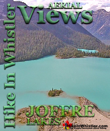
Joffre Lakes Provincial Park is a gorgeous park with extraordinarily coloured lakes, waterfalls, stunning mountain peaks and ominous glaciers pouring into ...
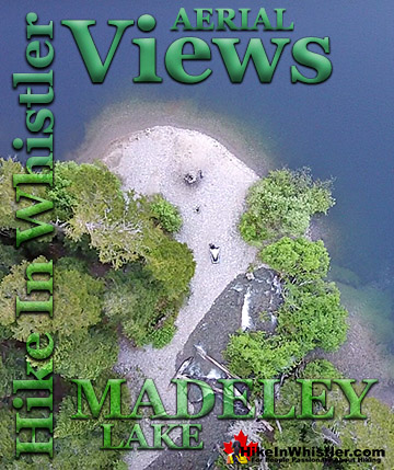
Madeley Lake is a beautiful, remote mountain lake hidden high up in the Callaghan Valley. From Whistler Village expect to take 40 minutes to drive there. Located ...
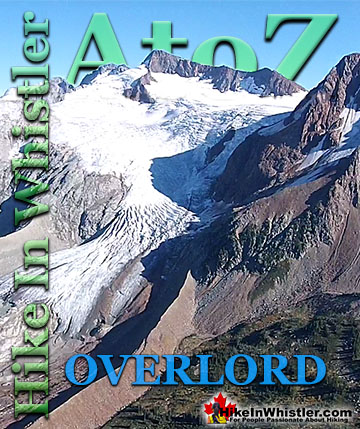
Overlord Mountain is the highest peak in the Fitzsimmons Range. Overlord is surrounded by several mountains that collectively are named the Overlord ...
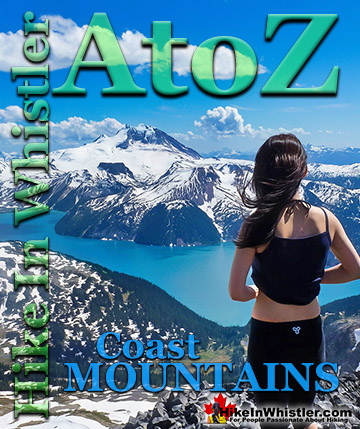
The Coast Mountains run from the Yukon down to Vancouver along the west coast of British Columbia in a band that averages 300 kilometres wide(190 miles). ...
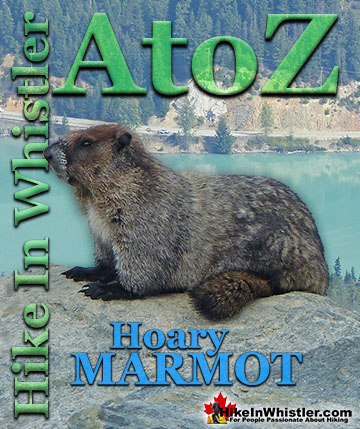
Hoary Marmots are the cute, pudgy, twenty plus pound ground squirrels that have evolved to live quite happily in the hostile alpine areas around Whistler. ...
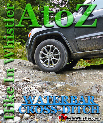
Waterbar and Cross-Ditch: the purpose of a waterbar or cross-ditch is to capture and redirect surface water from the road and channel it across the road ...
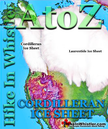
The Cordilleran Ice Sheet covered most of north-west North America for much of the last 2.6 million years. At the Last Glacial Maximum during the Last ...
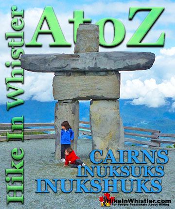
Cairns, inukshuks or inuksuks are a pile or arrangement of rocks used to indicate a route, landmark or a summit. The word cairn originates from the ...
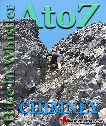
Chimney: a gap between two vertical faces of rock or ice. Often a chimney offers the only viable route to the summit of a mountain. An example of this is Black ...
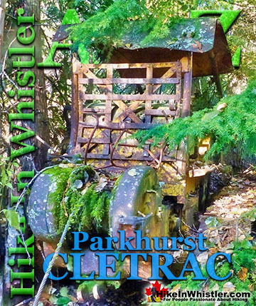
Adjacent to the huge Caterpillar tractor in Parkhurst is a large disintegrating wooden dock that is a great place to take in the wonderful view of Green ...
July is a wonderful time to hike in Whistler and Garibaldi Provincial Park. The weather is beautiful and the snow on high elevation hiking trails is long ...
August hiking in Whistler definitely has the most consistently great, hot weather. You can feel the rare pleasure of walking across a glacier shirtless and ...
September hiking in Whistler is possibly the best month of all. The snow has melted far up to the mountain tops, yet the temperatures are still quite ...
Hiking in Whistler in October is often unexpectedly stunning. The days are much shorter and colder but the mountains are alive with colour from the fall ...
Hiking in Whistler is spectacular and wonderfully varied. Looking at a map of Whistler you see an extraordinary spider web of hiking trails that are unbelievably numerous. Easy trails, moderate trails and challenging hiking trails are all available. Another marvellous ...
Squamish is located in the midst of a staggering array of amazing hiking trails. Garibaldi Provincial Park sprawls alongside Squamish and up and beyond Whistler. Tantalus Provincial Park lays across the valley to the west and the wonderfully remote Callaghan Valley ...
Vancouver is surrounded by seemingly endless hiking trails and mountains to explore. Massive parks line up one after another. Mount Seymour Provincial Park, Lynn Canyon Park, Grouse Mountain, Cypress Park and the enormous Garibaldi Park all contribute to Vancouver ...
Clayoquot Sound has a staggering array of hiking trails within it. Between Tofino and Ucluelet, Pacific Rim Park has several wilderness and beach trails, each one radically different from the last. The islands in the area are often Provincial parks on their own with ...
Victoria has a seemingly endless number of amazing hiking trails. Most take you to wild and beautiful Pacific Ocean views and others take you to tranquil lakes in beautiful BC Coastal Rainforest wilderness. Regional Parks and Provincial Parks are everywhere you turn ...
The West Coast Trail was created after decades of brutal and costly shipwrecks occurred along the West Coast of Vancouver Island. One shipwreck in particular was so horrific, tragic and unbelievable that it forced the creation of a trail along the coast, which ...