![]() January 18th, 2023: Alexander Falls, high up in the Callaghan Valley in Whistler has some interesting historical murals and a mysterious plaque. The information board with as short history of the areas surrounding the falls, complete with museum-like pictures of the regions logging history. One depicts, "A Land of Giants" and describes, with photos, how incredibly huge trees were cut down and moved. One picture from 1910, shows 10 men sitting on an enormous, felled tree and looking tiny by comparison.
January 18th, 2023: Alexander Falls, high up in the Callaghan Valley in Whistler has some interesting historical murals and a mysterious plaque. The information board with as short history of the areas surrounding the falls, complete with museum-like pictures of the regions logging history. One depicts, "A Land of Giants" and describes, with photos, how incredibly huge trees were cut down and moved. One picture from 1910, shows 10 men sitting on an enormous, felled tree and looking tiny by comparison.
Whistler & Garibaldi Hiking
![]() Alexander Falls
Alexander Falls ![]() Ancient Cedars
Ancient Cedars ![]() Black Tusk
Black Tusk ![]() Blackcomb Mountain
Blackcomb Mountain ![]() Brandywine Falls
Brandywine Falls ![]() Brandywine Meadows
Brandywine Meadows ![]() Brew Lake
Brew Lake ![]() Callaghan Lake
Callaghan Lake ![]() Cheakamus Lake
Cheakamus Lake ![]() Cheakamus River
Cheakamus River ![]() Cirque Lake
Cirque Lake ![]() Flank Trail
Flank Trail ![]() Garibaldi Lake
Garibaldi Lake ![]() Garibaldi Park
Garibaldi Park ![]() Helm Creek
Helm Creek ![]() Jane Lakes
Jane Lakes ![]() Joffre Lakes
Joffre Lakes ![]() Keyhole Hot Springs
Keyhole Hot Springs ![]() Logger’s Lake
Logger’s Lake ![]() Madeley Lake
Madeley Lake ![]() Meager Hot Springs
Meager Hot Springs ![]() Nairn Falls
Nairn Falls ![]() Newt Lake
Newt Lake ![]() Panorama Ridge
Panorama Ridge ![]() Parkhurst Ghost Town
Parkhurst Ghost Town ![]() Rainbow Falls
Rainbow Falls ![]() Rainbow Lake
Rainbow Lake ![]() Ring Lake
Ring Lake ![]() Russet Lake
Russet Lake ![]() Sea to Sky Trail
Sea to Sky Trail ![]() Skookumchuck Hot Springs
Skookumchuck Hot Springs ![]() Sloquet Hot Springs
Sloquet Hot Springs ![]() Sproatt East
Sproatt East ![]() Sproatt West
Sproatt West ![]() Taylor Meadows
Taylor Meadows ![]() Train Wreck
Train Wreck ![]() Wedgemount Lake
Wedgemount Lake ![]() Whistler Mountain
Whistler Mountain
![]() January
January ![]() February
February ![]() March
March ![]() April
April ![]() May
May ![]() June
June ![]() July
July ![]() August
August ![]() September
September ![]() October
October ![]() November
November ![]() December
December
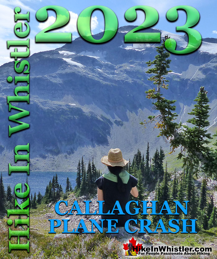
The depiction goes on to show how First Nations people felled trees as long as 8000 years ago. The history of logging continues to present day logging practices in British Columbia and around Whistler are depicted in another nice museum-like mural on BC's "Green Advantage" and sustainable future. The drive to Alexander Falls is very nice. As soon as you turn off from the Sea to Sky Highway into the Callaghan Valley you ascend quickly into the mountains. Bears along the roadside are frequently seen as they seem to have a particular fondness for the fields of grass that grow in the sunny meadows that surround this recently constructed, paved road. On the viewing platform there is a memorial plaque that reads: "In Memory of F/O Gerald S. Stubbs and F/O James E. Miller. Members of 409 Squadron who perished in this area on 22 March 1956." This memorial refers to a mysterious plane crash of a Canadian fighter plane who's occupants have never been found. For several years it was thought that the plane went down in the Pacific as it was flying over from Vancouver Island on a routine training flight in a T-33 Silver Star. Indeed, the search took place over an area 32 kilometres northeast of Comox(Vancouver Island). A considerable distance from where you are at Alexander Falls. The search eventually wrapped up with the assumption that the plane went down in the ocean.
Alexander Falls Stubbs and Miller Memorial

Alexander Falls Viewing Platform

Canopy Found on Mount Callaghan
Two decades later, in the early 1970's, a hiker named Howard Rode found the canopy of the long lost T-33 high up on Mt Callaghan. Rode wrote down the serial number off the canopy and notified the military, who were surprised to discover was the canopy of Stubbs and Miller's plane. A search of the area found no other wreckage. Not surprising if you have hiked in the area. The terrain is a chaotic mix of deep forest, steep terrain, and a maze of enormous erratics and crisscrossed deadfall. In this type of terrain, you can rarely make out landmarks or get a clear sight of where you are going. Searching the area is extremely difficult and the search area that seems small on paper, is monstrous on the ground. It took two more decades for another clue to be found. In 1997 a member of Whistler Search and Rescue spotted plane wreckage as he flew over the area. Four kilometres south and down the valley of where the original canopy was found! Finally, the wreckage could be examined for clues to what had happened. The cause was determined to be fuel starvation. No sign of Stubbs and Miller were found, despite a lot of searching. Another decade would pass before a clue to the two missing airmen was found. A helmet was also found directly between the wreckage and the canopy. Just a helmet. Another set of searches went on, and remarkably, still nothing else found.
Mount Callaghan Above Cirque Lake

Beautiful Cirque Lake

Ejected Seats Still Missing
Somewhere between the wreckage and the canopy, the ejected seats of the fighter plane still lay hidden. Pilots eject from a T-33 with the seats and parachute down to safety. It now seemed evident that Stubbs and Miller ejected the plane before it crashed and possibly survived. Surviving the crash may have been the easy part. Finding civilisation over brutal terrain, deep with snow and in freezing winter temperatures. In March 1956, just like most years, the snow on Mt Callaghan is measured in metres. Eventually another clue will be found as hiking trails continue to be developed in the area and the number of hikers combing the dense forest increase.
The Callaghan Valley in Whistler
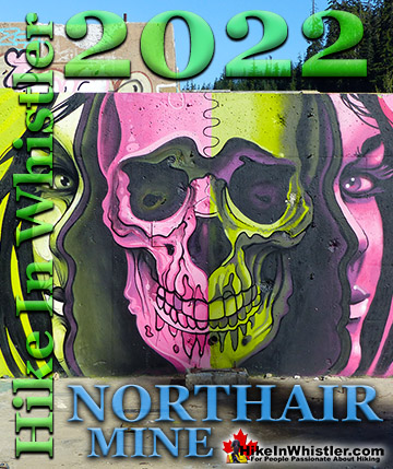
![]() The Callaghan Valley is home to some great places to see. Just past the Alexander Falls parking lot on your left you will see a sign for Callaghan Lake Park. If you turn left here you can either drive straight up a very bad logging road for 8.5 kilometres to Callaghan Lake. Callaghan Lake Park has only a couple short trails. There is, however, a the Cirque Lake trail at the end of the lake takes you to paradise! Cirque Lake is found high above Callaghan Lake and up quite a steep, but short 2 kilometre trail. Well worth the hike, but you have to have a canoe/kayak to get to the trailhead. If you want a quick look at a very pretty mountain lake, take the first right at the start of this logging road that takes you to Madeley Lake. On a sunny summer day, few places in Whistler are more serene and beautiful. A short trail from the end of the road, behind the lake takes you down to a lovely and sunny shore of this crystal clear lake. It is also a free campground that is very nice. Northair Mine is close by and a very interesting place to see, though you need a 4x4 to get up the increasingly deteriorating forest service road.
The Callaghan Valley is home to some great places to see. Just past the Alexander Falls parking lot on your left you will see a sign for Callaghan Lake Park. If you turn left here you can either drive straight up a very bad logging road for 8.5 kilometres to Callaghan Lake. Callaghan Lake Park has only a couple short trails. There is, however, a the Cirque Lake trail at the end of the lake takes you to paradise! Cirque Lake is found high above Callaghan Lake and up quite a steep, but short 2 kilometre trail. Well worth the hike, but you have to have a canoe/kayak to get to the trailhead. If you want a quick look at a very pretty mountain lake, take the first right at the start of this logging road that takes you to Madeley Lake. On a sunny summer day, few places in Whistler are more serene and beautiful. A short trail from the end of the road, behind the lake takes you down to a lovely and sunny shore of this crystal clear lake. It is also a free campground that is very nice. Northair Mine is close by and a very interesting place to see, though you need a 4x4 to get up the increasingly deteriorating forest service road.

More Whistler Updates!

Whistler & Garibaldi Park Hiking Glossary A to Z
Whistler & Garibaldi Park Best Hiking by Month!


Explore BC Hiking Destinations!

Whistler Hiking Trails

Squamish Hiking Trails

Vancouver Hiking Trails

Clayoquot Hiking Trails
Victoria Hiking Trails

